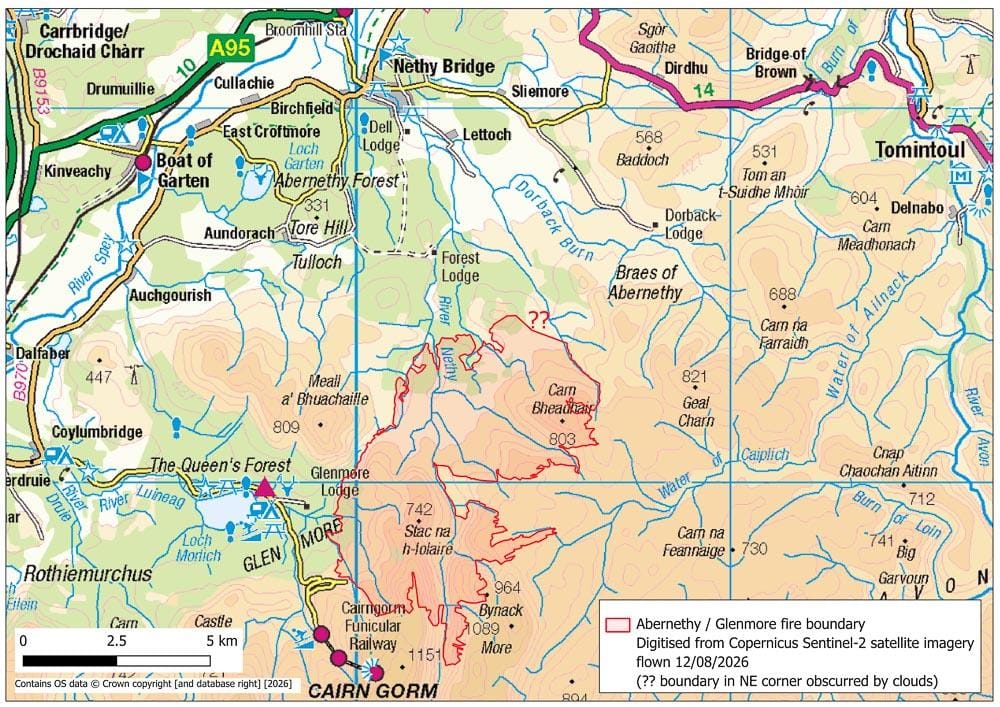
UPDATE (24th August)
Copernicus satellite imagery flown on 21/08/2026 gives a cloud free view of the north-east corner of the area burnt in Abernethy Forest. I have therefore been able to revise the maps of the Abernethy – Glenmore wildfire, and have added updated maps to the Google Drive folder (link in blog post below). Look for: Abernethy – Glenmore fire boundary map (Open Topo map back drop) – updated 23 08 2026.jpg and Abernethy – Glenmore fire boundary map (OS back drop) – updated 23 08 2026.jpg. I have also added the revised shapefile boundary as a zip file – Abernethy Glenmore fire boundary REVISED version 2 (incl Copernicus 21 08 2026).zip. The revised area of the wild fire is 32.74 km2.
At the time of writing (19th August) no map has been published showing the actual extent of the Abernethy – Glenmore wildfire. Given that such a map would be of wide public interest, I kept an eye on the Copernicus Sentinel-2 L2A satellite imagery, and the one flown on 12/08/2026 was the first occasion when the area of the Abernethy – Glenmore wildfire was largely free of cloud. The only part of the fire boundary obscured was the north-east corner near Carn a’ Chnuic.
The fire boundary was digitised from the Copernicus satellite image, and used to create two maps. One gives the wider context (header of this blog), the other a more detailed view. The maps are available in a Google Drive folder – HERE. (If the folder doesn’t open, right click > copy hyperlink > paste into your browser. If needed, links to the individual maps / files are given at the end). Download the maps to view at full resolution.
In addition this folder contains the Copernicus satellite image with the digitised boundary as an overlay, a READ THIS file (giving some details of how the fire boundary was digitised), and a zip file containing the fire boundary in shapefile format.
The area within the digitised fire boundary is 32.42 km2, considerably larger than the c.25 km2 widely reported elsewhere. The boundary on the maps I created includes lochans and scree slopes, as well as some grasslands and flushes that did not burn. Conversely the north-eastern limit of the fire is not mapped, as the area was obscured by clouds when the satellite image was made.
READ THIS file (pdf) – HERE
Overview map showing location of the fire – HERE
Detailed map of the fire extent – HERE
Copernicus image with fire boundary – HERE
Digitised boundary (shapefile) – HERE

Well done – thanks for looking at this closely. I was just trying to find out this information and couldn’t find an accurate assessment of the extent of the damage anywhere else.
Thanks for the clarifications on area burned Andy, although as you say this is likely to be revised later. It is interesting that the official sources are behind in publishing the extent of the wildfire – my suspicions and paranoia setting in.
One thing which I believe is clear is that the UK needs to redefine what a mega wildfire is in the UK. Currently, (in line with European definitions) a wildfire needs to exceed 10,000 hectares to be defined as a megafire. At the moment the Cairngorms wildfire is only just over 3,000 hectares, if my arithmetic is correct, whilst the Dave Moor fire is recorded at 11,827 hectares. I think most people would agree that the Cairngorm wildfire has been a very serious wildfire, both in area burned and CO2 consumed through peat burning. I believe there needs to be a review of the wildfire area threshold for the UK……. and an additional criterium – the estimated amount of CO2 emitted, which will gather in wildfires where significant quantities of peat have been burned. Will our Governments listen – I doubt it!
The combined Carrbridge – Dava fire may have been smaller than the figure you quote (which I have also seen). The Scottish Wildfire Forum published figures of 9,664 ha and 9,752 ha – https://www.scottishwildfireforum.co.uk/newspost/swf-statement-on-morayshire-wildfires. The 9,752 ha comes from detailed mapping by Cawdor Forestry Ltd.
There are 100 hectares to a sq km, so the Cairngorm wildfire is about 32420ha according to this mapping.
32.42 km2 x 100 = 3242 ha (not 32420 ha – that would really have been a megafire!)
Oops! How did I get that wrong??
I seem to remember while the Cairngorm fire was burning that it was said to be bigger than the Dava/Carrbridge one, which obviously from these figures it wasn’t, although it burned for longer. So in terms of the definition that Gordon Bulloch quoted, Dava was there or thereabouts, but Cairgorm was a long way short of it. I’ve never had cause previously to look at a megafire definition, but (perhaps naively) I’d have thought that the Cairngorm one would count.
Very useful contribution to understanding what happened there. Well done.
Very useful. At some point it would also be handy to see a map showing the extent of the firebreaks created hurriedly as the fire became more extensive.
Hopefully RSPB / FLS will be producing (and publishing) a detailed account of how the fire spread, a definitive map of the burnt area, and how the fire was tackled, including resources deployed, what worked well and what didn’t.
The Copernicus satellite image used for the maps I created was that of 12th August. The pre-fire satellite image of 13th July is cloud free (for links see update above). Note, it takes a few moments for the satellite image to appear. Comparing the pre to post-fire images you can discern new firebreaks (mainly on Glenmore) and existing tracks that were widened. A firebreak was also created along the line of the former power line, just south of Nethy Bridge, but that is not visible on any of the existing satellite images.