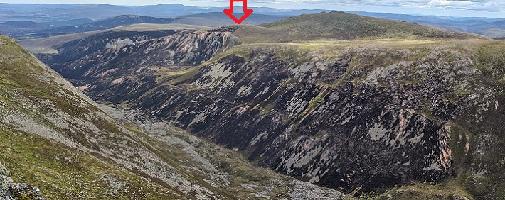
The extent of the Abernethy – Glenmore wildfire has been mapped (HERE). In QGIS a grid of 100 m sided cells was overlain over the fire boundary polygon, and clipped to match the boundary. The mean altitude within each cell was calculated using the Copernicus GLO-30 Digital Elevation Model, downloaded via the OpenTopography website. This is a global 30m grid of altitudinal data.
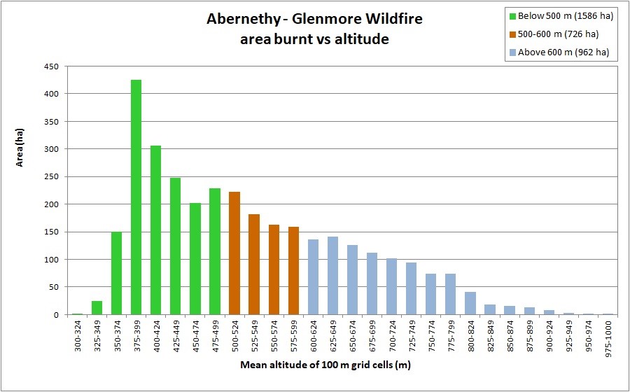
The altitudinal range of the fire was from 320 m to 981 m. 52% of the area burnt was above 500 m and 29% was above 600 m (chart below).
The ‘treeline ecotone‘ comprises ‘treeline woodland‘ and ‘montane scrub‘ (Gilbert, 2010; Amphlett, 2024; see diagram below). The lower altitudinal limit of treeline woodland (the ‘forest line’), is the altitudinal limit of erect tree growth above which trees become wind-pruned and increasingly stunted. In the Cairngorms this change in growth form is most apparent in Scots pine. Trees growing above the forest line show a number of characteristic features including: ‘flagging’ (branches mainly found on the lee side of the trunk); presence of a low ‘skirt’ of branches, hugging the ground; twisted trunks and branches; and reduced height. In the Rothiemurchus, Glenmore & Abernethy area the average potential ‘forest line’, on north-west to south facing slopes is at about 560-590 m. However, on isolated hilltops this can be reduced to c. 500 m.
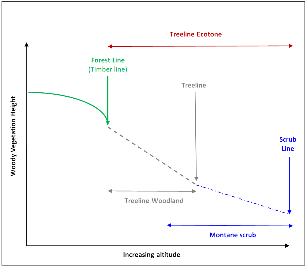
‘Treeline woodland‘ comprises stunted trees above the forest line. The upper limit of this zone (the ‘treeline‘) is usually defined as the altitude of the uppermost trees with a minimum height of 2m. ‘Montane scrub‘ extends from a little below the treeline up to the scrub line. The ‘scrub line‘ is the potential altitudinal limit beyond which tall-shrub species cease to grow or are no more than occasional in montane (alpine) zone vegetation.
It is notable therefore that about half the area burnt is within the ‘treeline ecotone’ (here between 500 and 1000 m altitude) (Amphlett, 2024).
To date, many comments about the fire have (understandably) addressed perceived impacts on mature woodland and tree regeneration. Because the upper edges of both Abernethy and Glenmore forests consist of scattered patches of woodland and individual mature trees, along with tree regeneration of varying ages, densities and heights, it is hard to define a woodland area. Pre-fire aerial photography has sufficient resolution to show woodland and scattered trees (see below – the full resolution image can be downloaded HERE).
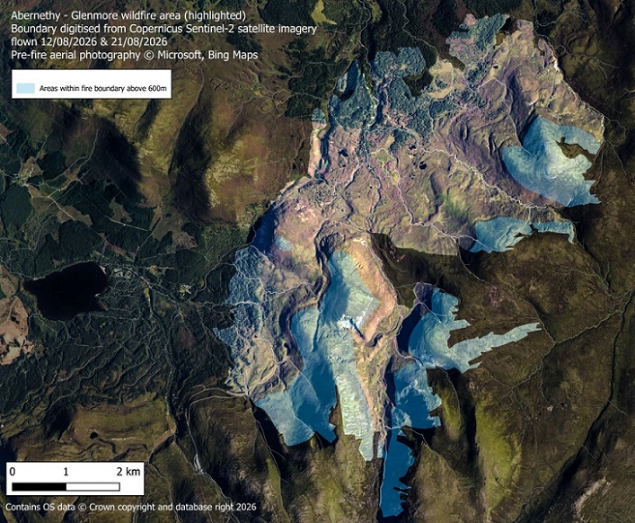
Above 600 m vegetation height (and fuel load) are mostly limited by exposure, extremely so as altitude increases. Even so, 962 ha above 600 m was affected by the fire, and the maximum altitude reached by the fire was c. 980 m above Coire Laogh Mor and c. 940 m on Bynack Beg. It is not clear if the fire petered out as it encroached into patchy montane vegetation communities, or if the minimal fuel load made it easier for people tackling the fire to extinguish it.
Woodland, isolated trees, along with established tree regeneration are visible on online aerial photography. Using the 100m grid referred to above, and just selecting those cells that contained visible trees or tree regeneration, indicates that c.38% of the fire area contained trees and / or regeneration. This area was restricted to the western and northern parts of the fire area, mainly at lower altitudes. Ground survey would no doubt increase this percentage.
In summary, therefore, a minimum of 38% of the fire area contained trees and / or regeneration, 33% of the fire area was moorland (below 600 m, that lacked (visible) trees and regeneration), and 29% of the fire area was above 600 m. Some trees and regeneration occur above 600 m, so there is a slight overlap in these categories.
The Cairngorms National Park comprises 58% moorland (heathland and peatland), 17% woodland and 12% montane habitats. The Abernethy – Glenmore fire (3274 ha) and the Carrbridge – Dava fire (9752 ha, that burnt in late June – early July 2025), indicate that almost all moorland, woodland, and some lower altitude montane habitats within the Cairngorms National Park can potentially burn, if weather conditions lead to a sufficiently high wildfire risk. The potentially flammable habitats within the CNP amount, therefore, to at least 75% of the park area. Tree regeneration, and any developing treeline woodland and montane scrub are likely to be severely impacted if affected by wildfires.
The assemblage of species impacted by the fire above 600 m, while overlapping with that at lower altitudes, will differ. Assessment of the impacts of the fire, and of recovery, should consider the whole altitudinal range affected. Vegetation recovery might reasonably be expected to be slower at higher altitudes, increasing the risk of erosion in periods of heavy rain or snow-melt.
References
Amphlett, A. (2024). Tree and scrub species of the Treeline Ecotone in the Cairngorms National Park, Scotland. British & Irish Botany, Vol. 6, No. 1. (HERE)
Cairngorms National Park. Current habitat of the Cairngorms. (HERE). Accessed 01/09/2026.
Gilbert, D. 2010. Interactions between climate and land use which drive dynamics in treeline ecotone scrub in Scotland. A thesis presented for the degree of Doctor of Philosophy at the University of Edinburgh.
Scottish Wildfire Forum (2025). SWF statement on Morayshire Wildfires – Updated 10.07.25. (HERE).

Aye, makes you wonder about the effects of anthropogenic fires, when the more extensively settled upland cultural landscape was impacted by the burning effects induced in the wars of the 500-1000AD period between Picts, Vikings, Britons, Scots and Anglo-Saxons, then subsequently in the Wars of Independence and clan rivalries.
I think fire has had a MUCH more important role to play in destroying our forests in the past than we imagine.
Aye, indeed Victor
The Cairngorm SAC citation gives the following description. Creag Fhiaclach is unique in having the most natural altitudinal tree-line in the UK. At around 640 m there is mixed tree-line woodland with stunted Scots pine Pinus sylvestris and juniper, giving way at higher altitude to alpine juniper scrub. The alpine juniper scrub is developed extensively and often occurs in a stunted form transitional between ssp. communis and ssp. nana.
The Cairngorm Club Jounal of 1900 carries a remarkably detailed first hand article by Caleb Cash FRSGS about the major fire in 1899 in the same area, up to around 650m described in the citation and includes an accurate hand drawn map. Cash was a geographer, ecologist, cartagrapher and pioneer Cairngorm mountaineer. He knew his hills. Cash wrote…..
And now it is possible to survey the ground, and see what damage has really been done. On the accompanying
map the red tint shows the burnt area. It will be seen that this lies between the east side of Loch Gamhna and the
south side of Loch an Eilein on the one hand and the slopes of Creag Fhiaclach and Creagan bun Suinn on the other.
The total area affected is about 450 acres, and throughout this, with but little exception, all the undergrowth of grass,
heather, and juniper is completely destroyed.
Seems remarkable that after just 80 years and at altitude a site burnt through by a fire ignited by a discarded match or cigarette then grazed by deer appears to have becomes become one of the most celebrated natural sites in the UK.
CC Journal may be read online
here
This is very helpful – it shows there may also be hope at altitude – and that RSPB and FLS should not use the fire as an excuse for more montane planting. It also raises serious questions about why the CNPA funded planting in Coire na Ciste and why NatureScot consulted earlier this year on planting montane areas close to Greag Fhiaclach. I do not recall any mention of this fire or the recovery in that consultation (which I have still to blog about)
Duncan, thank you for alerting me to this account. As you say, the map is pretty accurate, i.e. the position of features such as the lochs matches modern OS maps well. I have therefore been able to overlay the 1899 fire over Bing air photos. Two images are available at this link – https://drive.google.com/drive/folders/14OAptRIzSQ6ncBhnuyVa28FWRByAmUax?usp=sharing – one with contours the other without.
The celebrated treeline at Creag Fhiaclach is actually immediately south of the southern limit of the 1899 fire, and extends to the Allt Coire Follais, so was not burnt. If you zoom in on the area of the fire, while there is a lot of woodland, there is still a considerable area of open ground.
Mature pine dominated woodland at lower altitudes, with a continuous tree canopy, shows some evidence of being resistant to fires. Shading reduces Heather and encourages Blaeberry, so field layer fire intensity will be lower. But treeline woodland and subalpine scrub will always be susceptible to significant impacts if fires should occur.
The account of the 1899 fire is available here – https://cairngormclub.org.uk/club-journal/ – It is in Issue No. 14, and is well worth reading.
Thanks Andy. Good to have the clarification. The air photos also usefully show what I believe was the extent of war time felling as a distinct line across Creag Fhiaclach. i’m sure I have seen an old B/W photo across Loch an Eilein showing the ground on the hill behind as quite bare. Before they moved entirely to Lochaber this site was popular with the Six Day Motor Bike Trials and where Royal Indian Army Service Corps Force K6 – Animal Transport Company practiced with their mules. Bit of extra grazing pressure? Both activities here perhaps because it was an old fire site. The 1899 fire also appeared to burn uphill north to south. Have you seen a plan of the 1960 Glenmore fire? It may have burned south/north too through the Sluggan. The recent Glenmore/Abernethy fire has the more tear drop shape driven SW and then NE by prevailing winds ( which swung round mid fire) and uphill on steeper terrain to the altitudes you describe. Modelling wind and terrain alongside fuel load and dryness must expose site vulnerabilities and propensities to burn.
An interesting case last week where the former Chief Executive of Mid and Est Antrim local authority was found guilty in the Limavady court of two charges connected to deleting or attempting to delete email to alter the perception of information that should have been provided.
No longer in post now being convicted and fined £1,500 this prosecution brings into sharp focus how officials in councils and other public bodies need to be honest when providing information.
In the light of the Fiona Higgins judicial review decision handed down by Lord Sandison last month the Standards Commission were found to have acted illegally denying a fair hearing. denying amongst other things the admittance of evidence. This landmark decision has now given rise to the circumstance whereby many previous cases are now being reviewed, and within the volume of the cases being reviewed, one wonders to what extent evidence not admitted, or indeed evidence with held or evidence potentially altered, may emerge as not standing up to scrutiny.
Probity of action by officials is at the heart of public service and this prosecution reinforces that requirement.
To avoid confusion among readers, this comment appears to relate to/have implications for the Sid Perrie case which has been extensively covered on Parkswatch. I will try and pick up on this judgement and other recent judgements which could be relevant to the Sid Perrie case in future posts.