This post provides a follow-up to the uncontrolled fires I observed on Morar on 25th April (see here).
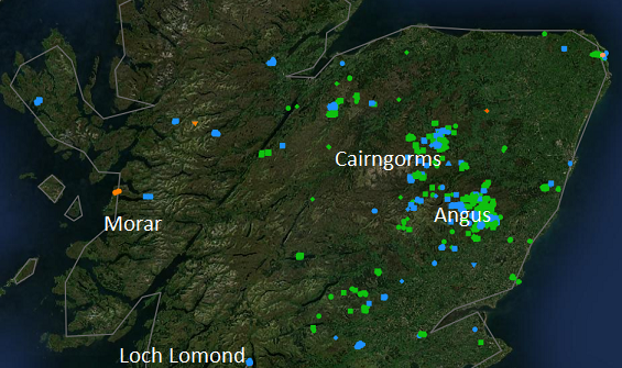
The map shows that so far this year far more land has been burned in the east of Scotland than the west and that most of these fires have been on intensively managed grouse moors in the eastern Cairngorms and Angus. This illustrates that most land in Scotland is burned intentionally, for land management purposes, rather than accidentally as in the recent ‘grass’ fire at Tarbet on Loch Lomond shown at the bottom of the map.
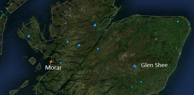
NASA FIRMS (Fire Information for Resource Management System) and EFFIS (the European Forest Fire Information Service) both allow views to search for fires recorded over specific time periods. Under the current Muirburn Code the muirburn season ends on 15th April. Although strongly discouraged, muirburn can continue with the permission of the landowner until 30th April. This map shows that grouse moor managers in the east, with the notable exception of Glen Shee, appear more likely to adhere to the advice in the Muirburn Code than those in the west. Indeed, in the west most of the fires that have happened far this year have been after the end of the muirburn season.
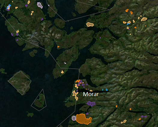
EFFIS also shows that since 2022 some areas on the west of Scotland and Skye have been burned and others not. The clusters of burned areas on this map are strong indications of muirburn. The number of fires on Morar, for example, contrasts with the complete absence of fires on the Knoydart peninsular immediately to the north.
The evidence shows that some crofting areas, like Morar and North Skye, are intensively burned but others are not. (While off the screenshot, EFFIS records no fires in this period for Ardnamurchan to the south). The map also shows that some sporting estates, most notably Killilan, Inverinate, West Benula and Glomach in the top right corner, burn extensively. Such burning is normally intended to ‘improve’ grazing for deer and will become unlawful once the muirburn licensing scheme is implemented.
The larger burned areas on Morar are indicative of fires that have got out of control – ‘wildfires’. The cluster around the west end of Loch Morar strongly suggests that most of these were started by crofters. Muirburn is generally far less closely managed on the west than the east – I have been informed by several sources that some crofters pour a can of petrol on the land, throw a match on it and then walk away – and as a result far more muirburn gets out of control and turns into what are normally described by the media wildfires.
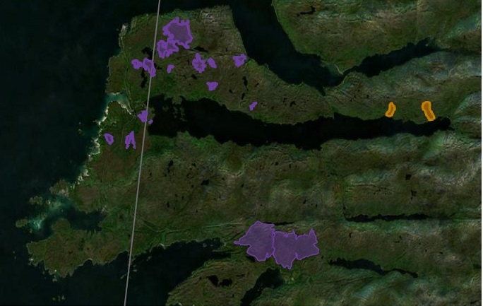
Unfortunately, because the Scottish Fire and Rescue Service do not investigate the causes of these ‘wildfires’, it is very difficult to prove who is responsible on a case by case basis. For example, the two large fires last year by the Fort William to Mallaig Road (bottom of map) which destroyed significant areas of birch woodland could in theory have been caused by a lighted cigarette tossed out of a car window. The likelihood, however, of two fires so close together being started accidentally in such a short time period pf time – the left hand area was burned on the 20th April 2025 and the right hand area on the 22nd – is very low.
That partly explains why I included the two fires I saw on the North Morar Deer Forest/Estate (orange on map) on 25th April this year were deliberate. The fact that, as EFFIS shows, both were started by the loch shore in an area most easily accessed by boat also suggests estate staff were responsible.
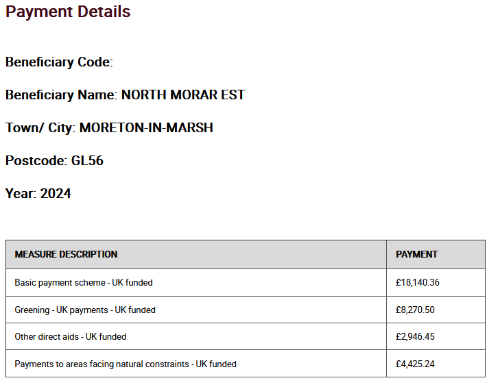
Just how the North Morar Deer Forest, as this estate is known on the Registers of Scotland, persuaded the Scottish Government’s Rural Affairs and Economy department to award it £33,782.55 in 2024 is unclear. It appears, however, the estate is now farming as well as shooting deer.
Unfortunately, 2024 is the last year that rural payments were recorded on the DEFRA website and that is due to close for good in May 2027. While the website (see here) claims ‘the UK Government remains committed to full transparency in the use of public funds, including the publication of details about all payments made under the CAP,’ it does not explain what arrangements either the UK or Scottish Governments are making to publish this information in future. (I have submitted an Information Reqest to find out).
Basic cross-compliance should mean public funds are never awarded to landowners who ignore the Muirburn Code. Rural payments could therefore potentially provide an important means of changing the behaviour of land-managers and ensuring they comply with the requirements of the muirburn licensing scheme when this comes into effect. I will raise this matter with the local Scottish Government Rural Payments Division office on Skye and ask if they are still making payments to the estate.
It will be interesting to see the response but on the wild west of Scotland, where people are so reluctant to report their neighbours and where the police seem incapable of taking action, a financial stick may be the best way of stopping so much land going up in smoke. Alongside that, however, the rural payments system needs to be reformed so crofters can earn a living without having to use fire to promote grassland at the expense of moorland and woodland.
While most of NatureScot’s focus in revising the Muirburn Code and preparing for the implementation of the muirburn licensing scheme has been on grouse moors in the east, they also need to pay attention to the rather different issues in the west, as evidenced by what is going on in Morar. These issues should also be high on the priority list of whoever, after the elections, becomes the next Cabinet Secretary responsible for rural affairs.

Nick . Your piece mentions a local reluctance to talk about things going on with which near crofting neighbours or those employed by larger estates who live among them might be concerned.
An important aspect of this might be to cross reference those who volunteer themselves to train for local fire fighting efforts, with occurences of spring time fires nearby. One volunteer activity for crofters is to make themselves available.
As with MCA coastguard crews, an hourly financial reward for a recorded call-out of these retained local volunteers is often made.
(The suspicion exists, and after any larger event evidence as to actual cause becomes impossible to gather. I dare say no more.)
One of the problems with fires on peat is knowing that it is finally out. Peat can smoulder underground after the fire is quelled. Take one experience I have had. I sold off a stand of sitka we had inherited with our croft and I had to burn the brashes. I did, and then, aware that the thick layer of semi-rotted spruce needles that had built up over 40-50 years was just like a kind of peat, I put a trickle hose on the site of the brashings for 36 hours and spread out the ashes to cool. We were taking a Dutch friend to the Cairngorms that day and I did not realise that, trying to be helpful in that tidy Dutch way, he had carefully gathered up my carelessly scattered ashes into a neat pile before we left. On return I found the ashes had relit and burned out. At least that was finished.
BUT NO! Ten days later my wife came home from work to receive a phonecall from Edwin – our mechanic but also a volunteer with the local fire service. “Is that you Mrs Watson?” “Yes” “Weel dae ye ken that henhoosie oh yours?” “Yes” “Weel! Its nae there noo!” The fire had crept under ground over a meter a day to surface under our “henhoos” some 15 meters away, leaving us only with two redundant door hinges and brass bolt – in case any of you are interested. NOW! DON’T GET WORKED UP! There were no chickens in it! And at least they paid us £900 for the timber. But seriously it was a demonstration of what can happen with muirburn – much of which takes place over peat.
Hi Drennan, this is a very good illustration of what happened with the first Dava Moor fire, the biggest recorded in Scotland. The fire was lit by a helicopter flare, estate staff and the fire service as I understand it thought they had put it out, but it smouldered on before breaking out a few days later.