Walking in to Oban bothy over Meith Bheinn from Lochailort on Friday afternoon I did not know that the Scottish Fire and Rescue Service had issued a warning of extreme risk of wildlife for the West of Scotland (see here). Although squelching over the lower ground, higher up it was very dry underfoot. I had been in the Morar area a few days earlier and it was amazing the difference a few days of sunshine and wind had made after the very wet start to the year.
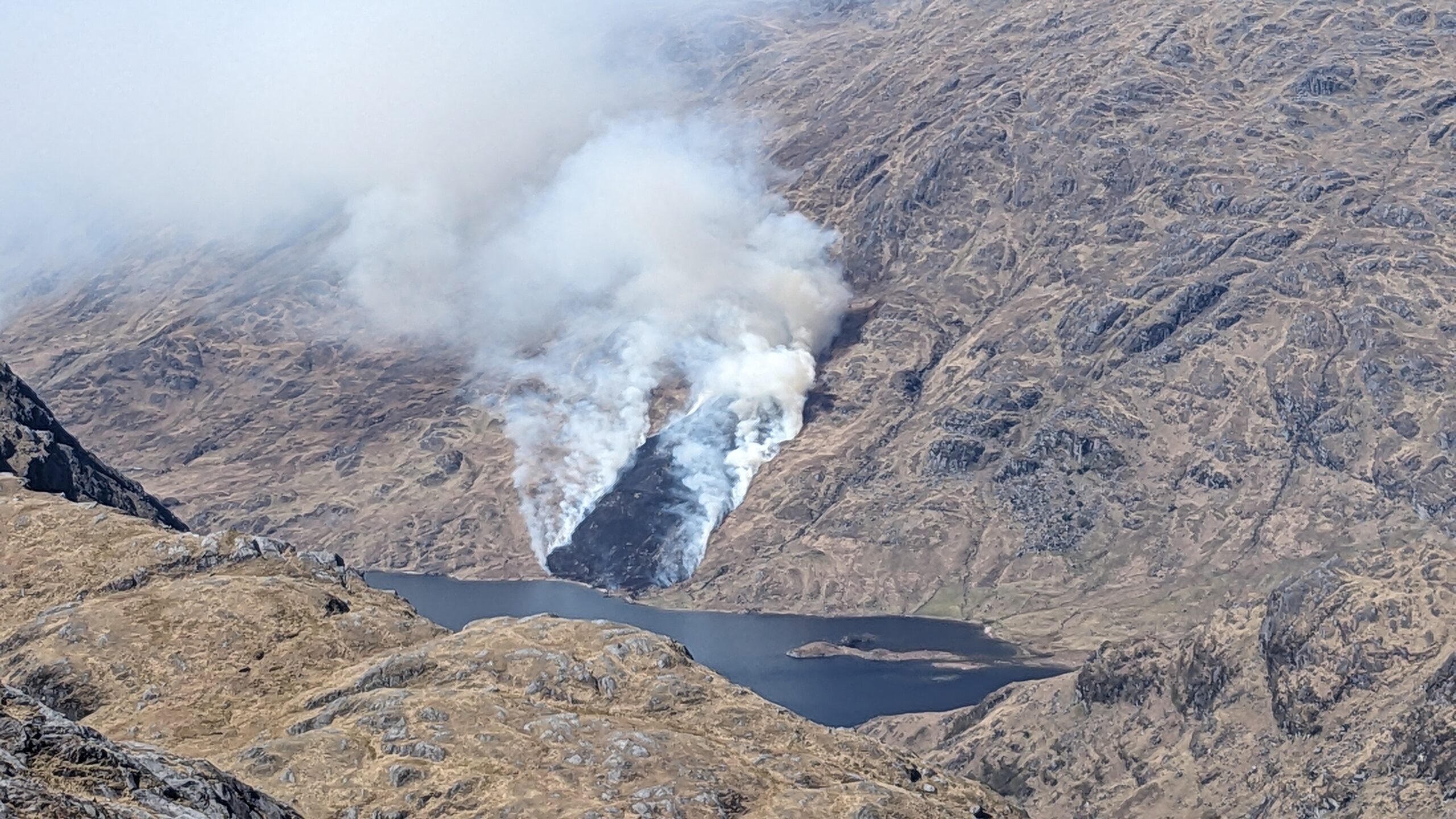
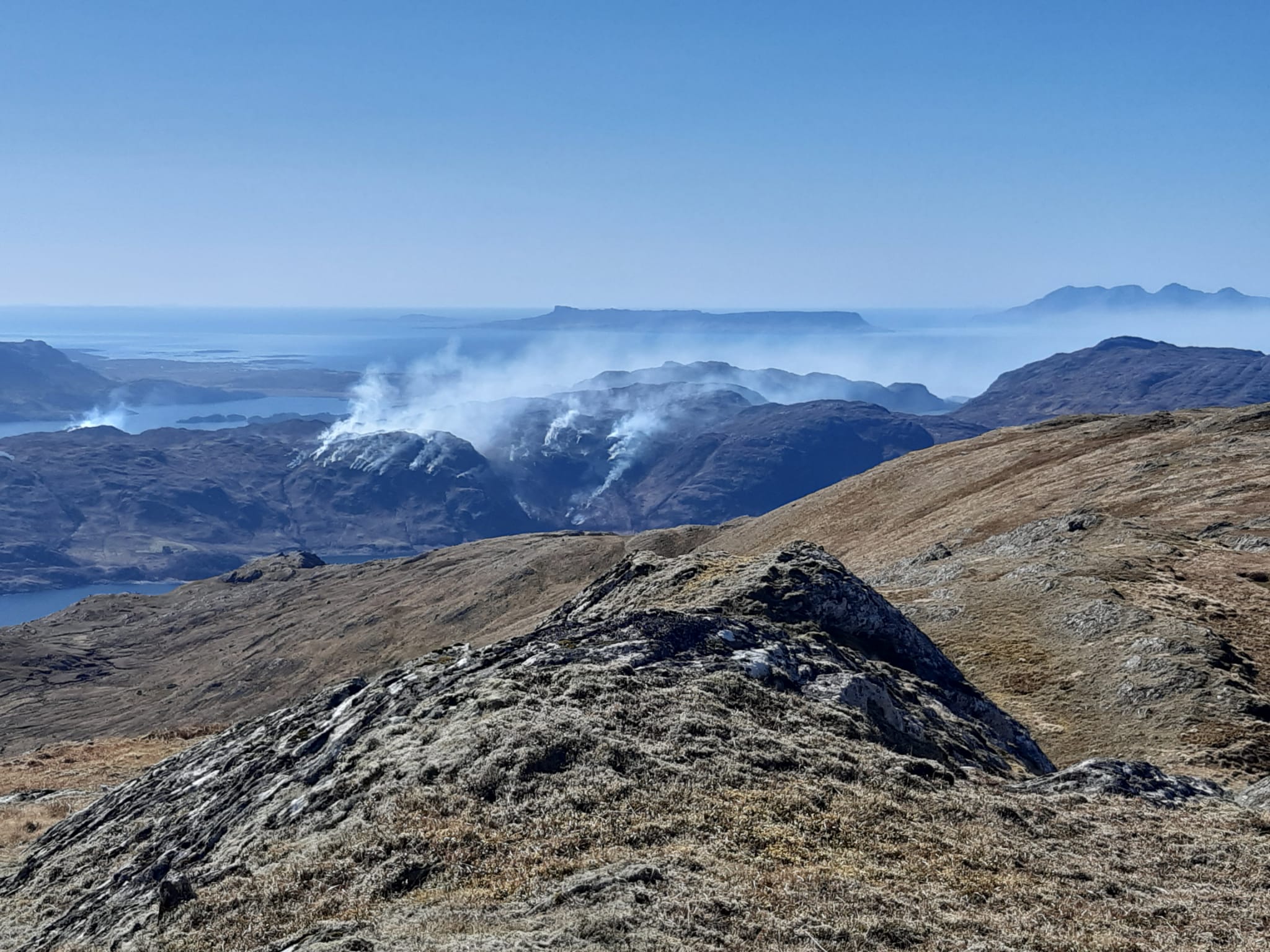
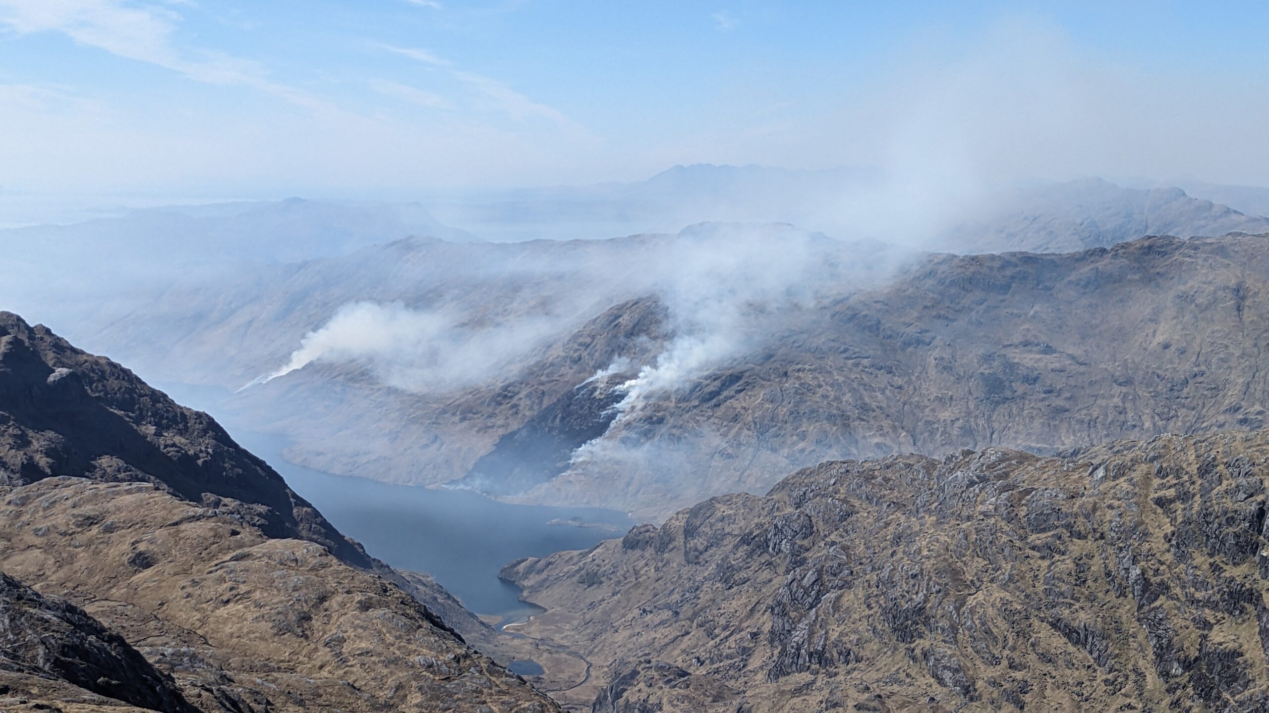
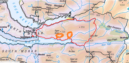
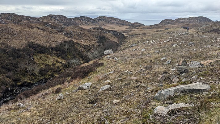
Saturday was a fantastic day but there had been a few small clouds over Loch Arkaig and when I glimpsed a puff of white behind An Stac I gave it no further thought. Thirty minutes later I turned again to see the lines of fire in the top photo spreading out and up the hillside on the north side of Loch Morar.
Last year out of control muirburn on North Morar (see here) and (see here) had burned for three days between 2nd and 5th April. The wet start to this year has meant those responsible have not been able to set the hillsides aflame so early. Forced to delay, this muirburn was outside the prescribed season which ends on 15th April but can be extended to 30th April with the permission of the landowner. The Scottish Government has not encouraged this, ‘as there are increased risks to ground-nesting birds in late April’. It has, however, delayed implementing the provisions in the Wildlife Management and Moorland (Scotland) Act 2024 that would make muirburn unlawful after 1st April for another year.
According to Who Owns Scotland the owners of the North Morar Deer Forest are the Trustees under Settlement between Ian RS Bond, Caroline L Bond & Harry PS Bond. It would be interesting to know if they authorised these two fires or not.
If not, those lighting these fires would be guilty of committing a criminal offence with a potential fine of £5,000.
In my view deliberately lighting fires at times of high fire risk should be subject to criminal prosecution anyway. As the Scottish Fire and Rescue Service (SFRS) Head of Prevention and Scottish Wildfire Forum Chair, Deputy Assistant Chief Officer Kenny Barbour, said put it in their news release:
‘Wildfires have the potential to destroy property, landscapes and wildlife, which is why it is so important that members of the public use extreme caution under these conditions.’
The SFRS extreme fire risk warning is notable because, once again, it is only directed towards the general public and not those who manage areas like Morar.
Four hours later I was on the summit of Sgurr Thuilm and the nearer fire appeared to have reached the top of the ridge on Sgurr Breac (728m). The Muirburn Code says this about ‘Summits, ridges and other areas very exposed to the wind’:
- ‘These areas should not be burnt, as vegetation is kept short by high winds (wind-clipped); burning has no benefit and risks removing vegetation cover, leading to erosion.
- These conditions are most likely to occur:
- Above 300 m in the north-west,’
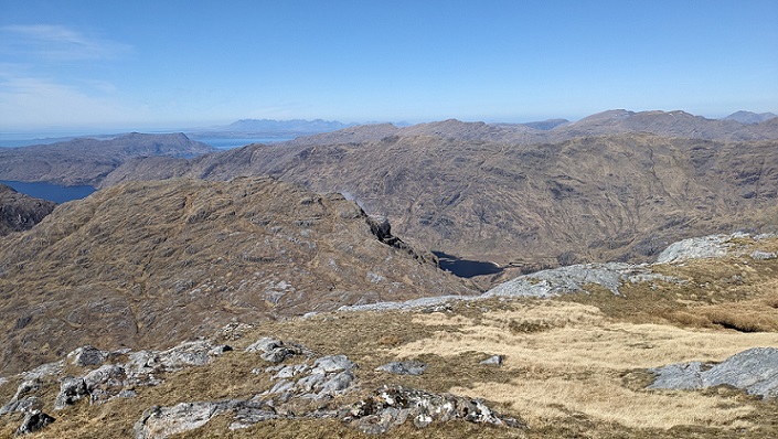
I caught a few whiffs of the smoke as it spread down Glen Pean but the main pall of smoke was spreading north towards Knoydart. I felt very sorry for people stopping off at Sourlies, the popular halt for walkers of the Cape Wrath Trail, as I guessed they would be enveloped in smoke. It is also criminal offence to create smoke that is a nuisance.
The next day, further east on Streap, I could see no signs of smoke. It seems likely the fires burned themselves out when they reached the ridge as generally they spread more easily uphill than down.
The impact of muirburn in North Morar
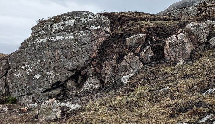
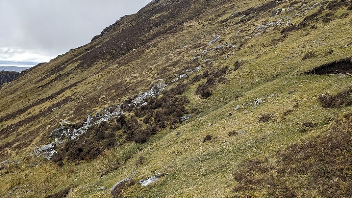
A few days earlier, on a separate trip, I had walked up Carn a’ Ghobhlair, the prominent hill at the other end of North Morar behind Mallaig. This was on land that is owned by Nevis Estates Ltd and crofted. Close to the road the moorland was being invaded by rhododendron but after that much of it had been burned:
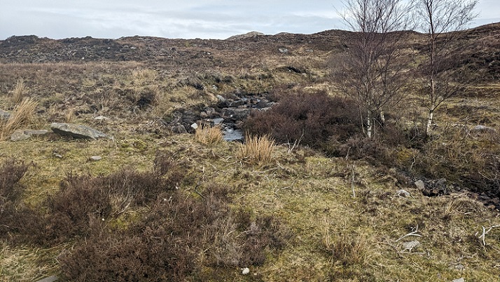
We used a couple of long rakes to thread our way up the rocky west face:
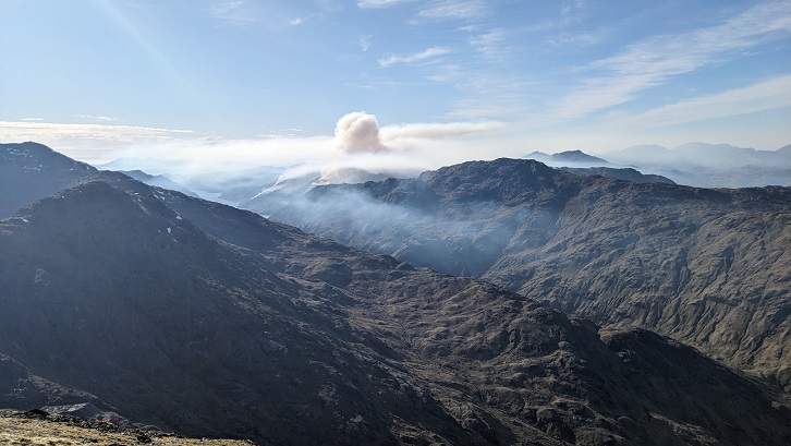
Much of the face had been burned not so long ago and the ground was a lot wetter than I found it a few days later.
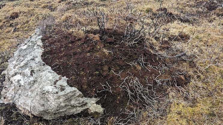
It probably would have been wetter still if so much moisture retaining vegetation had not been incinerated.
The impact of fire on vegetation was greatest along the rocky sides of the rake where fire had burned lichens off boulders and exposed the underlying soils.
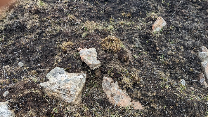
These areas of soil exposed by the fire are now prone to erosion by water and, where peaty, to oxidisation.
As the SFRS said in 2021 when commenting on another fire in Morar (see here):
‘These fires can also have a hugely negative impact on the environment and the release of greenhouse gas emissions into the atmosphere.’
All this destruction so a few more sheep can be grazed on the land
.
Muirburn and crofting – the political problem
From an environmental perspective, burning the natural environment to improve grazing for sheep or deer is highly destructive.
The fire I witnessed on 25th April could have been intended to improve grazing for either sheep or deer – I have been unable to establish if any of the land in the North Morar Deer Forest is subject to common grazings or not. Whatever the case once the Muirburn Licensing scheme is implemented, it will no longer be lawful to burn for deer. That will be half the problem solved.
That leaves the question of burning by crofters to “improve” common grazings. .Even on the better ground, the number of sheep that can be supported through burning is not great. The problem is that to the crofters sheep represent a source an income, there are no alternative means of earning a living from the land and therefore every extra sheep counts. The crofters have little choice about what they do, unlike the very rich people who burn the land so they can shoot more grouse.
This helps explain why parts of the West of Scotland, like Morar, are like the wild west when it comes to muirburn. It also helps explain why local people are so reluctant to complain and why public authorities are so reluctant to take any action to stop this destructive activity even when it is clearly unlawful. No-one wants to be accused as being responsible for new clearances. The result is that most fires caused by land managers on the west are unreported unlike those caused by the general public.
The precarious position of crofters may also help explain why in 2007 those on North Morar refused Cameron Mackintosh’s offer to sell much of the land he owned through Nevis Estates to them (see here) while later opposing his application to ‘resume’ some of the crofting land to expand native woodland (see here). If the only potential source of income from the land is sheep, there is no point owning it but also any lost grazing means lost income.
In theory carbon offsetting could now provide crofters an alternative source of income to sheep and help stop the burning. Relying on markets to do that however is not the sort of risk that those dependent on the land wish to take. They need greater security than that, a guarantee from the state of future income for managing the land in a more sustainable way. That requires land reform. Unless and until that happens, either the Muirburn Code will continue to be flouted on parts of the west coast or there will be major political fall-out as enforcement action is taken against people who have little choice.

It’s not really got anything to do with the Muirburn code – as its the law that you cannot burn after 15th April (22nd on high ground) without a special licence from NatureScot. They should initiate a prosecution if there was no special licence in place.
Next year its a unified close date of 31st March.
Hi Colin, but the law is set out in the Muirburn Code which states: ‘Muirburn is permitted only during the statutory muirburn season, which runs from 1st October to 15th April inclusive, but the season can be extended to 30th April, with the permission of the landowner. The Scottish Government does not encourage this extension, as there are increased risks to ground-nesting birds in late April.’ That section of the Code goes on to say ‘In a small number of exceptional circumstances, burning outwith the season can be applied for. See the NatureScot website for guidance on an out of season licence.’ My understanding therefore is in this case there was no need for whoever set the hillside alight to seek a special licence, only to get permission from the landowner. You are right though that next year there should be a unified close date on 31st March.
My understanding is that until the 2024 Act is in force and the new updated Muirburn code agreed, in the period between 15 April and 30 April landowner consent is all that is required; and currently it is only from 1 May in each year that a licence is required from NatureScot.
The new Act will however, once in force, create an offence which on conviction can lead to imprisonment for a term of up to 6 months or a fine of up to £5000 (or both).
On April 15 last year a huge wild fire took hold just south of Kentra bay beside Acharacle, Ardnamurchan. It was only finally extinguished within the outskirts of the village 60 hours later.
There is no detailed explanation for how it began, ..no one today grazes livestock on that hillside anymore. So,apart from historic glass among flattened wind-dry vegetation which refracted sunlight as the wind changed direction, the cause seems most likely to have been old broken glass left by people fishing one larger Lochan.
The small fire ignited just a thin coloumn of smoke. But then expanded as teh wind changed direction many times. It could quite easily have been contained that first hour, if the proper resources other countries do deploy were available in Lochaber to do this. There are several other small lochans nearby from which water could have been lifted, had a helicopter ( which arived eventually) been made available sooner
While devastating to watch, as it spread out of any control, within a few short weeks the burned areas were no longer easy to spot. Fresh spring time vegetation soon “greened” the hillsides again.As I look towards it just now the patches of old growth trees under which the fire swept through, are again in leaf. And Ihestitate to say, the village of Acharacle is probably safer now than if that April 2025 fire had never happened.
hi Tom, what do you think happened to any regeneration of trees and shrubs in the vicinity or within the old growth? Are you pro-burning?
I suggest you might even go up and take a look. and with regard to your otehr question. I am a realist..
On a hot dry day such as this region has seen this past week, many years ago high on a hillside I made my way to where a small patch of smoke had appeared. When I got up closer I noticed a frond of heather had been rubbed in the strong wind against a birch sapling until it began to smolder. Does that answer your question ?
Wild fires are a force in nature. A lot mysterious burns occur along this peninsular every year, yet there appears to be absolutely no malice involved. Old bottles, once “Shepherd fuel (!) or used to carry dosing for livestock …once drained these containers have been discarded down the decades – they lie partly concealed now within deep vegetation, they never rot and may be almost anywhere.
I too am a realist, and the annual cogent deliberate burning to suit the sectional vested interests of the sheep and grouse industries in no way replicates or mimics any natural fire cycle that may pertain in Scotland. Discarded shepherd fuel bottles are just another manifestation of an industry that was fundamentally inimical to Highland culture and is still disastrous to the successional processes of the soil-vegetation complex. Our upland landscape is little short of a sheer utter disgrace.
The 1946 Hill Farming Act which governs muirburn has an above 1500′ limit which permits burning here after the 15th April. Section 23 Subsection 2. Not quite sure if burning above 1500′ after this date also requires landowner consent.
Equally i’m not sure what changes there have been since the 1946 Act – some 80 years ago – to ensure that legislation meets today’s societal needs. Useful to set out in simple terms what the incoming muirburn licening will require , so the public are better aware.
Once more it comes down to a complete lack of a strategic landscape management paradigm based in any form of biological concept of sustainability. Then, of course, we have the systemic inertia inherent in the Holyrood ‘thwartocracy’ combined with the apparent prevarication, procrastination and simple disinterest of the Holyrood politicos ( including the Greens and SNP) in doing anything about it. Needless to say deeply rooted in the problem is the influence of sectional vested interests in the land monopoly hegemony and of course the crofters who share the pyromania fetish.
just noting this — a few years ago, on Loch Morar – I noted fires on the northern hillside ( probably in May in fact). they were – as your pics show – in remote gullies and high on the hill. But I could see no reason why anyone would or could intentionally burn these localised and remote areas and assumed that they were – as previous person noted – caused by other means. Of course i do not disagree that these fires are disastrous to vegetation and wildlife ( what little there is); but remain unconvinced that they are are caused by human intent.
So yet another fire on North Morar – why would there be so many in one small area?
It would be interesting to know if fires did take place after 15th April in CNP or elsewhere on genuine heather moorland? So were people following the advice? Is there satellite data?
All the people I know have always stopped after this date as after that the ground nesting birds are down from late April-early May.
I am reminded of that old Scots song ‘Graze,Burn and Kill As Ye Gang Alang The Hill’
The extensive smoke plume from the 25/4 Morar fires was clearly visible from Rum extending north over Knoydart and Glenelg peninsulas. I subsequently looked up the MODIS/SENTINEL satellite data on active fires and burnt area available via the European EFFIS project.
Unfortunately I cannot seem to post an image here but there does indeed seem a pattern for North Morar with previous fires in 2025, 2023, 2022, 2021, 2019. As the pattern seems to be on land of very constrained agricultural capability (ie.LCA class 7) not sure that I see a clear link with productive sheep grazing, although previous experience also suggests sometimes different (symbolic?) factors are involved at local level.
Well Iain, that’s a very diplomatic ending paragraph. Perhaps, ingrained cultural pyromania, might be another way of putting it.