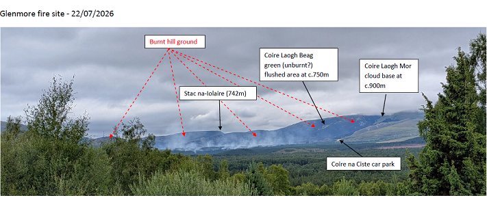
There is (currently) no public access to the Glenmore / Ryvoan fire site (Cairngorms National Park Authority Update 17.00 on 23rd July see here), and restrictions to the area are unlikely to be lifted before next week (CNPA Update 21.00 on 22nd July (see here) . Therefore, this annotated photograph (from Whitewell, c.10km away) may be of interest but, with a flare-up reported later yesterday (see here) the damaged area may now be greater than previously reported.
Open hill ground was burnt up to c.900m altitude (possibly higher). On the right (south) side of the photo, the fire extended to the foot path up the ridge on the east side of Coire na Ciste.
The photo does not show anything of the fire area within Glenmore Forest itself.
The fire started over the skyline on RSPB ground. There is a short video by Ronan Dugan (Wildland) (see here) that gives a glimpse of the extent of the fire in Strath Nethy. It extended southwards as far as OS grid square NJ0206, level with Bynack Beg and Coire Laogh Mor.
RSPB, Forest and Land Scotland, Wildland, other estates and volunteers, plus Agencies have understandably been giving and continue to give their full attention to tackling the fire. Hopefully, in due course, an accurate map will be published showing the extent of the fire.
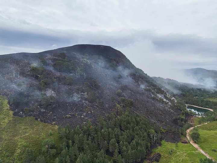
An assessment of the impacts of the fire will have to wait until fire suppression is completed and there is access again. There is a lot of pre-fire survey data, e.g of tree regeneration, flowering plants, mosses and liverworts, and it will be informative to learn what what survived. Amongst boulders and scree, and in flushes I would expect (hope) that quite a lot will have survived. Within the forest, I would expect impacts will vary a lot, depending on age and density of the trees and the type of field layer in the woodland. It appears that within the area burnt on the east side of Ryvoan Pass, many (most?) of the old pines have survived the fire, which is very encouraging.
It has been suggested that the fire burnt c.10km2 before the flare up last night. That looks to be approximately right. 10km2 is 1.7% of the whole Cairngorms Connect area and c.0.2% of the whole Cairngorms National Park. So a very big fire, but in the context of the wider landscape, perhaps not a disaster although extremely tough for those still trying to extinguish it.

Nice succinct and informative post that hopefully will set up a wider discussion on the damage/ recovery process and what we might expect afterwards. I might try and make a contribution to that myself.
If not already avilable certainly interesting to plot locations and extent of past large fire events in and around the CNP. Dava Morayshire at 96km2 in 2025 is the largest overall and partly in the CNP. This current Strath Nethy fire in 2026 at 10km2 being large too. Blackmount 1976 perhaps 4km2, Glenmore 1960 was 6km2 , Loch an Eilein 1899 4/5km2. I’m sure there were others. I can think of Glen Tanar 2018 0.75km”, Rothiemurchus Lodge 2020 0.05km2, Glen Lui 2014? 0.05km2?
In Canada simulated wildfire modelling ( Prometheus programme) is done because of threats to life and limb and ecology and because of the many millions of dollars worth of vulnerable property. Jasper, in the National Park of the same name, is similar in size to Aviemore and the 2024 fire here destroyed one-third of the town’s structures, causing an estimated $1.23 billion in damages.
In the CNP we have good ground cover data, terrain elevation, slope angle models, weather records, recreation and land use distribution patterns. This should all support quite realistic wildfire scenario predictions. Maybe it would give the winter avalanche reporting teams a year round job and contribute to faster reporting and more effective and effcient use of scarce fire extinguishing resources.
Taking a quick measure using the satellite imagery from yesterday on the Copernicus browser (For those interested: https://browser.dataspace.copernicus.eu/) I come up with about 10km2 burnt, so this figure looks to be correct barring whatever additional damage the flare up has caused. It looks to be mostly confined to the open hill although some areas have progressed 600-700m (best estimate due to smoke obscuring the image) into the woods east of Loch Morlich. Occasional fires are a natural part of the ecosystem here, which is not to play down the severity of the damage but hopefully means the area will recover well with time. If there is reasonable seed source in the soils around the veteran trees on the east side of the pass then the removal of competing vegetation might even allow for increased regeneration of native Scots Pine in these areas. Hopefully something better can come back from the ashes.
Now appearing on the BBC, but today there is smoke and a horrible burning smell in Aberdeen and has been most of the day. We have had to close all the windows at work. Hate to think what my 15mile cycle home from Foresterhill is going to be like. It seems like a very long distance for the smoke to have travelled, but it clearly has!
I am concerned about the comments playing down the severity and size of this wildfire. Despite the platitudes of SFRS and the Scottish Government it is clear that this wild fire is far from being contained, especially given the high winds blowing from a westerly/south-westerly direction today. Viewing from Grantown this afternoon, I estimate the massive smoke plume was rising 10,000-20,000 ft. Also, this evening, I’m hearing that as a precautionary measure Nethy Bridge is being evacuated. This wildfire has a long time to go before it is under control, despite there being some rain forecast.
Yes, it will be interesting to study nature’s recovery as we are seeing on Dava Moor, but let’s not play down the eventual size and severity of this wildfire and its environmental and human impact.
Hi Gordon, you are absolutely right that there was very little basis the claims from SFRS and Scottish Ministers that the fire was under control but, with rain forecast it did look early on Friday that the fire would at last be extinguished. What I completely failed to anticipate was the effect of the wind that came in before the rain. The key point here is whatever the extent of the ecological damage now, wildfires once they get going are very hard to put out without help from nature in the form of rain, which is all the more reason why the Scottish Government needs to resource SFRS to deploy helicopters to put out fires before they get established. Blaming climate change for these fires shifts responsibility from government for resourcing the fire service properly – throughout this saga as you have pointed out the SG have claimed there have been sufficient resources to fight this fire. That is clearly untrue
it is an adequate response from government but completely in phase with an inadequate national park structure in the first place.
Ron Summers book on the history and ecology of Abernethy Forest has an interesting section on previous fires in the forest. Fire experiments were carried out by the RSPB in the early 2000s. Once an area had been burned it took a few years before a good fall of seeds from the mature surviving trees or those nearby not burnt but when a good fall did happen recruitment of seedlings on the burnt plots was almost 10 times that on the non burnt plots. So there is some hope.
Just one comment – lesser in scale and sweep that those so far. I am not well informed at all on the extent of the damage within the Ryvoan gorge etc but holly was once a widespread species within the Old Cali Forest but now there are only two stands of it left in the whole eastern highlands.:One is in Birse but the only one within the main Cairngorms area and within the National Park is in Ryvoan. I hope no great damage has been done to this population. There is or was a small scattered, heavily grazed population on the slopes on the SW bank of Loch Muick but the last time I checked it it had shrunk.
Hi Drennan,
Most of the recorded location for Holly in Ryvoan Pass are on the NW side, which as far as I can ascertain, has not been burnt.
With reference to your comment that “holly was once a widespread species within the Old Cali Forest”, I am not sure that was the case. A study in Denmark (Iversen, 1944), summarised in Peterken, G.F. & Lloyd, P.S. 1967. Biological Flora of the British Isles. No. 108. Ilex aquifolium L. Journal of Ecology 55: 841–858 doi:10.2307/2258429, found that Holly was absent from areas where the mean temperature of the coldest month falls below -0.5C. The distribution of holly is also affected by the mean temperature of the warmest month; it is absent from areas where this does not exceed 12C. In Britain, holly is not found naturally in those areas where the July mean temperature does not exceed 12.8C.
I created a map showing the recorded distribution of Holly at the tetrad scale (2 x 2km grid) for Scotland (here). Holly is mainly found at lower altitudes and is largely absent from most of the interior of the Highlands, e.g. the Cairngorms. With a changing climate this distribution may change over time.
Within Abernethy Forest, Holly has been recorded from 41 100m grid squares, mainly south of Forest Lodge. From memory most (all?) of these are quite young trees. Holly is bird dispersed, and can potentially appear wherever birds deposit seeds in their droppings. It may be that with reduced deer numbers and less severe winters, holly is starting to colonise the forest.
Aye, Drennan a point well made. We tend to forget about Holly and its role in the forest. Because of the waxy coated leaves and prickly lower branches we tend to overlook its palatability( hence the defensive prickles) and value as a food source to large herbivores. It’s leaf litter is a highly biodegradable source of food for invertebrates and important in soil formation. Its importance for birds is obvious in terms of berries food and nesting habitat. It is of course quite shade tolerant and can even form stands in open Beechwoods. Sadly, it is highly vulnerable to fire damage and hence I share your concerns. I’ve noted their presence at Loch Muick and it makes you think that they were probably far more abundant and extensive in the past. I’ve even postulated that the Trossachs area( in Gaelic ‘the bristly country) got its name from their abundance locally.
Scot Gov statement 25 July 22:06 (https://www.gov.scot/news/progress-in-tackling-cairngorm-wildfire/)
“Two helicopters have each been dropping between 20,000 and 40,000 litres an hour on the areas affected”
So these 2 small commercial helis have been doing amazing work using just 1000L / 1mT water bags.
Hence approx 3-6mins/run for each 1mT load
Just imagine then the impact that a Chinook capable of around 10000L / 10mT per run could make!
(even if possibly a little slower and less nimble per run)
After Dava and now Cairngorm, surely it is time to negotiate and put in place agreements and structures for military call-out that are then ready and waiting-on-the-shelf for the inevitable next fire. SFRS should be screaming for such arrangement in their lessons-learned review following this incident.
Ian, I think you are confusing capacity- amount carried- with capability. The pilots flying these smaller helicopters are experienced and trained for the job. Not saying it can’t be done, but would need modification of people and equipment.
Barrie
No, I am not confusing these, but do agree entirely on the need for mods to military people and equipment. (which is why they could not suddenly jump in to assist with this fire) However, getting prepared and being ready is just a UKGov, ScotGov and Military management choice!
Chinooks are based in S England but regularly visit Moray for tactical and low flying training in the mountains.
They can and do carry heavy eqpt, vehicles and field guns etc underslung. With up to 10mT lift capacity.
What they almost certainly don’t have is 10mT water bags and associated kit ready to go, or the experience of using such. But surely not too far to suggest that suitable eqpt could be arranged and put in tactical store.
Pilots already hugely skilled in underslung load transport would surely not require a huge amount of familiarisation to add water bomb capability to their skill set! It could be managed as a natural extension of their other military flying skills via training and exercise.
This is all about planning and preparation in order to have such a response contingency ready to go.
The key point is the “management” willingness and desire to put such a programme in place. It could all be done (and at relatively small real additional cost)
What doesn’t work, or make any sense, (apart from political game-playing) is for ScotGov to suddenly ask UKGov for military assistance on day 12 of the fire!!
Just to add confirmation that RAF Chinooks and pilots can and do use Bambi buckets for water bombing:
https://www.facebook.com/rafodiham/videos/raf-chinooks-deployed-to-support-wildfire-response-in-cyprus/1071256778402088/
If they can be deployed for such in Cyprus, clearly they also COULD be in UK – just requires our various leaders to want to, and decide to, actually do so.
Great information Ian, the more you learn the more dysfunctional government, at both the UK and Scottish.level, appears
RAF Odiham
13 June 2025·
RAF Odiham Chinooks Deployed to Support Wildfire Response in Cyprus
In recent weeks, RAF Odiham Chinook helicopters from both 27 & 18(B) Squadron have been deployed to RAF Akrotiri, Cyprus, to provide Aerial Fire Fighting (AFF) support to combat wildfires across the island.
This deployment follows the successful completion of Exercise PYRSOS – named after the Greek word for “flame” – an annual validation exercise with the Republic of Cyprus Firefighting Service.
Why this matters:
✔️ First-ever use of Chinooks in this firefighting role
✔️ A dedicated RAF detachment with underslung water buckets
✔️ Close integration with Cypriot and international firefighting agencies
✔️ A forward logistics hub at Akrotiri for rapid and sustained operations
“This deployment underscores the Chinook Force’s versatility and the RAF’s commitment to supporting partners during times of crisis,” said Air Vice-Marshal Simon Edwards.
As wildfires become an increasing threat across the region, the RAF’s presence enhances the UK’s support for environmental resilience and emergency response across NATO and allied territories.