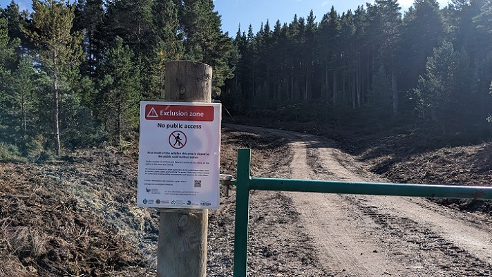
The creation of access rights under the Land Reform (Scotland) Act 2003 did not remove restrictions on access made under other legislation. Some of those legal restrictions apply to land more or less permanently, such as those applying to working quarries, but some are more temporary. For example, under the Fire and Rescue Services Act 2004 the Scottish Fire and Rescue Service (SFRS) may, in the event of an emergency, restrict access to premises or a place in the interests of public safety.
SFRS’ initial response to the Abernethy/Glenmore wildfire (see here) was to close some roads and advise people not to enter the area but by 16th July this had become a strict cordon (see here) . Buildings in the area then started to be evacuated. While there is nothing in the various news releases from SFRS explaining the legal basis for these measures, there is little doubt they had the power to do so under the 2004 Act.
While the fire was almost extinguished by 23rd July (see here), the wind then got up and changed direction. It was another week before the wildfire was brought under control and SFRS announced a phased reduction in its statutory Exclusion Zone on 30th July (see here). It is worth noting here that the Nethy Bridge evacuation, unlike the evacuation of part of Glen More, was only advisory, just like SFRS’ initial advice to the public to stay away from Ryvoan.
On 17th August SFRS finally left the scene and handed back responsibility for monitoring and controlling any further outbreaks of the fire to land-managers (see here).
As well as offering advice, SFRS clearly had the power to close the area affected or put at risk by the wildfire during this period and the justification for doing so was clearly very strong. The risks to the public were very high and the presence of the public could have interfered with fire fighting operations.
The Exclusion Zone, however, was continued by the Cairngorms National Park Authority (CNPA) after SFRS had left the scene.
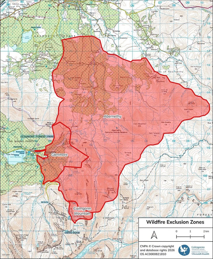
The red area on this map covers a far wider area than was affected by the wildfire, as you can see if you compare it with the mapping undertaken by Andy Amphlett using satellite data (see here). As examples, large parts of Abernethy forest (top of red area), Geal Charn and the route to it from Dorback (right of red area) and the higher part of the Cairn Gorm plateau above Strathy Nethy (bottom of red area) were never burned. There appeared to me no justification for trying to exclude people from these areas so I emailed Grant Moir, Chief Executive of the CNPA, on the 19th August asking the legal grounds for doing so and the justification for this. He replied promptly the next day.
The legal grounds for the CNPA’s “Exclusion Zone”
Grant Moir’s email explained the legal basis for Exclusion Zone was Section 15 of the Land Reform (Scotland) 2003 (“the Act”).. To give the CNPA credit, while I could not find a reference to this on their website, it was clearly stated on the signs I saw when I visited Glenmore on 23rd August (see here):
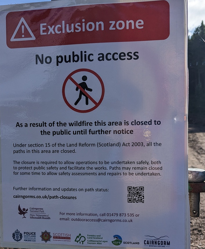 Section 15 of the Act is titled ‘Measures for safety, protection, guidance and assistance’. It is predominantly about empowering access authorities, such as the CNPA, to facilitate access by the public, by doing things like installing gates through fences and providing public toilets, so as to enable people to enjoy access rights.
Paragraph 1, however, empowers access authorities to dissuade the public from exercising our access rights where there is a danger:

The key point about this paragraph is it applies to “land in respect of which access rights are exercisable”. It does not suspend access rights. Rather sub-para (1)(a) gives access authorities the power to erect warning signs while sub-para (b) gives access authorites the power to erect fences (“enclose”) around dangers (examples might include sinkholes or open mine shafts).
Unfortunately, what is meant by “giving directions” in sub-paragraph (b) is far from clear and is not defined in either the legislation or the accompany guidance (see here). Nowhere in the Act, however, is there any power for an access authority to stop or punish any member of the public who decides to ignore warning signs, climb over fences erected around dangers or chooses to continue to exercise their access rights in the fact of “directions”.
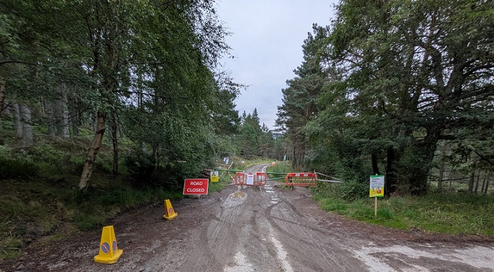
Moreover, there is no reference to or use of “Exclusion Zones”, a very strong term which implies access rights do not apply to an area, in the Act. In continuing to refer to an “Exclusion Zone” around Abernethy and Glen More, therefore, the CNPA appear to be acting beyond their powers (“ultra vires”).
Many people reading the signs will assume from the reference to Section 15 of the Land Reform (Scotland) Act 2003 that the attempt by the CNPA to create an Exclusion Zone is founded in law. It is not and in effect the CNPA are unilaterally undermining access rights by trying to introduce a new type of restriction.
The CNPA’s justification for trying to exclude people from the Abernethy/Glenmore wildfire site
Under the legal framework created by the Act and the accompanying Scottish Outdoor Access Code (SOAC), it is legitimate for Access Authorities and indeed land managers to advise the public not to exercise their access rights in certain areas or at certain periods for specific reasons. Most of these are described in SOAC with the key underlying principle being that such advisory “restrictions” should be kept to a minimum.
In my view, there was never any justification for trying to exclude people from a wider area than was burned by the wildfire once SFRS had left the scene and the risk of the fire spreading elsewhere was judged to have ended. I pointed this out to Grant Moir and around 28th August the CNPA reduced the size of their “Exclusion Zone” (as shown on their web page on path closures (see here)) .
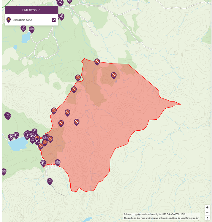
Among the unburned areas removed from the CNPA’s non-statutory “exclusion zone” were the walk up Geal Charn from Dorback, the Ciste car park and the tracks north of Forest Lodge. However, some unburned areas, such as on the east face of Meall a Bhuachaille above Ryvoan bothy, and the area south of Geal Charn remain, according to the CNPA out of bounds:
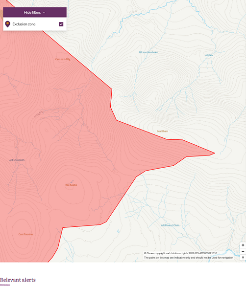
The lifting of these “restrictions” were not announced in any news release and the CNPA and the land-managers involved gives every impression of dragging their feet in respect to lifting the restrictions they are trying to impose on the public. An example is a post which appeared on the RSPB Loch Garten facebook page a few days ago which stated “Some areas may remain closed for some weeks/months due to the substantial safety work that needs to be undertaken”.
Grant Moir provided me with three justifications for the CNPA’s “Exclusion Zone”: the potential danger to the public posed by damaged trees; continued work on site including the use of heavy machinery (to remove damaged trees and to tidy up the work associated with creating new tracks and fire breaks to control the fire); and the fact that fire was still smouldering in a few places.
The risk posed to the public by fire damaged trees
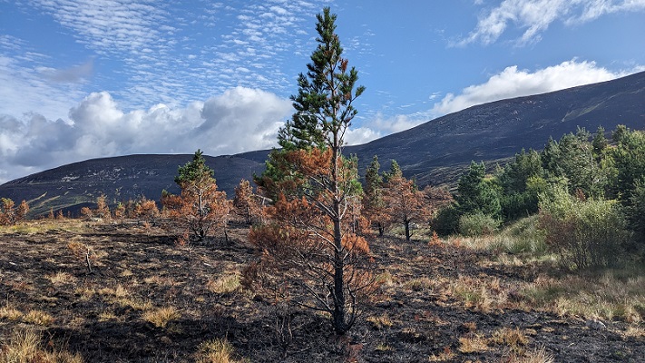
The majority of the site affected by the wildfire was not forest but heather moorland and above that the montane zone. While trees had been spreading onto moorland through the RSPB’s planting in Strath Nethy and through natural regeneration, most of these trees were small, the dangers obvious and easily avoidable, as can be seen from the photos of the damage around Coire na Ciste:
The only areas within the so-called “Exclusion Zone” where there could be any real risk of falling trees is in the core areas of the Caledonian pine wood in Abernethy and Glen More. However, photos from the parkswatch reader who ran into Ryvoan suggest that a significant proportion of the trees immediately beside the track were cleared in order to create a wider fire break:
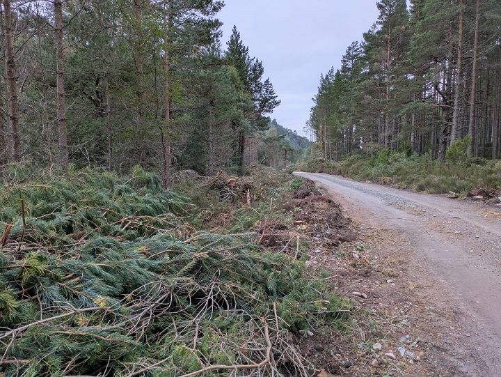
and that where trees had been burned the dangers were both obvious and not that significant:
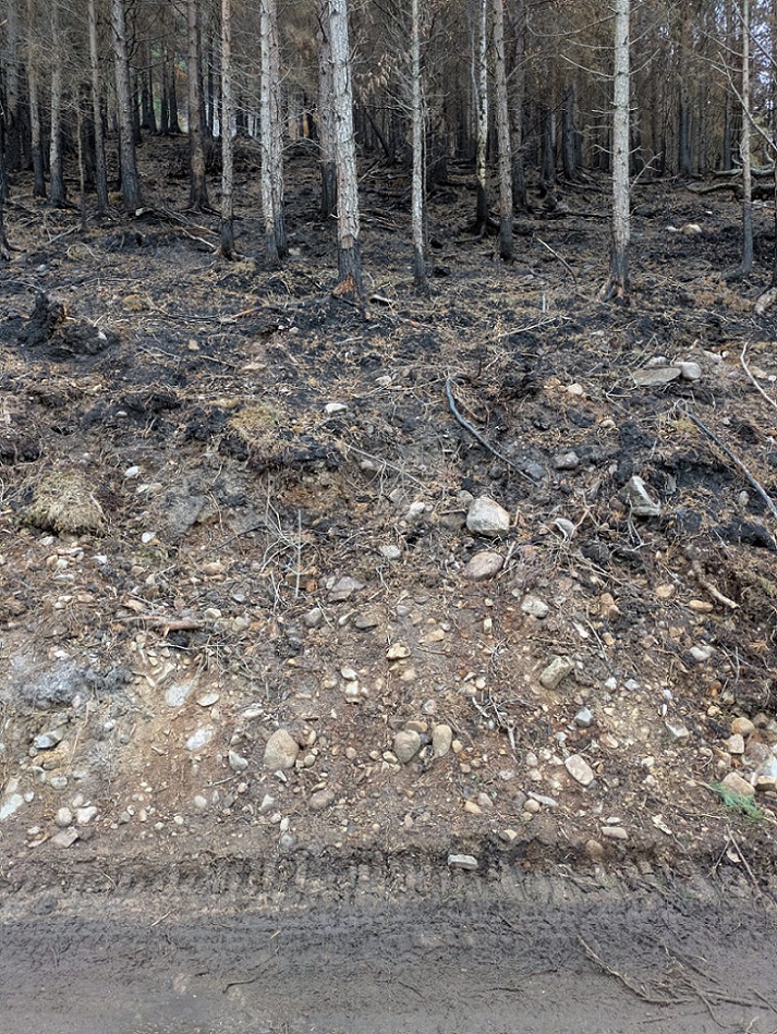
While the CNPA’s and land managers safety concern appears to be that trees whose bases and roots have been severely burned could topple and potentially injure the public, there now appear to be relatively few such trees close to the track. The person who took these photos, an experienced hill goer, saw very few obvious signs of danger along the track to Ryvoan, with the exception of tree-lined Lochan Uaine, a popular visitor spot. Perhaps the dangerous trees had already been removed but, if so, why such a large “exclusion zone” and why not just limit this to Lochan Uaine?
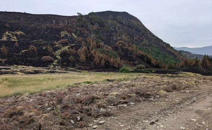
Beyond the core forest area, i.e over most of the “Exclusion Zone”, the danger posed by damaged trees is almost non-existent.
I have heard that the RSPB have rightly stated that they do not intend to fell fire damaged trees away from tracks. This means that anyone walking off track in the 10% of the core Caledonian pine wood at Abernethy affected by the fire.will have to use their judgement to assess the risks posed by fire-damaged trees. That is not a problem is just what people should do with any other natural hazard.
It is also worth noting that RSPB has in the fairly recent past ring-barked planted Scots pine at Abernethy in order to try and create a more natural forest and that, as far as I am aware, the CNPA has never made any attempt to exclude the public from these areas raising the question of what is the justification for trying to do so now?
The need to carry out management operations after the wildfire and the associated risks
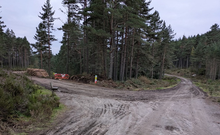
The need for both RSPB and Forest and Land Scotland, as owners of land most affected by the wildfire, to undertake management operations afterwards is not in dispute. Besides removing damaged trees, such work includes removing undamaged trees felled to create new firebreaks, tidying up new tracks and checking for new hazards that could have been created in the course of fighting the fire. It is also accepted that because of the effort staff from both organisations devoted to fighting the fire, many will have needed a well-deserved break and these processes might take longer than usual.
Almost all of these management operations, however, appear to be taking place in the forested part of the “exclusion zone” and do not justify the inclusion of large amounts of moorland within the “exclusion zone”. They could also be managed under existing frameworks for access during forestry operations which were designed to keep restrictions to the minimum possible, for example, by advising people only to avoid areas where machinery was actually being used. That framework enables people to continue to enjoy their access rights, without fear for their safety, at weekends or outside core working hours. It could now be applied, given a little will, to any continued forestry operations that are required as a result of the wildfire.
Unfortunately, the evidence suggests that the CNPA lacks the will when it comes to promoting this good practice and enouraging land managers to respect access rights. Instead of giving a date when the normal frameworks for managing forestry operations would resume, which would have focused minds at Forest and Land Scotland and the RSPB, its signs state the “exclusion zone” will continue “until further notice”. Almost five years after the CNPA first announced path closures in Glen Doll as a result of Storm Arwen, most of those closures remain in place (see here). That should serve as a warning of what could happen at Abernethy and Glenmore. Shocking!
The risks posed by smouldering fires
There is no doubt that where fire continues to smoulder in peat, the risks of a wildfire breaking out again remain high, as happened with the first fire at Dava Moor last year that was caused by a helicopter flare and which estate staff thought they had extinguished before it erupted several days later.
Such risks in Glenmore and Abernethy, while very high when the wind got up on 23rd/24th July, have subsequently been reducing by the day. To the extent that such risks still exist, the presence of the public could be a help rather than a hindrance. It was a hill walker who first reported the fire in Strath Nethy.
The argument that it is justifiable to try and exclude the public from moorland and peatland following a fire also sets a very dangerous precedent. Much of the Cairngorms National Park is intensively managed for grouse and subject to regular muirburn. Will the CNPA now start trying to exclude the public from grouse moors every time the land is burned? That would certainly suit grouse moor owners and managers who would prefer that the public does not see how they are managing their land. (For the latest raptor unlawfully killed in the National Park, a dead red kite found on Morven which tests show had been poisoned (see here)).
It is also worth noting that neither the CNPA nor Highland Council tried to impose any “exclusion zone” following the two wildfires on Dava Moor last year, the first of which started in the National Park. So what is the CNPA’s justification for trying to ban the public from such moorland now?
While those two fires predominately affected moorland they also burned areas of woodland within the Highland Council area. Yet Highland Council saw no need to restrict access to woodland – raising yet more questions about the justification for the CNPA’s “Exclusion Zone”.
Conclusion and discussion
While it was perfectly justifiable for the CNPA to advise the public to avoid certain routes and specific areas for a time after the SFRS left the scene (e.g where staff were still working to put out smouldering fires), from the evidence I have seen and gathered they have completely overstepped the mark with their “Exclusion Zone”. This has no legal basis, is at best advisory not mandatory and still still covers a far wider area than was ever necessary. This needs to be challenged by the general public and organisations representing recreational interests.
For routes and areas where it is still justifiable to ask people not to exercise their access rights, the answer is not a blanket exclusion zone but to follow existing good practice as set out in SOAC, with the reasons for any “restrictions” being clearly explained and limited in both time and extent.
Apart from some of the people involved (some staff in the CNPA appear never to have believed in Scotland’s access legislation) there are two underlying issues which help explain the CNPA’s disregard of access rights.
The first is a mixture of nanny state combined with management fear of being sued in the case of an accident, such as a fire damaged tree falling on someone. While Highland Council treated the public as adults last year after the Dava Moor fire, avoiding draconian restrictions, the CNPA appears incapable of trusting the public to be sensible and instead has tried to invent new regulatory powers in an attempt to manage these issues. The right thing for the CNPA to have done/to do now would be to advise the public that access rights are exercised at ones own risk and that following the lifting of the statutory exclusion zone, everyone should be aware of the various risks that remain.
The second is that the CNPA have long confounded access rights, which cover all land and inland water, with access along paths. Associated with this they have conflated the two different rights created by the Act, the right to cross land to get from one place to another and the right to enjoy land for a variety of purposes. That confusion is illustrated by the fact that that the maps of the “Exclusion Zone” (illustrated above) appear on the path closures page of their website.
The confusion has existed ever since the CNPA decided it was acceptable for grouse moor landowners to erect signs purporting to welcome people to the moor but then advising them to keep to the path (see here). Once an access authority regards access rights as being primarily about access by paths, then when there is a reason to advise people not to use those paths, its a relatively small step to advise people not to use the wider surrounding area. The converse was illustrated in a second email to me from Grant Moir in which he stated there was no point “re-opening” sections of track if sections further continue to be “closed” due to risks. My reply was that he appeared to be saying there is no point people being able to enjoy nature unless they are going somewhere. I have not had a response.
It is past time that CNPA staff acknowledged that people have a right to take short walks along tracks, step off those tracks to look at nature or have a picnic. Instead of closing whole tracks and vast areas of the countryside, all CNPA staff needed to do is erect signs stating where access along tracks or the wider countryside they are advising people not to exercise their access rights and then allow people to make their own decisions. It is time for the CNPA to start acting like an access authority, responsibly!
