Following my post on the proposed mountain coaster/toboggan run at Cairn Gorm (see here), I have been invited to meet Cairngorm Mountain Scotland Ltd (CMSL) along with Gordon Bulloch and Dave Morris who gave evidence to the Public Audit Committee with me about the funicular in January (see here). I have taken the opportunity to ask CMSL to clarify several matters relating to the documentation for the coaster planning application (see here) and to supply missing information.
Access Track
The planning documentation is less than clear about whether a permanent access track forms part of the application. There is no explicit mention of a track in the title of the application ‘Proposed mountain toboggan track and associated structures, buildings, platforms, landscaping and infrastructure works’ and no mention at all in the Planning and Design Statement which gives an overview of the proposal. A ‘maintenance and emergency track’ is listed as part of the development in the Landscape and Visual Appraisal (LVA) but its not mentioned in some of the accompanying visualisations.
That lack of clarity is compounded by the Construction Environment Management Plan (CEMP) produced by McGowan and Cnoclee Environmental Services which states under 2.1.1 Access:
‘Access to the route will be via existing roads / tracks where possible with access across open
areas being created using trackway panels or for low impact plant and vehicles.
All access which is not from existing tracks or trackway panels will be kept to required plant
and vehicles only.’
But then appears to contradict this under Section 4, ATV Access Track, which states ‘The works comprise:
- Earthworks to create track profile
- Formation of trackside ditch to control run-off
- Translocation of excavated turf to form verges and central strip to minimise visual
impact’. - The track shall be nominally 1.8m wide and 550m long. The track will be formed using local
site won material to minimise the requirement for imported material. Water bars and trackside
ditching will be installed to control any surface water run-off to minimise the risk of erosion.
Post Works
Completion of reinstatement once works are complete to ensure that appropriate
measures have been taken for future regeneration.‘
I would like to thank Mike Gifford, the CSML CEO, for confirming that a permanent access track does form part of the access application. It appears therefore that the CEMP was describing two separate things, temporary access for ATVs for construction purposes and a permanent access track for ‘maintenance and emergency’ purposes.
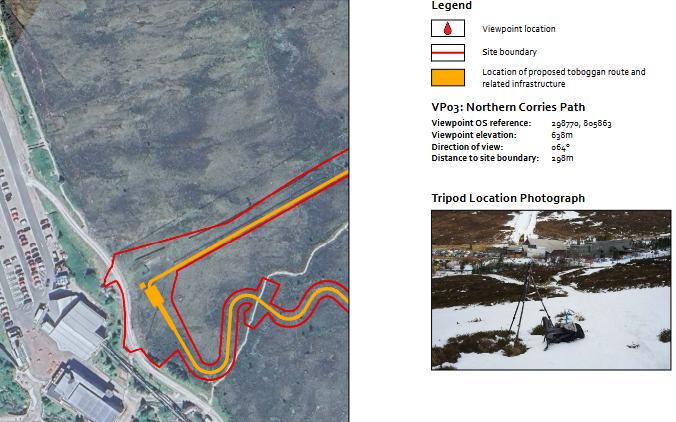
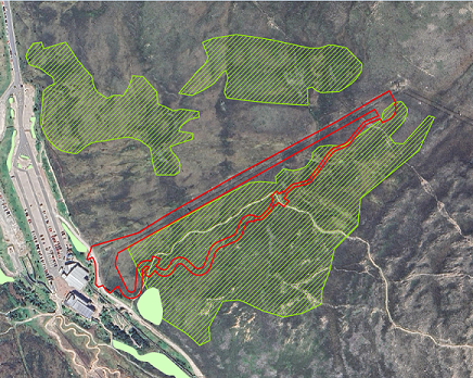
Just why HIE/CMSL believe its possible to construct the coaster without a track but one is needed for maintenance purposes is not explained. With Mike Gifford’s clarification I was able to work out that whatever the other documents state or show, the proposed Site Layout Plan appears to be correct (although the existing Poma lift is not clearly shown):
The Site Layout Plan shows that the proposed permanent track will be of very limited use for maintenance and emergency purposes because it would be separated from the longer downhill length of coaster track by the uphill coaster track which forms a barrier to vehicles. Since any accidents requiring emergency help are most likely on the downhill section of coaster track, the proposed access track appears to be in the wrong place. That raises questions about its real purpose.
The potential impacts of the proposed access track
The proposed track is 550m long and rises over 100m so the average angle of slope is around 1 in 5 or 20%. NatureScot’s Guidance on Constructed Tracks in the Uplands (see here) states:
‘Tracks designed to accommodate light four wheel vehicles should normally have a maximum gradient of 14% or 1 in 7.’
There is no mention that I can find in the CEMP or the other planning documentation of the angle of the track or that this would contravene NatureScot’s guidance.
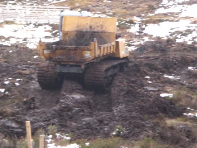
One of the consequences of constructing such a steep track is that it would be highly prone to erosion (see here). Evidence for that at Cairn Gorm is provided by what happened in 2019 to the easier angled track with water bars that McGowan had constructed alongside the Shieling Rope tow (see here). Both CMSL and McGowan therefore should know that installing water bars and ditching as proposed in the CEMP are extremely unlikely to prevent the track from eroding away.
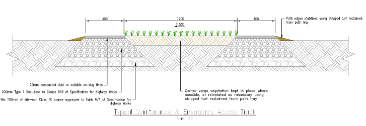
The CEMP provides a diagram of what it described as a ‘Typical Emergency and Access Track’. The width of the track in this diagram is 20cm wider than 180cm width quoted in Section 4 above. So which is it? That makes a difference to how visible it will be and how much material might erode away.
The LVIA states that:
‘The proposed maintenance and emergency access track would travel along the same route of the Day Lodge Poma ski lift requiring removal of heathland that is already partially subject to winter trampling, limiting the loss of prime heathland habitat’.
Nowhere else in the planning documentation is it stated the access track will be constructed on the Day Lodge Poma uplift path and the implications for snowsports are not discussed.
Most ski tows and Pomas follow sunken lines because that helps trap the snow. While a a raised track 180cm wide may be broad enough for skiers and boarders, it is unlikely to retain snow in the wind.
The Site Layout Plan shows the proposed access track is not straight and takes a distinct kink towards the coaster uplift halfway up. How the straight poma and kinked track will fit is not described, nor are the implications for snowsports.
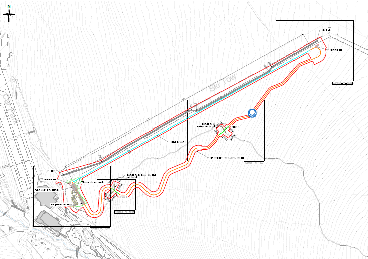
Moreover, even the more detailed plans fail to show the poma lift infrastructure:
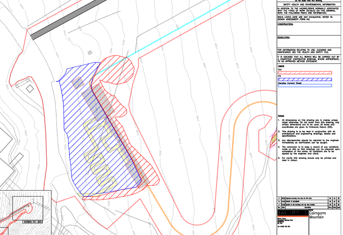
The grey line at the top is the access track which is supposed to run along the Poma, so why is the Poma infrastructure not clearly shown so one can understand the relationship between the two? The best that I can find showing the relationships is from the corner of another plan which shows the design of one of the bridges:
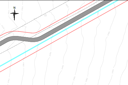
The dotted lines on this plan appear to be related to the Poma but what they are intended to show is not clear. It is possible they show the snow fences on either side of the Poma uplift but it is not right that anyone who wishes to comment on the application is left to speculate.
The absence of information about the Day Lodge Poma raises questions about its future and can only feed speculation that CMSL/HIE are planning to remove it. Doing so would be a disaster for snowsports and increase even further the reliance on the funicular for access to the lifts on Sròn an Aonaich and Coire na Ciste.
Landscape impact of the coaster and track
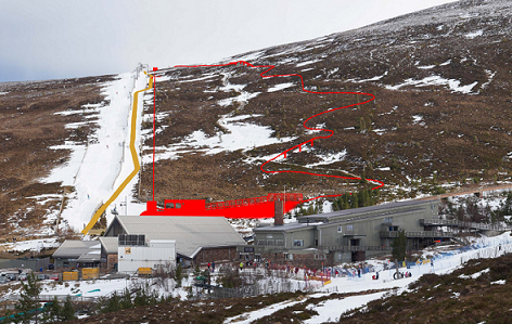
This photomontage from the far side of the Day Lodge clearly shows the relative sizes of the various elements of the development and is helpful for considering their potential visual impact on the Cairngorm Mountains National Scenic Area. The red and tan lines should not be taken as showing their actual visual impact.
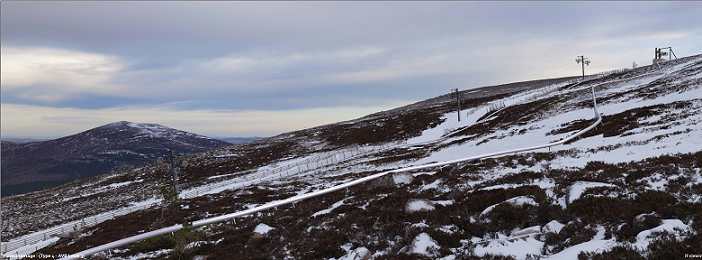
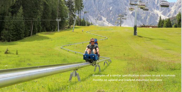
Most of the proposed coaster track is close to the ground, as this photomontage illustrates, and will have less impact than the proposed dry ski slope which the Cairngorms National Park Authority (CNPA) rejected on landscape grounds. Unfortunately this is the only visualisation from close-up and there is nothing to show what the two proposed bridges over the existing footpath will look like to walkers.
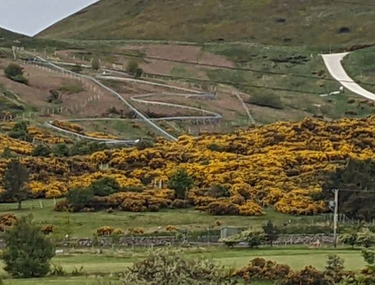
The visual impact of the rail itself will vary according to light conditions and also be affected by the reflective properties of the metal used to fabricate it. When traveling out of Edinburgh on Friday on the A702 the coaster at Hillend stood out in the morning light from about 2km away. On the way back I stopped and took the top photo from closer by but in poorer light. The Hillend coaster raises serious doubts about the claim in the Planning and Design Statement that the landscape ‘impacts will be minimal’.
The Hillend coaster also raises questions about why CNPA staff agreed to limit the visualisation points to an area within 1.5km of the proposed development? The landscape issue at stake here is whether in sunny conditions the coaster rail could be seen glinting from as far away as the other side of Strathspey.

The LVA states that ‘the extent of the buildings and infrastructure is limited and keeps the main building and storage facilities close to other existing grouping of buildings’ which in my view is a fair assessment. The LVA was, however, conducted in January, when there was a lot of snow, and there are no images to show what an eroding access track would look like in summer.
The LVA repeats the following comment for no less than five of the viewpoints chosen to assess the impact of the development:
‘There is also the possibility that the current policy of woodland creation could be continued within the locale. For an indication of where tree planting was undertaken in 2022 and 2024, and the extent of future proposed tree planting, see Figure 05: Wider Woodland Strategy. If the Wider Woodland Strategy were implemented, the existing and proposed views outlined above would come to feature emerging woodland cover extending east up the lower north-western slopes of Sròn an Aonaich and northeast from the Cairngorm Mountain ski resort.’
The LVA is correct to state that woodland, whether planted or naturally regenerating as at present, could in time screen most of the proposed coaster infrastructure and preventing reflections from the metal structure being visible from afar (there is a question about trees here would ever grow high enough to conceal the bridges). The LVA, however, refers to woodland planting as a possibility rather than a concrete plan and whether anything happens would appear to depend on funding from HIE.
That lack of certainty about funding raises the question why CMSL did not ask the Spey Catchment Initiative to plant trees above the Day Lodge, rather than giving the go ahead to the montane woodland project last year (see here)? The slope above the Day Lodge would have been a far less controversial site.
The planning implications for the Cairngorms National Park
Setting aside the most fundamental question, which is whether it is appropriate to construct a coaster and other similar visitor amusements high up on Cairn Gorm, the CNPA needs to address a number of issues relating to the impact of the proposed coaster. starting with clarifications about exactly what is proposed and how that would relate to the existing ski infrastructure.
Whatever else the CNPA decides there is no justification for the proposed permanent access track. This will be of little use for maintenance and emergency purposes and is far too steep. It is also contrary to the CNPA’s policy presumption against new tracks on moorland (policy 4a in their National Park Partnership Plan). Reference to that is omitted from CMSL’s Planning and Design Statement.
It appears from their agreement with the developers about the landscape visualisation points that CNPA staff are unlikely to recommend the coaster itself be refused on landscape grounds. If that is the case they should nevertheless put in place measures to minimise the landscape impact. These should include a requirement that the metal structure has a matt finish, to reduce the amount of light it reflects on sunny days, and a legally enforceable plan for tree planting.
The CNPA should also be mindful of what happened at the Shieling in 2016 with the rope tow development (see here). To prevent such inappropriate and destructive work happening again the CNPA should insist on a far more detailed CEMP and require independent monitoring of any works on a weekly basis.
While the landscape impacts of the coaster could potentially be mitigated to an acceptable level if the access track was removed, that does not mean the proposed development is justified. My next post will consider the proposal from a cost/benefit and wider public interest perspective.

This post confirms my overall thoughts on the planning application documents. There is a lack of clarity in the ‘mesh’ of documents submitted by the applicant. For me, it demonstrates that there has not been the coordination between the various consultants and contractors in writing the documents. Although CMSL should have checked this out before submission, I believe the main fault lies with the agent who submitted the application on CMSL’s behalf. If I were CMSL, I would be insisting that the agent further reviews the documents and corrects and clarifies them before further consideration of the application by CNPA. Furthermore the consultation period should be extended to enable public consideration of the revised documents.
Yet another shambolic project under HIE’s ownership of the upper mountain slopes of Cairn Gorm. When are our MSPs going to get a grip of this government agency whose main expertise seems to be the wasting of massive amounts of public money on this mountain, under a cloak of secrecy and mis-information? We need, as a matter of urgency, a independent public inquiry into HIE’s performance on this mountain over the last 30 years and what to do about them in the future. That inquiry should be led by a judge, with all witnesses appearing under oath. Only then will our politicians and the wider public understand what a menace HIE are and how they need to be dealt with.
Well said. It’s a farce and it might even be a criminal farce. I find your comment ‘shambolic project’ a bit bland and anodyne!
I have just opened today’s Saturday Press and Journal and guess what occupies two pages – Landmark Forest Adventure Park at ~Carrbridge is just building a £500,000 adventure toboggan run for the 170,000 visitors they get a year.! They visited a successful one in York and designed theirs the manager says “to make it bigger, faster and more fun!” It is important he says that it is attractive enough to ensure users come back again to enjoy it – 70% of their visitors are repeat visitors.
There is a limited market for any kind of attraction. Now if you are taking your kids out for fun on Speyside to enjoy something like that where would you rather take them? Nip down to Carrbridge where they can also enjoy other attractions, or drive miles up the hill to Coire Cas – especially if the weather is not too great?