[Update. Apology for the reference to Standard Life in the headline. SL merged with Aberdeen Asset Management and are know known as ABDN although their Investment and Property Income Trust kept the old name till last year].
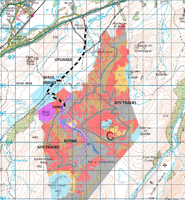
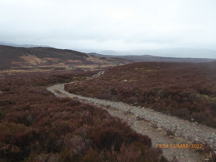
I have been watching the Standard Life Investments and Property Income Trust (SLIPIT)’s plans for the part of the Ralia Estate, now called “Far Ralia”, since they bought it for carbon offsetting purposes in September 2021 (see here) and have walked round the estate linking the main hill tops (light blue on map). I was pleased to be consulted on the original plans for woodland by SAC consulting but when plans to upgrade 5590m of road network on the “old” Ralia and Far Ralia Estates were lodged with Highland Council at the end of last year I asked the Cairngorms National Park Authority (CNPA) to call them in, which they did.
The (CNPA) then notified me on 1st February (in the email which I first mistakenly thought referred to the Glen Banchor track see here) that the plans had been withdrawn from their planning register. What they failed to say was that a new Prior Notification had already been lodged on the Highland Council Planning Portal on 19th January (see here). More planning yoyos (see here)!
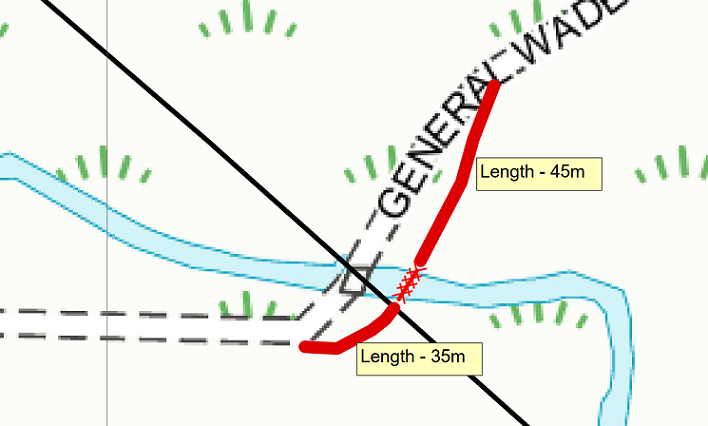
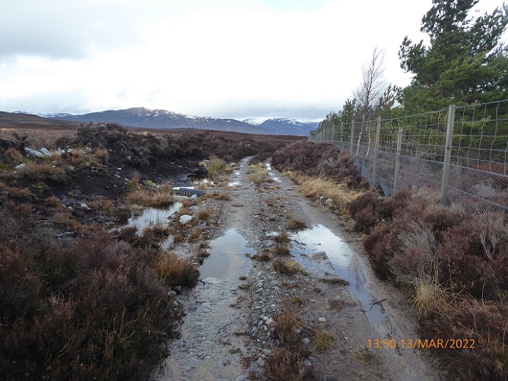
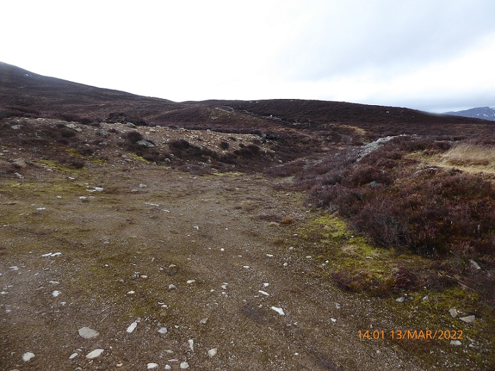
SLIPIT changed its name to the ABDN Property Income Trust last year and the new Prior Notification sets out ABDN’s intention to upgrade 4050m of track from Milton of Nuidhe by the A9 to the ford on the Allt Ghuibhais, increasing the width from 2.4m (suitable for a landrover) to 3.5m, and to undertake repair work on a further 2570m of track above in order to plant trees. In addition the plans show a new network of new ATV tracks, up to 3.5m wide, which don’t require planning approval as they do not involve removal of vegetation. The total length of these ATV tracks appears to be around 25km.
The purpose of the road upgrades?
In their Supporting Information to the planning authority SAC consulting claim that the road upgrade, repairs and ATVs tracks are part of a plan to create 950 hectares of native woodland and that since the tracks are for forestry purposes they do not require full planning permission.
While SAC state “Approval is currently being sought from Scottish Forestry under the Forestry (Environmental Impact Assessment) (Scotland) Regulations 2017”, as yet there is no plan listed on Scottish Forestry’s register. As a consequence there is no confirmation that the proposed track upgrade is actually required for forestry purposes. Both Highland Council and the CNPA therefore have every reason to require the proposed work to have full planning permission, not least because it includes the construction of a completely new bridge alongside the Wade Bridge.
SAC consulting do not explain in their plans why the current track, which includes sections of the Wade Military Road, is not sufficient for the purposes of planting trees but justify the upgrade proposal as follows:
“This upgrade will be to create access to the site [i.e. Far Ralia] that has multiple benefits. The main benefit will be to give upgraded access capable of running heavier vehicles than a 4×4. This is to give access during the operational phase of the project and to allow access to firefighting equipment, should wildfire ever be an issue. The improved running surface will also be beneficial from a health and safety perspective, in relation to employees and contractors being on site.”
SAC’s justification of the upgrade is mince. There is no need for vehicles that are heavier than 4 x 4s to plant trees and the proof of that lies in the supporting statement and the map above. ATVs, not heavy vehicles, will be used to transport trees across the site. The firefighting equipment argument is also nonsense as the 3.5m wide upgrade ends shortly after entering the proposed woodland planting area, meaning that the vast majority of the site would remain inaccessible to fire engines. As for the health and safety and comfort of the people planting trees, modern vehicles have such good suspension that tracks like this pose few issues. SAC consulting should be far more worried about workers on ATVs disappearing into the areas of deep peat crossed by the proposed ATV tracks!
So why then is this track upgrade being proposed?
One possibility is that ABDN are also planning to restore areas of peatbog high up, work that normally involves heavy machinery. But if that was the case, why have they not also applied to upgrade rather than repair the higher section of track? Moreover, the map indicates that ABDN are planning to plant this area of bog with trees which, while seriously damaging it releasing large amounts of carbon into the atmosphere, won’t require use of heavy vehicles.
Another possible explanation is that when Standard Life/ABDN bought Far Ralia they committed to upgrading the access track to it across the seller’s land. That would help explain why most of the upgrade work is not on ABDN’s land. But if that is the case, it clearly isn’t required for forestry purposes and there is even more reason to call in this application.
Wade’s Bridge
[This section was updated and corrected 3rd March]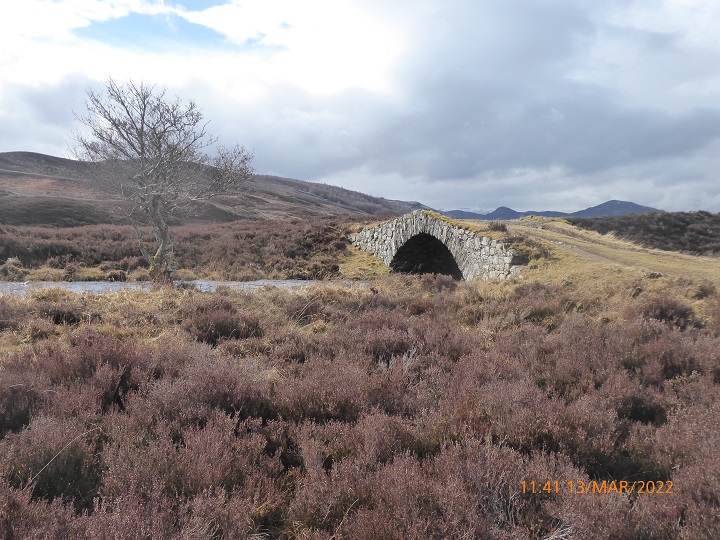
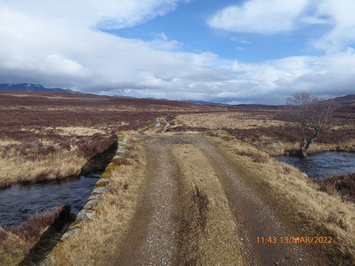
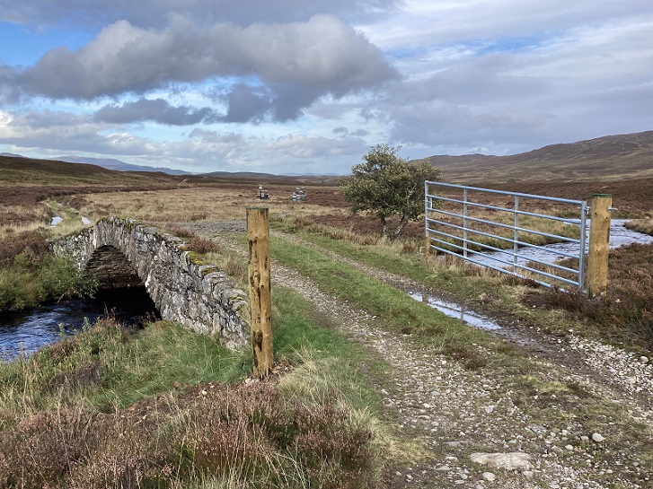
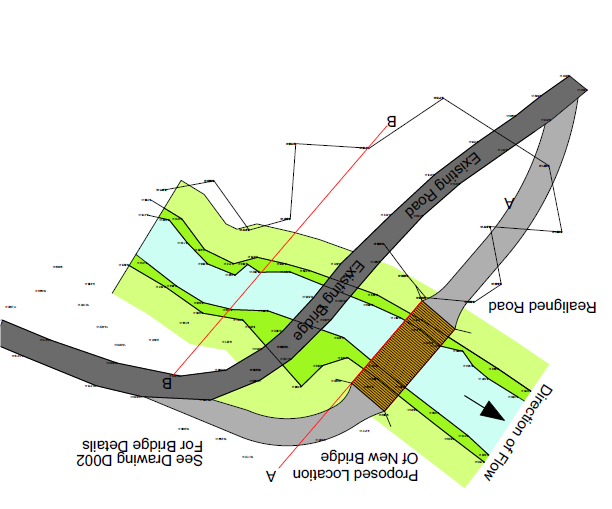
While Wade’s bridge, a historic monument, has proved quite adequate for landrovers it could not be used for heavy vehicles and the prior notification includes plans to build a new bridge next door to the existing one. This is crass and takes no account of the historic landscape setting – the CNPA, incidentally, has a statutory duty to conserve the cultural heritage and is at present as far as I am aware still trying to resolve issues created by an erection of an intrusive new gate across the end of the bridge.
Moreover the plans are far from clear, being orientated in opposite directions
The general plan is dated 26th August and may have pre-dated the gate that has been erected across Wade’s bridge but the developer should have ensured it was included in the plans they have subsequently submitted and explained its purpose.
Since trees can be planted using ATVs and landrovers, there is absolutely no justification for replacing the Wade Bridge to make it useable by heavy vehicles and this part of the proposal therefore clearly requires a full planning application.
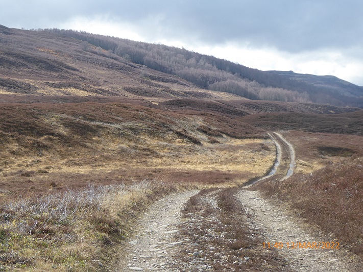
The upgrade and repair work
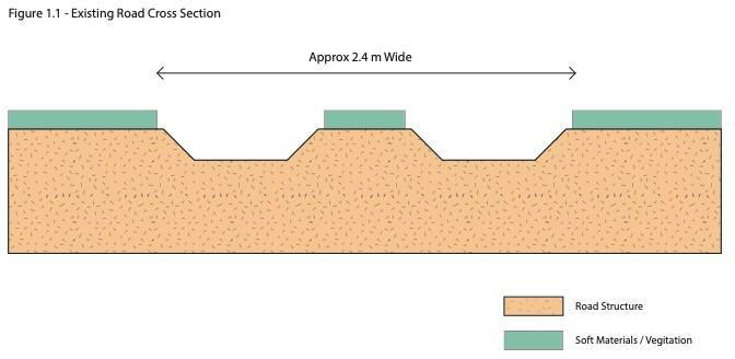
The upgrade proposes to replace a 2.4m wide track which has a vegetated strip running down the middle which in cross section looks like this:
with a raised track which in cross-section looks like this:
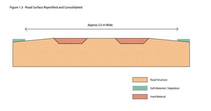
There are some good arguments that raised tracks, which shed water, are preferable to other designs in some places. However, no evidence has been provided that water is causing serious problems on the existing track, possibly because it and the ground beneath it drains well.
Moreover, even if such a track could be justified here, it is too wide, there are no proposals to cover the central strip with vegetation and the plans for the verges are vague. The supporting statement claims “Useable hard materials from the centre and sides of the road will be used to fill in established running tracks and allow water run off” but this is likely to affect a considerably wider area than shown in the diagrams as there is not enough material within the footprint of the existing track to create a new higher, broader one. How this will be restored is unclear.
Consequently, the upgrade proposals are likely to have significant adverse impacts on the moorland landscape.
The Supporting Information states that the repairs to the 2570m of track above “will be to fill in potholes and maintain culverts” but contains no details of the extent of the work or how it will be done, except the the culverts will be of plastic – bad for carbon and bad for the environment.
Wider issues – tracks and peat
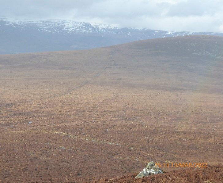
After following the course of the Allt Ghuibhas, the upper track enters an area of peatland by another native woodland plantation and then turns south west across an area of bog (clearly shown on the map above) towards Gharbh Meall Mor. The construction of this track has not only affected the drainage of the bog, it has left extensive areas of exposed peat which have been leaking carbon into the atmosphere ever since.
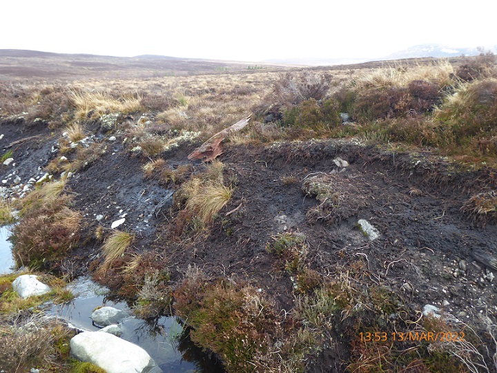
The Prior Notification also says nothing about how they plan to restore the area of damaged ground at the top of the existing track, the starting point for one of the new ATV tracks.
I will come back to ABDN’s final planting proposals for Far Ralia when they are public – it will be interesting to see if they still include proposals for damaging new fencing – but the fact that they are unconcerned about the impacts of the existing track and proposed ATV tracks on peat bogs suggests they understand little about either carbon offsetting or the natural environment.
This Prior Notification also illustrates the continued split between forestry and peat bog restoration, the failure of these interests to see the bigger picture and the apparent inability of the new “green” lairds like ABDN or BrewDog to bang the heads of their various consultants together.
The CNPA and what needs to happen
In situations like this, the role of the CNPA should be to ensure more joined up thinking on the part of landowners and between various development interests, e.g foresters and the people working on peatbog restoration, in order to reduce carbon emissions and promote the restoration of the natural environment.
Unfortunately, having called in the first prior notification and notified Highland Council of their intention to do so with the second, the CNPA then changed their mind (see here). While the emails are redacted and far from clear in meaning, the CNPA have been good enough to clarify that at present they do not intend to call in the application. I think that is wrong, have told them so and hope they change their mind.
In planning terms until a forest plan has been agreed, the track upgrade should not be considered under the Prior Notification system. Meanwhile it is clear the work is likely to have a significant impact on the natural and cultural landscape. If you are concerned you can comment on the Prior Notification here .
Taking a wider view, however, the CNPA should be using this application to work with Scottish Forestry to require ABDN to produce a plan for their land which ensures that:
- deer numbers are controlled without fencing;
- natural regeneration of woodland comes before planting;
- no planting takes place on peat; and,
- areas of damaged bog are restored without using large mechanical diggers which would require new tracks.

The name of the owning trust is now abrdn Property Income Trust, and abrdn are responsible for the management of the trust, so they are who comments and complaints should be addressed to. (I appreciate the planning documents appear to have been completed with the old ownership name, probably the fault of the agent)
The Standard Life brand name has been sold to Phoenix Group, an insurer, and is no longer connected to this trust.
Thanks very much for pointing this out. I did know Aberdeen and Standard Life had merged but SLIPIT had kept its name and I missed the fact that this was changed too (last August I think). Stupidly, instead of saying SLIPIT, I shortened this to Standard Life as the agents had done in the planning application. I have update the post but cannot change the headline unfortunately without breaking all links
I think the two maps of the proposed new bridge are the same, just oriented differently. The new bridge will be downstream of the Wade one.
Thanks, you are right, map showing the design of bridge had no direction on it and was presented upside down compared to the location maps. It is still not accurate however as it does not show the gate the gate that was erected across the Wade Bridge (that may be because the map was drawn on 26th August 2022 and the gate may have been put up after that date but if so SAC consulting should have had the map updated before submitting the prior notification)