On 4th November the Cairngorms National Park Authority (CNPA) notified all those who had commented that the proposal to create a 4.83 km road linking the Pitmain and Glenbanchor Estates, allegedly for forestry purposes, had been withdrawn (on 27th October). In a post the following day (see here) I highlighted the lack of any explanation of why the application had been withdrawn, expressed concern could come back and highlighted how the removal of most of the planning documentation, including the objections, was not in the public interest. Little did I know that on 1st November the Pitmain Estate had submitted a revised application (see here) for a very similar road to Highland Council!
Clearly there was something going on that has not been explained. The lack of transparency on the part of the CNPA does it no credit. Its decision to call in the application on 12th December, while right, also means that the three weeks the CNPA allow for the public to comment falls over the Xmas period. I hope the CNPA will do the right thing, extend the period the public have to comment and contact all those who objected to the previous application drawing attention to the new one.
The differences between the current and the previous application
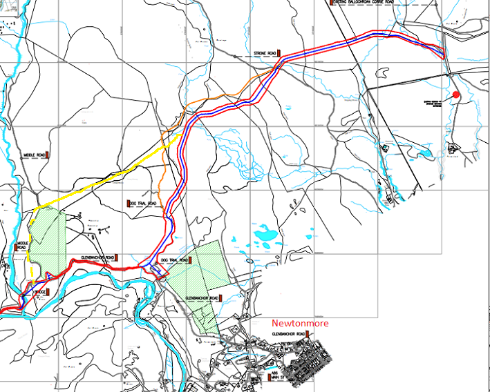
The main difference between the new application (see here for planning papers) and the previous one is the line taken by the proposed road, described in the application form as a “revised location”. The proposed road now follows a lower route round the hill, presumably following advice from CNPA planning officers that if the estate really wanted to press ahead with a planning application this could reduce its visual impact.
The other main difference that I have been able to establish – there is no clear statement of the differences in the planning documents – is the number of borrow pits. These have been reduced from several to one by dint of using bulldozed material from excavated sections to fill in dips in the ground.
Besides these two differences, there are many more documents than there were in the previous application. All of which date from when that application was still being discussed with the CNPA and may well have been provided as a result of their advice. These include a “Swept path analysis” – jargon for a road survey – visualisations of the proposed route, a peat survey and the Supporting Statement. Essentially, however, it is the same application and has been justified for the same reasons, that the road is necessary for forestry purposes.
What is the purpose of the road – forestry or sporting purposes?
The Pitmain Estate has still not explained why a new road is needed to extract timber from Glen Banchor. The North East Mountain Trust has summarised the position very well in their objection:
“NEMT’s overriding concern is the question of the need for the track and its purpose along with the negative landscape impact. The stated purpose of this track is to remove timber from four relatively small plantations affect by wind blow. The application is based on the likelihood that normal timber lorries will be unable to negotiate the public road down the glen. The application does not say why small vehicles could not be used to remove the relative low volumes of timber involved, perhaps with some temporary alterations to Glenbanchor Road, as suggested for the upper section of the road. NEMT understands that Wildland Ltd is using small vehicles on narrow tracks to remove cut timber elsewhere in the Cairngorms National Park. NEMT raised this in respect of the previous application and it is not addressed in the current application”.
It is worth, however, adding to this some additional points.
Glen Banchor and Pitmain were separate estates until 2017 and when the trees were originally planted the expectation would have been that they would have been extracted down Glen Rd. If extracting them had depended on creating a new road over to Ballachroan, which is what is being proposed now, the then owners of Pitmain could have held the then Glen Banchor owners to ransom (i.e charged enormous fees both for constructing the road and then allowing Glen Banchor to use it). The main reason that Glen Road is no longer judged suitable is simply because standard timber lorries have grown enormously in size. The answer, as NEMT argue, is to use smaller lorries.
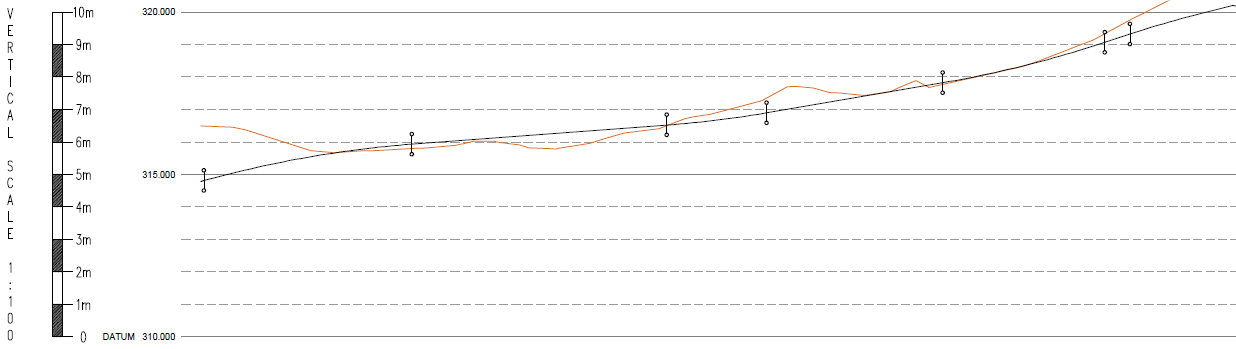
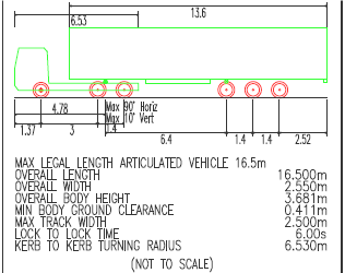
The inclusion of a number of “Swept Analyses” of Glen Rd in the new application, annotated with comments like “”Reduced Forward Visibility” and “overhead power lines crossing” are meaningless without an analysis of how this would effect timber extraction. For example, the Electricity Supply Regulations (see here) set a minimum height for overhead powerlines crossing roads of well over 5m which is significantly greater than the height of the lorries included in the analyses:
If full-size bin lorries can use the road safely at present – I have seen them – why couldn’t smaller timber lorries do the same? The supporting documents avoid this question because it undermines the ostensible rationale behind the application.
Then there is the timber which is supposed to need extracting. Much of this is windblown and therefore commercially valueless. The CNPA should ask Pitmain to get a report from a qualified forester to inform them how much timber is salvageable and what it is worth compared to the construction costs of the new road. Unless the value of the timber is significantly greater than the construction costs, it is safe to conclude that the real purpose of this road is not for timber extraction.
The Proposed Woodland Management Plan included in the application raises further concerns:
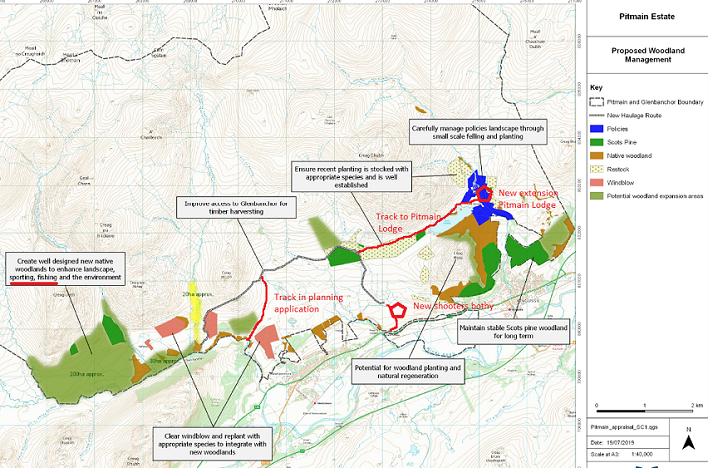
The map shows:
- that the estate describes several of the Glen Banchor plantations as windblown and proposes to clear them before replanting (the pink blobs on the map above);
- a different line for the new road (in black) than what is shown in the planning application
- that a primary purpose of the new native woodland in Glen Banchor is to enhance “sporting” and “fishing” which means that after any initial extraction, the new road would be unlikely to ever be used again for forestry purposes.
The new road would, however, provide quicker access to Glen Banchor from people staying in Pitmain Lodge (construction of a new wing there is currently being considered by Highland Council) and from the luxurious new bothy on the Ballachroan Rd where shooters go to have their lunches (I have marked both on the map).
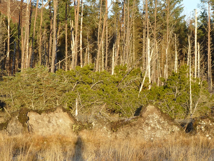
Why the windblown plantations need clearing is not explained. Why not leave them to rot and regenerate naturally as has happened at the windblown plantation near the end of the public road?
And if there is too much fallen timber for seedlings to grow through, why not invite people from Newtonmore to come and help themselves to some of the wood? That might be particularly welcome given the fuel crisis.
The landscape impact of the proposed road
It may be challenging to evaluate the impact of a new road in this landscape because of the nature of the terrain, bog on the flatter area below and a complex field of glacial moraines above. However, the application only contains five viewpoints to cover the impact of almost 5km of road and the visualisations that have been provided are complete crap:
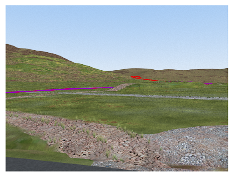
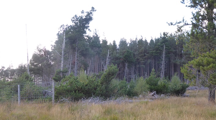
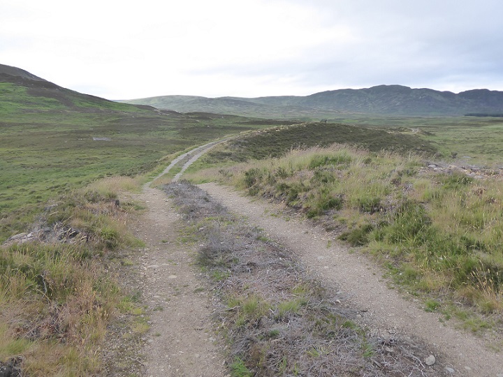
From the visualisation you would have no idea the new road is proposed to run beside the fine esker on the top of which runs the dog track. This was upgraded in 2017 after Pitmain bought the Glen Banchor estate, creating a terrible mess (see here). It was then granted retrospective planning after remedial works were negotiated with the estate, a mistake as I argued at the time. The photo below gives a far better idea of how the area actually looks and the likely visual impact of a new road running alongside it:
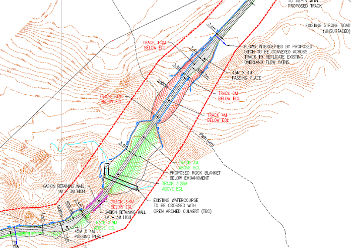
The maps in the application are a better source for evaluating the landscape impact of the new road network. Below is the map showing where the new road would connect with the public road in Glen Banchor, together with a connecting branch to the windthrown plantation to the south:
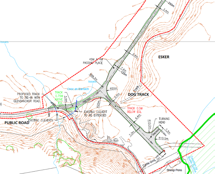
Note the 45 x 4m passing place, one circa every 200m along the road, and the “turning head”. None of this is evident from the visualisations. The two roads in parallel, one on top and one below the esker, shows just how little regard the Pitmain Estate and the consultants who work for them have for the Scottish landscape.
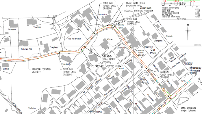
The suburbanisation of the landscape and another indication of the real purpose of the road is also evident at the other end where it meets the Ballachroan Road:
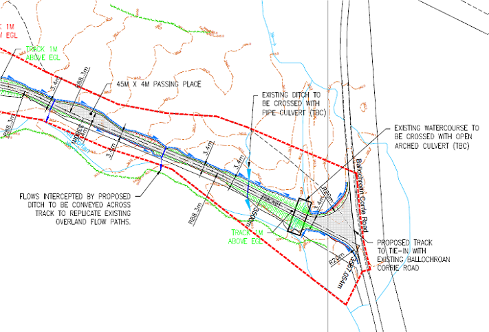
Why the need for a junction opening 20m wide? And why does this also face both ways if the purpose is for timber lorries coming from below (the bottom of the photo)? It appears the owners of the Pitmain Estate, their staff and guests want to be able to get to places fast (hence too all the passing places).
From a landscape perspective, the application fails to assess the impact of the cuttings and embankments which are shown in the plans:
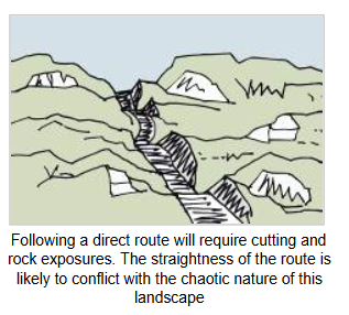
The Design Statement claims that the road construction is in accordance with SNH guidance on “Constructed tracks in the uplands” (see here). A cursory glance at that guidance, which starts by suggesting alternatives- like the public road in Glen Banchor! – should be examined before deciding to build new roads, shows that this is not the case. There is even a diagram (page 35) advising that roads should not be constructed in straight lines up slopes as is proposed above!
The CNPA adopted a policy presumption against new hill roads mainly because it wanted to protect the landscape in the Cairngorms against damaging impacts like this. How it has allowed these proposals to get this far is unclear and a moot point. But this road proposal should be regarded as a test case of their commitment to protect the landscape.
Carbon impact
The Design Statement claims that the road has been routed “to avoid any deep peat disruption”. This may be true, most of the route is through moraines which are generally well drained and therefore peat free. However, the statement that “NB: 77.92% of track route has a peat depth of less than 0.5m and 93.07% of track route has a peat depth of less than 1.0m” is misleading. The Peat Survey Report is far more instructive: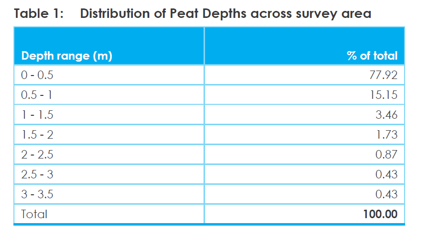
By my calculation a minimum 254 cubic metres of peat could potentially be destroyed by the 0.43% of the 4.83km road which will be constructed on peat over 3m deep.
The emphasis the Design Statement has put on the amount of peat affected that is less than 0.5m deep appears to be because the UK Forest Standard now prevents cultivation of peat of greater depth and if accepted as a forestry road those standards would presumably apply. The problem, however, is those standards are now completely out of date and unfit for purpose, particularly in Scotland where most of the UK’s peatland is found.
While also not clearly stated in the Design Statement, it appears from the diagrams that the Pitmain Estate is proposing to use some of the “surplus” peat from the road construction to create a vegetated strip down the middle of the road:
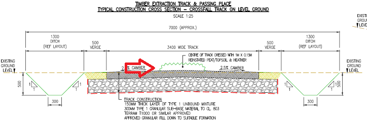
While vegetated strips down hill roads are generally welcome, re-using peat to create them will destroy that peat and will be like using peat as garden compost. Peat is created and develops in water-logged conditions but the centre of the track is well drained so any water that is in the peat will drain out the sides. This peat will therefore quickly degrade releasing carbon into the atmosphere.
Unfortunately the owners of the Pitmain estate, the Jafar family, are unlikely to be greatly concerned with how much stored carbon the construction of the road might release into the atmosphere. Majid Jafar, who appears to be head of the family, is Chief Executive of the largest private oil company in the world, Crescent Petroleum. He is therefore one of those with primary responsibility for continuing to pump carbon into the atmosphere despite the warnings of scientists and the catastrophic climate change induced events that are afflicting the world.
The CNPA could, however, force Mr Jafar and others like him take a little notice by taking a stand against new developments like this in the National Park, not just because they are not needed or because of their impact on the landscape but because they are not carbon neutral.
Commenting on the application
I know its Xmas, but for anyone concerned about the abuse of power by landed interests, the landscape or climate change this planning application matters. Please consider commenting, you can do so here.

The moment any planning application appears – to an informed member of the public- to be so thoroughly compromised, the pubic interest appears to held in contempt, the matter should be ‘called in’. Unfortunately for tax payers is time for formation of a top rate ‘national inspectorate’ of Planning matters. This central office should be staffed almost anonymously rather like a coroner service…kept very remote from local authorities. The threat of some big dream development being “arrested” pending inquiry , with all the potential for delays that would then result – might just concentrate the minds of applicants and accountable officers of councils, to do the job correctly, and without fear or favour. With draconain powers to disbar planning officials, or indeed the developer’s own legal advisors, the most blatant examples of land owners “playing the system” for personal gain should then never occur?