Notifications that two of the Glen Etive hydro applications had been withdrawn were issued by Highland Council last week but, before anyone celebrates, they have been replaced with new applications for the Allt Mheuran and the Allt Fhaolain. That re-starts the whole planning process. If you objected first time round, that objection is no longer valid. If you did not manage to comment then, now is your opportunity!
Highland Council has allowed Dickins Hydro Resources to resubmit most of the original planning documents with the new applications. The main changes for each application are explained in a Supplement to the Environmental Impact Assessment (EIA) for each scheme.
The two schemes are the ones that attracted the most objections, the Allt Mheuran, because of its landscape and wild land impact and the Allt Fhaolain because it would have made the Grampian Club Hut at Inbhirfhaolain unusable. There are however also some general changes which affect all seven schemes. This post will take a look at the issues in turn.
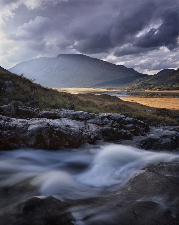
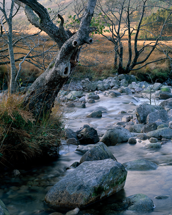
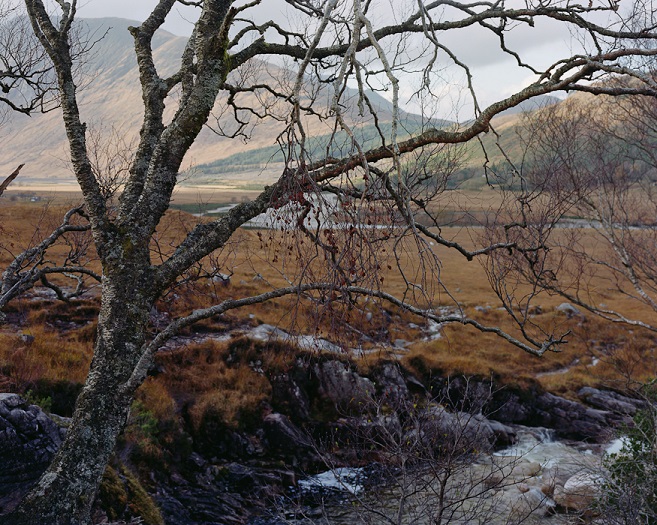
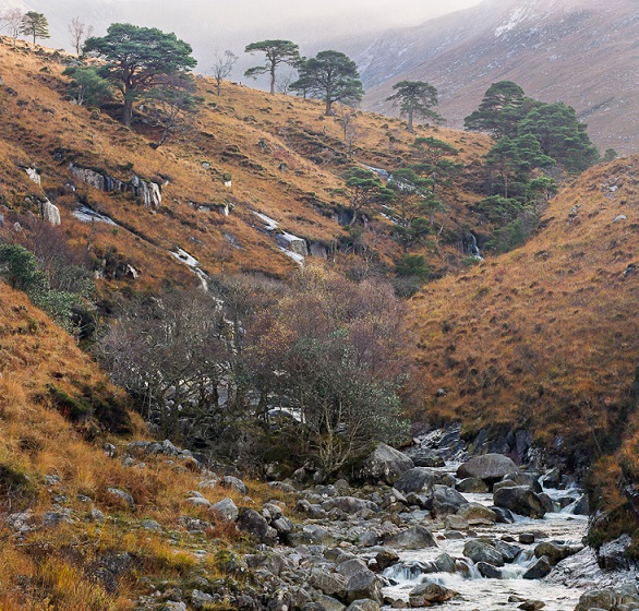
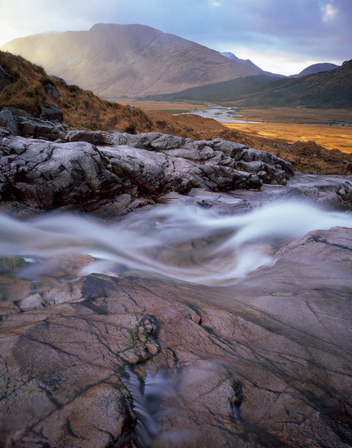
I had intended to blog on Glen Etive again (see here), (here) and (here) before the end of the summer. I can only apologise to the photographers who provided images then for not using them until now. I am grateful to Tim Parkin, who runs a landscape photography magazine, for collecting them. They help show, more than words, what is at stake.
General issues
The supplement to the EIA contains changes which apply to all seven schemes. Legally, everyone who originally commented on any of those schemes should now have an opportunity to comment on the proposed changes. So far, Highland Council has not notified people about this.
Undergrounding of powerlines
One of the changes which affects all 7 schemes are powerlines. A major omission in the original plans was a failure to explain how the new powerlines would be undergrounded. That proposal has now been dropped. Instead the developer reports that SSE is proposing to upgrade the existing powerline along the glen. This, in my view, is a major step back. The double standards of SSE who yesterday received extensive positive media coverage (see here) for REMOVING overhead powerlines in the Cairngorms National Park is striking . Why is SSE even contemplating upgraded power lines in an area which are just as beautiful as the Cairngorms, many would say more so, albeit lacking National Park status? .
From a planning perspective, if Highland Council as Planning Authority believes pipelines can be buried without lasting damage, the same must apply to powerlines. A pre-condition for any hydro scheme being considered in a National Scenic Area should be that the powerline is buried and Highland Council need to force SSE to re-think in Glen Etive.
Restoration of access tracks?
The second major change affecting all schemes are the revised proposals for restoration of construction tracks. These are hidden away in a new construction standards document (see here) and are hard to follow.
2.1.2 Access track to intakes
Issue: Misunderstanding brought about by a typing mistake in the original EIA document that wasn’t picked up. Stated that there would be “a permanent access track to the intakes”. [Comment: how was this a typing mistake?]
Solution: This is contrary to the CMS documentation and constraints plans where they state that the “temporary access track which will be 3.4m wide will be reinstated to ATV tracks 1.5m wide” post construction. This applies to all temporary access tracks created to facilitate construction access to the intakes.
While in principle this is welcome, what is actually being proposed is still every unclear – a construction track is not “temporary” if it is to be retained permanently.
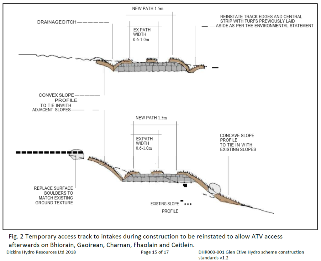
The diagram illustrates that Dickins Hydro is not actually proposing to restore the tracks – which would mean removing the imported material – but rather to cover them up. That will have a lasting impact on landscape and ecology. What is not explained.
“It may be impractical to remove these tracks altogether. Therefore, regrading of the uphill ‘cut’, the creation of a drainage ditch, the use of a cambered surface and regraded downhill ‘fills’, together with the careful recycling of turfs to vegetate the previously bare cut and fill areas.”
Standard advice on track design recommends that if they are to avoid significant landscape impact they need to avoid cutting across slopes as illustrated.
11.4 Track removal / reinstatement
If the removal of a track is necessary, careful consideration should be given to the relative impacts of restoration, enhancement and maintenance. The desirable solution may not always be the most sustainable.
So what exactly is being proposed for the five schemes listed under the diagram? We don’t know. Statements such as this do not inspire confidence:
Where banks have been disturbed and the natural vegetation has been removed coir matting is to be pinned in place over the banks to assist in holding soil in place while regeneration takes place.
So not all vegetation is going to be retained and restored?
The omission that underlies this is that there are no detailed proposals for how the vague design principles and statements, good or bad. will, for each scheme, be applied on the ground. That appears to be being left to the contractor. Its not clear as a result what the impacts will be. That omission needs to be rectified and if the Developer cannot show these new ATV tracks will have no more impact on the landscape than a well constructed path the whole scheme should be refused.
Among the other issues which Highland Council should tackle are:
- How to restrict ATV use to any new permanent track. Otherwise all that will happen is ATVs will use the new tracks and then head off up the hill creating more damage
- That the best line for a path/ATV track will not necessarily follow the construction track. Good paths don’t take straight lines up hills but wind through the landscape. Planning Authorities should resist proposals which claim that narrowing tracks to 1.5m will in itself remove the landscape impacts. Instead, they should ask for a detailed layout for all permanent new paths and an assessment, from a reputable expert, which shows they take the best line. The best walking track for example might be close to the burn where a construction track would not go.
- A plan for ongoing maintenance otherwise the paths will deteriorate. To give Dickins Hydro credit they do refer to the need for maintenance but its unclear what they are proposing. Planning Authorities should insist that a proportion of future income from hydro schemes is set aside in a maintenance/restoration fund.
Enforcement of planning conditions
If detailed plans for new ATV tracks can be got right, there is then the issue of how Highland Council will ensure these are delivered. The Developer claims that the appointment of a Landscape and Ecological Clerk of works who will meet with the contractors once a month will ensure this. That is highly unlikely. The people appointed to fulfil these functions depend on the developer to be paid. They are thus not independent. In a month the whole landscape could be destroyed with modern machinery. This could all be fixed if the Clerks of Works were appointed by the Council, were paid for out of an independent fund financed by the Developer, reported to the Council on a weekly basis and had the power to stop any works which were not being carried out according to the detailed specification.
The Allt Mheuran scheme
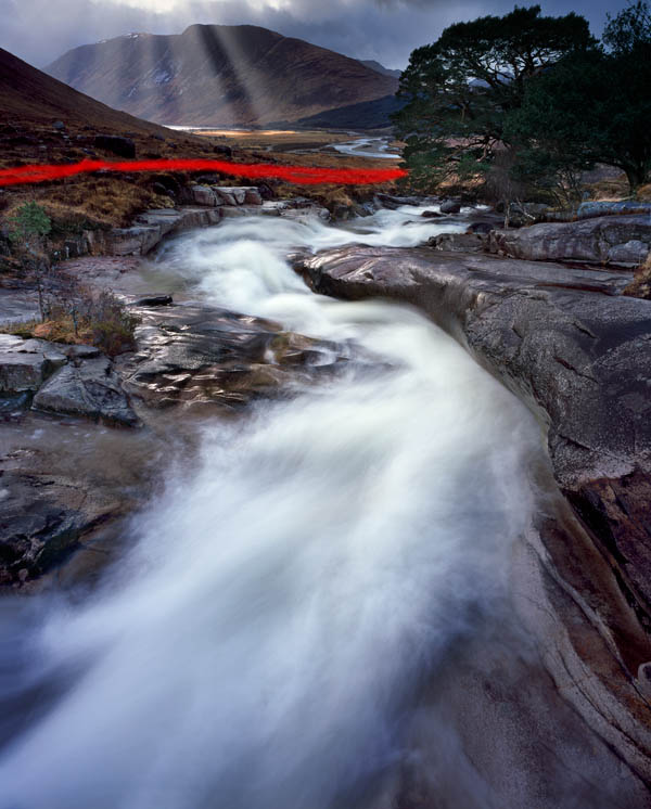
The original proposal has been significantly amended (see here for docs and to comment). Instead of two intakes there are now one and this has been relocated c550m downstream to well below the famous Robbers Falls. It is now claimed that the construction track will be completely restored, i.e.covered up, after the pipeline has been laid and the intake built and access to the intake should be on foot.
This sounds welcome in principle and will reduce the landscape impact significantly (photo above). It rather begs the question though if its feasible to lower the intakes and remove the tracks at the Allt Mheuran, why not apply the same thinking to the other Etive schemes too?
Unfortunately the claims don’t match reality. The revised proposals (see here) are still far from clear, show that new tracks are still being proposed and raise a number of other serious landscape issues:
- “regular maintenance inspections of the intake will be done on foot with cleaning equipment kept on site, to minimise long term impact. On occasion should materials and equipment be required on site, these could be ferried there by quadbike, thus minimising the impact.” So will access be on foot, by the existing path, or quad bike? Regular quad bike use will have a deleterious landscape impact. It therefore needs to be controlled.
- 2.2.4 New access around Coileitir
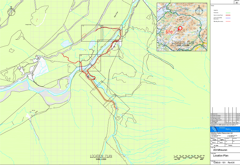
A new permanent access track to the Mheuran powerhouse, around the south side of Coileitir, is proposed. SEPA request a habitat survey for the new access track, however DHR Ltd submitted this report and habitat map with the original planning application. So not all new construction tracks are going to be restored after all? What is the specification for this new track? The Developer says this will be upgradedand realigned but gives no apparent consideration to the landscape impact.
- There is second section of new, and presumably permanent, access track which heads more directly across the River Etive (see plan above). Again, I cannot find any assessment of the landscape impact.
- The Zone of Theoretical Visibility Assessment has not been revised – it dates from December 2017 – despite the significant changes to the scheme
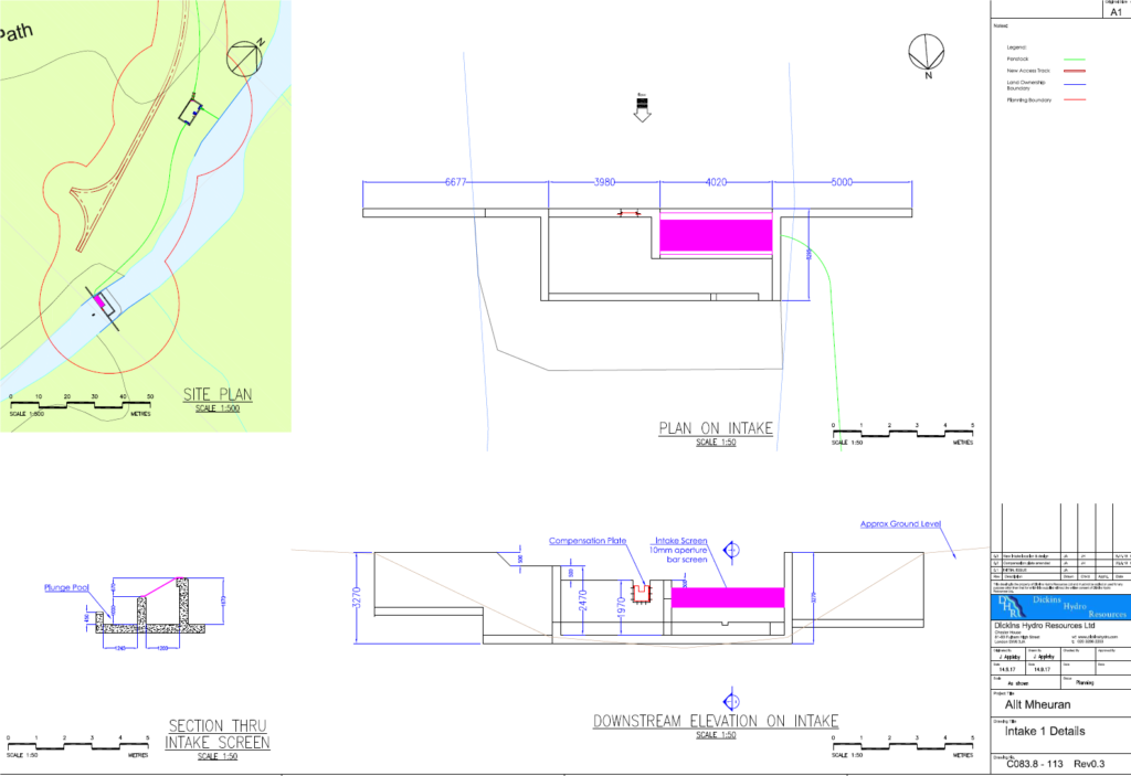
- While a new map has been added to the intake document dating from last year showing its location (along with what appears to be a permanent access track!) its unclear how the proposed design will fit in the proposed location, let alone how it will look. The size of any pool, the use of rip rap bouldering and whether the concrete walls will be faced in stone appear not to be considered.
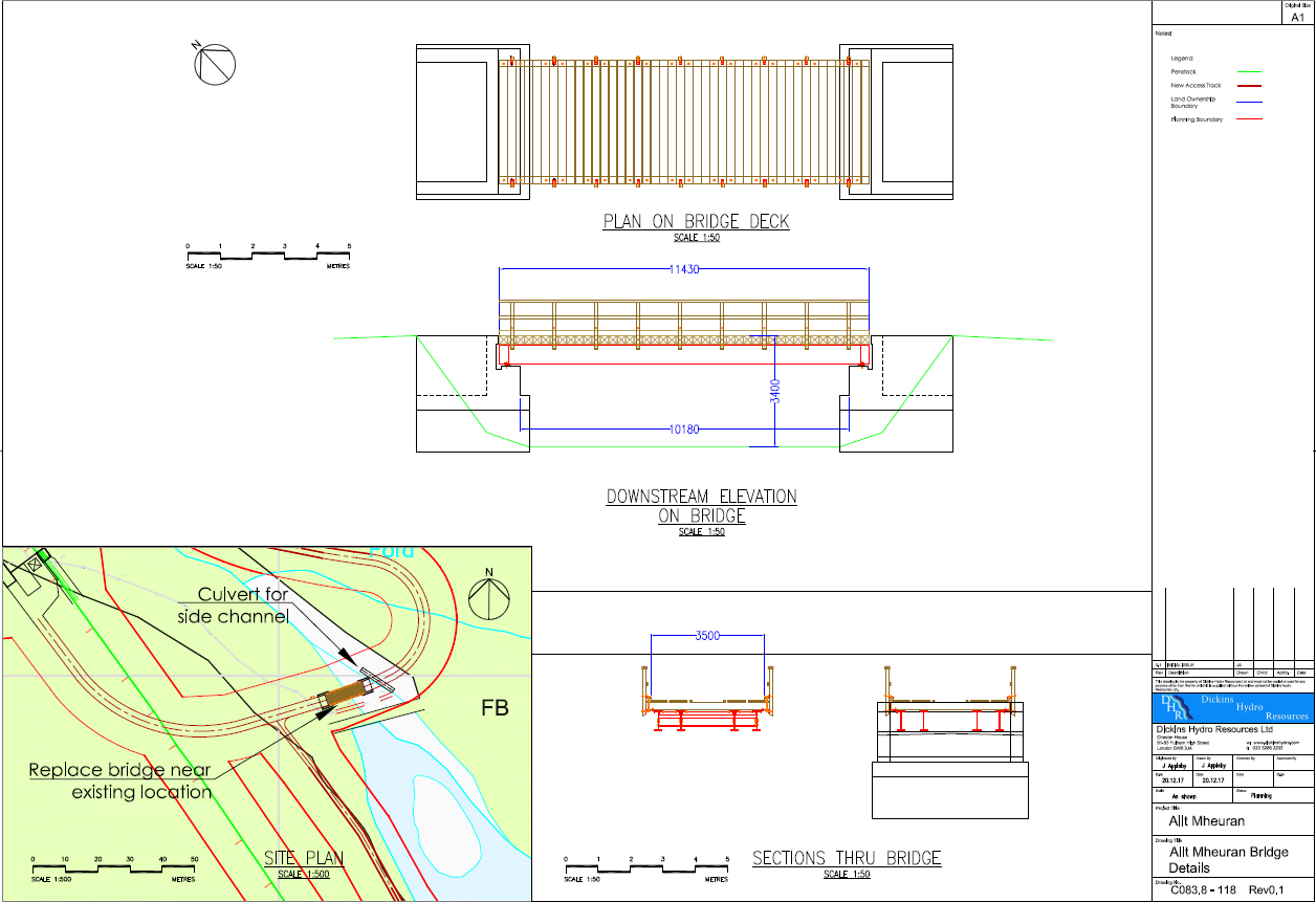
- Design details for the new bridge are also not supplied. The supporting pillars appear to be in concrete, totally out of keeping for Glen Etive
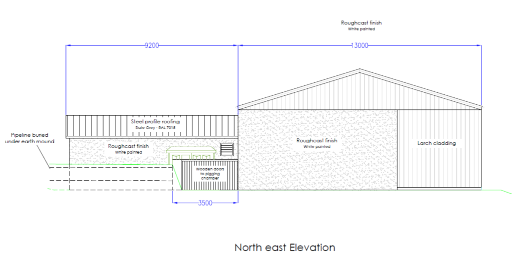
- The Powerhouse is in an open location, large and with a steel roof. Much of the walls will finished in white roughcast rather than natural materials. How is this appropriate for a National Scenic Area?
The revised proposal does nothing to ameliorate the impacts here and will signifcantly affect the beautiful open landscape.
While the glen above is even wilder, what leads there is an integral part of the recreational and wild land experience:
The Allt Mheuran needs to seen and treated as a whole and its integrity, and that of the National Scenic Area, preserved. The revised scheme does not do this. In my view it should be refused in its entirety.
The revised Allt Fhaolain proposals
This scheme (see here to comment) would have had a major impact of the Grampian Club’s Hut at Inbhirfhaolain and threatened to make it unusable both because of the noise from the powerhouse and impact on the water supply.
In the new application (see here for summary of changes):
- the powerhouse has been relocated north of the road bridge over the burn to Grid Ref 1575 5091 which is c150m from the hut
- the new powerhouse will part buried and fitted with noise insulation
- Dickins Hydro are proposing a water bowser during the construction period which they say they will re-fill once a week
- they will then install a permanent water supply to the hut (if the landowner agrees)
I am sure the Grampian Club will respond in more detail in due course (and put this on the hydrowatch Facebook Page) but it does appears many of the issues which impacted on the amenity of the hut have been addressed.
Significant landscape issues and questions, however, remain:
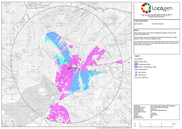
While the supporting documentation claims the Landscape Impact Assessment has been revised, the Assessment of Zones of Theoretical Visibility (Doc 5.6) still dates from December 2017 and still shows the powerhouse south of the road. While the powerhouse should now be less visible the assessment failed to include any consideration of the impact of the “upgraded” and new sections of access track on the landscape.
Unfortunately because Highland Council has not insisted there should be a proper assessment of the impact of tracks for the other Etive schemes the Developer appears to have felt under no obligation to provide this for the revised Allt Fhaolain scheme. That is NOT good enough and reason enough to object to this application.
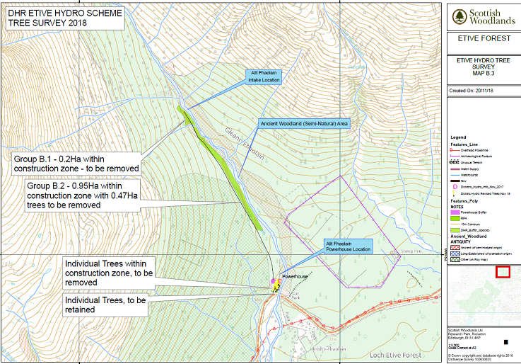
Ancient woodland runs along the Allt Fhaolain and the scheme will destroy some of this in its upper reaches, like the other schemes on the west side of the River Etive. There is still no proper assessment of the impact of these schemes on native woodland or on the scenery as the forest plantations are felled.
The existing “track is to be upgraded, including the replacement of any culverts that require it with bottomless culverts. A new access track is to be created from the existing forestry road to the intake. This will be reinstated at the end of construction to an ATV track”. Its not clear what the proposals to “upgrade” the existing forest track mean. Will it end up wider than at present? The phrasing of the application suggests it won’t be narrowed to ATV width. And why does the new ATV track need to be retained? Its only 150m long so turn it into a footpath. It would take 5 minutes for staff to walk it.
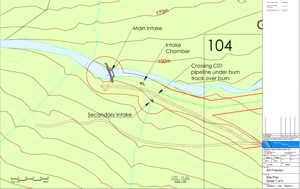
2.4 Intakes
Two intakes, a main intake and secondary intake, are proposed as part of the Development; both of which will be located on the Allt Fhaolain.
The main intake would be located at National Grid Reference (‘NGR’) NN 1540 5155, which is 149 m AOD, and would have a total width of c.27 m with the in river section being c.7.5m. The secondary intake will be located at NGR 15451 5149 which is 148 m AOD and would have a total width of 2.9 m. Both intakes would have coanda screens that are designed to allow the design flow to drop through and enter the stilling chamber and prevent silt and debris build-up from entering the penstock.
There are still, too, as far as I have been able to ascertain from looking at the planning documents, no proper designs for the main intake. This will be sizeable – 27m wide – and apparently constructed from concrete. Nothing appears to be said about how it will sit in the landscape, the size of the pool that will be created or the use of rip rap bouldering. All of these could have a significant adverse impact on the National Scenic Area.

Seems like a lot of techno jargon designed to confuse and therefore possibly appease the lay person. I will still be objecting to these schemes as a matter of principle,especially as approval could set a dangerous precedent re for example the proposed schemes in the Grey Corries.
Whatever post construction restoration or general environmental safeguards are included in the plan are only of importance if the are adhered to. It seems to me that a lot of developers don’t do what is promised re environmental mitigation as they are confident that no one is going to bother taking them to court if they don’t stick to the agreed rules. If developments like this have to take place, then it makes sense that planning permission is only granted if the developer gives a certain (fairly large) amount of money which would either be returned when restoration is completed, or used to pay for restoration work.
I am very disappointed that THC have allowed the developer to put forward these amended applications. There is no doubt in my mind that the Council is going to give consent to all the Glen Etive applications despite the very strong arguments put forward against them. If these proposals do go ahead, as I believe they will, the only course of action available is for individuals/clubs to visit the sites and carry out surveys to ensure the contractors/developer meet their contractual obligations and report any failures to THC.
Jim, I think you are right about how the Council is thinking at present but am optimistic they can be forced to change their mind. It needs lots of people to submit objections but also people to lobby local councillors, politicians, write to papers where ever there is the opportunity. Even though I have spent quite a bit of time now trying to raise awareness about what is wrong with the schemes I have spent a lot lot more time on the hills that will be affected! If every hill goer spent just 5% of the time they spent on the hills campaigning to protect them and our rights of access, we would be an amazing force! Nick
Amen to that. It’s shocking that so few hill goers bother to lift a finger. Not just for Glen Etive but everywhere. Grey Corries is another dismal example. THC planners clearly never go to the hills. I’m appalled that they could be contemplating such a desecration – and for such a tiny amount of electricity, too. To all hill folk out there: please get involved and stand up for these special places. If you don’t, no- one will. It’s time to give something back.
I realise that a neighbour of mine did some of the visual impact assessments for these schemes. Wait to I see him…….
I took advantage of a break in the shelling yesterday to e-mail Highland Council and complain that they had not notified obectors to the original schemes (the two discussed in Nick’s post) that new applications had been submitted. The reply tells me that a request WAS made for that information to be passed to those who had commented on the original applications, but that the request “did not make it” to the automated e-mail that was sent out! In any case, we are all supposed to read the “local press and the Edinburgh Gazette” and should therefore have known about the new applications AND the amendments to the EIA. Honestly, if you didn’t know any better you’d think this was all one big stitch- up in favour of the developer, but of course that can’t be true, can it now … ?
Sadly the work has started in Glen Etive and what a horrendous mess, I was up on Friday with my Son for some Photography and was very saddened by the sight of caterpillar tracked vehicles pretty much all along the full route to Loch Etive. Trenches being gouged at areas all along the road, I have loved this area for decades and am very saddened by this desecration of such a beautiful area.