Two separate planning applications have been submitted on behalf of Cairngorm Mountain Scotland Ltd (CMSL) to create new roads and tracks at Cairn Gorm both of which are currently being considered by the Cairngorms National Park Authority (CNPA). The first is for two new hill roads (see here for papers), the second is to develop “family friendly” mountain bike trails in the lower part of Coire Cas (see here for papers) . Both applications are so poor that they deserve to be rejected outright but they also have significant implications for the future of Coire Cas. In this first post I will consider the proposal to create two new permanent roads.
The base-station by-pass
The existing hill road starts between the funicular day station and the Day Lodge, which CMSL wishes to demolish (removing facilities for skiers), and passes under the funicular railway.

The Cairn Gorm masterplan, published last year, did show a new road around the funicular base station but did not explain its purpose:
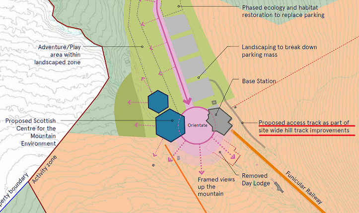
The first planning application contains no supporting statement and says nothing about the purpose of either of the two new roads. The first is almost certainly, however, linked to plans to move the snow factories (see here) up the hill and the low clearance where the current road passes under the funicular. While helicopters are very polluting, without any explanation of why the road is needed,it is impossible to evaluate its likely impact compared to such alternatives.
NatureScot’s response to the application, however, reveals they have been in discussions with CMSL about the road:
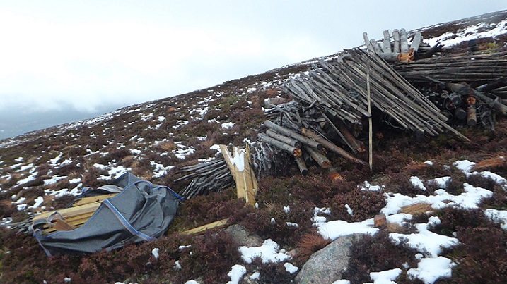
“We understand that the new track at the Base Station will supersede the existing Aonach all–
abilities trail [the start is shown in the photo above],which links the Coire Cas car park with the windy ridge footpath and mountain garden. This trail is specifically named in the current Cairngorm Mountain Ltd Visitor Management Plan as one which will be developed, maintained and promoted by Cairngorm Mountain Scotland Ltd (CMSL) as part of a range of measures detailed in the VMP to protect the European sites.
“CMSL have confirmed that the proposed new track will continue to allow pedestrian access
and therefore will essentially result in a widening of the existing Aonach all–abilities trail,
which will occasionally be used for vehicle access. Therefore this proposal is consistent with
continued implementation of the VMP as required by the S50 agreement, and we advise
there are no associated implications for the Cairngorms SAC and SPA.”
It appears therefore that CMSL is claiming that this new road is a replacement for the Aonach all-abilities trail which raises a number of questions:
- The application says nothing about how CMSL proposes to remove and restore the line of the current all-abilities trail? Unless the current road is removed, the by-pass is not a replacement but new.
- The by-pass will rise 55m to get round the Day Lodge and will be far steeper than the all-abilities trail, casting doubt about its suitability for use as an all-abilities track
- While I can find no detail of how the by-pass is to be finished, a surface suitable for all-abilities use in this location would increase its visual impact considerably.
- And in terms of the masterplan, why welcome visitors into the “orientation” area and then send them back to get onto the all-abilities path?
In truth, if the new road was really intended as a new all-abilities trail, it makes no sense.
There is nothing either in the Planning Application to describe the impact of the proposed new road on the Day Lodge Poma which starts just above the Day Lodge:

Depending on which map in the planning application you look at, the road variously passes below the Day Lodge poma drive, between it and the first tower and across the top of it!

It appears most likely that the new road, which will be over 4m wide, will pass above the Poma Drive as per the plan above. If that is the case, the clearance under the poma wires is even lower than the funicular railway so they would need to be removed each time a large load was taken up the mountain. Moreover, a larger flat area at the start of the lift would require the slope above to be re-profiled. There is no mention of this in the planning application which suggests that CMSL may now be secretly planning to remove the Day Lodge poma – which was shown as an “existing lift” in the masterplan – completely. That would fit with how CMSL has been replacing the old snow fences above the Day Lodge with a single fence.
In terms of the future of downhill skiing at Cairn Gorm this is more idiocy as CMSL should know from history. Back in 2004/05 CML, as it then was, decided the Day Lodge Poma would not run as part of its policy to retrench the business to focus on “core lifts”. Two years later, during the poor winter of 2006/07, there was insufficient snow to run the Carpark T-bar or Fiacaill Ridge Poma at any point in the season, the first time this had happened. However, the Daylodge Poma could have run for weeks because of the direction of the wind that had carried the snow. CML tried to portray their failure to run any of the lower tows as being down to the weather. This rightly caused uproar at a meeting with season pass holders, who had been deprived of skiing for a whole winter, and forced CML to recommission the Day Lodge Poma for the 2008 season.
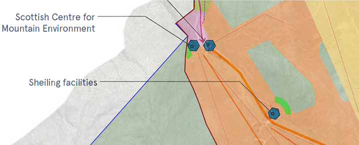
The Shieling by-pass
The second road in the track application, 120m in length, was granted temporary planning permission by the CNPA as part of the plan to repair the funicular but does not appear in the Cairn Gorm masterplan. CMSL now want to make the temporary road permanent but again provide no justification for this.

Unlike, the Day Lodge by-pass, however, the plans do show that two short sections of existing track will be removed.

The hydrology assessment suggests that any benefits are likely to be outweighed by the likely impacts of the proposed new road:
“The track follows the route of a temporary access track currently in place and constructed under the Funicular Strengthening works. This alignment was chosen to minimise environmental impacts (Plates 1 and 2, Appendix B refers). The design of this temporary access track which crosses peat comprises a sandwich of synthetic geogrid layers with well graded granular aggregate placed directly on the surface of the peat vegetation. The track has a reverse camber to allow surface water run–off to a constructed drainage ditch on the western side of the track and discharges into the wooded area at the base of the hill after the watercourse culverts below.
The new track will be composed of 200mm thick Type 1 sub–base over 300mm thick compacted rock fill. The finished track will be approximately 4.5m wide. The overall width footprint of the track including for ditches and embankments will be approximately 8m. This track has a c 10m extension track to a small additional proposed car park on the west at Chainage 70.”
Over peat (in places), 8m wide in total and with a new parking place thrown in for good luck!. What is CSML’s justification for this latest attempt to desecrate Cairn Gorm?
Ecological impacts of the two roads
CMSL lodged an ecological baseline report (see here) with Highland Council as part of the planning application before it was called in by the CNPA. That report, by Atmos Consulting and marked “sensitive confidential”, has not appeared on the CNPA planning portal.
The baseline survey minimises the ecological impact of the new roads but there is good reason not to trust it:
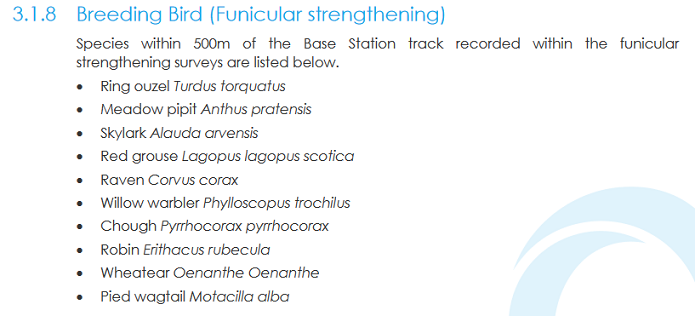
The inclusion of chough on the list of breeding birds that have been recorded for Cairn Gorm was either so exciting or so stupid that it needed checking, so I have: chough have never been recorded in Strathspey and the nearest population still appears to be on Islay!
The substantive ecological issue at stake is that you cannot keep building roads over a mountain without there being further ecological impacts. The fact that the areas concerned have already been modified does not change that. The important questions are the extent to which these new roads will result in a further deterioration of habitats at Cairn Gorm and why the CNPA, which granted temporary planning permission to the Shieling track to enable the funicular to be repaired, should now reverse its former stance that this area should be fully restored.
Contrary to what the hydrology assessment would have the reader believe, all hills roads affect drainage, promote water run off and increase rates of erosion, while the constant construction in Coire Cas keeps churning up mountain habitats.
Landscape impact of the new roads
The comments from the CNPA’s landscape team on the application are worth reading:
“As discussed last week, it’s not possible at this stage to assess the full effects of this proposal on
the National Park landscape due to insufficient information submitted. Notably, no detailed
description of the proposed development has been provided (although some aspects are
referenced within the hydrology and hydrogeology assessment), nor a landscape and visual
appraisal, or explanation of the design objectives.”
They have gone on to produce a list of information that is missing/issues that need to be considered. It starts with these four points:
a Description of routeing and design options considered, demonstrating how the proposed route minimises earthworks and represents the best option in terms of potential landscape and visual effects.
b The routeing of the track in relation to existing features including existing tracks, paths, burns, ski tows, buildings and the funicular, with consideration of collective effects.
c Proposed track construction materials and distinction of edges (to limit encroachment). The proposed aggregate grade and colour, and source of this. If aggregate is to be won locally, information on the siting, design and restoration of borrow pits.
d Proposed siting and design of any new fences, bollards or signs associated with the
proposed tracks.
Confirmation that the standard of this planning application is unacceptably poor.
What needs to happen
The CMSL Board might usefully ask their new Chief Executive how much she has spent to date on engaging consultants to develop the new roads proposals (FOI request to follow!). They could also ask how she then allowed such deficient planning applications to be submitted to the CNPA
The answer to the second question I believe lies in the masterplan.
Having earmarked some areas for habitat restoration, CMSL believes that it should be able to do what it likes to develop the rest of Coire Cas, without regard to landscape or ecology. There is further evidence for that in the planning application for mountain bike trails which I will consider in a further post. This is just wrong but also a fundamental mistake.
What is most likely to draw people to visit Coire Cas in future is the landscape and wildlife. This means there needs to be a restoration plan for the whole area and that issues relating to impacts on habitats and landscape need to be carefully considered before any proposal is developed. CMSL staff appear uninterested in this: the planning application records there was no consultation with the CNPA before it was submitted and the application deserves to be rejected outright. The bigger issue is that it should be clear now that the masterplan will do nothing to change how CMSL manage what they regard as their fiefdom and, as long as HIE owns the mountain, the sores will continue.

A great article, Nick. Your comments are a useful test on whether CNPA has wakened up to understand its role as Planning Authority, or whether it will continue to behave as being in the pocket of CMSL and HIE. I fear that CNPA will again continue to fail to live up to its role as Planning Authority……but I would be very happy to ‘eat my words’.
Great Article thanks