Watching the torrential rain showers in Glasgow over the last ten days, I have been wondering about what impact they have been having in hills, both in our National Parks and more widely.
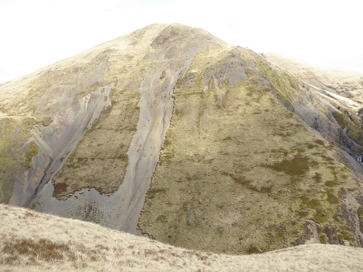
Erosion is a natural process but the impact of increased heavy rainfall due to climate change on eroded slopes such as that pictured above should be obvious. My OS map 79, dating from 1985, shows two separate erosion features half-way up the slope: they have now joined at the bottom and reach almost to the top. The isolated clump of turf at the top of the right hand erosion feature, and the jagged line of turf running down its right-hand side, show how the vegetation is being stripped away. Much of the left hand feature has now eroded back to the bedrock and the erosion runnels on the right hand feature show it’s only a matter of time before this happens there too. Maybe one downpour will be sufficient?
The horizontal lines across the vegetation almost certainly mark former pathways used by grazing animals (one would need to walk over the slope to be 100% sure). The erosion features have now cut off access to grazing animals and that is enabling the vegetation, marked by the darker patches, to regenerate (particularly noticeable on the shoulder to the right). Whether this will prevent the whole of this slope eroding back to the bedrock remains to be seen.
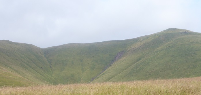
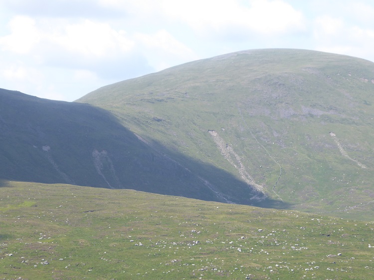
Whenever I go into the hills now, I look for landslips and, particularly on grassy hills, heavily grazed by sheep or deer, I expect to see them (photo above).
Where a landslip has occurred, it should be obvious that the land is particularly vulnerable to further erosion and extreme rain events. A very good example is at the Rest and Be Thankful (see here), where Transport Scotland is now having to close the A83 when high rainfall is predicted (twice in the last few weeks – see here). Despite publishing a landslide study in 2005 (see here), they failed to act and let the grazing continue. That should serve as a warning to us all and particularly to those bodies responsible for holding landowners to account for the way they use the land: NatureScot; our National Park Authorities; the Scottish Government.
What I had not appreciated until I observed the landslips off Glen Banchor a few weeks ago (see here) was that one isolated cloudburst after a not particularly wet period could trigger so many new landslips. I had assumed that most of the landslips I have been observing were triggered by longer rain events, a few hours at least. It seems that the land is in an even worse state than I had thought.
Unfortunately, the powers that be still have their eyes closed and most of the people responsible probably never go into the hills. Despite the Rest and Be Thankful and despite all the coverage parkswatch has given to the landslides around Loch Katrine and Glen Falloch, see here and here for example, Loch Lomond and Trossachs National Park Authority have never discussed them at a Board Meeting and have never, to the best of my knowledge been to visit them (there is so much secrecy you can never be quite sure what the LLTNPA actually do do) . Boards appear to find it much easier to discuss anodyne papers on climate change on Zoom (convenient for the two LLTNPA Board Members who live in England) rather than witness at first hand the impact of the worsening climate and environmental crises.
Part of the reason organisations like the LLTNPA and the Scottish Government still get away with this is lack of data. “Scotland has had 20 major landslips in the last two weeks and 120 in the last year” might hit the headlines. But at present we don’t have that information. The only organisation I know that is making a serious attempt to study the problem is the British Geological Society which has a database on landslides (see here). A quick look at their online map shows that not a single one of the landslips featured in this post are currently on their data base. In fact, in the core Galloway Hills only five are recorded in total. There are that many in the photo I took of Kirriereoch a couple of weeks ago! In fact I have seen three times that many this year in Galloway alone…………………..
That is where citizen science and you, the reader, can help. If you see signs of a recent landslip, take a photo and the grid reference and send this to landslides@bgs.ac.uk . While its worth checking the BGS on-line map before doing so, even if its an older landslip and has already been recorded, recent photos may help scientists work out whether the initial area affected by a landslip is expanding. The more landslips are reported, the harder it will be for our politicians and public authorities to ignore what is going on and the easier it will be to make the case for research and action to tackle the way land in Scotland is being mis-managed at present.
Both our National Park Authorities and Forest and Land Scotland should be assisting with the research. The LLTNPA Ranger Service, for example, drives every day past sites where I have seen evidence of recent landslips, but there are no signs of those being logged on the BGS database. Our National Park Authorities could also be helping fund research with their climate emergency monies. Citizen science data can help show them up so and shame them into action so, if you are going for a walk in the hills, please record landslips and report them to BGS. And, if they are in one of our two National Parks (or even if not), I would be very interested in seeing them nickkempe@parkswatchscotland.co.uk .
More on the landslips that have been taking place in the Loch Lomond and Trossachs National Park soon!

Hi Nick. Another excellent post on landslips. As you note, part of the problem is the lack of data which has been evident since at least the 1990s. You wrote quite rightly “That should serve as a warning to us all and particularly to those bodies responsible for holding landowners to account for the way they use the land: NatureScot; our National Park Authorities; the Scottish Government.” This highlights another very significant part of the problem. Even if good data was available would these bodies actually ‘hold landowners to account’? In my opinion, there is little or no evidence that they are serious about doing this in any meaningful way whatever the evidence (for example deer management).
oh, dearie, dearie me, here we go round the deja vu, groundhog day, square one, grazing-burning destructo-go round again http://www.andywightman.com/archives/3291
Thanks for the link Ron, I recommend to other readers they should read your article. We need to keep making the arguments and support other people who are doing the same.
indeed, yes.
As you know, Nick, Derek Pretswell and I have been banging on about the erosion problem for many years and illustrating it with examples from the Drumochter area and using analogies with Iceland and Norway. I’ve used the Facebook facility to post some of the photos. As our erosion graph showed, as it gets worse, it gets worse faster.
Given the increased frequency of heavy, slow moving, very local downpours thanks to warmer air carrying more moisture, a fall in the temperature gradient of the North Atlantic Conveyor ( aka Gulf Stream) and the changing locations of the Jet Stream we are going to see more land slips annually.
Edinburgh’s had its own famous landslip, the Guttied Harddie, above the well used footpath from the junction of Holyrood Park Road and Queen’s Drive to Arthur’s Seat. Historic Scotland ( as HES then was) did some ground stabilising and drainage work around it some twenty years ago after I alerted them to the fact that a crocodile of ESL students from Pllock Halls of Residence could be swept to their doom if the Gutted Haddie became plastic again after a heavy rain fall.
I fear that it may take the loss of life before other parks authorities and local authorities start to collect and collate data on unstable land for which they have responsibility and instruct landowners to reduce grazing pressures and encourage the regrowth of soil stabilising plants.
Erratum: For “Harrdie” read “Haddie”.
If you compare the 1:25k and the 1:50k maps for this scar you’ll see that it’s not marked on the former and just indicated at the foot of the slope on latter. I don’t know the date of the latest updates for these maps nor how detailed such updates are but the copies I’m referring to are from the OS Maps subscription website which are updated from time to time, not from well worn paper copies at the back of cupboard. The dates of the maps would give a rough timescale over which these changes have taken place.
I’m observing small addional slides to existing erosion scars and one or two significant turf slides at the end of each winter at Carrifran and Talla & Gameshope across the Moffat valley from here.
Thanks John, it would be very interesting if the good folk involved in the Carrifran Wildwood project and other re-wilding projects in the Borders were to start monitoring what is happening on their land compared to other land neearby used for intensive forestry and sheep grazing. While it will take time for the land to restore over time, I would expect to see significant differences emerge.
In most of upland Scotland these landslips are a consequence of climate change combined with excessive burning and overgrazing of the hills. Various attempts by successive governments, since the 1950s, to regulate these activities have failed. This is in part due to lobbying by the Royal Family, notably in relation to deer and grouse moor management and their own private interests in Deeside. Climate change was not a problem when Queen Victoria was on the throne – how are we going to explain to the COP 26 delegates that land use practice on Balmoral and other estates in Scotland has not evolved sufficiently since the 1800s and is in no way fit for purpose in meeting today’s climate change challenges?