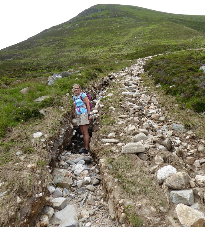
Late last Friday afternoon I went for a walk up Glen Banchor and over Creag Liath, via the track by the Allt Fionndrigh. The track featured on Parkswatch 18 months ago due to the Glen Banchor and Pitmain estate’s plans to extend it for the purposes of grouse moor management (see here). All the ground featured in these photos is part of the Monadliath Site of Special Scientific Interest (SSSI) (see here for details) and Monadhliath Special Area of Conservation (SAC), while the Allt Fionndrigh is part of the River Spey SAC. Designations intended to put conservation first.
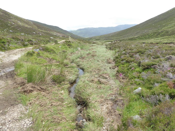
About 3km along the track, just past Creag na h-Iolare (NH 666015), we came across recent flood damage.
I was not that surprised as ten days earlier intense but localised rainfall had been forecast. I had also had heard from two people I know that that day two inches of rain had fallen in Grantown on Spey, the heaviest downpour they had ever experienced. But it took me a couple of minutes, by which time we had moved a little further up the glen, to work out why the flood was above the main river. It had originated from up the hillside, rather than up the glen, and was associated with a large landslide.
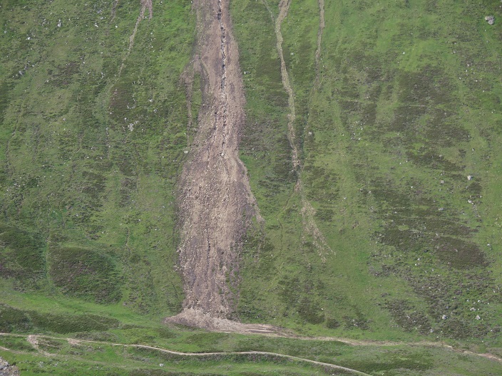
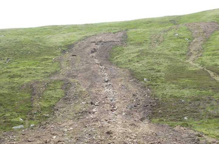
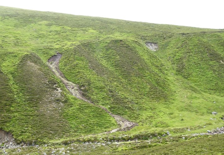
The scale of the landslide and the damage that been wrought to the hillside became evident as we got closer.
Alongside the large landslip were a number of smaller ones.
The top of the main landslip was marked by the equivalent of a half depth avalanche which had swept down peaty soils across a front 10-20 metres wide:
Below the shear-line the former drainage line down the central axis of the landslip had been gouged out down to the glacial till below. It had formed a new burn which was still trickling. This sudden erosive event has removed significant quantities of peaty soils which have been storing carbon and retaining water, possibly for for thousands of years.
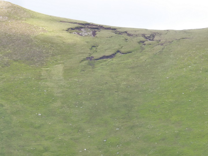
There is a peat bog at the top of the slope immediately above the landslip but this appears severely eroded. Had this bog been in better condition, might the damage from the rain event been reduced, or even avoided completely?
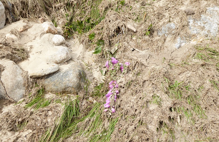
Flowers caught up in the debris provided evidence that the landslip was very recent.
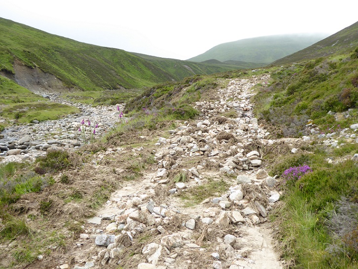
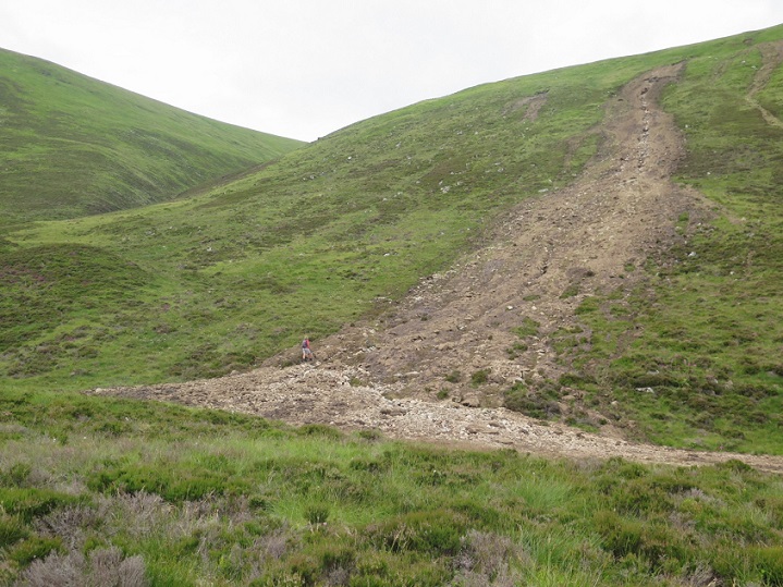
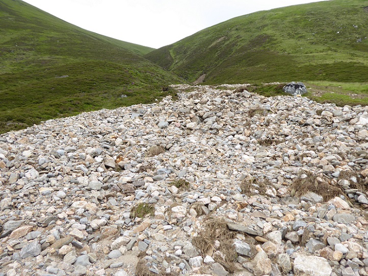
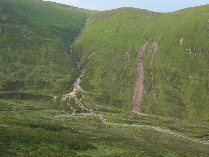
Just beyond the landslip, the former track was covered in debris. It then turned uphill to cross the burn that drains the southern slopes of Geal Charn, a subsidiary top of the Munro A’Chailleach.
What had happened is the burn had partly diverted down the line of the track from former crossing point, gouging it out in the process. The force of water that created this must have been extraordinary. It would have been amazing, but very frightening, to watch.
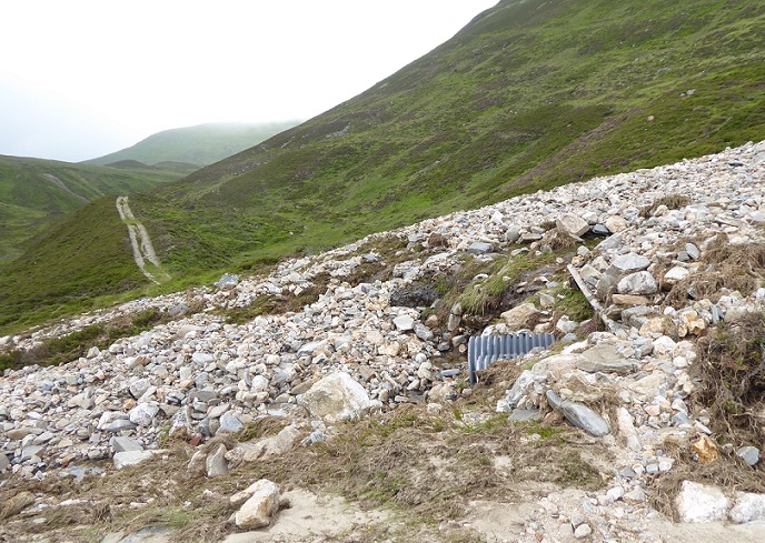
The former crossing point had been completely overwhelmed with boulders disgorged from the gully above.
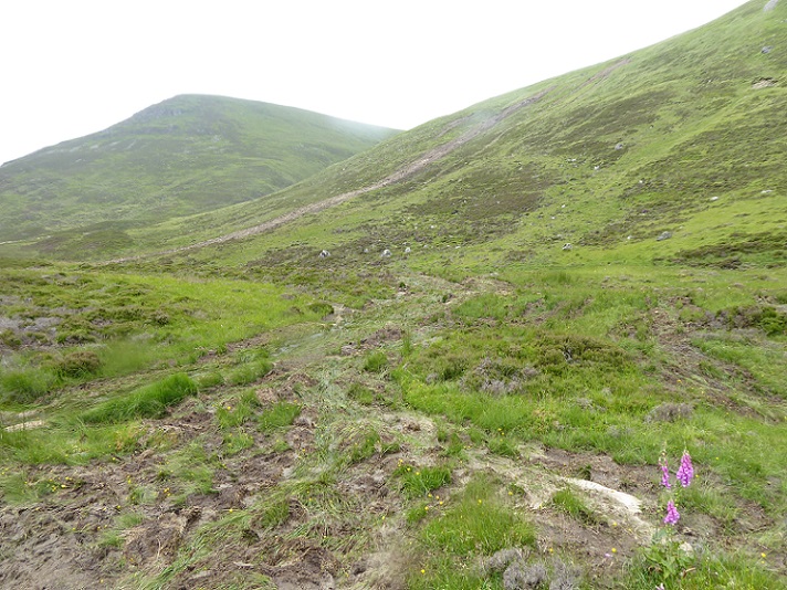
The gutted gully and the largest landslip were in close proximity, but nearby there had been other significant landslips.
Evidence from the photos suggests that most if not all of these landslips have been triggered by the recent extreme rain event. Rainfall alone, however, is not responsible.
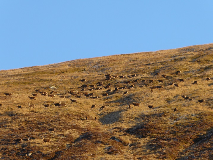
When I had walked up the Allt Fionndrigh track in November 2019 there were dozens of deer on this hillside:
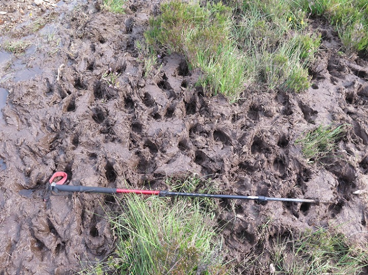
The mud deposited by the landslips was covered with red deer hoof prints:
Discussion
The evidence strongly suggests that high population of red deer has been one of the main causes of the environmental degradation that has made these slopes so vulnerable to climate change. Deer have trampled the hillsides, munched the vegetation that might have helped hold these slopes together and helped erode the peat bog above.
Erosion is a natural process which has moulded the Highland landscape and landslips have historically played a significant part in this. However, their incidence and scale reduced as vegetation colonised the land after the ice receded. You can see evidence of landslips from the not too distant past on the right of the overview photo above. But their scale and impact is dwarfed by those that took place recently. It’s the same in the Loch Lomond and Trossachs National Park, whether at the Rest and Be Thankful (see here), Glen Falloch (see here) or Loch Katrine (see here)where large areas of hillside have been torn apart by recent extreme rain events.
A combination of climate change and environmental degradation means its only a matter of time before something really catastrophic happens in Scotland, such as the recent flood and landslip destruction in Germany and just before that the Atami mudslide in Japan (see here). Imagine what might have happened if instead of a small localised extreme rain event, that only affected a small part of Glen Banchor, such rain fell over the whole of the upper Spey catchment. The consequences downsteam could be terrible.
The Cairngorms National Park Authority and NatureScot, responsible for protecting SSSIs and SACs, have sadly sat on their hands when it comes to reducing deer numbers. With climate change, we cannot afford to spend years in endless negotiations with “sporting” estates about how to reduce deer numbers voluntarily and rely on the actions by estates being managed for conservation purposes to protect the land and us from the impacts of climate change.
What has happened in Glen Banchor should be sufficient for the Scottish Government to instruct NatureScot to use the powers it has under Section 8 of the Deer (Scotland) Act 1996 (see here) to force the estates in the Monadliath which are managed for “sporting” purposes to reduce deer numbers. Over the hill in the upper River Dulnain catchment, those high numbers of Red Deer descend the glen when the weather is bad and start feeding off the regenerating Caledonian Pinewood at Kinveachy undermining the work that is being done there to provide more habitat for the capercaillie which once again faces extinction. The landslips around the Allt Fionndrigh provide more evidence of the urgent need to change how sporting estates manage land in the Cairngorms.
Note
After my walk, I showed my photos and described what I had seen to Dave Morris. He walked up the glen the next day to take a look for himself so the photos were taken on two different days.

The owner of this land appears to be the chief executive of a private oil company based in the Middle East. The neighbouring estate appears to be owned by members of the Qatari Royal Family. Such far away owners, who control all the mountain and moorland between Kingussie and Laggan in Badenoch, decide the size of the deer populations in large tracts of the headwaters of the Rivers Dulnain and Spey. They appear to be oblivious to the damage being done by excessive deer and sheep grazing pressure in these uplands and the threat this poses for downstream communities and the ecological restoration efforts that should be a key part of Scotland’s climate and biodiversity recovery efforts. An immediate compulsory programme of deer population reduction, assisted by military personnel with helicopter support, is the only way this problem will be solved. Nature Scot cannot achieve this on their own.
venison burgers – yummy
“One of the penalties of an ecological education is that one lives alone in a world of wounds. Much of the damage inflicted on land is quite invisible to laymen. An ecologist must either harden his shell and make believe that the consequences of science are none of his business, or he must be the doctor who sees the marks of death in a community that believes itself well and does not want to be told otherwise.”
― Aldo Leopold, A Sand County Almanac
I fully agree that erosion is an ongoing process and that events will always happen, especially in times of extreme rainfall, however it doesn’t take much understanding to realise that with the overgrazing of our uplands, combined with muirburn, (all man made effects) that the frequency of these events must increase, and that’s before issues of climate change are considered.
It’s just a matter of time before another significant landslip/erosion event happens in Coire Cas, given widespread and ongoing excavation work to ‘repair’ the funicular. Another area that I have seen increased erosion in recent years in my travels up and down the A9 is just south of Glen Banchor on the slopes of the Sow of Atholl (Meall an Dobharchain). The hillside facing the road used to be relatively smooth, now it is cut by new flood streams and erosion debris further down the slopes. Again overgrazing is clearly the culprit.
Hi Gordon, I don’t have any recent photos of the Sow of Atholl to refer to but there was a section of the face which looks onto the A9 which used to avalanche very regularly and which then stood out in summer as some of the vegetation had been removed. I am not sure if this is the same ground as that you are referring to but, if so, avalanches may have been an important contributory factory. Though of course, if we had a montane scrub zone in Scotland, that would help reduce the damage done by avalanches and the lack of such a zone is almost entirely due to overgrazing! So, while overgrazing may well be the most important fact in the erosion on the Sow of Atholl, its complicated by the way snow accumulates in certain places which then become very prone to avalanches and avalanche damage. Nick