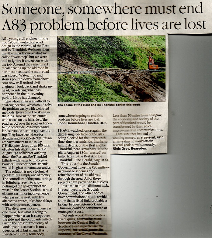
Last Tuesday, almost exactly a year after the large floods that caused so much destruction in Glen Falloch (see here), torrential rain triggered another massive landslip on the slopes of Beinn Luibhean closing the A83 and the old Military Road below the Rest and Be Thankful. This post argues that the Scottish Government’s tinkering option for A83 is never going to work and is likely to end in tragedy.
The landslip and the Plan for the Rest and Be Thankful
The Scottish Government has now been working on a plan for the A83 at the Rest and Be Thankful since 2012 (see here). While estimates seem to vary, between £80-100m has been spent on landslip defences, comprising wire netting on the slopes above the road and catch pits. They clearly haven’t worked.
The catch pits this time are estimated to have trapped 2000 tonnes of debris but a further 1,500 tonnes flowed over the road while 6000 tonnes of debris is estimated to have moved in all (see here). If this is right that would appear to leave 2000 tonnes on debris on the slope above the road poised to go………..while safety systems have apparently been put in place the people working on the slope stabilisation have my utmost respect. There is no mention in the media reports of the A83 being closed beforehand because of the forecast of heavy rain and it appears j a matter of luck that no-one was killed. As the Herald headline implied, it is time someone took responsibility or people were called to account, as in Beirut.
According to the minutes of a meeting of the A83 Taskforce, the group set up to co-ordinate actions, held in November 2018 after a major landslip a few weeks earlier:
“After 48 hours of intensive rainfall (150mm), a landslide overnight into Tuesday 9 October 2018 closed the A83 Rest and Be Thankful until its reopening at 11.20am on 18 October. Over these 9 days, the strategic diversion (via the A85) or the local diversion (via the Old Military Road) were in place. This was the biggest landslide (3,200 tonnes in total) on the Rest and Be Thankful in at least a decade”
This latest landslip was almost twice as large as the last one and this time, according to the Scottish Environmental Protection Agency’s rainfall guage at the Rest and Be Thankful, there was less rain. A mere 87mm, but in a much shorter period:
The initial response from Transport Scotland, according to the newspaper reports, is to dig even bigger catch pits It won’t work, but it also shows the engineers know the whole of the lower section of the slope on Beinn Luibhean is unstable. I am not an engineer, have little idea of quantities but there must be tens of thousands of tonnes of debris on the slopes above the road. There needs to be another engineering solution, either shelters over the road – as in the Alps – or a tunnel. Only the latter would protect the landscape character of what is a very historic pass in the National Park.
The most recent published minutes of the A83 Taskforce date from June 2019 and were published in January 2020 (see here). Perhaps there was a further meeting around January, which might explain why the minute was published then, but if so no minute has been published and there is no further public information available from Transport Scotland about the state of the current plans for the Rest and Be Thankful. Forest and Land Scotland, to their credit, did put out a news release in May about the further landslip that had taken place in forestry, in January 2020, saying those problems had been addressed (see here).
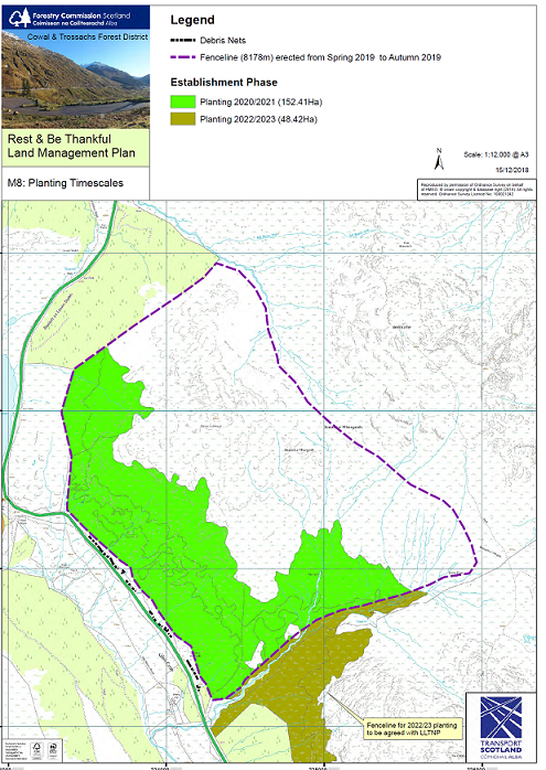
Meantime, while it can’t and won’t address the problems in either the short or medium term, it’s not clear what has happened with the plan to plant the slopes of Beinn Luibhean. A planting trial was agreed in 2017, to see if this would stabilise the slopes, and then a planting scheme agreed which was due to start in 2018. This appears to have been delayed because of delays in purchasing the land.
According to the latest information on the FLS website fencing was due to be erected last year and planting was due to start in 2020-21.
I did not see any sign of the fencing last year and cannot see any in the latest photos of the landslips. Moreover the planting plan is STILL listed as an active consultation on the FLS website (see here). It’s not clear therefore that anything is happening that might help stabilise the slope in the long-term. Perhaps Forest and Land Scotland need new powers to take over land more quickly than is possible at present?
Why no urgency with the Climate Emergency?
I had half intended to go and take a look at the Rest and Be Thankful on Saturday but went to Glen Falloch instead to look at the hydro schemes. There is a SEPA guage to measure river levels at Inverarnan and the data since 1970 shows that peaks of 2.8m and above occurred in the following years: 1978, 1986, 1991, 1999, 2006, 2012, 2014 (previous maximum- 2.961), 2015. All of these were within 30 cms of the August 2019 which caused such destruction. The river level last week again topped 2.8m, which prompted me to visit.
Although the evidence at Glen Falloch clearly shows these extreme rain events are increasing, I ws relieved to find that with the bridge over to the Ben Glas farm campsite repaired, there was no evidence of new CATASTROPHIC damage from the rainfall last week. There was, however, plenty of evidence that the rainfall did have some further serious impacts on the hydro schemes there (see here) and will return to these in a further post. These extreme rain events, while becoming more common, are quite localised and it is likely there was less rain in Glen Falloch than the Rest and Be Thankful. Interestingly, however, a record high of 0.8m was reached in the Eas Daimh (a tributary of the Orchy) just to the north. This equaled the highest ever recorded in Feb 2019, just 18 months ago!
What I did witness on Saturday, however, was further evidence of catastrophic damage in Glen Falloch which appears to have been caused by the floods in August last year. I cannot find any references to this damage in the media even though it was visible along the West Highland Way and must have been seen by many people. Perhaps people have not realised what they were seeing?
I only realised that this wash out of the West Highland Way must have been caused last August – what has the Loch Lomond and Trossachs National Park Authority done since then? – when I reached the missing bridge:
Looking back down Glen Falloch. Note the material eroded out from behind the pillar
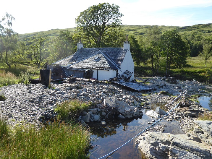
The really chilling bit came at Derrydarroch, where the West Highland Way crosses the river.
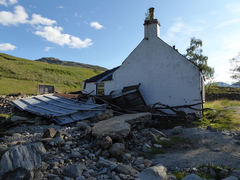
Derrydarroch Cottage was, until this happened, in an idyllic location. The fact that a cottage has been here so long but has now almost been seriously damaged and the more ricketty structures around destroyed, shows this flooding was unprecedented.
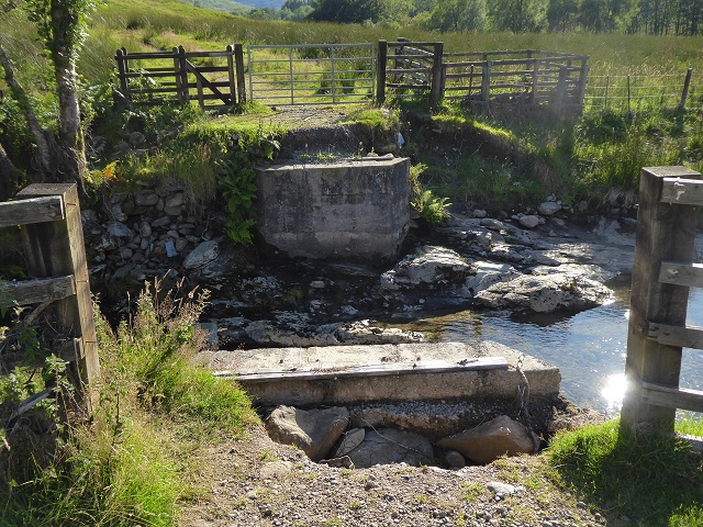
I wondered where the large concrete slab in the foreground had come from but then went to the bridge:
On the left hand side you can see a missing section of concrete slab. The trees in the railings indicate something of the height and the force of the flood. Maybe, however, the slab simply cracked, was unsafe and has been removed and dumped lower down by tractor (although there are signs on the bridge saying its unsafe to vehicles)?
Possibly, but I also noticed this very clean slab propped against the side of the tributary by the house. It has not been there for long and my guess is it was moved there by the floods last August. Awesome but also chilling for anyone in Scotland who lives in a nice cottage by the banks of a burn.
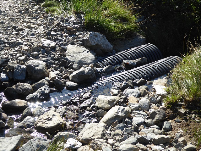
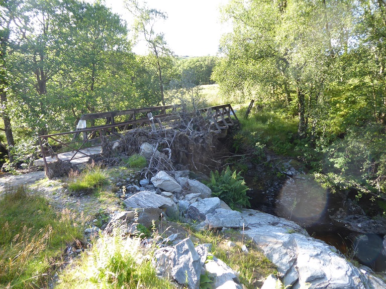
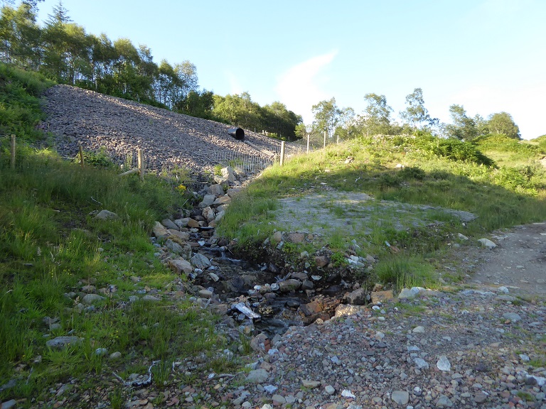
Further up the extent of the road/path that has been swept away is nicely indicated by the hanging culvert.
In the foreground you can see that some of the debris from the embankment was used to repair the West Highland Way. An embankment debris flow runs below the photo down to the banks of the river.
Some repair works, its hard to tell how much, have also been carried out to the railway after debris from this embankment was washed down to the edge of the River Falloch. A reminder that its not just on the A83 that travellers are now at risk in heavy rain.
What is incredible, given the extent of this damage and the potential risks to human life, is that the Loch Lomond and Trossachs National Park Authority Board has completely failed to consider the implications of this flooding, either for humans or for the way the natural environment needs to be managed in future. There are parallels to the people sitting on the ammonium nitrate powder keg in Beirut and, before the LLTPNA claims this is not their responsibility, they are directly responsible for the West Highland Way but don’t even appear to have considered plans for how to repair that.
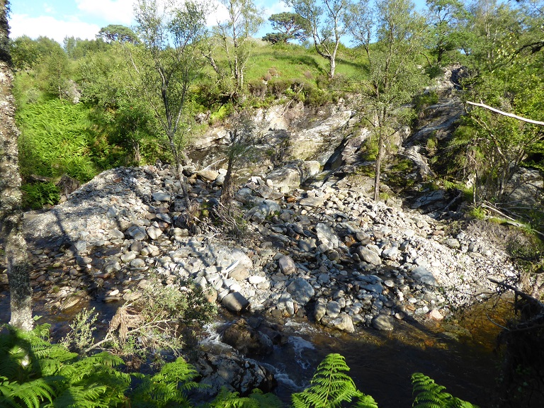
In most places much of the debris brought down by the floods has disappeared, re-distributed along the river system or spread along the banks. It’s hard to get a sense of volume but I came across this, not far above Derrydarroch. It illustrates such how much debris sits on one small section of bank.
What needs to happen
Increasing extreme rain events coupled with longstanding degradation of the water retention capacities of the natural environment (through destruction of peat and trees and developments such as hydro schemes that increase the rate of water run-off from the hills) means that a large part of the National Park is in serious trouble. The Scottish Government should need no more evidence to show that its plans for the Rest and Be Thankful are doomed. It must start a strategic re-think of the road now, within the context of a much wider review about how it is going to reduce the increasingly catastrophic impact of floods in the National Park and Scotland more widely.
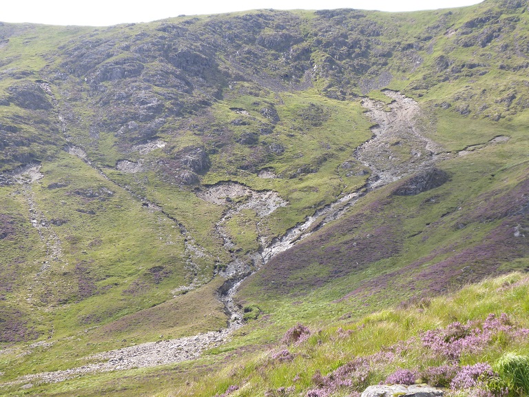
And, just to illustrate that this is a Scotland wide issue, here is a recent photo from Corserine, in Galloway Our post-glacial landscapes, instead of accumulating soils – however thin – as they did for hundreds of years, are instead being eroded at ever increasing rates
3 Comments on “Landslides, climate change, environmental degradation and the A83”
Quite shocked by the photo of Corserine, though perhaps shouldn’t be. I climbed Meikle Millyea from the south west on Sunday looking across to Coresrine and could only see the top section of this. There have been similar issues in the Lakes with the worst being 2015 when the landslide on Dunmail Raise cut the northern lakes off from the south. Hundreds of smaller examples could also be seen. I understand that it’s not necessarily an overall increase in rainfall that’s the problem but an increase in the intensity of particular events. One flood risk professional described a certain lakes catchment as a bomb waiting to go off. I suspect it’s the same for many catchments in the southern and western highlands.
Correction ! just realised that I was looking at Milldown rather than Corserine from Meikle Millyea – a similar effect to that on Corserine, though on a much smaller scale. Only my second hill orientated visit to Galloway but I have to say these are great hills and certainly the place to get away from the crowds.
There has been a train of thought encouraged by UK media press reports: Storms, tsunami, tidal surges and flood events must be ‘engineered’ around. It would have us believe Hills and Coasts, river valleys and even bog land are all fixed features. Under this ‘logic’ measures should be taken by planners to ensure that what the map shows will be the fixed position for all time. Huge tranches of public money are fought for so local vistas may be conserved “as is”.- Vast engineering assembled to protect those whose property might be affected when things shift.
Elsewhere people who live in more mountainous regions of the world, in the coastal regions where hurricane and Tornado,Mistral and Typhoon repeatedly ravage communities all understand this better; nothing is permanent.
With regard to the ‘Rest and be Thankful’ pass. Over 50 years ago the first very long tunnels were driven through under the Alps. Today multiples of these feats of far- sighted engineering permit road traffic on autobahn sized roads to “by pass” the peaks. It is as if Politicians in charge of funding for British infrastructure wear blinkers. There appears a miindset that if some engineered solution has not first been attempting within the UK it is not worth considering. Years ago I was told by a DoT engneer that funding arrangements mean more can be spent repairing, widening and reworking existing structures. This is because fiddling with things is not seen by the treasury as a “capital” ( – read “inflationary”) cost. Scottish transport ministers should have the imagination to put an end to this. Put these senior road engineers and planners in a bus ( Covid or not) and take them on a 3 star 7 day coach tour to view these Swiss French and Italian structures for themselves. There has been nothing to prevent a new 600 mtr length of Rest and be Thankful roadway on “stilts” being built past the affected segment of the hillsides. A concrete roadway could be supported on tapered pillars founded on bedrock, between which mountain debris would slide past. Any engineer who has seen the 2.6 km bridge west of Geneva on the A 40 across a seriously undercut and eroding landscape above the Rhone should never forget what is now technically possible. The coach trip for these planners would be a lot cheaper than digging fresh catchment holes to collect millions of tonnes of fresh spoil from every year. After wasting £70 million attempting to instruct an eroding hillside to stop interfering with ,a permanent example of the correct fix is there for Scottish planners to adopt. Even someone as powerful as King Canute did not get lucky when faced with inevitability. Instead of attempting the impossible, be bold : copy proven techniques used by the Swiss Italian and French engineers.

 On the left hand side you can see a missing section of concrete slab. The trees in the railings indicate something of the height and the force of the flood. Maybe, however, the slab simply cracked, was unsafe and has been removed and dumped lower down by tractor (although there are signs on the bridge saying its unsafe to vehicles)?
 Possibly, but I also noticed this very clean slab propped against the side of the tributary by the house. It has not been there for long and my guess is it was moved there by the floods last August. Awesome but also chilling for anyone in Scotland who lives in a nice cottage by the banks of a burn.
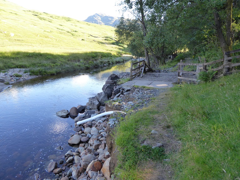

Quite shocked by the photo of Corserine, though perhaps shouldn’t be. I climbed Meikle Millyea from the south west on Sunday looking across to Coresrine and could only see the top section of this. There have been similar issues in the Lakes with the worst being 2015 when the landslide on Dunmail Raise cut the northern lakes off from the south. Hundreds of smaller examples could also be seen. I understand that it’s not necessarily an overall increase in rainfall that’s the problem but an increase in the intensity of particular events. One flood risk professional described a certain lakes catchment as a bomb waiting to go off. I suspect it’s the same for many catchments in the southern and western highlands.
Correction ! just realised that I was looking at Milldown rather than Corserine from Meikle Millyea – a similar effect to that on Corserine, though on a much smaller scale. Only my second hill orientated visit to Galloway but I have to say these are great hills and certainly the place to get away from the crowds.
There has been a train of thought encouraged by UK media press reports: Storms, tsunami, tidal surges and flood events must be ‘engineered’ around. It would have us believe Hills and Coasts, river valleys and even bog land are all fixed features. Under this ‘logic’ measures should be taken by planners to ensure that what the map shows will be the fixed position for all time. Huge tranches of public money are fought for so local vistas may be conserved “as is”.- Vast engineering assembled to protect those whose property might be affected when things shift.
Elsewhere people who live in more mountainous regions of the world, in the coastal regions where hurricane and Tornado,Mistral and Typhoon repeatedly ravage communities all understand this better; nothing is permanent.
With regard to the ‘Rest and be Thankful’ pass. Over 50 years ago the first very long tunnels were driven through under the Alps. Today multiples of these feats of far- sighted engineering permit road traffic on autobahn sized roads to “by pass” the peaks. It is as if Politicians in charge of funding for British infrastructure wear blinkers. There appears a miindset that if some engineered solution has not first been attempting within the UK it is not worth considering. Years ago I was told by a DoT engneer that funding arrangements mean more can be spent repairing, widening and reworking existing structures. This is because fiddling with things is not seen by the treasury as a “capital” ( – read “inflationary”) cost. Scottish transport ministers should have the imagination to put an end to this. Put these senior road engineers and planners in a bus ( Covid or not) and take them on a 3 star 7 day coach tour to view these Swiss French and Italian structures for themselves. There has been nothing to prevent a new 600 mtr length of Rest and be Thankful roadway on “stilts” being built past the affected segment of the hillsides. A concrete roadway could be supported on tapered pillars founded on bedrock, between which mountain debris would slide past. Any engineer who has seen the 2.6 km bridge west of Geneva on the A 40 across a seriously undercut and eroding landscape above the Rhone should never forget what is now technically possible. The coach trip for these planners would be a lot cheaper than digging fresh catchment holes to collect millions of tonnes of fresh spoil from every year. After wasting £70 million attempting to instruct an eroding hillside to stop interfering with ,a permanent example of the correct fix is there for Scottish planners to adopt. Even someone as powerful as King Canute did not get lucky when faced with inevitability. Instead of attempting the impossible, be bold : copy proven techniques used by the Swiss Italian and French engineers.