A classic way to get developments through the planning system under the radar is to advertise them just before Xmas. The Loch Lomond and Trossachs National Park Authority did just that on Friday when it issued a letter (see here) to people who had objected to the Ben More hydro scheme stating that the planning application had been updated and there were just 21 days to object. The revised scheme appears little different to the previous one and will add to the destruction that has taken place in Glen Dochart under the aegis of the National Park if approved. This post explains why its time the LLTNPA said no to hydro schemes which permanently damage the National Park landscape.
The Planning Application was originally advertised 18 months ago (see here) and prompted objections from Mountaineering Scotland, the Scottish Wild Land Group, North East Mountain Trust and a handful of individuals. Since then further information has been sporadically uploaded to the LLTNPA planning portal:
- Sept 2017 – LLTNPA publishes decision that a full Environmental Impact Assessment was not required despite it having required an EIA for the lower hydro scheme to the West
- Dec 2017 – information on construction and visual impact of the track
- May 2018 – correspondence from Bill Stephen about the LLTNPA’s decision not to require an EIA (see here). Short and highly recommended.
- July 2018 – various plans for the roads since superseded
- Dec 2018 – more information on powerhouse, intakes and roads
There is nothing to explain the latest information – its just a series of plans – or the delays, and whether any of this has been prompted by concerns from the LLTNPA. The original application, however, would have expired on 11th January 2019 so if objectors had not been notified at the last minute over Xmas it would have fallen.
The LLTNPA’s failure to require an Environment Impact Assessment
In September 2017 the LLTNPA belatedly issued – they should have done this when the documents were first lodge – what is known as a Screening Opinion in which they decided the scheme did NOT require a full Environment Impact Assessment. Bill Stephen (see link above) took this apart when he pointed out that the LLTNPA had required an EIA for the scheme on the Benmore Burn just to the west. That scheme is lower down, less visible and further from the Wild Land Area yet, back in 2013, the LLTNPA had required an EIA because of
“concerns about the impact of the development on nearby sensitive areas including the River Tay Special Area of Conservation and Ben More Binnein Site of Special Scientific Interest”.
The intakes for this scheme are also within the Site of Special Scientific Interest.
The EIA Screening Opinion also underestimated the landscape impacts of the scheme, including the views from the Breadalbane-Schiehallion Wild Land Area on the opposite side of Glen Dochart:
Potential Landscape change is low due to the size of pipe to be installed, scale of the scheme and topography of the site. The proposed permanent tracks will be reduced to 2m wide and would be screened from main visual receptors. Views of the upper track to access the proposed intakes would occur from the existing path to Ben More. However, given the existing baseline of existing vehicle tracks in this location there will not be a significant landscape impact subject to
appropriate mitigation by reinstatement of disturbed ground.
Bill Stephen also took apart the LLTNPA’s claim in the EIA Screening Opinion that:
“due to the major construction works already having been undertaken for the above noted schemes [the six hydro schemes previously approved in Glen Dochart] the chance for significant cumulative environmental impact is low”.
As Bill pointed out “there must be a limit to the number of hydropower schemes that Glen Dochart can accommodate”.
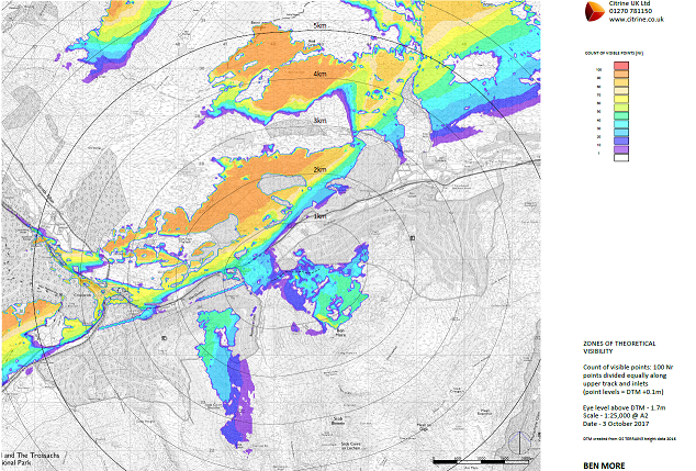
The Zones of Theoretical Visibility Assessment submitted three months later in December 2017 provides further evidence to show that the LLTNPA’s Screening Opinion was wrong:
The LLTNPA was set up in no small part to protect the landscape. In its rush to approve as many hydro schemes as possible, at the behest of the Scottish Government, it has failed to give proper consideration to its duty to conserve the landscape.
The proposals for two new hill roads
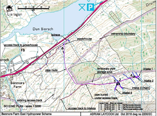
The layout of the proposed scheme does not appear to have changed since the original application. The biggest change appears to be that the concrete for the intakes will now be helicoptered in. Two new permanent roads, however, are still proposed, one connecting the powerhouse to the Benmore Farm track and the other traversing the north flank of Ben More.
While LLTNPA’s EIA scoping opinion claimed the new roads would be 2 metres wide, the new “Access Track Report” fails to specify the width and suggests that the roads are likely to be considerably broader:
Intake track
Access is required to transport plant and machinery to the intake sites during construction and should be suitable for 13 Tonne tracked excavators (as concrete can be transported to the intakes by helicopter).
The same document Intake indicates that 14 tonne excavators are 2.5m wide. This would likely require a road at least 3.5 – 4m wide as tracked vehicles need more space than wheeled vehicles. What is clear is that this road will not then be properly narrowed when construction is complete but instead the verges will be grassed over:
“Partially reinstating the track post construction to reduce the visual impact of the track. In addition to placing turves along the downhill side of the track to narrow the running surface a thin layer of soil is to be applied to the remaining running surface to encourage the growth of vegetation along it.
This is preferable to full restoration as there are safety concerns for ATV’s because of the gradient of the slopes and potential for damage to vegetation due to a lack of alternative routes.”
Note how “full restoration” is not being proposed.
Neither is the road’s landscape impact properly evaluated:
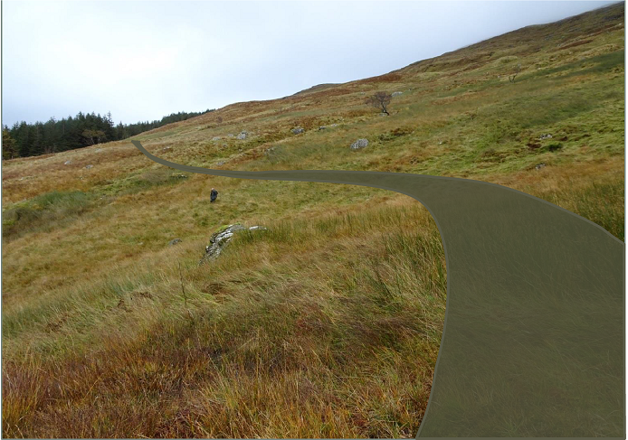
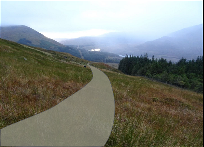
While this and the other photomontages in the application suggests that the new roads will be considerably wider than 2m, in other respects they are misleading. The roads are depicted as a flat plane matching the angle of the slope which is very different to what is actually being proposed:
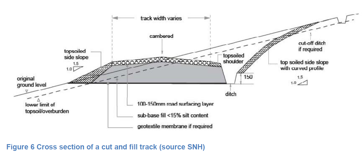
The slope here is steep and, while the road follows a “shelf”, as the document states this is sufficiently sloping to present a high risk to ATVs. Hence the cambered cut and fill.
The document also makes no mention of the LLTNPA’s own good practice guidance which states:
“Avoid steep gradients where possible to minimise the need for cut and fill operations and to avoid erosion.”
While its difficult to ascertain from the documents exactly what is being proposed, it does appear that the upper track will be created by a 8m wide section cut for a kilometre across the northern slopes of Ben More.
The Planning documents contain a number of illustrations of the upper road from the A85 (the lower track is mostly hidden behind a band of trees not shown on the map above). While the photos show the upper road is mainly screened by trees at present, this probably won’t be for long. The Application is silent about Forest Enterprise Scotland’s review of its local Forest Management Plan which is likely to see the conifers here replaced by slower growing broadleaved trees.
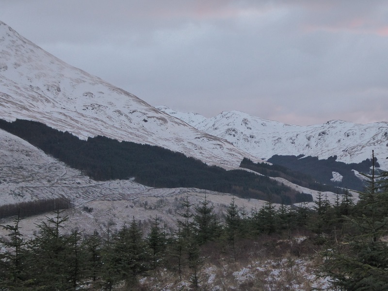
Once the trees are removed the new road across the hill and intakes would be far more visible from below.
While many walkers take the farm road up Ben More, at present looking down the A85 is screened by trees.
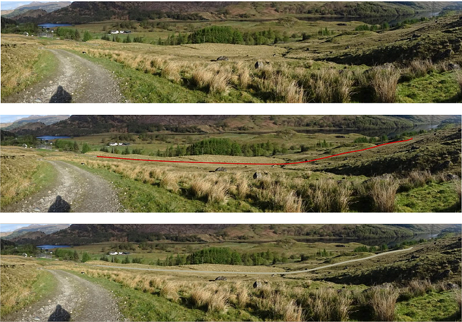
If the proposal goes ahead there will be another road, this time in full view.
The justification for the lower road appears to be that Ben More farm does not own the forestry below the powerhouse (out of sight to the right of the photo) and any route up through the forestry would be very steep. The second problem could be avoided if the powerhouse was located down by the main road as in the other two hydro schemes on either side of the Ben More. That, however, would require the farm and Forest Enterprise Scotland to co-operate and work in partnership. Just why hasn’t the LLTNPA insisted on this? Wasn’t 18 months enough to sort this out?
The justification for constructing and retaining the upper road is also not clear. The pipeline is due to run straight up the hill from the powerhouse to where it would join the upper road. I can find not a single document on the portal which explains how the pipeline will be constructed, a major omission and reason enough to object to this hydro scheme. It may be that because of the small size of the pipe (315mm) no road is required, but that begs the question that if excavators can work without any track/road on the steep section, why not also on the section that traverses the hill?
The “Access Track report” fails to explain why its justification for a new road applies in some places but not others:
Given the rough and often steep terrain it will be difficult to safely transfer materials and equipment to either the powerhouse or intake sites without first constructing a suitable access track. Not constructing a track would risk considerable damage to vegetation as sites may only be accessible using tracked excavators.
The Developer also states in a separate document, Intake Structures and Tracks, that the intakes will be constructed with a 3.5 tonne excavator and their preferred option is to bring in the concrete for the intakes by helicopter. That begs the question, why not bring in all the material this way?
The case for retaining the new road to the intakes is even weaker:
When operational intake weirs will require monitoring and periodic maintenance to ensure they are operating effectively and access will be required in a variety of weather conditions particularly if unplanned maintenance is needed. Vehicular access would therefore be required post-construction however this could be restricted to ATV’s therefore the track to be narrowed to reduce its visibility.
The intakes are very small and could be easily cleaned out by hand. There is no reason why people should not walk in to do this and be paid for the extra time it takes to do so. There are now several schemes outwith the National Park where this happens – its being proposed for the Allt Mheuran Scheme in Glen Etive – and there is no reason why the LLTNPA should not insist on this. Indeed it would accord with the LLTNPA’s own Good Practice Guidance which it has ignored for far too long:
It is expected that any new access tracks required for the construction will be fully restored unless there is overwhelming reason why they should be retained for the operational phase of the development.
What needs to happen
This hydro scheme is tiny yet, for a small amount of electricity, Benmore Farm is proposing two scars across the north face of Ben More, one of Scotland’s finest hills. This is extremely unfortunate and contrasts with the previous scheme they constructed on the Ben More burn, which is one of the better hydros in the National Park and has arguably had less impact than any of the other hydro schemes in Glen Falloch and Glen Dochart.
The LLTNPA has allowed hydro tracks to multiply across Glen Falloch and Glen Dochart and their cumulative detriment to the landscape is significant. This has to stop. If Benmore Farm cannot fully restore any damage caused during construction, including temporary tracks, and requires permanent roads, then the LLTNPA should just refuse this scheme. The small amount of electricity and other benefits does not justify the damage.
Indeed the focus of the LLTNPA should now be on how to restore all the damage to the landscape in Glen Falloch and Glen Dochart which has been caused by the proliferation of hydro and forest tracks.
If you are concerned about this application please comment or object by Friday 11th January. You can do so on the Planning Portal (see here) by clicking on the comments tab and then making a comment. If you are objecting make sure you tick the box to say so.
