On 24th June the Cairngorms National Park Authority (CNPA) launched an “informal” consultation on its initial proposals to amend the core path plan it agreed ten years ago, in 2015 (see here). The consultation, which closes on 31st August, consists (see here) of an interactive map, showing existing core paths with proposed additions and removals, and a list of the proposed changes to the core path network.
Unfortunately the list of proposed changes does not tally with what is shown on the interactive map.. This is best illustrated by the proposals for changes in the core path network, which under the Land Reform (Scotland) Act 2003 includes water, along the River Spey. For example, the list includes proposals to add core paths to the River Spey at Grantown and Cromdale because of their “high recreational value”:
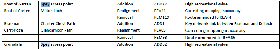
I can find neither of these proposals on the map, so its not clear where they go or whether they are designed to address long-standing problems that canoeists have had in accessing the river.
Conversely while the map shows an additional core path, labelled ADD9 and ADD10, along the Spey upstream of Kingussie (which has been poorly drawn with some of it going over dry land) only ADD10, upstream of Newtonmore is on the list. ADD 10 states this is a “mapping omission from the 2015 update” so, presumably, ADD 9 which lies between it and the existing “core” waterway below Kingussie must be too.
In fact no less than 28 of the proposed core path amendments which are on the list are to correct previous mapping inaccuracies. That speaks volumes about the quality of the current core path plan approved by Scottish Ministers. Another path, at the Uath Lochains south of Insh (Ref REM 106), is proposed for removal because “path doesn’t exist on ground”. A major flaw in the current system for designating core paths is that it does not allow access authorities to correct such mapping inaccuracies, as a result of which the public have been fed inaccurate information for the last ten years. That undermines the very purpose of core path plans.
While a number of activists contributing to the Aviemore and Spey Valley (sic) Community Issues Forum have been campaigning for the Scottish Outdoor Access Code to be reviewed and campfires banned – they have also submitted a petition to the Scottish Parliament to ban disposable barbecues (see here) – by far the biggest issues with access rights in Scotland is that path networks continue to be unfit for purpose, there is no will to create new ones and what paths there are are not maintained.
Access rights and core paths in the Cairngorms National Park
Almost all the recreational and land-management interests involved in the negotiations which led to the Land Reform (Scotland) Act 2003 agreed that once the traditional freedom to roam had been secured as a right, the key task in Scotland would be to create a network of paths to support access rights. While Scotland had access rights, England and Wales had far more paths in the form of rights of way. With a legal right to roam, there was no need to create new Rights of Way in Scotland but there was a need for more paths (and core routes along waterways), hence Clause 17 of the Act:
“It is the duty of the local authority, not later than 3 years after the coming into force of this section, to draw up a plan for a system of paths (“core paths”) sufficient for the purpose of giving the public reasonable access throughout their area”. (My emphases).
The CNPA quote this in their consultation but nowhere do they analyse whether the existing network of core paths is SUFFICIENT or REASONABLE for the purposes of enabling access throughout the National Park. While stating that “there are over 650 miles of core paths in the Cairngorms National Park”, the National Park covers 1,748 sq miles (4,528-square-kilometres). This means means there is approximately one mile of core path for every 3 square miles of land. Compare this to the Lake District which covers 912 square miles and has almost 2000 miles of rights of way (see here) or two miles of rights of way per square mile.
The key components of the path network in the Lake District are effectively six times greater than the Cairngorms and, while these figures don’t cover all the other types of paths and track in either National Park, I suspect once these are taken into account the differences would be even greater. One might have thought this would be of concern to the CNPA but not a peep.
If you exclude the paths in Strathspey and the River Spey on the CNPA’s core paths map from consideration, large parts of the National Park are core path free zones:
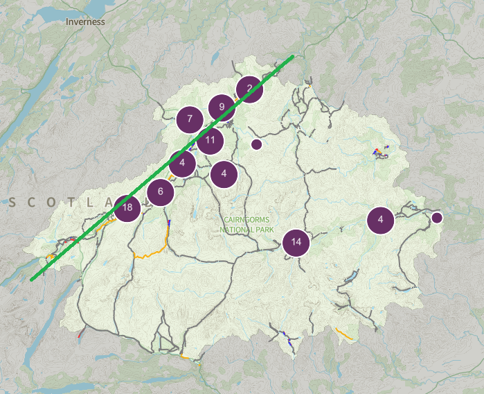
While you might expect there to be more core paths in Strathspey because the population is higher there and it attracts far more visitors, that does not explain the almost complete absence of paths into the Monadhliath on the eastern boundary of the National Park. In fact the best explanation for the distribution of core paths in the Cairngorms is whether the land is managed is managed for sporting purposes and more specifically intensively managed for grouse.
The absence of core paths on the King Charles main estate at Balmoral, despite the extensive track network there speaks volumes:
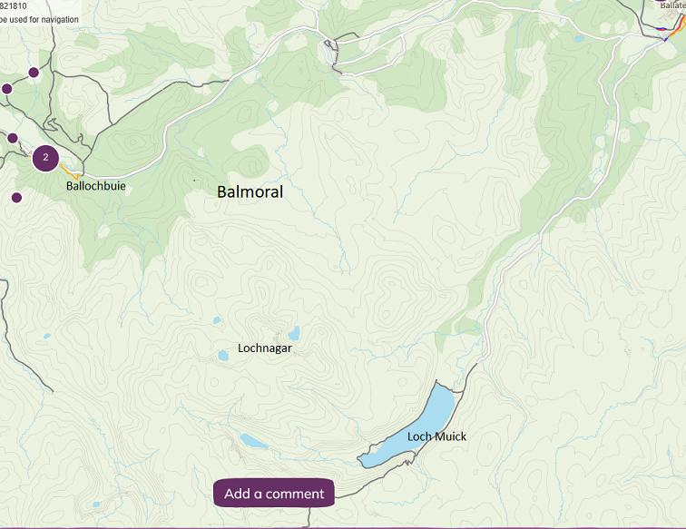
It appears that powerful landowners, starting with King Charles, are determining where core paths should go and most don’t want any on their land. In the case of King Charles, this means no core path through the Ballochbuie Caledonian Pine Forest, no core path up Lochnagar and no core paths anywhere near Balmoral or the Gelder Burn. The King’s only concession is the path around Loch Muick where people are charged to park their cars.
The exception to this proves the rule. There are just two significant additions being proposed to the core path network which lie on large private estates and BOTH are on land owned by the Danish Billionaire Anders Povlsen and managed through Wild Land Ltd:
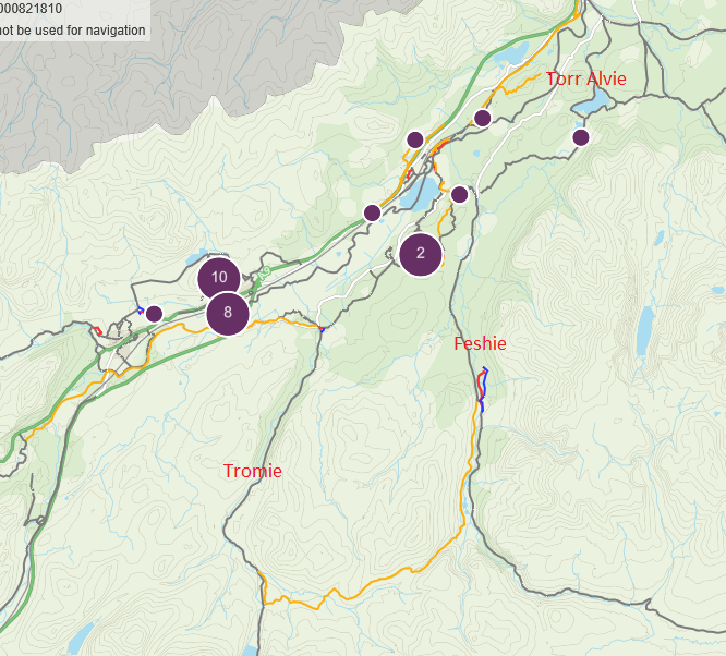
The first connects Glen Feshie and Glen Tromie and the second is the beautiful walk through juniper up Torr Alvie, one of the finest viewpoints in Strathspey. While I have no intention of defending the wealth of billionaires, clearly Povlsenand Wild Land Ltd – which has led ecological restoration in the National Park through reducing deer numbers to less than 2 per km – also has a very different philosophy to other landowners when it comes to access and is supportive of the aspirations behind the Land Reform (Scotland) Act 2003.
It is worth noting that while Strathspey may appear relatively well provided with core paths, once you take out National Cycle Route 7, which runs along the A9, and the River Spey the density of core paths per square mile drops considerably.
Proposals driven by a lack of resource
The CNPA’s consultation fails to mention that access authorities have extensive powers to create and maintain new core paths under the Land Reform (Scotland) Act 2003.
- Clause 19, “Power to maintain core paths” empowers access authorities to “do anything which they consider appropriate for the purposes of—(a) maintaining a core path; (b) keeping a core path free from obstruction or encroachment; (c) providing the public with directions to, or with an indication of the extent of, a core path”;
- Clause 21 gives access authorities the power to enter into agreements with landowners to create new paths;
- Clause 22 gives access authorities “Compulsory powers to delineate paths in land in respect of which access rights exercisable.
As a result there is no opportunity for the public to comment on HOW the CNPA is using these powers at present, whether they should be used to create completely new paths or what paths need maintaining.
The March meeting of the CNPA’s Local Access Forum recorded (see here) that:
“24 access obstruction cases have been reported this year (to date) [ie 2024/25], with 20 now closed and the remaining 4 open. This represents a slight decrease on the previous year where there were 33 cases, compared to 28 cases in 2022/23.”
Sixteen of the cases in the last year involved barriers to access, including locked gates, and the LAF meeting was explicitly asked about how the CNPA should address the multiple problems at Deshar Woods near Boat of Garten. No-one suggested the obvious solution, that the CNPA use its path making and maintenance powers to open up the woods to the public.
While part of the explanation for this failure to promote and enhance access rights can be explained by the power of landowners, lack of resources also plays a significant role. That can be seen in the proposals for the core paths plan. Two sections of core path have been swept away by landslips since the 2015 plan and, rather than replacing them, the CNPA is proposing to remove these paths completely.
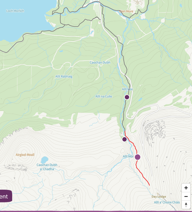
The first is the section of core path above the Utsi Bridge by the Allt Mor which connects the Cairngorm Mountain with Glen More (Consultation Reference REM 71). Years ago, before any ski road was built, my father used to walk and ski up Cairn Gorm from Loch Morlich. Now the CNPA is proposing to remove the main pedestrian link. That directly contravenes one of the management principles agreed by the CNPA board in 2016 when they approved the Cairngorm and Glenmore Strategy which was that:
“Improvements to transport and access infrastructure will increase public transport and non-motorised access to the area from Aviemore and beyond; and walking and cycling within the area”.
Clearly failing to replace this damaged section of core path is not going to help increase non-motorised access to Cairn Gorm. This is yet another National Park plan/strategy which was never worth the paper it was written on. The current core path may be irreparable but this is an issue that would not be difficult to fix. The old road, now overgrown, runs down by the Allt Mor and could be used as a replacement – but this would require the CNPA or HIE to invest some money.
It will be interesting to see if Highlands and Islands Enterprise/Cairngorm Mountain Scotland Ltd object to the removal of this path from the network. There are no core paths at Cairn Gorm, not even the track up the Ptarmigan or the popular paths leading into the northern corries.
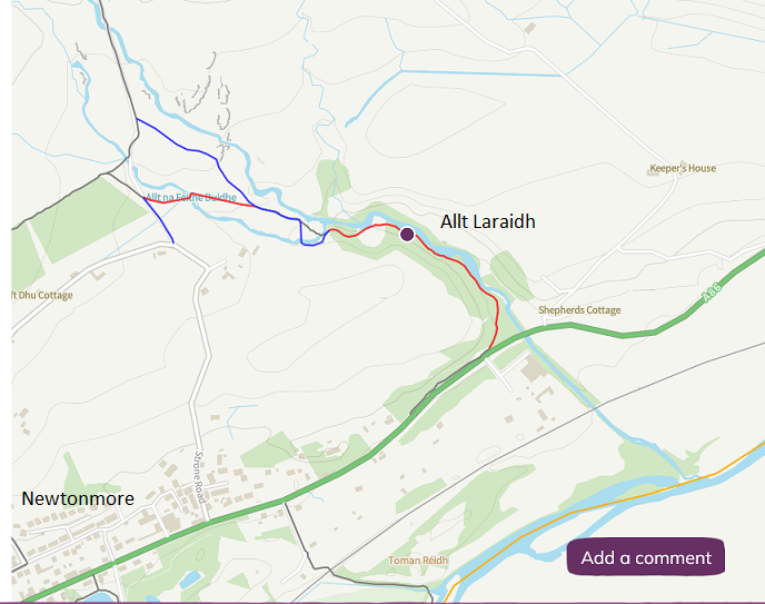
The second section of core path which the CNPA is proposing to remove (Reference REM 110) forms part of the Wildcat trail, a circular route around the village of Newtonmore, which the CNPA’s own website (see here) describes as “an iconic path”. Removing this section – it is still walkable along eroded banks and climbing over fallen trees – without an alternative effectively means the end of the Wildcat trail as originally conceived.
In truth, the CNPA has never supported the Wildcat trail, a fantastic community initiative designed to deliver the vision for access which led to access rights. The CNPA, however, have completely lost the plot in proposing some new sections of core path a little further upstream (blue on map above) which lead nowhere. The whole point of core path plans is that they should provide a system or network of core paths not, as Bob Reid would put it, chopped up spaghetti.
Where core paths are damaged by natural events like landslips, the response of the CNPA should either be to repair them – I will be submitting an FOI to the Access Team to see whether they have costed this – or if this really isn’t possible find alternatives. As well as these two cases they should be looking at the section of core path in the upper reaches of Glen Feshie, which has also been badly damaged by a landslips, but about which nothing is said in the consultation.
A plan which fails to take account of the routes valued by people
While the rationale for some of the proposed additions to the core paths plan is given as “High Recreational Value” (see table above), in my view the proposals take little to no account of the recreational experience. For example, the consultation does not ask people to say what routes they value.
While the public can propose additions, they can only describe their ideas – being forced to register each one separately – rather than add them to the map. These are then presented to the public on a list (see here), which gives the reference number of the path without saying where it is. Top of the list this morning, for example, is a comment from someone on LBS71 which states “the path is in poor condition and could do with some maintenance”. Why should the public then have to research through the consultation to try and find out where this is? The whole consultation has been designed as a bureaucratic exercise which makes it very hard for people to participate or say what matters to them.
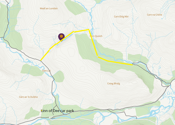
I have submitted a proposal for a new core path in response to the consultation to illustrate the difficulties of doing so. I have suggested a route on the Mar Lodge estate managed by the National Trust for Scotland which is notable for having as few core paths as the large sporting estates. I could not draw the line on the online map (as I have done on the screenshot above but was asked to give the start point, end point etc This discourages suggestions and makes it very hard for others to understand what is being suggested and indicate whether they support it or not (there is a thumbs up facility you can use to show whether you agree with any of the proposals).
A good demonstration of how the CNPA is disregarding of the quality of the recreational experience is their proposal to replace the core path along banks of the Spey downstream of Kincraig by the extension of the Speyside Way:
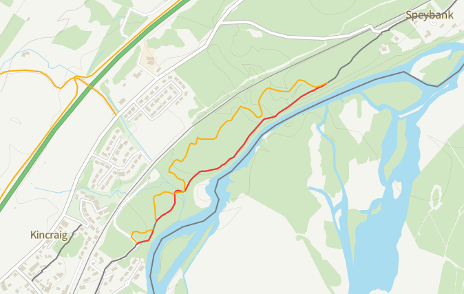
The existing core paths offers great views over the river in comparison to which the Speyside Way is an inferior route which, as you can see from the map, is also less direct and significantly longer. There is no justification for this removal and the CNPA could have just added the Speyside Way to the existing route.
The underlying problem here is the CNPA has no philosophy or strategy behind what role the core path network should play in the Cairngorms, except that it won’t do anything contrary to the wishes of landowners or costs it monety. As a consequence it continues to take a minimal approach to the legislative requirement to provide SUFFICIENT paths to provide REASONABLE access THROUGHOUT the area.
This has resulted in a core paths plan and amendments which are rationally indefensible. For example:
- Why add a core path up Torr Alvie and NOT Creag Dubh at Newtonmore or the many other popular smaller hills in the National Park? (There are a couple of other smaller hills with core paths to the top including Creag Choinnich by Braemar and Creag Bheag above Kingussie).
- Why are some long distance routes across the Cairngorms included in the plan (the Gaick, the Lairig Ghru and Lairig Laoigh) but not the Minigaig or Jocks Road across the Mount?
- Why aren’t other historic routes like Wade’s Road, where it passes through the Ralia and Phoines estates, or the Burma Road which crosses into the Monadhliath behind Aviemore and is now extremely popular with cyclists, not being added to the network? (Ironically, Wade’s roads formed part of the first attempt to create a core path network in Scotland – the CNPA is only 250 years behind.
- Why, of all the popular Munros and Corbetts in the National Park, do only Meall a Bhuachaille, in Glen More, and Morrone, south of Braemar, have core paths to the summit (and in those two cases offer different routes up and down)? What is the justification for this?
An incoherent approach to core paths and access rights
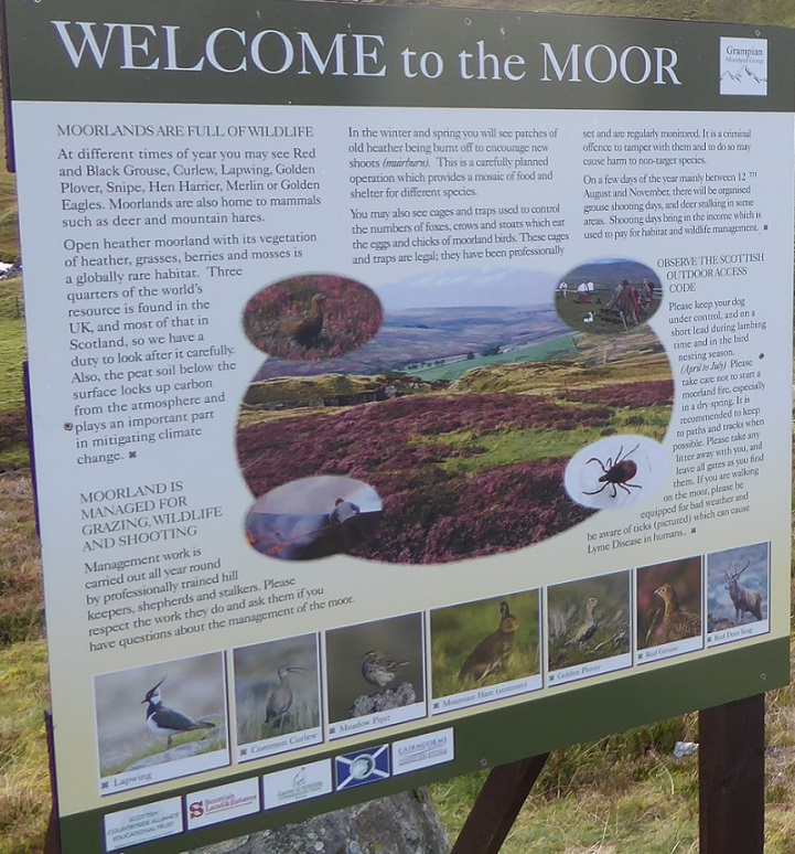
For years the CNPA has endorsed the message “keep to the path” or “it is recommended to keep to the path”, claiming this was compatible with access rights, while failing to provide sufficient core paths to enable the public to enjoy those access rights. While the newer Moorland Group signs don’t have the CNPA’s logo on them, the CNPA has still been actively promoting its “keep to the path” messaging, as in this sign at Dorbach I saw in January:
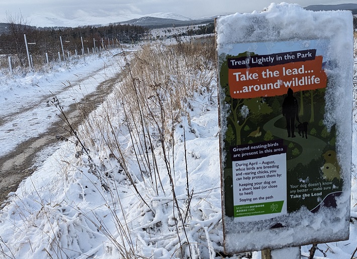
The intention behind Scotland’s access legislation was to secure people the right to enjoy the countryside off-path, while creating a core path network to facilitate this. Providing a completely inadequate core path network and then urging people to keep to this is completely the opposite of what was intended.
It was a small step in the right direction, therefore, when in July the CNPA issued revised guidance on access signage (see here) which makes no mention of “keeping to the path” but instead states “the wording and tone of the signs also must not deter or intimidate people from exercising their access rights”. Clearly any general message advising or requesting people to keep to the path – unless there is an exceptional reason for doing so – would contravene that.
The second major incoherence on the part of the CNPA is that it has been very happy to support significant investment of public and charitable monies in path work on private land within the National Park, most notably through the Mountains and the People Project but before that the Deeside Access Trust, without then insisting these paths should become part of the core path network. The “tourist” footpath up Lochnagar, owned by King Charles, is a case in point. It should be a condition of any public or lottery funding that these paths then become part of the core path network and that the CNPA, as the access authority, then has a duty to protect these investments by ensuring maintenance agreements are in place.
The Scottish Government, core paths and the CNPA
Ultimately responsibility for the failure of the CNPA (and the LLTNPA before them, see here for example) to create a network of paths which could evenly remotely be compared to that in the Lake District lies with the Scottish Government. Successive Scottish Governments have dampened down the original ambitions of the Land Reform Act and instead of pressing access authorities to expand the core paths network over time, have them to stagnate while retaining the bureaucratic processes created by the legislation. The result is lots of time and effort is wasted in periodic reviews of core path plans which change very little. That is why we need a review, led by those representing outdoor recreational interests, into how core paths have worked.
Unfortunately, neither staff nor board members of our National Parks have been brave enough to challenge the current state of affairs or to demand that path networks in Scotland be properly funded. The introduction of the Visitor Levy provides an obvious opportunity to change this. Bed night taxes are used by many local communities on the continent to fund path work and maintenance – but so far neither National Park has made the case for this and neither employs footpath workers.
The pernicious influence of the Scottish Government on the core path network is apparent in the CNPA’s core path plan consultation. Many readers will be aware of the dispute over the railway crossing at the station in Dalwhinnie, which Network Rail has tried to block. To their credit, the CNPA have suggested in the consultation that a section of track on the far side of the level crossing be added to their core path network so it joins up with the core path network in Highland. They have not, however, been able to add the level crossing itself to the core path network because they have received a Direction from Scottish Ministers that any existing level crossings which form part of core path networks must be removed. As a result the CNPA is also proposing that the level crossing at Dalnaspidal, on the south side of the Drumochter pass, should be REMOVED from the existing core path network.
I have made a Freedom of Information request for a copy of the Ministerial Direction and any accompanying correspondence but I cannot see any justification for this. Core paths don’t give people exercising access rights precedence over other land-uses: for example there are core paths along roads which cross junctions, so there is no reason they should not also cross railways.
Three years ago the then Minister Jenny Gilruth was reported as telling Kate Forbes, the local MSP who has supported the campaign to keep the Dalwhinnie crossing open, that Scottish Ministers had no influence over this matter (see here). One of her successors now appears to have issued a Ministerial Direction. Ms Gilruth was either misinformed by her civil servants or lying. What a mess!
What needs to happen
I hope this post encourages more people to respond to the CNPA’s initial consultation on their core paths plan before it closes on 31st August. While a formal consultation on the CNPA’s proposals is still to come, it will be much harder to gate major changes to the plan at that stage. If 50 people each made one suggestion for a new core path – as I have done for the Clais Fhearnaig – it might at least put some pressure on the CNPA to start acting like a National Park.
The underlying issues that need to be tackled, however, are about how core paths could be made to work and in particular how to tackle the lack of money to maintain paths and the power of landowners.
While the visitor levy could help, ultimately in my view a percentage of the transport budget needs to be allocated not just to active travel, much of which goes on cycling, but also to routes used for outdoor recreation.
As for landowners, the voluntary sector and new “green” owners could start setting an example by proposing much more comprehensive networks of core paths on their own land and then put pressure on traditional landowners, like King Charles (who has been patron to many voluntary sector organisations who own land) to follow suit.

The Scottish Law Commission, in its report of level crossings laid before the Scottish Parliament in September 2013, concluded that “local authorities can designate a core path over any land” and that includes railway lines (para 5.57). This is the latest legal opinion on core paths and railway lines in Scotland. The ministerial directive referred to above can therefore by ignored by the CNPA and all other local authorities who should continue to designate core paths over railway lines, where appropriate. If Network Rail does not accept this they will need to take legal action against the Scottish Government, if necessary as far as the Supreme Court, where they are almost certain to fail.
Signs telling people to stick to paths seem to be becoming common. Most recently I spoted some at Dalrigh near Tyndrum, professionally done, and more credible than most I have seen, saying you must stay on paths and must not wild camp, and threatening folk with CCTV, because of there being an SSSI. This is, of course, total BS, as SSSIs are constraints on land owners and land management, not on the statutory right of access, and the Order for this one even specifically refers to right of access in keeping with the Outdoor Access Code as being fine (https://sitelink.nature.scot/site/377). Also, the first sign there is a very long way away from the SSSI, which pretty much just encompasses the pine woodland there. They annoy me greatly, but I suspect the best way to fight this is simply to educate people on what their access rights (and responsibilities) are, so they are comfortable ignoring them.
If you have any photos of the signs you could send that would be great Nickkempe@parkswatchscotland.co.uk – the signs should be reported to the access team at the LLTNPA accessteam