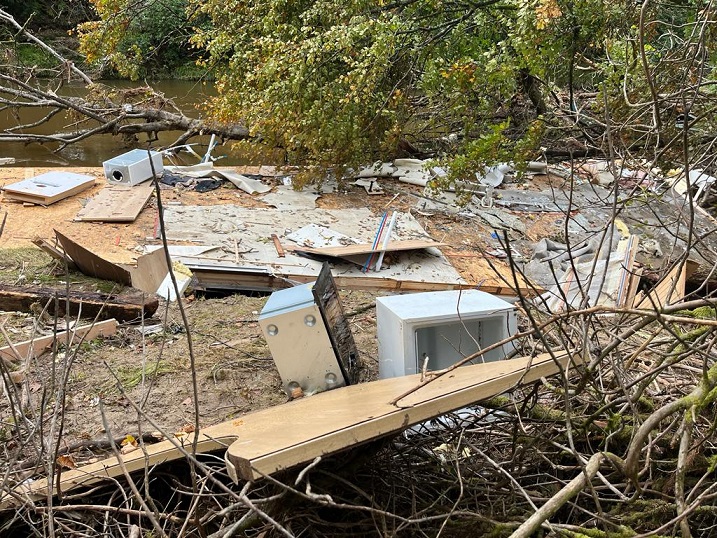
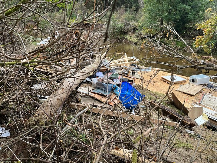
Since writing about the consequences of the extreme rainfall which fell in Cowal (see here) and Glen Kinglas (see here) on 7th October, I have been sent some further photos which provides an opportunity to add to some of the arguments I made in those posts. While I saw the extent of the extensive flooding when I was in Cowal on the 9th October, I had only heard about, not seen, the consequences for human infrastructure.
The rainfall over the weekend of 6th/7th October made it the wettest weekend in Scotland since records began in 1891. The Met Office has produced an excellent report (see here) which, however, still leaves one guessing about the amount of rain that fell in Cowal. Although the Met office have a rainfall guage at Benmore Gardens it is not automated, the records are not online and are not shown in the report.
The map in the report showing estimated rainfall across Scotland, shows most of Cowal receiving 100-150mm of rain with just a few small areas receiving 150-200mm, less than the 200mm reported by locals. Interestingly, however, the Met estimates that to the north west over 200mm of rain may have fallen which would appear to fit with what was experienced around Loch Eck. Both SEPA and the Met Office need more rain guages!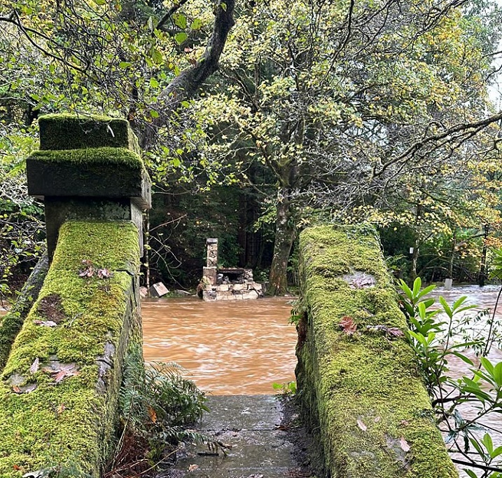
The listed pedestrian bridge at Benmore Gardens was swept away. Photo credit Parkswatch reader.The rainfall that was brought to Scotland by Storm Babet was far more restricted in extent -my thanks to a reader who alerted me to the excellent Met Office report (see here). However, it caused record rainfall in Angus (which had just two weeks earlier received the sixth highest rainfall ever recorded for the area). Like the report for 6th/7th October, however, it is not detailed enough to explain variations of rainfall within river catchments such as the 80mm SEPA recorded at Gella Bridge in upper Glen Clova. The important point here is that if 150mm of rain had fallen at Gella bridge, as appears to have happened just to the south, the water levels in the River South Esk at Brechin, which exceeded all previous records, would have been far far higher.
Its an emergency and the Met reports are really clear about this: extreme rain events are increasing in both frequency and severity. The Reports also help explain why this is happening – in the case of the extreme rainfall 6th/7th October it was caused by unseasonally warm air from the south meeting much colder air from the north.
What these extreme rain events show, however, is that besides occurring more frequently and with greater intensity, they could happen anywhere. While getting civil engineering right is extremely important – in particular we need to ensure that built developments are not at risk and don’t make flooding worse – creating effective flood defences across Scotland is not possible in the short-term (the Dutch have taken several centuries) if at all. Changing land-use, so that the rate of water run-off into our river systems is slowed down, is likely to achieve more and for a fraction of the cost.
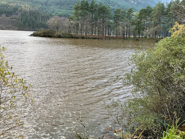
Eleven days after I had visited Lock Eck, its waters were still brown, filled with sediment. There are two public interest questions here, where did the soil come from and why, and, what impact will all this sediment have on the (rare) wildlife in Loch Eck?
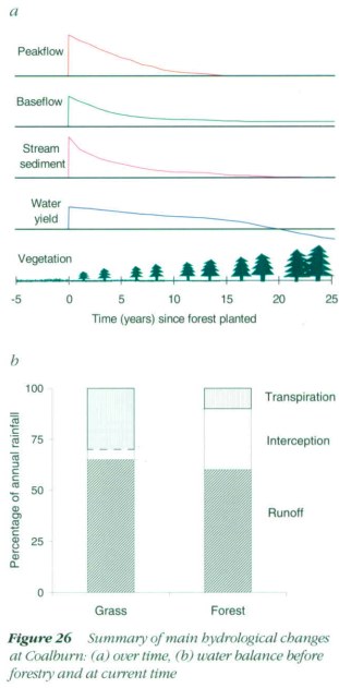
Most of the area around Loch Eck is covered in forest and forests have been shown to reduce sediment run-off. My thanks to Ron Greer who pointed me to this graphic from the Coal burn study which included looking at the impact of forestry on sediment in streams (see here):
How then could so much sediment end up in a loch surrounded by trees? One possible explanation is that the flood plain along the River Cur was seriously eroded by the deluge and washed sediment into the north end of Loch Eck and this then spread 10km down the loch. Another possible explanation is that industrial forestry practices have helped undermine the stability of the steep slopes around Loch Eck which would normally have been helped by being planted by trees.
There is a very interesting map on slope stability in Forest and Land Scotland’s Lock Eck Management Plan (see here) which shows landslips:
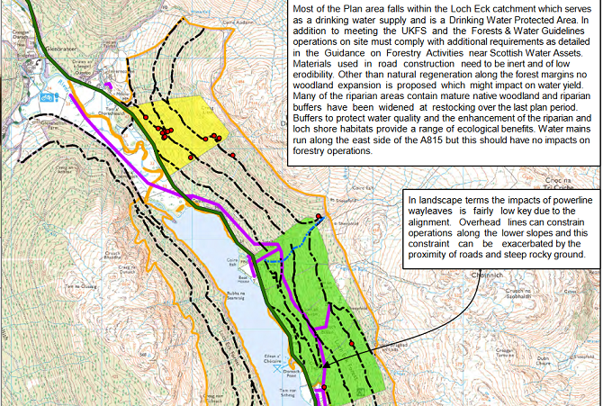
The fact that most of the recorded landslips are by forest roads could be because they are easier to spot but it could also be because those roads were helping to cause the landslips. Add to that the clear-felling that has been taking place around the loch, which involves heavy machinery churning up the soils, and it appears quite possible that FLS’ management of the land may be responsible for much of the sediment in Loch Eck.
I will return and have a more detailed look at the land when I get the chance.
The likely impact of the silt on the ecoystems in Loch Eck, which is designated a Site of Special Scientific Interest, is complicated. Silt for example affects the level of oxygen in the water, its temperature and also what predators can see (see here). It may favour some species and harm others. Back to Ron Greer, a retired freshwater scientist, for the following comments:
“Siltation can affect salmonid egg and fry survival, but powan spawn later in the year, so as long as this doesn’t persist for months then there’s hope that this event will not be too serious in the long term.”
“The charr will either spawn on the shore or in one of the main inflow streams and my main worry would be general long term climatic warming affecting eggs survival ( there is mortality above 5 Celsius). If the charr here are autumn spawners ( most Scottish charr do) then there would be some concern about siltation impacting on egg survival in addition”.
“On a more hopeful note, both these species have survived dramatic environmental events over millennia, including landslips in the fluvio-glacial processes at the end of the last glaciation event and periods of warmer and colder climate since then.”
The jury is still sitting then but who is collecting the information, studying what has happened in the loch and on the land round about, so that informed decisions can be made about forestry practices around the loch? Not, as far as I am aware, the Loch Lomond and Trossachs National Park Authority, which claims it wants to put tackling the climate and nature emergencies at the heart of all it does.
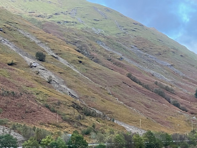
Over in Glen Kinglas, just outside the National Park boundary, there have been significantly more landslips than the eight BEAR reported as reaching the road. This reinforces the case for creating a comprehensive data base of landslips in Scotland in order to properly assess risks to infrastructure. Knowing about the landslips that don’t hit the road is as important as knowing about those that do.
Meantime the fact the owner of the Strone Estate, Tom Turnbull, who is also chair of the Association of Deer Management Groups, is still grazing (or allowing someone else to graze) sheep on these slopes should to my mind be treated as criminal, an offense against the public interest. The fact that the Scottish Government is subsidising him to do this through greening payments – as I explained in my last post – appears even more criminal.
This is a repeat of what happened up the road at the Rest and Be Thankful. Throughout the 10 years or so it took for the Scottish Government to buy the land and plant trees, Glen Croe farm was allowed to continue to grazing sheep on the slopes of Beinn Luibhean. When is the Scottish Government going to stop this stupidity and start putting the public interest before that of individual landowners?
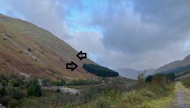
Nick Halls kindly went to check that the plantation I had referred to in the Glen Kinglas post and which had been granted a felling license by Scottish Forestry was still there. I had commented how stupid it was that Scottish Forestry would even consider granting felling licenses on landslip prone slopes. Nick’s photo proves the point. It shows two landslips above the trees.
That evidence should be sufficient to prompt Scottish Forestry to undertake an immediate review of all felling licenses for trees on steep slopes vulnerable to landslips.
Meantime Lorna Slater, the Minister responsible for Scotland’s National Parks, could do worse than ask them to outline, on two sides of A4, what needs to be done to reduce the risks of flooding and landslips caused by extreme rain events..

All steep slopes above public roads should be planted with trees, without deer fencing, if soil, climatic, landuse and geological information indicates there is a risk of landslips and existing forest cover is inadequate. If the landowners refuse to cooperate the Scottish Government should use its compulsory purchase powers, or suspend the landowner’s access to agriculture and forestry grants until compliance with the public need is achieved.
hi nick ,i know that particular area very well (River Eachaig)we used to have a static caravan there for 15yrs
it is very prone to flooding and the ground is very sandy(used to watch sand martins making ther nests and fledging their young)stratheck has expaned 10 fold since the dixon family sold it,some of the static/cabins are far too close
to the river,if you knew the area you would keep those well away(i rememer mary murton saying its one storm from disappearing)that was 40 yrs ago,ive also stayed with the(tia)at stonefield for my 50th biblical weather
the river massan flooded really bad she lost 15ft of land in some areas,the one thing i have noticed is logging on both sites,
but saying this i used to earn a bit of pocket money planting for the EFG (unfortunetly) i remember when there were no pine trees there,but the both places were only made for very few people
i fear what we are seeing is human expansion into a already fragile eco system and also the ferocity of logging going on there the waters just pouring off the hills ,trees absorb a lot of water and when thats gone, the water as we all now know will find a way(and that usually means populated places)as many of us will know some places look to say (to be polite)shocking,it is a total manmade disaster and it will continue more places will be affected,i dont know the answer
but i do understand the question