While governments across the world fail to implement or row back on actions to reduce our carbon emissions and respond to climate change, CO2 fuelled hot air wreaks increasing havoc. The same heat that is causing more hurricanes in the Caribbean at the end of each summer often drives the tail end of those storms over the west of Scotland dumping huge quantities of water. The main difference between 2023 and the last few years is that the most extreme rain event – I have learned to avoid planning trips away in September – arrived later. That late arrival may be connected to the fact that July, August and September have been the hottest months on earth since human records began. Over the last few days it has been far warmer outside my house than in. In England it has been 25C.
This post argues that what happened on Saturday and Sunday in Cowal provides yet more proof that government, inside National Parks and out, is fiddling while Rome burns and drowns. A significant part of the problem is that government as a whole uses the lack of information and data about what is happening to avoid tackling the real issues and keep the public in the dark.
How much rain fell in Cowal? Does government care?
By chance I had arranged to go over to Cowal on Monday to look at forestry there. Parts of Cowal were added to the Loch Lomond and Trossachs National Park as a result of intensive lobbying by local residents twenty years ago. Since then neither Park officials nor the Board have paid it much attention and Forest and Land Scotland have been given free rein to manage the land as they please.
While geographically to the LLTNPA HQ at Balloch, its quite a journey from there by road and in any case the A83 is often closed (I arrived at Hunter’s Quay at 10am to find long queues of cars waiting for the ferry – not the fault of the operator, Western Ferries).
Cowal is a very wet place but locals told me they had never seen such extensive flooding or experienced so much rain as fell on Saturday. Some were claiming that 200mm or 8ins of rain had fallen in the one day.
Unfortunately it is hard to verify that claim as the Scottish Environmental Protection Agency has not a single rainfall guage or river level monitoring station in the whole of the Cowal peninsular.
That is not SEPA’s fault. As the Ferret recently showed, the Scottish Government has slashed the funding of the agency responsible for protecting people and the natural environment over the last decade (see here). SEPA responds where it can or where it is expedient to do so – interestingly there are no less than two rainfall guages in close proximity at the Rest and Be Thankful!
If we are to prepare for and respond to extreme rain events we need comprehensive data on rainfall and river levels and the impact this is having across Scotland.
Looking at SEPA’s data for Luss, which has both a rainfall guage and a river level guage one can get an idea of the severity of what happened.
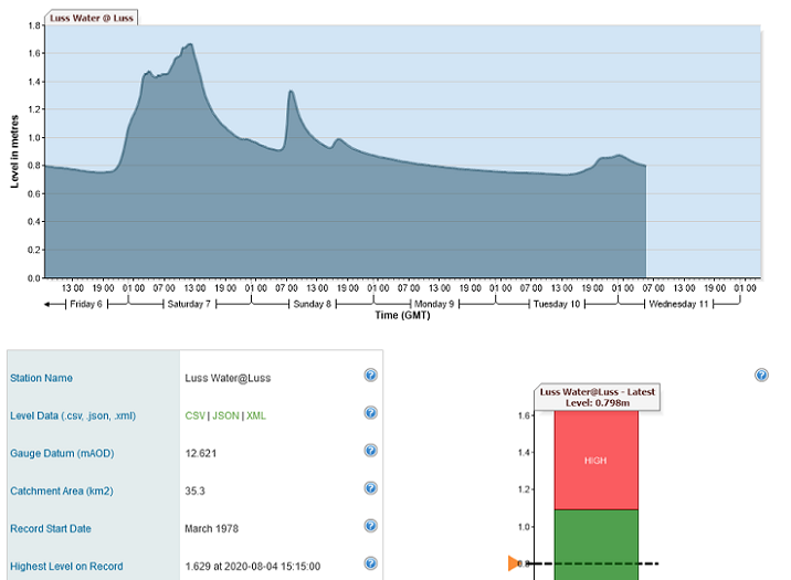 The water level at Luss on Saturday appears around 1.6m, touching the highest level since records began in 1978. Unfortunately, SEPA’s rainfall data (see here for Luss) only give daily rainfall the last couple of months, with historic information provided in the form of monthly records. The spreadsheet I have download for the current period (see here) shows 67.2mm of rain fell on Saturday and 45.4 on Sunday. You cannot tell therefore if Saturday’s rainfall at Luss was a record. Moreover, even if it was, before inferring that this record rainfall was responsible for record water levels one would need to take account of other land-use factors (there is, for example, a hydro scheme on the Luss Water which affects its flow and water levels).
One also needs to take account of saturation of the land. The total rainfall recorded so far for Luss in September and October combined is 384mm. That is significantly less than the 454mm recorded in December 2015 for example.
Within this context, however, if local people are right and 200mm of rain fell in Cowal that is almost twice what fell in Luss and therefore what you see in the photos is hardly surprising.
The public interest questions this raises in terms of Scotland’s response to the climate emergency is who is analysing the data we do have, identifying the gaps and looking at the implications? And why are bodies like the LLTNPA so incapable of speaking out about the need for far better information? Without data, for example, how can anyone say whether what happened on the River Elchaig was one of those 1:200 year flood events which informs planning decisions?
The impact of the extreme rain event
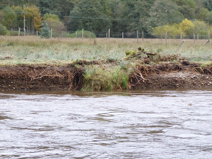
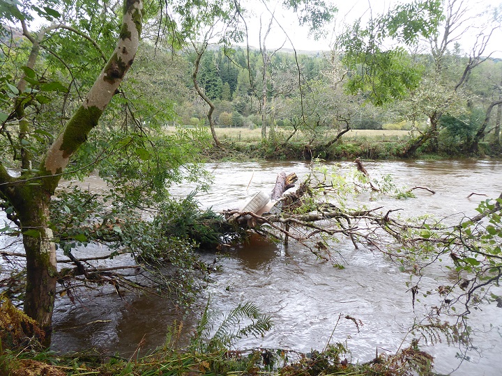
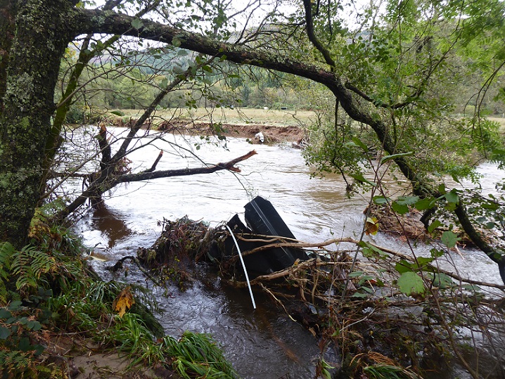
From the evidence I have seen and heard, however, the flooding in Cowal appears worse than anything that had been experienced for fifty years: trees, riverbanks and human infrastructure around and below Loch Eck were swept away by the water.
There was a big clear up underway with roads being cleared of rubble and items retrieved from the loch and river. The flood claimed at least one caravan from the park below Loch Eck, an example of planning failure and a warning of what might happen if the LLTNPA allows Flamingo Land to build chalets and develop other visitor infrastructure on the flood plain in Balloch (see here).
When the River Elchaig burst its banks the flood plain was covered with water to an extent that locals had not witnessed before. Two days later the water had disappeared but in that time the the flood plain had served its purpose. Without it the major road bridge on the A815 downstream might not have survived.
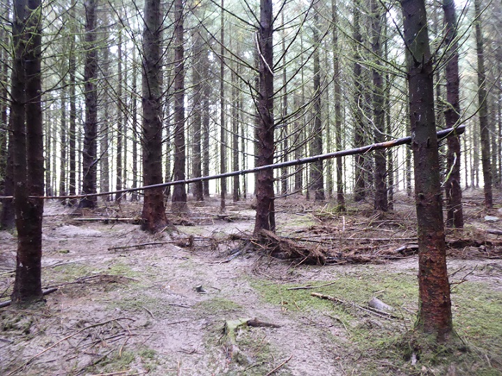
And while the flood had re-arranged the brash in this conifer plantation, the trees will have helped hold back the force of the water.
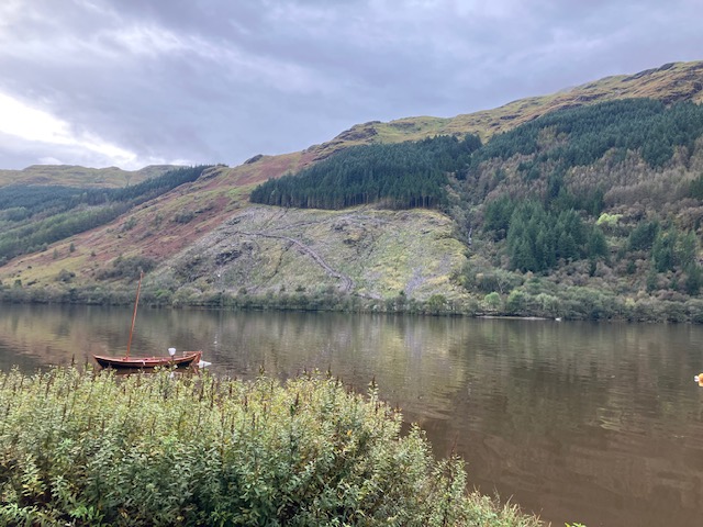
The success of the flood plain, however, does not mean there is no need to be concerned. People I spoke to had never seen Loch Eck brown like this, filled with soil.
Loch Eck is a Site of Special Scientific Interest (see here):
“for its outstanding fish community which is believed to be one of the most natural remaining in Britain. Loch Eck is one of only two Scottish localities for the powan, a race of the nationally rare whitefish Coregonus lavaretus and is also one of two British sites, and the only Scottish site, where Arctic charr Salvelinus alpinus and powan co-exist. The Loch Eck charr itself is of interest as a dwarf form and as one of the most distinctive races in Britain. In addition, the presence of the migratory Atlantic salmon Salmo salar and sea trout Salmo trutta trutta make Loch Eck the only water body in Britain where these four species occur together.”
So how will all this soil in the water have affected the fish in one of Scotland’s most important sites for nature? Has there been a mass extinction event?
The need to monitor soil erosion and landslips
The world’s soils are also eroding at an alarming rate (see here) and while SEPA monitors some soil erosion this is mainly for cultivated agricultural land in the east of Scotland (see here). The soils around Lock Eck may no longer be important for agriculture but they are still crucial for storing carbon and growing trees. So will Forest and Land Scotland (FLS), which manages most of the land around Loch Eck, get together with NatureScot and SEPA and review the extent to which their industrial forest practices has has been turning the water brown and affecting wildlife?
Along with better information on rainfall and flooding, the Scottish Government should be asking/equipping SEPA and our other public agencies to collect data from across Scotland on soil erosion .
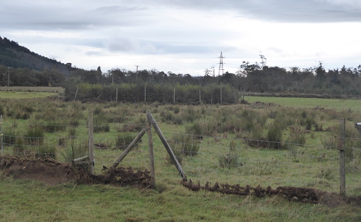
That data on soil erosion should, as I have argued previously, include data on landslips. Government has shown almost no interest in that up till now despite what has happened at the Rest and Be Thankful. Perhaps with road closures becoming a more serious problem – within Cowal landslips last weekend closed the B836 in Glen Lean (where a bridge has also been partially swept away) and the B828 in Glen Mhor (see here) – government at all levels might also start to show an interest in understanding WHY landslips appear to be occurring with increasing frequency?
While the British Geological Survey does record landslips, there is no requirement on public agencies to report these and no system for relating records of landslips to land-use. The Board of the Loch Lomond and Trossachs National Park Authority has never once considered what they could do about landslips despite the near disaster on Loch Katrine (see here).
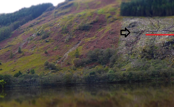
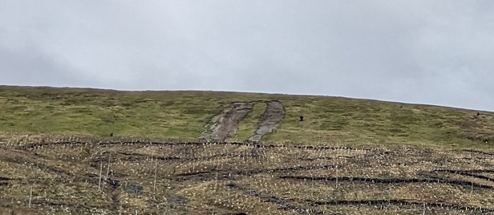
On Monday I spotted five new landslips within a few miles and my estimate is there may have been 25-30 across the whole of Cowal last weekend. I now expect them to be triggered by extreme events (photos from readers would be welcome!). While their cause is complex, which is why need to collect data on when and where they occur and link that to more detailed research, there is no question that land-management plays an important role.
The starting point for the landslip on the right in the photo above, for example, is where FLS have cut a road into the hillside which they have then lined with trees – an incredibly wasteful process – to provide a base for machinery to extract the remaining timber.
Whether soil from this FLS induced landslip reached the loch and was then washed out to sea is unclear but NatureScot should investigate. Their site management statement for the SSSI states:
“The potential exists for some run-off from agriculture and some levels of siltation and possible acidification linked to forestry practices.”
Spot on! So how did NatureScot ever allow this track to be constructed?
Even from a blinkered industrial forestry perspective this is an incredibly stupid and unsustainable way to manage land. FLS need to preserve soils if it is to continue to grow trees for timber in future. Having trashed this public asset, perhaps FLS has already decided to sell it off?
What needs to happen?
First we need to end the silence and the default position of all our public agencies which is to try and shift responsibility for tackling the consequences of global heating onto the public.
I cannot find any news releases about what happened at the weekend from the LLTNPA (last one was about the Oak Tree Inn targetting net zero by 2040 on 29th September – worthy but hardly a game changer), SEPA or NatureScot. Apart from the public roads network, the only public authority to say anything was FLS who advised drivers to avoid using their forest roads as short cuts because of the damage caused by the rainfall (see here). (FLS’ reference in their news release to waterlogged soils “giving way” is a tacit admission that forestry tracks do pollute water courses).
Without news releases, media coverage of extreme events is limited to the impact on the transport network. Our public authorities are complicit in keeping the public ignorant about what is really happening. Both the public and the wildlife in Lock Eck deserves far more.
Second, the Scottish Government needs to resource our public agencies properly, so they can work together in the public interest, and commit to making changes to the regulatory and rural subsidy framework to change land-use where needed.
The sensible way to do this in respect of mitigating the impact of extreme rain events would to reinvigorate River Catchment (now called basin) Management Plans. Unfortunately, SEPA’s own River Basin Management Plan for Scotland 2021-27 (see here) is almost silent on the question of land use and flood prevention. In my view it is not fit for purpose and needs to be radically revised.
A good start, as I have argued here, would be for Scottish Ministers to ask and finance SEPA to create a network of guages for monitoring rainfall and river levels across every river catchment, extend their monitoring of soil erosion across Scotland and as part of that set up a system for monitoring landslips. That would provide an information base for the various partners in each river catchment to plan what needs to be done to mitigate the impact of extreme rain events.
Meantime, the Green MSP Lorna Slater, as the Minister responsible for National Parks and Nature Scot could ask both authorities to report on what happened at Lock Eck and what they could do to reduce the likelihood of it being repeated.

Carbon dioxide – ask yourself what you really, really know bout this essential gas?
97% of the 0.04% of it naturally emitted every year is from entirely natural sources, such as volcanoes. Of the 3% remainder which is man-made and derives from eg making concrete, etc , forming 0,004% (four one thousandths of one percent) of our atmosphere, the gas is equally readily absorbed by our planet and plant life, etc. This has been proven beyond all doubt; the Chinese industries more than doubled the output of man made carbon dioxide between 2002 and 2003, yet the increase in total carbon dioxide remained at the same constant rate of increase as it has been since before the Industrial Revolution.
Take a moment to educate yourself, see Professor Murray Salby’s seminal lecture in London on Atmospheric Carbon of 18 June, 2016, don’t be among the ‘bloodletters’ he describes so aptly in his closing remarks.
https://youtu.be/3q-M_uYkpT0?si=5G1zNCeIJiE7Lbem
Need some more? See William Happer (one of the original climate scientists) IPA lecture of September 2023 on The crusade against carbon dioxide (search YT, you’ll find it I’m sure – IF you look for it.
https://www.desmog.com/2013/07/12/murry-salby-sacked-australian-university-banned-national-science-foundation/
No-one is saying CO2 isn’t essential to life but tiny changes in the the concentrations in the atmosphere have a massive impact on the heat of the world, the greenhouse effect. You are wrong to claim these concentrations haven’t changed. They have increased to 421 parts per million (ppm) or about 0.04% (as of May 2022) as you say but from pre-industrial levels of 280 ppm or about 0.025%. That is a huge increase given how CO2 “works” and the primary cause is the burning of fossil fuels. While concrete is a lesser but significant contributor of emissions your claims about 97% of carbon emissions coming from volcanoes is bunkum . I only publish comments like yours to show just how much misinformation is being circulated? My thanks to the reader who posted the information about Murray Salby.
To judge from the highly critical response above, the fact that carbon dioixide is absorbed by plant life, yet swathes of virgin rain forest across Malaysia, Indonesia and the greater Amazon basin have been cleared for various “agricultural” reasons, has become too incovenient to be noted by some people. There are also teh wild fires across tundra and Taiga all around the northern hemisphere. Huge areas of the global land surface have been covered over with concrete since the 1950’s Not only releasing CO2 but further decimating plant life. ( A worthwhile set of trial IR spectrum satellite images highlighting absorbed light, and retained heat release by night, appeared over this past weekend). So many facets to this most inconvenient truth, too many early converts to climate change denial now choose to ignore?
I know you love to knock the Scottish Government, but in reality the cut to SEPA funding in real terms over that period was 26%. In England the UK Government has cut funding to its equivalent Environment Agency by 56% in real terms over the same period – more than twice as big. As described here:; https://www.independent.co.uk/climate-change/news/water-pollution-sewage-environment-agency-funding-b2154848.html – whilst any real terms cut at this time of environmental uncertainty is bad, as usual the Scottish Government has actually managed to protect us from the worst excesses of the UK Government that we would otherwise be suffering. Why criticise that with your unbalanced post?
Hi Andrew, thanks for this. First this is primarily a blog about Scotland’s National Parks (except for access where I do stray further afield) and while I do take a wider perspective (global heating is a problem of world capitalism) my primary focus is Scotland. Second, in respect to your specific points the cuts to the Environmental Agency in England have been even greater (and by the way what is happening to Natural England has been even worse than what has been done to NatureScot) but to use that to defend what the Scottish Government is doing/has failed to do seems to me completely indefensible. The point is that a Scottish Government that professes to want to address the climate and nature emergencies is cutting the two main state agencies that could DO something about those issues. To say that is not unbalanced, its the truth. Incidentally SEPA is also the agency responsible for protecting the environment when it comes to energy generation (including Grangemouth) so in terms of the supposed transition away from fossil fuels and the impacts of new technologies like carbon capture and hydrogen, one might have thought that both SEPA and EPA down in England would have a greater role than ever before.
Cuts to budgets of various UK Government departments and national agencies recently,once related back to the period just after the financial crash of 2008 – only- are really not very informative. The presumption of “eternal growth” achieved through feeding borrowed money (from a defecit GDP position into the UK service sector) had to be rebalanced. It is notable how many recent pay claims by public sector workers in 2023 ( rail NHS, teachers et al) do relate back only so far as that short halcyon, and inept period of Governmental largess. The consequence, as we all became well aware, shown by the infamous note said to have been left on the chief secretary’s desk at the Treasury..”there is no money left”. The struggle to regain a correct balance between national service essentials and the frivolous misuse of public funds – including open ended commitments to PFI contracts at huge % mark-up, has continued ever since. (The past decade the ‘tabloid’s label “austerity” redirects opinion of those who- either deliberately or through ignorance- fail to see the reasons this happened. It would be more useful if more people were shown how in so many ways between 2004-2008 pay settlements and unregulated gov spending had never been so huge?
This comment came from Nick Halls by email:
Luss, Loch Lomond & much of the Trossachs are in a ‘rain shadow’, as the prevailing wind is south westerly, and even with a returning polar maritime airmass this is the wind direction that brings practically all the heavy precipitation.
A rain shadow is formed by the range of hills from the Holy Loch to the Cononish hills, that drain into the River Tay catchment and Loch Awe
The Beinn Mhor & Beinn Ruadh massive catches most of the rain. Ardentinny is relatively dry at sea level, compared with Strath Echaig.
The area may be among the wettest localities in Scotland. Also, the rainfall above 300 metres is possibly double that at sea level.
Loch Eck & Loch Lomond are virtually at sea level, but the rainfall may be markedly different.
Rainfall measurement at Luss gives very little idea of the rainfall higher up the hills to the west, which drain into Loch Eck, Loch Long & Loch Lomond. Each of which has the largest area of drainage basin on the western side, due to the complex metamorphosed mica schist fold structure of the geomorphology of Cowal. This is all evident from the OS Landranger maps 50 &56
I would hazard a guess that Luss may get less than half the rainfall and volume of runoff experienced in the Glen Massan, Loch Eck and River Chur drainage basin. This is also evident from the maps
That SEPA has no rain gauge and thus no data relating to precipitation in the whole of Cowal is surprising! Rainfall data from Luss can only give a very distorted picture of rain fall further to the west.
Benmore Gardens may keep meteorological records, for botanical purposes. The local people who witnessed the depth of water on the flood plain quoted the figure of 8 inches of rain, and a depth of flood water on the flood plain in the order of 2 metres, water borne debris was above head height in places.
Loch Eck, which is a source of drinking water and is usually clear, is still brown with fine silt on Sunday, 15th of October.
It is possible that the ecological damage resulting from the flooding is far greater than it may appear, but the physical damage is bad enough, with all road access to the area blocked by landslips.
I think it is imperative that national agencies collect and share much more data from the area if its status as a part of a National Park is to have any meaning in relation to conservation, restoration and combating climate change.