The headwaters of the River South Esk, which flooded Brechin last week with such destructive effect, lie in Glen Doll in the Cairngorms National Park. The River South Esk then flows down Glen Clova, where it is joined by the River Prosen, before leaving the Cairngorms massif and turning in an easterly direction through Brechin to Montrose. This post argues that the management of grouse moors, like grazing and landslips (see here), is key to understanding what went wrong and what we might do about it.
Muirburn and water run-off in Angus
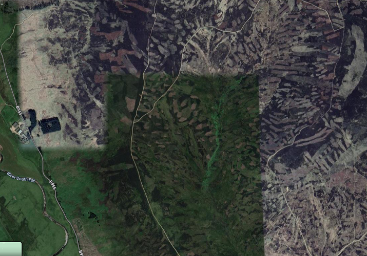
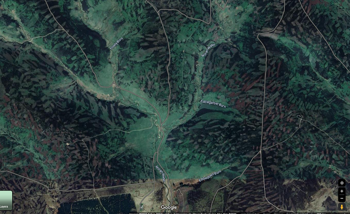
The south east fringes of the Cairngorms north of Brechin include some of the most intensively managed grouse moors in Scotland or the wider UK. In many parts of the catchment of the River South Esk managing the land for driven grouse shooting is the dominant land-use.
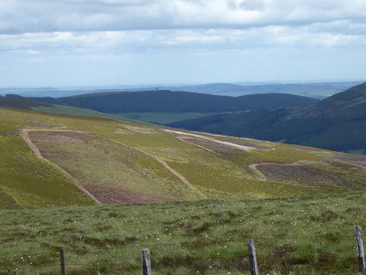
The muirburn, besides destroying peat which helps absorb rainfall, also removes surface vegetation, including plant litter, which helps slow the flow of water downhill. The rate of water run-off is almost certainly sped up further where the burned strips are oriented downhill, rather than across slopes.
The impact of muirburn on water run-off and flooding has been very little researched, perhaps because it is against the interests of landowners and shooting interests to do so. The Werrity Review (see here), the “independent” review of grouse moor management in Scotland which reported almost four years ago, noted there had been few studies of hydrology on grouse moors but decided not to add the the draining of grouse moors to its remit (page 11).
Meantime, a google search will reveal that organisations representing sporting interests have issued a stream of claims that intensive grouse moor management actually helps to reduce flood risk. The British Association for Shooting and Conservation, for example, in their evidence (see here) to the 2020 UK Parliament Inquiry into the floods that have affected northern England claimed:
“The rough and absorbent surface of an effectively managed moor reduces the risk of flooding by slowing the flow of water when compared to pasture and to roads and other urban surfaces”
That rough surface and absorbent surface is exactly what muirburn destroys:
Muirburn in fact does exactly the opposite of “natural flood management”, the restoration of woodland and peat bogs to reduce the amount of water flowing into watercourses. The conclusion is obvious. If the Scottish Government and its agencies really want to reduce the amount of destructive flooding that affects places like Brechin they need to tackle grouse moor management. Unfortunately Scotland’s whole system of flood prevention and management appears designed to conceal this fact.
How much rainfall caused the unprecedented flooding in Brechin?
The problem starts with the very patchy data on rainfall that is collected across Scotland (see here) which means that often we have very little idea how much rain has fallen in a river catchment. This problem is accentuated by the fact that extreme rain events are often very local in extent and the size of river catchments on the east of Scotland (the River Esk is relatively small but nevertheless c564 square kilometres).

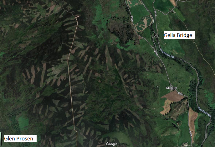
SEPA has just one rainfall guage for the whole of the River South Esk catchment above the Montrose Basin. It is located in the lower part of Glen Clova at Gella Bridge (top diamond flat above)
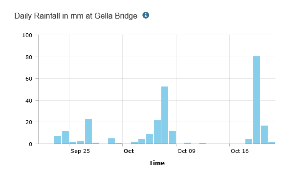
The 80mm which fell on 19th October and just under 100mm in 36 hours compares to the 160mm which fell in many parts of Argyll two weeks earlier. Unfortunately, the records for daily rainfall on the SEPA only go back a month so its not possible to tell whether the 80mm was near previous records or not. However, if the rain guage is correct, claims in the media that Storm Babet brought a month of rain in a day should be taken with a large glass of salt water. The lack of further rain guages makes it impossible to say how much rain might have fallen elsewhere in the catchment except for the Montrose basin, where the River South Esk flows out to the sea and 60mm fell in 24 hours..
Over to the east at Invermark, on the headwaters of the River North Esk where a woman drowned, a SEPA rain guage recorded much higher levels of rain: 150mm of rain on the Saturday and about 165mm over the weekend. To the north in Glen Muick, on the Balmoral Estate, 100mm was recorded on the Saturday and c130mm over the weekend. With the rain coming from the east, it is likely the amount that fell in the northern part of Glen Clova was more like Glen Muick than Glen Mark.
It seems almost certain, however, that significantly less rain fell in the upper parts of Glen Clova than has fallen in other parts of Scotland recently. It was also far less than continues to fall in France: a few days after my post on the impact of Storm Alex on the Mercantour National Park in 2020 (see here) “seulement” another 200mm of rain (that is 33% more than was recorded as falling in Glen Esk) fell in the valleys around St Martin de Vesubie, causing further flood damage there (see here).
The important public interest question is what would have happened to the River South Esk if say 150-200mm rain had fallen in upper Glen Clova compared to the 80-100mm that appears to have fallen last weekend?
Not all the water levels on the River South Esk exceeded previous records
SEPA operate more river level guages than rainfall guages. There are four on the South River Esk (map above). Those at Brechin and Tannadice were inundated and stopped functioning but not before the one at Tannadice registered water 0.5m above the previous record. There is general agreement that the level of the water in Brechin was unprecedented.
By contrast the river level guage upstream at Gella Bridge showed water levels 0.5m BELOW the record set in December 2015:

The guage on the River Prosen, which enters the South River Esk a little downstream, however did show that water levels had breached previous records – but not by that much:

This data strongly suggests that MORE of the water that was responsible for the the record floods levels in Brechin entered the River South Esk downstream from the upper part of Glen Clova. This could have been because the most extreme rainfall fell on the hills at the edge of the Cairngorms but might have also resulted from differences in land-use or both.
Understanding this would be quite complex even if we had better data on rainfall. Grouse moor management is generally more intense on the lower hills on the southern edge of the Cairngorms but water run-off from agricultural land could also have helped cause the record flood levels in Brechin
These observations do not mean that the amount of water flowing into the South River Esk above the Gella Bridge during Storm Babet and the reasons for this are unimportant: if there had been less water run-off in the Cairngorms National Park the water levels and damage downstream at Brechin would clearly have been less.
The need for SEPA to install more rain guages as a matter of urgency to help provide answers to these questions and inform decision-making should be obvious.
Flood risk management and the River South Esk
Twenty years ago there was a push towards river catchment planning in Scotland driven by European legislation. One of the five purposes of the EU’s Water Framework Directive of 2000 was to mitigate the effects of floods and droughts. It was followed by the EU Directive on the Assessment and Management of Flood Risks in 2007. In 2009 the Scottish Parliament passed the Flood Risk Management (Scotland) Act which created a duty for the Scottish Environmental Protection Agency and Local Authorities to produce plans to prevent and manage flood risks.
That legislative framework has created a plethora of policies, strategies and plans, so many that is hard to see the wood for trees, a problem made worse by many now being out of date (something not helped by the cyber attack which crashed SEPA’s information systems). Maintaining this system consumes the resources of our public authorities and the energies of those working for them but has also failed to address the factor which, after rainfall, most impacts on flooding, land-use.
Instead of looking at the uplands, where most of the rain falls most of the time, and working out how to slow its flow down from hill to river, the focus has been on areas at risk of being flooded by rivers overflowing their banks. Hence SEPA’s flood maps and assessments of Potentially Vulnerable Areas. The one for Brechin was produced back in 2016 (see here) for the Tay Estuary and Montrose Basin Flood Risk Management Plan (TEMBFRMP) 2016-22 (see here).
A word search shows that in the 423 page TEMBFRMP there is not a single mention of “grouse”, “moor”, “muirburn”, “deer” or “grazing”. These omissions are particularly striking because there are no less than 531 uses of the term “natural flood management” within the report.
In September 2007 the Scottish Government had set up a Nature Flood Management Group “to help them develop a new policy for managing floods in a natural way” and the term has been given plenty of lip service ever since. While the actions on Natural Flood Management in the TEMBFRMP were particularly vague they did mention “upland reforestation”.
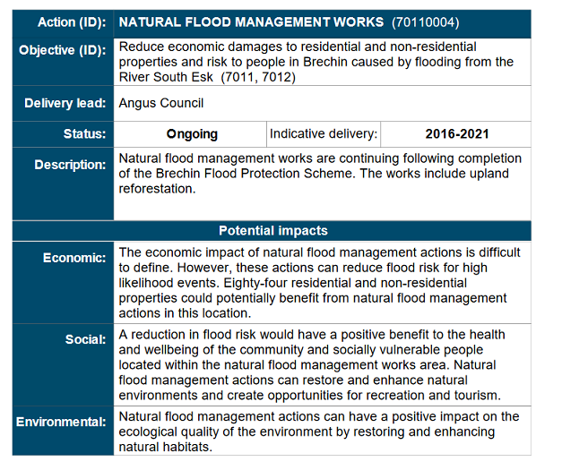
Any meaningful upland reforestation is of course impossible so long as muirburn is allowed to continue so just how this was to be achieved is unclear. The omission permeates the pages and pages of documents produced since 2007: in SEPA’s handbook on natural flood management, for example, published in 2015 (see here) there is also not a single reference to muirburn.
The Interim Report on the TEMBFRMP published in May 2019 shows just how limited the approach to natural flood management had been:
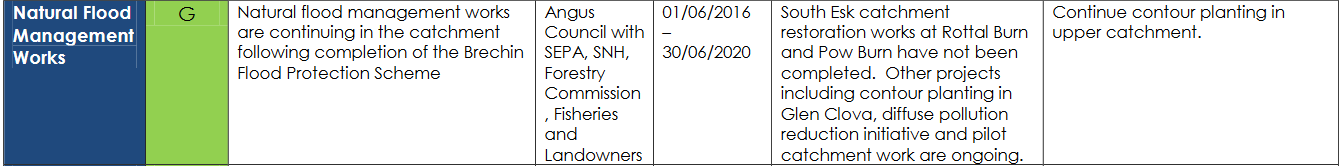
Instead of woodland regeneration, “contour planting”, which it was hoped would stem the flow of water down the sides of Glen Clova noto the River South Esk. How the “rewilding” of a couple of its tributaries, designed to make the water travel further before it joined the main river, would make much difference to flood levels is unclear: once the water is in the river system, particularly when its in flood, its generally too late except where there are empty flood plains to take the water.
The priority for natural flood management should be further up the hill in the areas that receive the highest rainfall. The main actions that would make a difference are peatland restoration – the area arguably receiving most government attention and largesse, albeit not in a strategic way – a reduction in grazing levels and an end to muirburn.
Meaningful progress in any of these areas is, however, impossible as long as the power of landowners to make decisions about how to manage their land goes unchallenged and while the Scottish Government relies on voluntary measures and co-operation to achieve its objectives on a whole range of issues relating to land-use, from deer control to flood prevention. The Flood Risk Management Act created no new powers to control how land was used in the uplands and the predictable result is almost all action from our public authorities has focussed on the lower ground. That doesn’t excuse their public silence on the destructive impacts of grouse moor management.
What has happened at Brechin shows that the voluntary approach to the uplands and focus on the lowlands has completely and utterly failed. It is just seven years since the Review of the TEMBFRMP in 2016 classified recent flood protection works at Brechin aas “green” (i.e being on target):
“The existing Brechin Flood Prevention Scheme 2015/16 provides protection from river flooding. The existing scheme is located along River Street, Brechin. The scheme comprises a number of features to reduce flood risk in Brechin. This included the construction of a 1.5km flood defence wall, 1.8m high embankment, and installation of 3 submerged pumping stations, improving the Denburn culvert, upgrading existing surface water drainage, numerous headwall outfall structures and raising 300m of the footway in River Street.”
The River South Esk Catchment Partnership – captured by sporting interests
Voluntary arrangements to manage water above Brechin have been undertaken through the River South Esk Catchment Partnership (see here). This produced its first plan (see here) in 2009, published a review of progress in 2017 (see here) and then consulted on a new plan in 2018 before all went silent (see here).

The catchment plan repeated the focus of the TEMBFRMP. Those flood defences completely failed to hold back the water from Storm Babet even if, as the Justice Secretary Angela Constance pointed out, they did give more time for people to be evacuated from their homes safely (see here). Those local residents would have had even more time and might still be able to insure their homes if water did not flow off the land so quickly in the first place.
Six years ago, in their review of progress, the South River Esk Partnership declared itself a success:
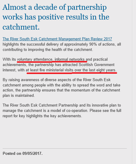
That success appears to have measured by the number of Ministerial visits (and photo opportunities) – so many that the catchment partnership appears to have almost lost count! – rather than any meaningful action on a landscape scale. Did Humza Yousaf not know about those visits when he visited Brechin earlier this week and promised yet more public money for flood defences (see here)? Did he not ask himself what the catchment partnership and all those Ministerial visits had achieved?
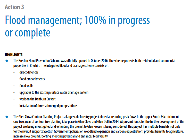
That claim of 100% progress shows just how hollow those actions were.
If you want to understand why so much government attention has been given to small-scale riparian planting schemes as opposed to wider land-use, you need look no further than sporting interests. Sporting landowners are only too happy to accept financial assistance to plant alongside rivers because this could help improve the quality of the fishing (and failing that the new woodland could be used for pheasant shooting). What they don’t want is any change to the way grouse moors are managed.
The Rottal Estate, just outside the Cairngorms National Park boundary, provides a good example of this. Under the South River Esk catchment plan they received public money from SEPA to help re-wild the Rottal Burn (see here) which had been straightened in the 19th Century. A contribution on the Rottal Estate facebook page on 1st October explains the importance of this work for salmon (see here):
Great stuff but meantime the muirburn on the hillsides above the Rottal Burn appears to have continued unabated:
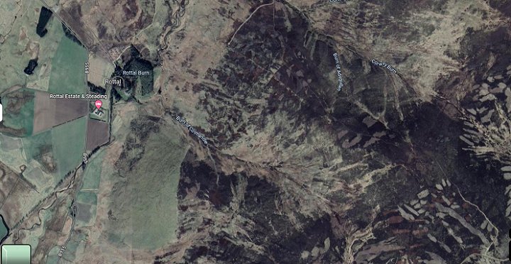
Perhaps that muirburn could help explain why a bridge on the Rottal Estate was swept away by Storm Babet (see here) despite the river being re-engineered? How the roaring river shown in that link fits with the the river levels recorded at Gella Bridge downstream is unclear. Perhaps the Gella Bridge guage was malfunctioning or perhaps the Rottal Estate received the brunt of the rainfall or perhaps more water drained off its hillsides than elsewhere in the upper part of Glen Clova? Someone in government should be asking these questions and trying to ascertain the answers.
If muirburn is less extensive in the part of the River South Esk catchment that lies within the National Park that is because the landowners there are interested in things other than grouse (the upper part of Glen Clova lies is part of the Balmoral Estate and is favoured by King Charles for deer stalking, while Glen Doll is mainly owned by Forest and Land Scotland and subject to intensive forest management). Land-owners have continued to do just as they want in the National Park. Instead of driving the River South Esk Catchment Partnership to take a landscape scale approach to flood prevention the CNPA has allowed itself to become pre-occupied with little “projects” (as illustrated on the map above) which make no difference when it comes to mitigating the impact of climate change.
Scotland needs to new approach to flood prevention
The River South Esk has been causing damage to property in Brechin for a long time. SEPA’s flood risk assessment (see here) shows a house was inundated back in 1774. Those floods, however, have been becoming more frequent and getting worse. It may be that with more extreme rain events predicted we need to staring following the example of the French (see here), who have been demolishing houses deemed too dangerous to live, and start a planned withdrawal from places like Brechin.
Instead of responding to the understandable calls by the National Farmers Union, emergency services and the local community by automatically promising more money to build higher flood defences, clear drains, dredge rivers etc, government should take a brief pause and consider what might happen to Brechin if similar levels of rain fell in the River South Esk catchment as fell two weeks previously in the West. The evidence on cliamte change and extreme weather events suggests that improved flood defences, especially if conducted in isolation, is just not going to work.
However, before considering a planned withdrawal (with full compensation for people forced to more) the Scottish Government and all its agencies should attempt to address the risks by changing land-use; for places like Brechin the immediate priority is to end the intensive management of grouse moors and ban muirburn.
The Scottish Government has been delaying grouse moor reform for years and has now proposed some rather weak measures as part of the Wildlife Management and Muirburn Bill. Having declared a nature and climate emergency, Storm Babet provides yet more evidence of why we need to act quickly. An immediate ban on muirburn and the removal of hill tracks which also increase water run-off, accompanied by a properly resourced research programme to monitor the impacts, would help show which places could be saved by changing the way that land in the uplands is managed.
For the people of Brechin I would hope that includes the place they call home but meantime they and the wider public should be very angry about the grouse moor owners who are allowed to manage their land for private pleasure rather than the public interest.

Many will be aware that for centuries cities down the upper Rhine valley both the Switzerland, Germany and France have suffered from seasonal catasastrophic floods. The Black forest region is well known for huge summer thunderstorms.
Communal efforts by all nations to prevent sudden surges down valleys that feed into the Rhine have served to slow the pace of the water. A glance at google maps -satellite veiw – today does permit an overview of each of the Rhine tributaries. In the Freiburg region….as one example …look closely for the Mohlin , Dreisam and many other tributaries. Zooming in on each map will permit study of the parallel bunds at some distance from each river bank allowing a clear grassed overspill area. Close zoom will reveal regular “weirs” composed of huge boulders , placed at intervals of 25 or 50 mtrs across the main channel.
Near Lorrach on the German side these impediments to rapid flow more closely resemble a man-made staircase up so many narrow gorges. So many lessons for hydrologists to learn, if only our universities ( and Political planners) in Scotland knew to look at how extreme run-off is today managed in some of the largest global river catchments. Rhine Rhone Seine, and in USA, the Tennessee valley, and of course the massive Mississippi. What is necessary is true political imperative. ‘Wringing hands” until the next event achieves nothing.
The person who should carry primary responsibility for the appalling flood damage in Eastern Scotland is King Charles. For decades he has been told, by experts like the late Adam Watson and Dick Balharry, as well as by official environmental bodies, that deer numbers and muirburn needs to be reduced on Balmoral and other estates in the Grampian area. This advice had had little impact. The Report of the Deer Working Group, commissioned by the Scottish Government in 2017 and presented to them in Dec 2019, highlighted Balmoral and its neighbouring landowners as the worst estates in Scotland for excessive numbers of red deer in the Caenlochan area. https://www.gov.scot/publications/management-wild-deer-scotland/. This reflected the failure of 20 years of voluntary control schemes, all because of a lack of cooperation by the estates involved. Those who are now suffering the flood damage that has resulted in part from this lack of action and cooperation might, in the first instance, send the invoices for repairing the damage to the Balmoral estate office. The Royal Family has plenty of money to help all who are impacted by the excessive flood water flowing from the over burnt and overgrazed hills in the ownership of themselves and their neighbours. All that King Charles has to do is to dip into the enormous profits that the royal family is expecting to receive from the licenses granted for offshore windfarm development. These literal “windfall” profits are leading to a 45% increase in the royal family’s grant, courtesy of the UK taxpayer, as it rises from £86 million to to £125 million by 2025: https://www.theguardian.com/uk-news/2023/jul/20/king-charles-to-receive-huge-pay-rise-from-uk-taxpayers. That will be plenty of money to compensate flood victims and pay for the large number of deer stalkers who need to be recruited, as a matter of urgency, on Balmoral and its neighbours. The only additional action that the First Minister then has to do is to ban muirburn throughout Scotland.
Build on historic floodplains, ignoring basic laws of nature and hydrology (still going on all over the land8
Continue to drain farmland and thus increase velocity of water runoff. “. “. “
Plant trees in ploughed or mounded areas, thus increasing runoff. “. “. “
See the pattern of human intervention? The people in positions of decision making in these respects are more liable than anyone when Mother Nature does what she does anyway. But to ascribe this act of nature to Muirburn is just daft, take a walk on the land there and you’ll soon feel the carrying capacity of heather moorland. Better to grind the axe at some more pertinent doorstep.
Are you equating heather moorland with intensively managed grouse moors?
I can only agree with you. There’s been a large increase of drainage in the Glens by ploughing downhill on steep ground whether it’s for potatoes or for all the afforestation going on just now. This is taking place on ground which had hardly been ploughed in the past. Whatever happened to contour ploughing? Have the forestry industry decided to shelve contour ploughing for cost-saving? There are some very strange land management practices going on in the Glens mthese days.
There is a problem that no one ever mentions although Nick has shown examples. Rocks and boulders. Every time there is an increase in the normal rate of flow of any stream or river, more and more materials from every hill and mountain are washed further and further downhill until a point is reached when the force of the water is unable to push them any more. This then raises the water level of the river in its lower reaches. Lighter materials wash down into the sea helping sea levels to rise. As an extreme example about 12 – 15 years ago after a heavy rainfall so much timber was washed down the river Coquet that it piled up against a bridge, similar to what happened at the Utzi Bridge in Coire Cas, the force of water then destroying the bridge. The resulting surge caused the loss of 13 boats moored in the Coquet, some swept out to sea, and areas of the silted river bed that had not been seen for decades were suddenly exposed. The RNLI estimated the speed of the water at over 20Knts. The answer? Instead of dredging rivers and dumping the materials at sea, helping to raise sea levels, they need to be moved back upstream to their former positions, but of course that is a much more expensive option and probably considered to be environmentally unfriendly.
Nothing to do with the 152 mm that fell from the sky?
40mm more in a 24 hrs period that I have recorded.
The Gella recording of Dec 2015 was a snow melt.
They be the facts and context.
River Street House are unfortunately for residents built on flood meadow. Used to be the bleaching greens of old.
As I explained SEPA has a limited number of rain guages and the only one upstream of Brechin showed 80mm. It was the River North Esk that 150mm was recorded by SEPA. If you recorded 150mm it would be very helpful to know whether that was in the River South Esk catchment and approximately where, ie upstream or downstream of Gella Bridge. Very helpful to know that the record levels at Gella Bridge in Dec 2015 were due to snow melt – have you an explanation why the 200 year old Rottal Bridge survived those floods but not the lower levels last weekend? (Was it just age?)
Its bizarre that public money is paid to estate owners to regenerate their blanket bog habitats while they are still allowed to destroy them with fire. Whats the point?
Worth looking at the Met Office report on Storm Babet to draw balanced conclusions on the crucial role of the uplands and the need for genuine catchment-based strategies: https://www.metoffice.gov.uk/binaries/content/assets/metofficegovuk/pdf/weather/learn-about/uk-past-events/interesting/2023/2023_08_storm_babet.pdf
Presumably a SEPA report on the event will also follow also including river flow data.
Thanks Iain, very interesting. Unfortunately there are no Met Weather stations on the River South Esk so that leaves us with the SEPA station at Gella Bridge which showed significantly less rain (80mm) in that part of Glen Clova than elsewhere in Angus. The issue that should raise with politicians is IF 150mm of rain had fallen in the middle part of Clova, as appears to have happened in other parts of Angus, what would that have done to the flooding in Brechin?