This post considers Cairngorm Mountain Scotland Ltd (CMSL)’s second planning application at Cairn Gorm, to create new mountain bike trails in lower Coire Cas. The application (see here for planning papers), as I will explain, is as poorly documented and thought through as the first, which was to create two new roads on the mountain (see here).
Incomplete plans
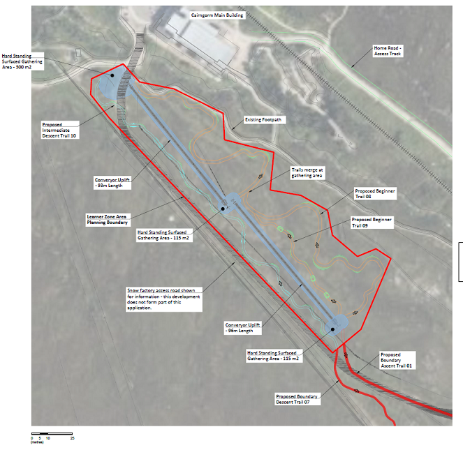
The title of the development, taken from the application form submitted by Ryden LLP, is “Formation of a mountain bike track [singular] and related infrastructure”. The application is in fact for a “family oriented mountain bike park” with several tracks:
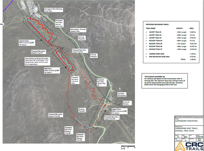
CMSL/Ryden appear to have lifted plans for the tracks, as provided by CRC Trails, and included them in the planning application but have omitted to provide any explanation to go alongside this. This makes it very hard to understand the proposals, for example:
- there is no clear explanation of how the tracks will fit with existing snowsports infrastructure and the implications for this (indeed the primary purpose of the conveyor belt in the “learning zone” would appear to be for snowsports but there is no reference to that in the application);
- there is no explanation of the purpose or concept behind the “Ascent Trail” and why it has been split in Ascent Trail 1, 2 and 3 when it all appears part of the same route;
- there is no key to the colour coding used for the “Descent Trails” although it appears (but see below) to go brown, red, blue in ascending order of difficulty;
- if this interpretation is correct, someone wanting to cycle the “medium difficulty” red trail to the shieling and then back down could then get stranded as the two trails down the mid-zone are both blue and one is labelled as “Advanced Descent 07”;
How the inclusion of an “Advanced Descent Trail” fits with the overall concept which is for a beginners’ mountain bike park, is not explained;
There are also a number of important omissions from the plans:
- there is no indication of how people will access the mountain bike trails from the car park let alone how that will fit with walkers using other footpaths;
- there are no links shown to the funicular or statement about if and how CMSL intend to use it to transport bikes to the mid-station;
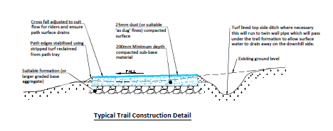
- while three “typical section layouts” are provided, there is no clear explanation of what layout will be used where or how these typical layouts relate to the nature of the ground.
Other important information missing from the application
CMSL has made almost no attempt to assess the likely impact of the development, for example on landscape, the natural environment or transport.
a) There is no landscape impact assessment although Coire Cas is part of the Cairngorms National Scenic Area as well as being in the National Park. That may well explain why response from the Cairngorms National Park Authority landscape adviser to the proposed development is not yet on the planning portal (it was due on the 8th March). I would be very surprised, however, if they didn’t conclude, as they did for the application for the two new roads, that:
“it’s not possible at this stage to assess the full effects of this proposal on the National Park landscape due to insufficient information submitted”.
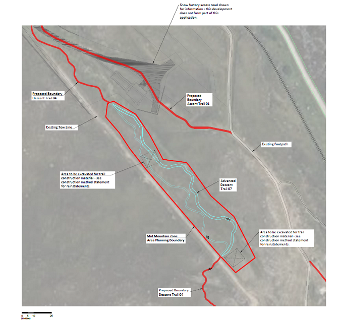
b) There is no ecological survey of the ground that will be affected although the “Covering Letter, Supporting Information” (see here) refers to an “Ecological Constraints Survey (Envirocentre November 2021)”. Perhaps the CNPA mistakenly forgot to upload the survey to the planning portal? The main supporting statement claims that “80% of the proposed bike park is on ground that has been manipulated by machinery during past skiing development”. The corollary of that 20%, ground in Coire Cas that has so far avoided being modified by human use, is going to be dug up for the first time while other parts are to be dug up all over again. There is no attempt to assess the impact of this on vegetation and slope stability (see here).?
c) The response from Highland Council’s Planning Team (see here) is worth reading in full. It is damning about the quality of the planning application:
“No information regarding access and transport has been provided. There is no information regarding additional trips this development will create and no information regarding existing facilities for public transport and active travel or deficiencies in the current provision for these modes.”
As it explains, the world has changed:
“The Climate Change Act sets a legally binding net-zero emissions target of all greenhouse gases by 2045 and a reduction in emissions by 75% by 2030. The Highland Council are legally obligated to help achieve these targets. Therefore, it is essential that conditions for walking, cycling and public transport are improved to reduce the amount of vehicle trips that this new facility will generate.”
The transport planning section goes on to make a number of modest recommendations including improvements to the core path connecting Coire Cas to Glen More, covered bicycle parking and the installation of bus shelters with real time travel information. This shouldn’t be difficult, HIE committed to improve public transport provision and path connections to Coire Cas in its masterplan for Cairn Gorm which it published last year- although few should be surprised that that now appears to have been forgotten.
(As an aside, whether or not the development goes ahead, if HIE was halfway serious about tackling climate change, all public buses up to Cairn Gorm should be fitted with ski boxes in winter and mountain bike carriers in summer, as happens all over the continent).
Some examples of the likely impact of the development
The Supporting Statement (see here) from CMSL, HIE and Ryden has a section on “Considerate Landscaping and Design”. This asserts that:
“The visual impact is mitigated by the proposed setting, situated within lower Coire Cas, which is flanked by the steeper sided ridges of the Aonach and Fiacaill a’Choire Chais”
That’s it as far as landscape impact is concerned. Actually, Coire Cas faces Glen More and Aviemore, but here I will give an example of the more local landscape impact:
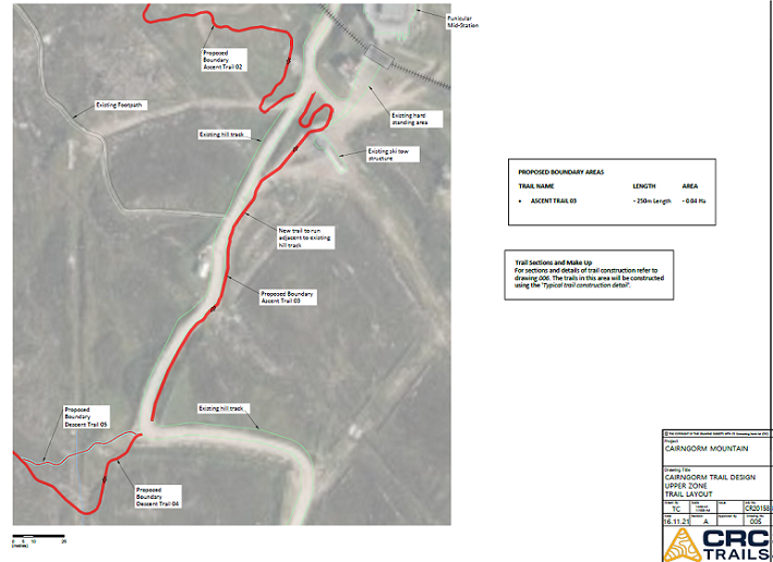
The proposal is that the top section of the ascent trail runs along the road up into Coire Cas the landscape impact of which I considered in The Cairngorms through the lens of Adam Watson (3) – Coire Cas, the long view. In effect CMSL is proposing to widen that road, which will increase its visual impact in summer.
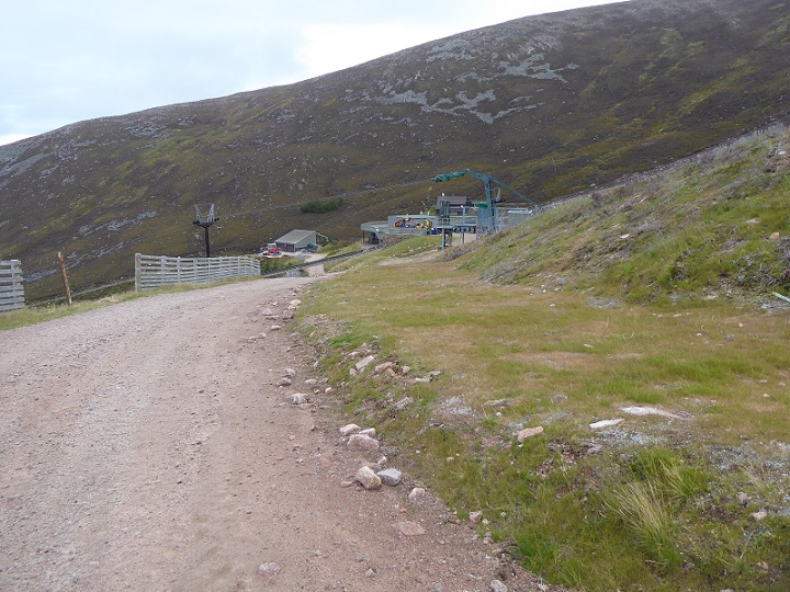
This is the same section of road/piste which Cairngorm Mountain Ltd, as it was then, modified and landscaped back in 2017. One cannot repeat enough HIE just treat Cairn Gorm as a neverending building site.
Just why a new mountain track is needed here, when vehicles on the mountain are supposed to be kept to the minimum, or what it will add to the biking experience is not explained. The section diagrams for the track don’t even explain its width:
At the very least it appears the footprint of the road, if this development was allowed to go ahead, would be widened by a further 2m, making it even more visible. Not what the National Park should be about.
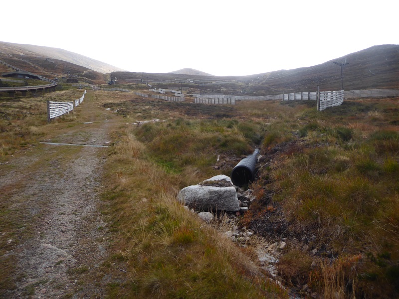
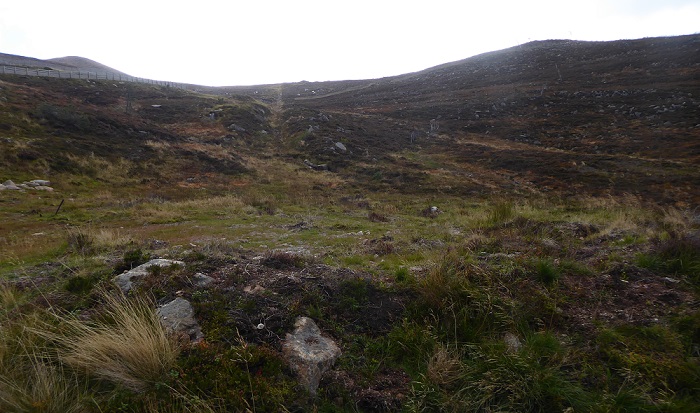
A second example. CMSL is proposing that Ascent Trail two (top map) will take a zig zag line up the ground between the Shieling Track and the snow fences and piste to the right. As you can see from the photo, the lower part of the proposed route is extremely boggy. That helps explain why one of the section drawings is for a “floating track”:
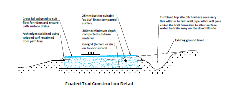
CMSL has made no attempt to assess what impact a floating track with drainage ditches will have on the peatland or what impact the zig zags will have on the landscape.
The impact of the learner zone in the area by the Day Lodge will be even greater:
There will be two conveyor belts – which as I have pointed out before should not be needed for bikes – with areas of hard standing at the top and bottom of each. Alongside the conveyor belt will be a new access road to the re-located snow factory, which CMSL says is not part of this application. It should be! The further development of this bit of ground by the Day Lodge should be considered as a whole, not piecemeal.
But the overall intention of all this clutter, together with the tube slides below, is clear. HIE are trying to turn Cairn Gorm into a fun park.
A misconceived plan that is bound to fail
I am not against the development of mountain bike trails at Cairn Gorm if linked to a new modern chair lift system, so long as any uplift for bikes ends half way up the ski area, i.e below the most fragile soils. Indeed, I believe that designing uplift that can be used for both bikes and snowsports is the only way the mountain business could ever become financially sustainable.
But this is not what HIE/CMSL is proposing. While they are right – as they state in the Supporting Statement – that there is a market/room for beginners mountain bike trails on Speyside, the idea that this should be located at Cairn Gorm is completely wrong.
First there is the weather, the best way to put any child off mountain biking would be to take them up to Coire Cas in the wind and the rain. A learners facility should be low down and creating one in Coire Cas is likely to result in yet more public money being washed down the hill.
Second, there is the impact of the trails on the ground. Beginners need wide smooth tracks at gentle gradients. The landforms that can support such tracks high up the hill are almost inevitably peaty or covered by fragile soils, exactly the places that mountain bike tracks should be avoiding. To make matters worse, the fines that are needed to surface such tracks to make them easy and safe for beginners to ride won’t last long in the wind and the wet.
Cairn Gorm is not the location for a sustainable beginners bike track. With appropriate uplift, however, it would actually be far better suited to the more advanced mountain biker who is more likely to be prepared to brave the mountain in poor weather and is capable of riding “hard” paths, engineered to be at far less risk of erosion. But that would require more investment and people in HIE who know what they are doing.

What troubles me about this planning application is that it repeats HIE’s inability to plan anything in Core Cas in a way that shows a grasp of the whole system in Coire Cas and beyond. This has been the case since it took over ownership of the ground in 1972. For example the proposal to develop Coire Cas as a mountain byking centre has implications for areas outwith Coire Cas. It will increase pressure on the northern Corries along already much used footpaths where people go for a quieter experience. It will also have implications for the lower part of the Glenmore Forest Park – of which Coire Cas is still supposed to be part. Walkers going on the route past Loch Einich in Rothiemurchus, even years ago, found their enjoyment much reduced by the mountain byke traffic – many on bykes hired in Aviemore.
Any mention of suspending or ending public access rights for cyclists?
There is nothing about implication on rights of access, whether CMSL intends to try and impose charges for using the tracks rather than the uplift or how any charging regime would be managed. That’s is just another failing in what is an incredibly poor quality planning application
I have challenged CNPA regarding the two landscape and ecology supporting documents missing from CNPA’s e-planning website. Surprise, surprise, the two documents have been loaded today – the last day of the public consultation. I have requested that CNPA’s Head of Planning agrees to at least a week’s extension of the public consultation to enable the public to view and comment on these two important supporting documents, but at 17.20 p.m. on 14 March I have as yet not received any acknowledgement or reply. This is a disgrace and for me further demonstrates the low regard CNPA Planning has in the public commenting process. Unless an extension of the public consultation is given, I have asked CNPA to treat this as a formal complaint.
In my haste, I meant to add the publication date of these two missing supporting document is stated to be 16 February, which is clearly untrue as they only appeared on the CNPA e-planning website today.
At last, CNPA Head of Planning responded to me at 17.55 p.m. this evening and has agreed that there is now a week’s extension to the public consultation on this planning application.
Is there not an issue with charging for use of the land ? So can you use the trails for free if you don’t use the uplift?