On 15th April 2021 the Balavil estate submitted a prior notification (see here) to Highland Council to create 2.6km of new forestry “tracks” around Creagbui, 3km northwest of Kingussie and north of the A9. This is the seventh planning application/prior notification for new roads on Balavil in the last six years. The Cairngorms National Park Authority (CNPA), which adopted a policy presumption against new hill roads in its Local Development Plan, did not “call-in” the “notification” despite being requested to do so by the North East Mountain Trust (NEMT) but left it to Highland Council to decide.
On 12th May Highland Council officers, apparently on the advice of the CNPA, decided that the proposed new roads required “prior approval”, i.e they wouldn’t just nod them through: they asked Balavil for details of the road construction and evidence that the proposals formed part of an approved Forestry Plan. It’s not entirely clear when Balavil responded but new information appeared on the Highland Planning Portal on 13th January and, after re-consulting the CNPA on the 31st January officers granted approval. (The report of handling shows that Highland Council consulted the CNPA and also that NEMT objected to the prior notification although that objection is NOT on the planning portal) .
The photos in this post – which I was sent last week and entirely by coincidence – and the recent history of road development on the site suggest that the information should have been scrutinised far more carefully and prior approval refused.
A road to manage native woodland?
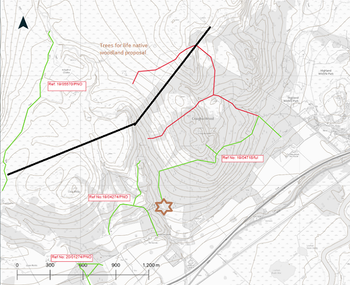
The “Supporting Information”added to the planning portal on 13th January includes a map of the proposed native woodland scheme. What this map and the map below show is that most of the proposed new road does not lie within the boundary of the woodland creation area:

Nor does the Supporting Information published on 13th January actually clarify, as Highland Council officers had requested, whether the woodland scheme has been approved by Scottish Forestry. It may have been but Trees for Life Woodland Services phrased their letter of support – it’s not the first time they have provided one to Balavil – very carefully:
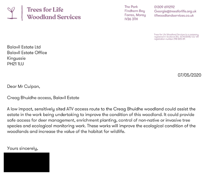
A low impact ATV track could assist with the woodland management! Trees for Life should have known there is already one there for much of the red route depicted on the plan, as photos from the Supporting Information show on the Planning Portal show: 
The Supporting Information from 1504 Building and Architectural Services, a small consultancy which was set up in 2017 (see here), claims:
“It is mainly intended that this track will assist in the mobilisation, planting and ongoing management in the estates long term woodland restoration plan on the Creag Bhuidhe/Craigbui Wood area as such the need to carry vehicles and plant into the area in order to undertake these tasks. Therefore the track should be to a standard that it can sustainably support the following vehicles:-
- Quads
- Buggies
- 4×4 pick up
- Plantation harvester
- Forwarding machine (when required)”
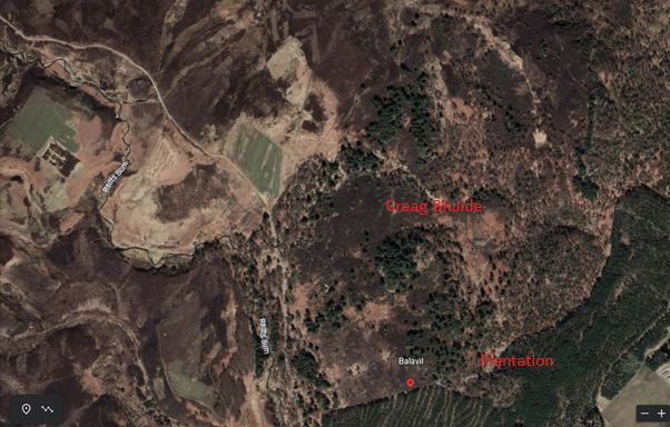
But why would plantation harvesters and forwarding machines be needed in an area 1504 claim is for native woodland? Google maps suggests that there is no plantation forestry anywhere in the vicinity of the proposed new road:
This road therefore – just like Pitmain’s current proposal to build a motorway behind Newtonmore (see here) – is NOT needed for forestry purposes and should have required full planning consent.
The Prior Notification in context
Officers should have been far more sceptical about this road particularly after Balavil had submitted an application for 7.5km of new roads in 2019 which was later withdrawn:

“Track 6” represents the road that at the time was planned for Creag Buidhe and was 1.2km long. With a northern prong being added to the Prior Notification that increased the proposed road by 1.4km. This is less track creep, more track explosion. Knowing that more was in store, makes the decision by Highland Council and the CNPA decision to continue to approve tracks on a one-off basis without insisting on an overall plan even more negligent. There is a crying need for all estates in our National Parks to produce overall management plans which are then subject to public consultation.
Here for reference are the eight road applications to date:
| Date submitted | Planning Reference | Full or prior notification? | Length | Description | Decided by |
| 2016 | 16/04569/PNO | PN | 7kms | Repair to Raitts Rd | Highland |
| 2018 | 2018_0400DET | Full | 5km | Extension Raitts over watershed to Dulnain | CNPA |
| 2019 | 19/04036 | PN | 7.5km | 8 tracks | Withdrawn |
| 2019 | 19/04274 PNO | PN | 1.494km | Upgrade – felling licence produced | CNPA |
| 2019 | 19/0347 | Retrospective in part and full | 1km | Croftcarnoch Plantation track | CNPA |
| 2019 | 19/05570 | PN | 1.9km | Creag Bhalg track upgrade | Highland |
| 2020 | 20/01274 | PN | 142m | Short pgrade | Highland |
| 2021 | 21/01816 | PN | 2.6km | Creag Buidhe | Highland |
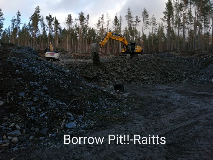
Roads and borrow pits
Roads of course have to be constructed out of something, with all the machinery and destruction that goes along with that, which explains why there is now a large borrow pit on Balavil.
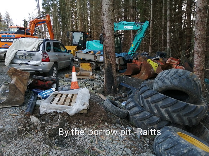
This large quarry by the Raitts Road, however, does not appear to be shown on ANY of the seven plans for new roads that have been passed by the planners over the last six years. Instead, most of the road construction plans in those proposals stated that the material needed for them will be “won” from new drainage ditches alongside them or from local borrow pits:
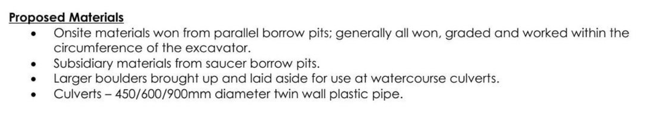
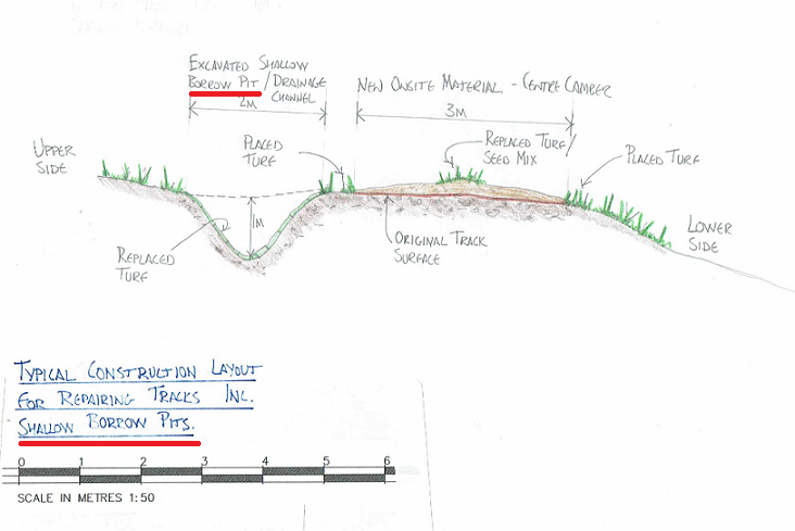 Similar drawings, all claiming to follow SNH’s “Constructed Tracks in the Scottish Uplands”, have been submitted for most of the roads proposals This is what the Supporting Information from 1504 stated about borrow pits for the Craigbui road proposal:

You would never guess from the claim that this methodology avoids “hauling large quantities of imported material long distances” that there was in fact a quarry, which appears in regular use, at Balavil! The weasel word is “most”: most of the material will be obtained from shallow borrow pits. In fact, in some of the other road applications/prior notifications there are references to a “designated borrow pit”, though I have been unable to find any information about its location, who approved it and how it might be restored in due course.
It is presumably the quarry in the photos and that it should have “slipped through” the planning process is something the CNPA should investigate.

When Dave Morris and I met the estate in 2019 because of our concerns about the new road round the Croftcarncoch plantation (see here) we were not told anything about the quarry, it’s not marked on the maps for that new road and there is no mention of it it in the supporting information (see here). That contains similar words to all the other track applications:
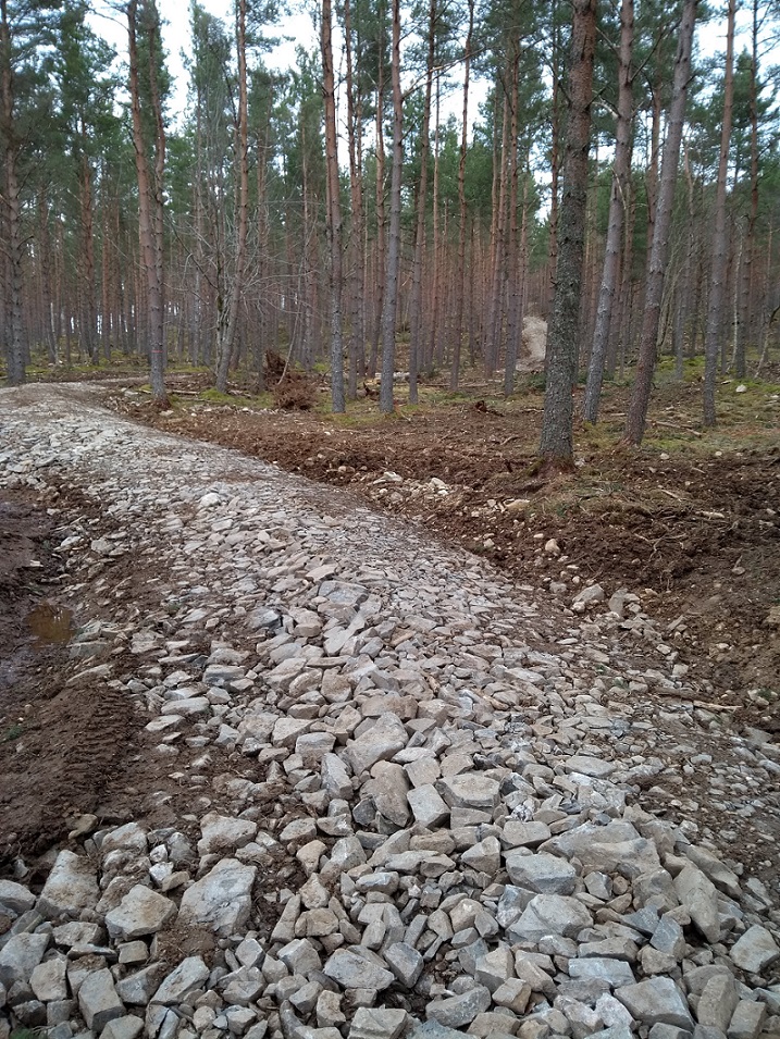
There was no mention of this new quarry either within the report that went to the CNPA Planning Committee, yet within 3 months of the application being approved, the Croftcarnoch road, which runs out of the borrow pit area, had clearly been constructed from materials quarried from it:
I wonder if CNPA Board Members are aware of this?
The CNPA, having approved this new road, should have monitored its construction and, had they done so properly, might have been far less relaxed about allowing subsequent Prior Notifications for forestry tracks to be decided by Highland Council. If Balavil start using material from this quarry to upgrade/construct tracks around Creag Bhuidhe, that would appear contrary to the plans that were submitted as part of the prior approval process and should enable both Highland Council and the CNPA to take enforcement action.
So what is the real purpose of the Creag Buidhe road?
Although mostly not within the boundary of Trees for Life’s native woodland scheme, as depicted in their map above, native trees have recently been planted around Creag Buidhe and the Prior Notification states this is being done with Trees for Life:
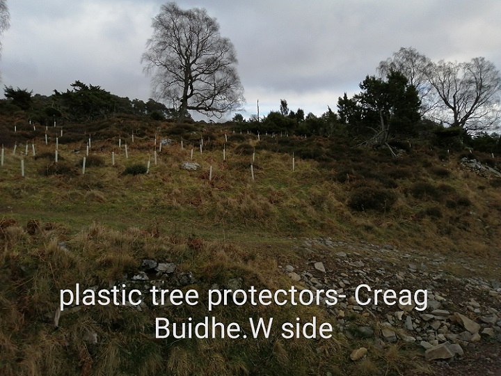
According to the BBC (see here) Trees for Life “hardly ever uses plastic tree tubes” – so why is an organisation that claims to be promoting re-wilding in Scotland doing so here?
As I have been arguing for the last year, we need to get rid of plastic tree tubes and our National Park Authorities should have been taking the lead on this. Had the CNPA called in the planning application for the tracks around Creag Buidhe they could have asked Balavil for more detail about their proposals and ascertained whether they were going to help the state natural environment (carbon, nature, pollution etc) or harm it.
This photo shows that it is not just the new road and its likely impact on landscape, drainage etc which is the issue. By washing its hands of so-called prior notifications for forest tracks the CNPA is abandoning the opportunity to influence woodland practice for the better and so undermining its own statutory objectives. When Forestry and Land Scotland announced at the end of last year that they are going to stop using plastic tree guards this is simply not good enough.
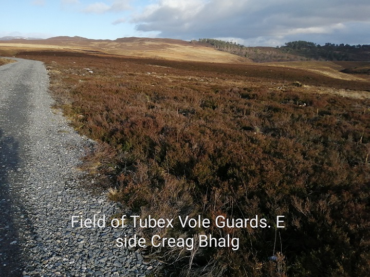
Incidentally, plastic vole guards are also being used over to west on Creag Bhalg which IS within the Trees for Land woodland regeneration area as depicted on the map:
New roads, of course, aren’t necessary for one off operations like planting trees, whether plastic guards are being used or not.
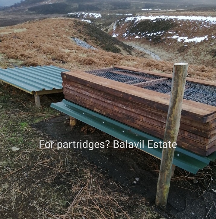
In my opinion the real reason for most of the new roads on Balavil is to allow gamekeepers to get around quickily and easy, both to feed pheasants and partridges and to “manage” the animals that prey on them. There is plenty of evidence for that on the ground if CNPA officials were allowed to look (it’s not the fault of planning staff that they don’t get out of the office enough). When I went to look at the half-constructed road round the Croftcarnoch plantation in 2019, as it was prior to receiving retrospective planning permission, pheasant feeders had been installed close to the section of road. Now new breeding pens are being installed:
If you want to understand what is driving the new roads on Balavil or Pitmain for that matter, it’s not woodland creation, it’s the intensification of field sports. Pheasant and red-legged partridge need woodland. In their draft National Park Partnership Plan the CNPA to their credit recognised that the release of non-native gamebirds into the National Park was having an adverse impact on the natural environment and committed to investigating how this could be brought under control. One simple way they could achieve this would be to use their planning powers to refuse permission for new roads and call-in every single prior notification for new roads by sporting estates that are allegedly for forestry purposes.

This post demonstrates how there has been a complete failure by successive goverments, over decades, to control hill road construction. This is why our world famous landscapes are being rapidy degraded by private and corporate interests while our politicians stand idly by.
Aye, just another phase in the farce of our non-national ‘national’ park, the embedded role of the VED regime within it, and how NGOs becoming part of the Establishment, become part of the problem
hill tracks!? –‘you ain’t seen nothin yet folks’. Next will be the tracks leading up to the high corrie lochs to be used as giant cisterns for the ‘eco-wonderful’ pump storage systems, to back up the intermittent wind production. And, it’s not just the tracks, these schemes will basically destroy or radically alter aquatic Arctic-alpine habitats containing unique invertebrate-amphibian associations 12,000 years in evolution and probably even less altered than the terrestrial habitats of the high tops and plateau
Brilliant stuff Nick; keep going; terrifying prospect re corrie lochs Ron; we should all be very worried; harfly a river runs free thanks to so called eco-friendly hydro. RW
indeed Robert, very scary
I know it’s not dismissive of this particular situation but not sure “you ain’t seen nothing yet”and the following fits the bill.
One point in many.These Balavil tracks will be glaringly evident from the increasingly popular Creag Bheag at Kingussie. The pine crested ridge of Creag Buidhe is such a fine element of the scene up and down the Strath.
And what are they for, these tracks. “sport’?
The recent storms have toppled some fine ancient pines on Creag Buidhe. Climate change.
How are we to rapidly seek to address intermittency of electrical supply without pumped storage?