In my posts (see here) and (here) criticising the Loch Lomond and Trossachs National Park Authority Board for abandoning their decision-making role and allowing senior staff to take control, I was aware of a recent exception to the rule. At the Planning Committee on 30th August (see here for papers) Board Members rejected a recommendation by staff to refuse planning permission for a path and viewing platform at Trossachs Pier, Loch Katrine, by five votes to three.
The decision offers a glimmer of hope for democracy over bureaucracy though unsurprisingly LLTNPA staff didn’t issue a news release. That was left to the applicants, the Sir Walter Scott Steamship Trust (see here). They referred to a site visit and a three and a half hour meeting (!) but diplomatically avoided mentioning that Board Members had overruled staff. Unfortunately, due to the culture of secrecy within the LLTNPA, there is no recording of the meeting available to view online and as yet no minute. This post takes a look at the issues.
The Roderick Dhu proposal
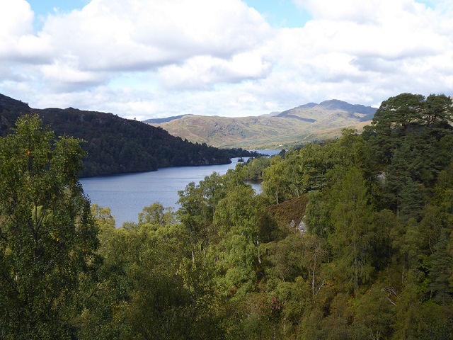
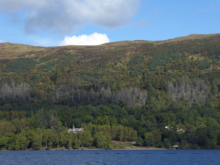
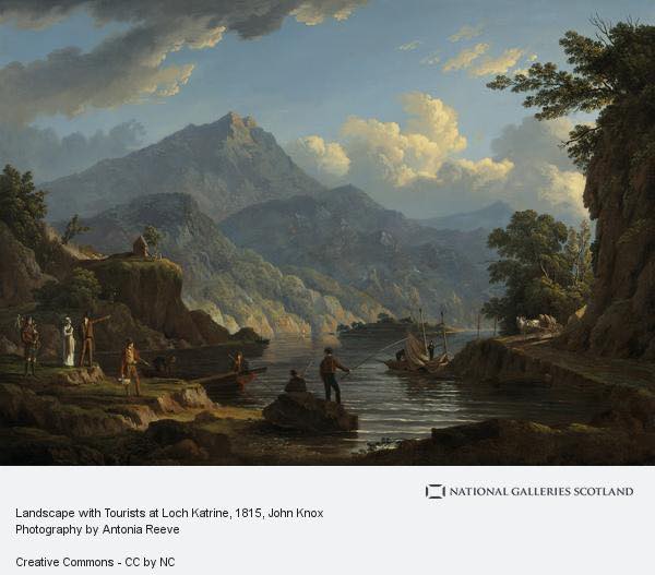
The Sir Walter Scott Steamship Trust lease land around Trossachs Pier from Scottish Water. The planning application proposed to construct 188m of path from the car park up Craig Leven, an adjacent glacial knoll, and construct a viewing platform on the summit to enable visitors to look out over Loch Katrine. There is literary and artistic evidence that there was both a path and a viewing platform in Victorian times, though very little is still visible on the ground, and that previously the knoll had been used as a watch point, hence why the Steamship Trust named their proposal after a local clan chief, Roderick Dhu.
 Last September, at the invitation of the Steamship Trust, I went with a footpath expert to look at the site before the Planning Application was submitted. The proposed path forms part of a wider set of proposals to improve the groaning tourism infrastructure in the Trossachs, including the car parks below Ben A’an and had securing funding through Visit Scotland’s Tourism Infrastructure Fund.
The idea of building a path and viewpoint was sound in principle. Trossachs Pier has good facilities and has lots of visitors but at present the only real walking opportunity for the general tourist – as opposed to adventurous explorer prepared to go bushwacking through the woods – is the track around Loch Katrine. The proposal offered visitors the opportunity to experience a short woodland walk with a fantastic view at the top. Just the sort of thing the National Park should be encouraging.
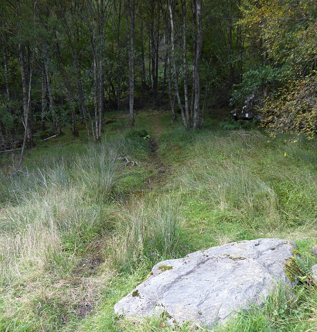
After walking the line of the proposed route, it was clear that constructing/reinstating the path would pose technical challenges because of the nature of the terrain. Our view – and I deferred to the footpath expert here – was these were not insuperable, if planned properly and built by people with the right skills. We both had concerns, however, that the construction could well cost more than initially estimated.
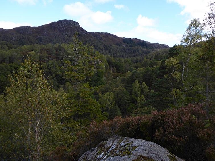
The terrain – with steep drops on most sides – and trees meant a walkway and viewing platform was the only real option to enable people to enjoy the views safely from the top.
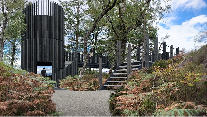
Because of this, if there had been an alternative site nearby, we might have suggested the Steamship Trust consider that. Those same trees, however, also mean the viewing platform, as long as it was constructed out of wood, would have very little landscape impact.
The Trossachs Special Area of Conservation
Craig Leven and the area around Trossachs pier was designated a Special Area of Conservation (SAC) under the EU Habitats Directive. The SAC is managed by Forestry and Land Scotland (FLS) on behalf of Scottish Water and the documentation on the NatureScot website tells a tale (see here):
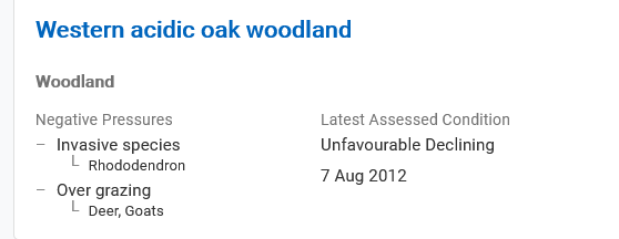
While it should be of concern that NatureScot has not assessed the site since 2012, FLS in responding to the application (see here) accepted that the site is still in unfavourable condition due to overgrazing. This is confirmed by the Habitats Regulation Appraisal (HRA) from the LLTNPA’s own ecological adviser which forms Appendix 2 to the main planning report and states:
“the site requires the restoration of the shrub layer and age structure of the woodland, through reduction on herbivore impacts and increased regeneration of woody species.”
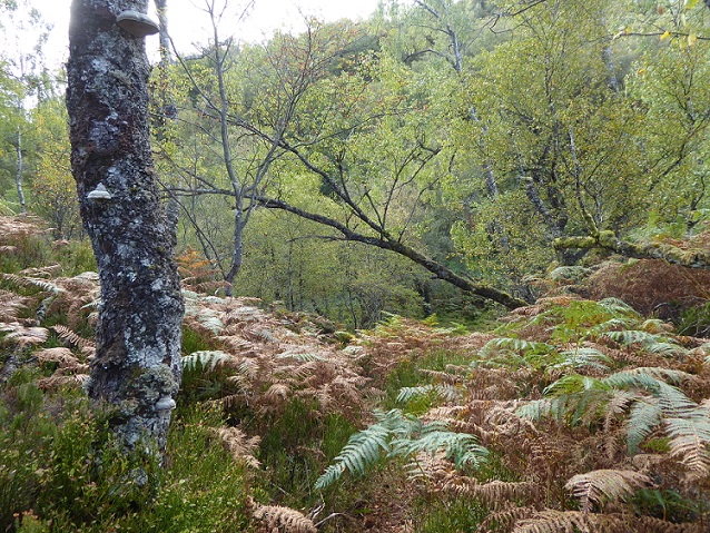
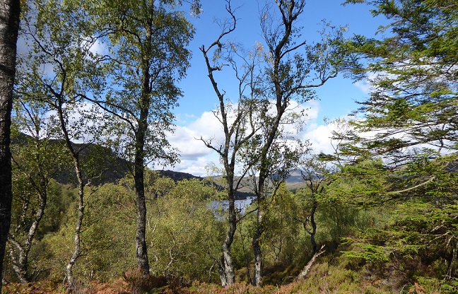
The HRA confirms what was clear from my visit and is visible in the photos, that birch woodland predominates. While associated with oak and a component part of the SAC, it is of some relevance that the classification of vegetation on Craig Leven is not actually oak. There are no old oak trees, which support more species than any other in the British Isles, threatened by the development. But two ash trees, which are dying as a result of the ash die-back disease, would be removed.
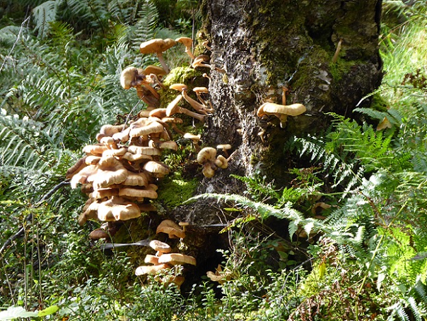
Strangely, after emphasising the threat of invasive rhododendron, the HRA makes no mention of Forest and Land Scotland’s failure to manage non-native conifers that can now be found on Craig Leven:
Where the Habitats Regulations Assessment is spot on, however, is in its statement that:
“There are opportunities for an increase in the extent of qualifying habitat [for the SAC] through clearance of non-native conifer plantation surrounding the SAC. Bracken and rhododendron suppress tree regeneration and out-compete other shrubs and ground flora. The extent of oak woodland habitat can be increased by reducing bracken cover and removing rhododendron.”
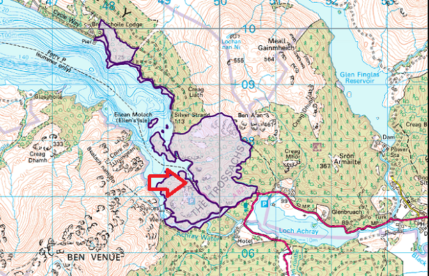
The map of the SAC shows the oak woodland east of Benachoile Lodge is separated from that around Trossachs Pier. The SAC was fragmented from the moment it was created. Neither the letter from Forest and Land Scotland nor the HRA state what has been done to address what should have been the fundamental conservation challenge, how to expand the existing oak woodland and join it up.
It is worth noting that none of the Planning paper suggest that outdoor recreation is responsible for the SAC being in unfavourable condition.
EU law, protected sites and the planning system in the Loch Lomond and Trossachs National Park
The general approach of the LLTNPA towards developmental impacts on the natural environment in the National Park at present could be summarised as follows:
- unless a proposed development is located within a designated European site (SAC and Special Protection Area for Birds), the presumption should be that it can go ahead;
- where a development outwith a SAC or SPA might impact on it, ask for lots of paperwork, but then let it go ahead anyway with a few requirements to mitigate the impacts, e.g the Cononish Goldmine (see here), where the LLTNPA gave the go ahead for Scotgold to create ten enormous spoil heaps just above the River Tay SAC;
- for developments on other types of protected site, find a reason for it to go ahead, e.g the housing on ancient woodland by Balmaha (see here) which was consented on condition FLS undertook compensatory planting………….in the Trossachs!).
Having criticised for the LLTNPA for failing to pay sufficient attention to conservation in the past, it may seem strange that here I am criticising the planners for using the SAC designation to refuse a development. But a footpath is a very different type of development to a gold mine or even a house. That is common sense and the public recognise that: there were 157 letters of support for the application, including many from local people who care about the environment as much as anyone.
While staff from NatureScot started down the same course as the LLTNPA and claimed that the footpath would damage the integrity of SAC, to their credit, after site visits, they changed their mind and withdrew their initial objection.
The legal basis of the officers recommendation in this case
Planning officers concluded, on the basis of the HRA that the path and viewing tower would have:
“an adverse effect on the integrity of the Trossachs Woods SAC. The proposal will lead to lasting and irreparable loss to a part of the SAC. While relatively small scale in terms of the physical footprint of development, relatively small scale losses of habitat can adversely affect the sites integrity.”
This argument was based not on scientific evidence about the site but on European case law. As stated above, the path is to be constructed through what is predominantly birch woodland, a relatively short-lived tree, and through a fair amount of bracken. No evidence has been produced to indicate that any rare species would be affected. If someone had found a very rare plant on the line of the path I’d be the first to say change the route and if you can’t, don’t build it. But in the absence of such evidence it should be obvious that any loss of habitat causes by the path could have been compensated by expanding the SAC elsewhere (even if the SAC mechanism is so bureaucratic that it would probably take years to recognise this officially!).
Two legal cases were cited to support the LLTNPA’s conclusion. The first, known as the Waddenzee Judgement (see here), considered when a Habitats Regulations Appraisal is required and the implications of that. It concerned the impact of mechanical cockle fishing – a very destructive activity – on the sea bed and sea birds. The second, Sweetman v An Bord Pleanala (see here), concerned the potential destruction by a new road of 1.47 hectares (out of a total of 270 hectares – 0.5%) of protected limestone pavement and ruled that this would have an adverse impact on the site’s integrity. Both cases, incidentally, refer to the importance of scientific evidence and the need for objectivity.
The HRA reaches the reasonable conclusion that the path and platform would impact on 367 squares metres of ground. It doesn’t, however, explain that this is 0.367% of a hectare or c0.097% of the Trossachs Oakwoods SAC which covers an area of 377 ha (see here). I understand one board member at the planning meeting picked up on this and pointed out the area concerned was equivalent to 1.5 tennis courts in an SAC area covering 10,000 tennis courts!
While the the HRA was in many ways commendably thorough – its goes into the potential impacts of the path on soils, drainage etc (“the heavy mass of stone pressing down on the soils below would affect the hydrology of the soil“) – there is no sense of perspective, no comparison for example between the potential impacts of a path and the continued overgrazing by herbivores. Moreover, it asserts and assumes that the impacts/damage of the path will be permanent. This when the LLTNPA could find almost no evidence of earlier paths or the viewing tower on the hill!
Accepting that this path will require stone to be imported, there is a difference between blowing up limestone pavement or scraping the sea-bed clean and constructing a path. NatureScot was in my opinion absolutely right to change their view and conclude:
“that the path and/or its construction will not result in any loss of extent of qualifying habitat (the key conservation objective). No functioning woodland habitat will be lost. The proposal will result in changes in the qualities of the habitat; some loss of structure and ground flora, in a very limited area within the protected area, but in our view these changes are de minimis in relation to the functioning of the woodland ecosystem within the overall site” (see here)
The shame is that whoever did the author of the HRA rightly outlined the potential for the Trossachs oak woods to expand, through the removal of conifer plantations and rhododendron and reduction in grazing pressure. But the planners, instead of doing something imaginative to promote this and compensate for the path, like requiring the Steamship Trust to organise volunteers to help remove rhododendron within the SAC, were fixated on the detail and their own bureaucratic interpretation of “the rules”. They lost sight of the wood because of the ground vegetation between the trees.
Vested interests exposed
Both the LLTNPA and FLS have statutory duties to promote public recreation and enjoyment of the countryside. The regional office of the FLS responded to the planning application (see here) in an extraordinary letter which is worth quoting at length:
“we have significant concerns about the proposals and feel it would be contrary to our position managing both national and European designated sites and priority habitat. The proposal is within the Ben A’an and Brenachoile SSSI and the Trossachs Woods SAC, both currently listed as being ‘unfavourable declining’ condition”.
Comment. The FLS has in the last few years undertaken work by the new path up Ben A’An to remove conifers and replace by native trees in woodland that is coterminous with the SAC/SSSI (see here). While the work has in my view been brutal, it would appear that FLS believes it has done no lasting damage to the site and in time the woodland could recover and become part of an enlarged SAC. The FLS letter doesn’t explain why, if the Ben A’An path won’t adversely impact on the “integrity” of the enlarged woodland, the much shorter Roderick Dhu path should impact on the integrity of the SAC?
“This is a remote area, difficult to access, that is not currently visited by tourists or anyone generally beyond FLS staff. Our database shows that the woodland here is also considered to be Ancient Semi–natural (ASNW) and is listed in the native woodland survey for Scotland (NWSS), both indicating upland woodland , which is also priority habitat.”
Comment. Remote? The path will take people 180m from a car park. As for Ancient Woodland Inventory, yes it was the predecessors of FLS, who agreed to sell their ancient woodland site at Balmaha for housing (see above).
“Our experience of similar constructions leads us to conclude more tree and woodland scrub and ground flora vegetation loss is to be expected, and that significant work (and therefore larger impact) would be required to safely construct a robust a steep footpath (which would require robust drainage measures) and large watch tower structure.”
Comment. This may be true, but both the Ben A’ An and Ben Ledi paths (see here) were machine built, which impacts on a far greater area than hand built baths, and as parkswatch has documented far from robust. Perhaps FLS needs to learn from others rather than criticise?
What follows is even worse:
“Operational Phase
We also have concerns over the long term viability and expected liability of managing both a new
visitor attraction here and the associated requirements for public use. Once constructed there
would be a burden to ensure the health and safety of the users. This means constant maintenance
of the single steep path, which experience tells us is likely to become braided with use (e.g. as
seen on Conic Hill). Erosion as walkers step off the path to avoid each other (more likely in a post –
Covid context) could lead to the path becoming wider over time resulting in a larger impact on key environmental features. Vegetation clearance of the path will also be required seasonally and the integrity of the path itself, being so steep, will be expected to require at least annual maintenance.
Similar paths elsewhere usually become a channel for water flow and as we are seeing more
extreme and unpredictable weather, this poses a reasonable risk to path usage and how it can be maintained over time. This would also need an adjustment to drainage measures to adapt the
changing path size and line.
The watch tower would also need regular checks on structural integrity and work to ensure safety
on a regular basis. We also presume there would be an expectation to maintain the view from the
tower, which includes cutting back vegetation (i.e. more impact on the ecological interests of the
site). Once at the top, the safety of visitors roaming the site will be considered and it’s not
unreasonable to expect a fence might be required for public safety, which also means an increased
impact footprint of the overall development. We’ve seen elsewhere that when an area is opened
up to visitors, there is also a corresponding desire to explore further and wild camp“.
Comment: the clear message is that the FLS, driven no doubt by inadequate budgets, now sees the provision of recreational infrastructure as a problem and is using safety, maintenance, liability and even climate change as an excuse for withdrawing from supporting paths. Had they been making the case for recreational infrastructure, they might have been among the first to receive some of the 10% of the Transport Budget that the Greens, in their agreement with the SNP, have got allocated to walking and cycling. As for the exploring further and wild camping remark, besides betraying a fundamental failure by a government agency to respect access rights, just where does FLS think people will camp on this terrain?
“Upon discussion with our wildlife ranger manager, it is clear such a proposal would affect our own
efforts to control both herbivores and INNS [invasive non-native species], which are listed as the main threats to the designated sites. FLS has already spent a considerable amount of time and resource to reduce the presence of both, and while we can see the evidence of our efforts working, the presence of visitors in an area currently remote is not expected to be beneficial. Any anticipated herbivore displacement would be primarily during daylight hours and is expected to tail off as the animals become acclimatised to the presence of people. Visitors, especially non–local tourists, can also be found feeding herbivores (both deliberately and inadvertently through littering), which could eventually
draw in these animals. If there is any displacement, it could push these animals into other more
sensitive and difficult to access sites nearby. Additionally, the presence of such an increase in
people could interfere with an already challenging programme for control (which already works
around seasonal constraints).”
Comment: set aside the lack of evidence and the contradictory arguments (visitors both displace and attract deer), any impact on herbivores would affect at most 2 ha out of a 377 ha site and could be managed.
To be fair to the LLTNPA planners, they didn’t use FLS’ arguments to support their recommendation but focussed on the alleged threat that a path would have on the “integrity” of a European site.
The importance of democracy for conservation and our planning system
There are some signs that the LLTNPA Planners are taking the conservation objective more seriously when it comes to planning decisions. For example, they presented another report (see here) to the same meeting on the proposed windfarm north east of the village of Strachur, outwith the National Park boundary. Having previously noted a failure by the LLTNPA to comment or object to renewable energy developments just outwith the boundary (see here for example), it is good to see planning staff following the example of the Cairngorms National Park Authority, and recommending Board Members lodge an objection because of the impact on the landscape within the National Park.
The problem, however, is that generally the system has become all about the theoretical application of planning “rules” divorced from the actual impact on the ground. This has been coupled with Scottish Government performance imperatives that favour development (new jobs, renewable energy etc) and has resulted in EU designated sites becoming about the only legitimate reason for refusing planning consent. A prime example of this was that the LLTNPA was content for the original Flamingo Land proposal for Balloch to include development in Drumkinnon Woods, an unprotected site, but one highly valued by local people and visitors and with great ecological potential. After the public outcry, Flamingo Land has now been forced to repackage their proposal to exclude the woods. This is a victory for democracy, although Lomond Banks as they now call themselves still hope to use the planning rules to turn what is now a public park into a chalet park – post to follow).
This I believe illustrates why we need to put democracy, rather than bureaucratic rules, including those surrounding SACs, at the centre of the planning system, not just in our National Parks but more generally. The common sense view of what matters and what doesn’t, really does matter, whether this is about inappropriate developments such as Flamingo Land or the Hunter Foundation Leadership Centre on the south shore of Loch Lomond or a short footpath in the Trossachs. The decision of LLTNPA Board Members to overturn officers recommendations on the Roderick Dhu path is a welcome step in the right direction, but now they need to start thinking about how they can address the democratic deficits in the planning system in the LLTNPA more generally. Comparing how they operate with the Cairngorms National Park Authority – where Board Members regularly overturn or amend officers’ recommendations – would be a good place to start.

Excellent summary and analysis Nick. Thanks for that highly informative post. It’s always hard for committees to lift their heads up and see the wood instead of the trees, which is where good leadership is essential – something we’ve often seen lacking in LLTNPA. The board taking the initiative by themselves will be hard work to sustain, but let’s hope it results in leadership improvement some time in the future to support them.
17/10/2021 Your local peasant , I was told to have nothing to do with you Nick , you were a dangerous man ! REMEMBER ! Thank the All Mighty you are , again excellent analysis , really great work , you must be working round the clock to achieve the output I read . I hope you can recruit an army of helpers for this IS the year of huge change .Please send on all info to The Ferret and other investigative journalists , you now need to broaden your range of topics under your microscope . Hope you are well , visit when you have time . Regards , M .