Highlands and Islands Enterprises (HIE) are at it again as evidenced by the latest planning application, to repair the funicular (see here for papers).
It has been noted many times in the past that HIE have a habit of pre-empting decisions being made about operations at the Cairngorm Mountain ski resort, currently being operated under the name of Cairngorm Mountain Scotland Ltd (CMSL) and funded by the taxpayer.
It is now quite obvious from the 100 plus planning documents that HIE were proceeding with a policy of repairing the Funicular at any cost even as they were appointing the Masterplanners to formulate a Master Plan and leading stakeholders and the public to believe that their input would be taken into account (see here).
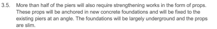
The planning application consists of a number of documents. This post looks at three of them, the Site Location Plan, the Planning Statement and the Application Supporting Information
Site Location Plan
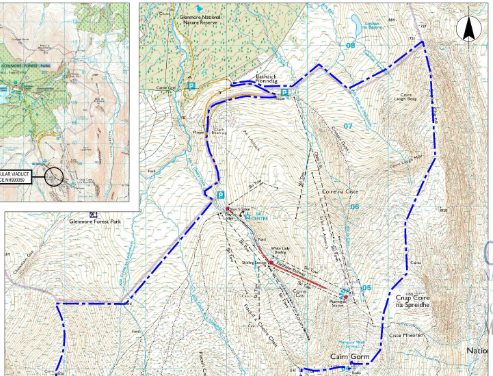
As the name implies this document shows the area of Cairn Gorm under the control of HIE, the blue line is its border, which you would expect to be an up-to-date overall view of the area including skiing infrastructure. Yet it shows tows and lifts that no longer exist! It gives the impression that there is a lot more uplift than is actually available.
Planning Statement.
1. Introduction
“The operation of the Funicular delivers a significant economic contribution to the local and regional economy, and it is essential in providing all-season access and accessibility to Cairn Gorm.” (para 1.4)
Alan Brattey in his post on this planning application (see here) demolished the first part of this claim. The second is not completely true either. For the last fifteen years the funicular has been the main way to access the Ptarmigan restaurant and ski area after the introduction of the core lift policy and subsequent demolition of the Ciste chairlifts in 2017. However, whether its essential is a different question. There is an alternative (see here), a 6 person chair/ 6 person chair/ 8 person gondola hybrid. This would be significantly cheaper to build than the ESTIMATED cost of repairing the Funicular, more environmentally friendly and also, most importantly, more user friendly, particularly in the ski season as it has a higher capacity. This also makes it more profitable/financially viable. These are facts which HIE and CMSL are completely ignoring in their blind and dogged determination to repair the Funicular.
2. Site Description
Application Site Boundary (Paras 2.4, 2.5 and 2.6)
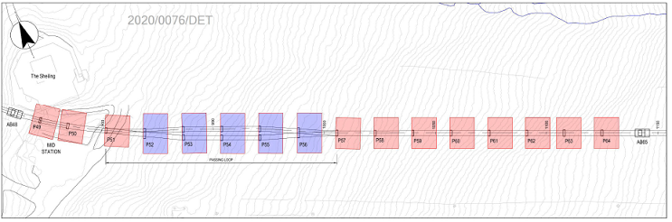
Instead of showing the entire working area, with access tracks etc, HIE have only included in the application the areas around the piers supporting the funicular.
This is highly unusual, indeed wrong, as usually the entire working area is included in a Planning Application, as happened with the Shieling Rope Tow. It appears HIE has done this to reduce planning fees as the larger the site, the larger the planning fee.
Even so, HIE have misrepresented the size of the area. I have counted and the plans show 55 piers, and 2 anchor blocks (AB14 & AB29), marked in pink, total 57, and, 5 piers which are part of the passing loop marked in blue (see above). That is a total of 62 rectangular areas, 60 piers and 2 anchor blocks. Yet Para.2.5 states that there are 65 rectangular areas, 60 piers and 5 anchor blocks, so apart from the two shown on the plans, AB14 and AB29, what size are the work areas for the other three missing anchor blocks and which ones are they out of AB 0, 48, 65 and 78?
The pink areas are 11m x 14m = 154sq.m. Pink areas = 8,778sq.m.
The blue areas are 11m x 18m = 198sq.m. Blue areas = 990sq.m.
Total area = 9,768 sq.m.
If three anchor block work areas have been missed off the plans, their combined area will be 462 sq.m. (154 x 3) and will bring the total work area to 10,230 sq.m.!
3. Proposed development.
This section is a basic explanation of the works to be carried out and includes a statement that says “some of the strengthening counts as repair work and does not require planning permission”. This includes work on the bearings and strengthening the beams, even though that work will require use of machinery that will impact on the ground round about.
It goes on to state:
There are two important points that are missing from this, and other parts of the planning application.
(1) There is no size given for the diameter of the props or their snow retention.
The props have to be of a suitable size to support the weight of the structure to stop it falling over in the future and adjustable in length, not only to take up any slack, but also to be able to push the piers up in the event that they start to lean further over! And,
(2)There is no mention of the snow clearing needed. This second point is in my opinion more important. The extra props being proposed will increase the amount of snow build up at every pier that is being strengthened. It is suspected that use of the piste basher used in snow clearing operations may have caused some of the damage to the piers. Extra snow occurring at these locations will lead to even more clearing operations, which will now have to be done manually, thereby increasing the time taken for the train to become operational in heavy snow and/or windy conditions. This will inevitably mean more skier days lost, customer dissatisfaction increasing and a loss in revenue to CMSL. A former employee of Cairngorm Mountain Ltd commented on a Facebook post that it felt as though he had spent most of one season doing nothing else but keeping the track clear!
4. Development plan policy
Several section are actually repeated almost word for word in different paragraphs:-
Policy 2: Supporting economic growth -Para. 4.6 repeated in 4.15,
Policy 4: Natural Heritage. Para 4.8 repeated in 4.16, and,
Policy 5: Landscape. Paras 4.9 and 4.17 repeated in paras 4.9 and 4.18!
The document is even thinner on content than it looks!
5. Assessment against Planning Policy
This repeats a number of assumptions such as the funicular is important to the local economy, the work will have no adverse environmental impacts [Ed. the subject of a post later this week!]. There is, however, one very accurate statement :-
![]() That one sentence is exactly why the funicular should not have been built in the first place and should now be removed before a huge sum of money is wasted on its repair. It is a visibly intrusive structure, that can be seen from miles away, and is not therefore suitable in a National Park!
That one sentence is exactly why the funicular should not have been built in the first place and should now be removed before a huge sum of money is wasted on its repair. It is a visibly intrusive structure, that can be seen from miles away, and is not therefore suitable in a National Park!
6. Conclusion.
The conclusion repeats assumptions made earlier in the Planning Statement with presenting any facts to support them.
Application Supporting Information
The screenshot shown below is part of the supporting information and is totally inaccurate:
 .The Funicular consists of 88 piers and 5 anchor blocks, excluding the base station. As 60 piers need strengthening that is over 2/3rds not the “approximately half” being claimed.
What needs to happen.
The plain and simple facts are a chair/ chair/ gondola hybrid is a less expensive alternative to the funicular repair, would be preferred by skiers and probably by tourists too as the gondolas would not be so crowded. It could be built before the funicular needed to be dismantled and could then be used to remove the demolished funicular components off the mountain. It should even be possible to utilise some of the existing buildings. It would be less visually intrusive from close up, and afar, and would help to return snowsports enthusiasts to one of Scotland’s national treasures, with all the added bonuses to the local economy that the funicular has lost.
When the Funicular was built the final cost to HIE was more than twice the original estimate! With an initial estimate for repair of £9.6m, which then increased to £10.7m when some other necessary work was added in, plus the cost of the Ptarmigan upgrade estimated at £2.5m, where will that leave other businesses in the HIE remit? And what if the final cost for repair increases to double that amount as happened last time? Even at a repair/upgrade cost of £13.2m how can HIE justify spending that amount of money when the economic impact of the Coronavirus to the Highland economy (see here) may not be known for a long time?

Graham, I believe the issue you raise about the site boundary being wrongly described is of more significance then you state. The under-statement of the ‘site boundary’ being the area around the pillars etc. amounting to approx. 1 hectare in total is not just about reducing planning fees, but what HIE is trying to avoid is making the application site the subject of a Major Development as defined by the The Town and Country Planning (Hierarchy of Development) (Scotland) Regulations 2009. This application falls into the category of a Major Development if the site area is 2 hectares or over.
A major application has an increased requirement for supporting documents including increased environmental impact documents. In my view the access roads etc in this application are all legally part of the planning application. Scottish Planning Series Circular 5 2009: Heirarchy of Developments has the following definition in para 13:
In the Schedule of Major Developments the term ‘area of the site’ is used for measuring some of the thresholds or criteria against. Regulation 1(2) defines site as “the land to which development relates”. Development is defined in section 26 of the 2006 Act as “the carrying out of building, engineering, mining or other operations in, on, over or under land, or the making of any material change in the use of any buildings or other land, or the operation of a marine fish farm”, subject to a set of seven exceptions of operations or uses of land which do not constitute development such as local authority or statutory undertakers works.
If there is any material change to any of the access roads, then these must be included in the site boundary. CNPA has no discretion in defining a Major Development. The most appropriate class of Major Development is the last one called “Other Development” (see paras 35 and 36 of the above document. the criteria which makes this a Major Development is the site are being over 2 hectares.
If CNPA has treated this application as a Local Development, then the application should be withdrawn. In my experience CNPA will try to hide behind Highland Council and say that it was Highland Council’s task to evaluate what category of development this was.