With the Funicular currently out of action and its future unknown, the recently published SE Group addendum into uplift a Cairn Gorm (see here) is ostensibly recommending the creation of 8.7 hectares of new ski terrain in Coire Cas as part of their revised plans. This post explains why this figure is wrong and far more ground will be affected.
The new beginners zone
Besides the new runs, “Additional grading or summer grooming” is also recommended to create the large new beginner zone. “Terraforming” is another term to describe what is proposed. In layman’s terms this means rock and heather removal, presumably using bulldozers and possibly even muirburn, with the potential to create new water courses but to certainly alter the landscape.This shows that the SE Group, despite their international reputation, do not seem to understand the concept of a National Park or what it means to a lot of people.
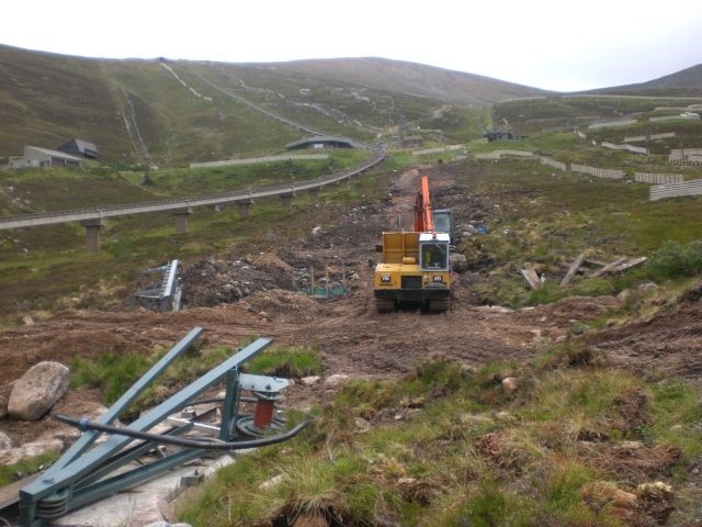
The picture above shows work in progress in 2015 to create the shieling rope tow and what “summer grooming” to create the new beginner area may involve. The area proposed in the SE Group report (see map below) runs from the Shieling down to the Daylodge area, and from the Funicular track across to the Car park tow, just visible on the right, i.e. a much wider and longer area than that affected by the creation of the Shieling rope tow.
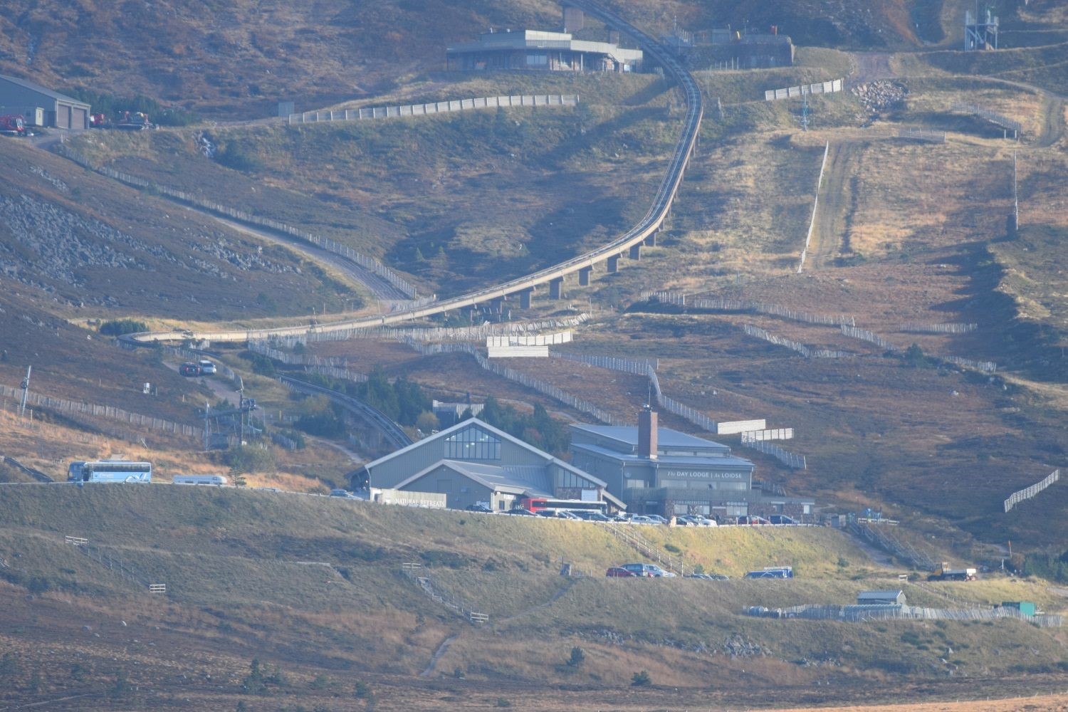
A view of the area affected is shown in the next picture and gives a better idea of how much “summer grooming” will be required, although the lower part of the Car park tow is not visible. The lower boundaries for the area will be roughly where the snow fence is on the far right and the zig zag fence just to the right and above the Daylodge.
Within this an area of approximately 3.1 hectares proposed for snowmaking. What will happen on the rest is anyone’s guess. There is no statement in the SE Group addendum as to how or how much material will be removed, and maybe deposited somewhere else or used to fill in depressions to “create a smoother surface”.
The new ski runs
As I pointed out at the beginning, the proposal is for 8.7 hectares of “new terrain associated with Lift B”. The following tables list the positions for the terrain improvements and snow making, the area affected in hectares and the costs of snowmaking and terrain works. A hectare incidentally is 10,000 sq. m. :-
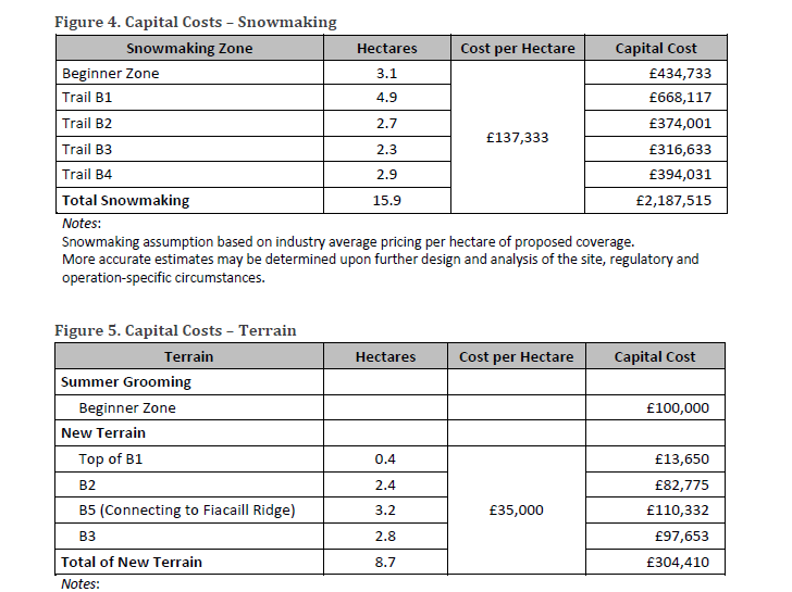
Looking at the second table on terrain costs there is no figure for the size of the beginner zone, so I had assumed from the Snowmaking chart that it is 3.1 hectares or 31,000 sq. m. I have now done a rough measurement of the size of the beginner zone and found it is probably over 6 hectares or 60,000 sq. m. This would alter the row for “Total of New Terrain”, including the beginner zone, to approx. 15.0 hectares or 150,000 sq. m., not 8.7 hectares, (strangely enough the area proposed for snowmaking is 15.9 hectares), and a capital cost of £525,000 not £404,410.
If we take a look at the map of the proposals, its very poorly labelled. The “new terrain” at the “top of B1” referred to in the table presumably means the area from the top of Lift B to the top of the current Cas tow.
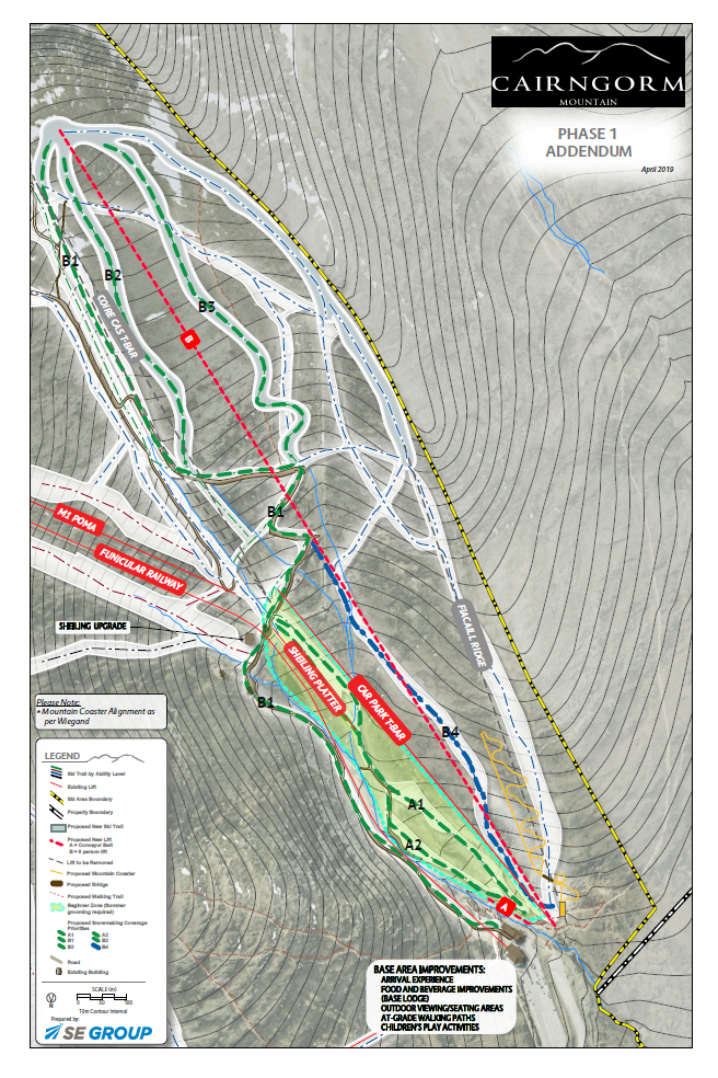
Runs B2 and B3 are completely new terrain and have dimensions, by my measurements, of approximately (B2) 700m long x 34m wide, and (B3) 800m x 35m, which comes to about what is quoted in the table. However, while B2 is 2.4 hectares it needs 2.7 hectares of snowmaking, whereas B3 is larger at 2.8 hectares and yet only requires 2.4 hectares of snowmaking!
The status of run B4 on the map is unclear because although its shown as an existing run there is nothing on the ground where it is depicted The snowmaking table describes it as comprising 2.9 hectares or 29,000 sq. m. If that were added to the new terrain table, that would increase the “total of New Terrain” to almost 18 hectares or 180,000 sq. m. and the capital cost to £630,000.
B5 is not shown on the map either but appears to run from the top of lift B to…. where exactly? The table describes it as “connecting to Fiacaill ridge” but from the size and colour of the area shown on the map it appears that it should have been described as “connecting to the top of the Fiacaill Ridge tow”. Not quite the same!
Correct me if this already exists, but the map is also showing a run that starts off from the top part of the Fiacaill Ridge tow up track for about 1/3rd of its length but then veers off to one side only rejoining near the bottom of the lift! Is this new terrain as well? If it is then it has not been included in the new terrain figures and, as it looks roughly the same size as B5, could add another 32,000 sq. m. at a cost of £112,000 giving a “total of new terrain” of about 212,000 sq. m. and a capital cost of £842,000.
Also not mentioned is the laying of water pipes and electrics for the snow guns and snowfactory and the ground they stand on or the groundworks needed for the new uplift. There must be other things I have missed. Either way the amount of ground affected is not the 8.7 hectares we are being lead to believe and the costs are likely to be far more than those quoted .
Conclusions
In my opinion, all this terrain grading, summer grooming, terraforming, call it what you will, has the potential to be a huge environmental disaster for Coire Cas and the Cairngorm National Park. The ski terrain already exists in the Ptarmigan/ Ciste ski area so why cause even more destruction?
It has been pointed out to me that it is not a sensible idea to take beginners to the top of Coire Cas on lift B, and then expect them to ski the almost 2km back down. How long would it take them to do that?
The sensible option for uplift, with the Funicular out of action, is to build a chairlift to the Ptarmigan with a mid-station at the Shieling allowing the Shieling Platter to be brought into use for the beginner area as was available in the past, leaving all other tows intact. This also allows use for summer visitors. The money saved from NOT demolishing the Cas and Fiacaill tows and all the associated terrain grading, could be put to better use on that uplift allowing access to the whole mountain when skiing is available and less damage to the mountain as a whole.

Reference the recent blogs about the funicular railway.
I seem to remember the results of the 1984 Lurchers Gully Inquiry. The outcome was that the Cairngorm Chairlift Company Ltd were not allowed to extend the road from the carpark to Lurchers Gully. However, the company could build anything they liked in the unprotected areas of Coire Cas, Coire na Ciste and Coire Laogh Mor and these areas are still unprotected. Ski areas form a minute part of the high ground in Scotland.
When the planning for the funicular railway started there was uproar from conservationists. Whilst businesses and many local people supported it, conservationists made it as difficult as possible for the planners to make fair and balanced decisions. The planning conditions have made it impossible for the funicular to make a profit, which in my calculations has cost the public purse £37 million so far.
It was often said by local people at the planning stage that conservationists were trying to sabotage the funicular. Well, it has taken 18 years to achieve this.
When planning any building it is the site that should be considered, not any damage that could be done to the surrounding area, by the imagination of planners and conservation bodies, especially, now we should be complying with the Land Reform (Scotland) Act 2003. To emphasise my point HIE claim 200,000 people a year use the carpark and do other things on the hill. That means 3.4 million people have probably entered the protected area which is only 100 metres from the carpark since the funicular was opened. Why couldn’t people leave the Ptarmigan that is not in a protected area? The protected area starts over the summit of Cairn Gorm.
For eight years HIE tried to sell the Cairngorm Estate and failed. Probably, due to another crazy planning condition that required the owner to remove the funicular if it was closed for three years. The funicular must be repaired because it would be cheaper to repair it than remove it.
The funicular saga has some similarities to the long running Lingerbay super quarry debate of the early 2000s. It was accepted, in a legal debate, that SNH could not give an impartial judgement on the planning application when they were the principal objectors, due to members of the SNH board being officials of conservation charities. Exactly the same can be said of the handling of the funicular planning application by the SNH. I suggest that the same could be said for other decision making bodies. Regardless of whether or not the Section 50 and VMP are legal agreements, both documents now merit a legal challenge.
It would appear to me that conservationists selfishly want the hills to themselves and do not want visitors to enjoy the high tops and the magnificent views. When I hear people complaining about the damage to the landscape in Coire Cas and Coire na Ciste I have to question their thinking. There have been lifts, tows and many fences in the coire since the 1960s, any future construction may even improve the appearance of Coire Cas. Coire Cas should be a major income for the area, instead of a drain on the economy which it is now.
Perhaps, while the funicular remains closed, the responsible bodies can sort out the VMP so that the Ptarmigan area and Coire Cas can become a first class visitor attraction that we can be proud of. It should also be capable of supplying jobs for our younger generation in this unprotected area of Cairn Gorm.
In conclusion, this area is part of a “Park for All”.
Thank you for that information.
It illustrates to me why the current impasse (economic) continues to exist.
You obviously know a lot more than I do about the protected/ unprotected areas around Corrie Cas and Coire na Ciste, but this post is more about the damage that could be done to the landscape/ environment if the work proposed is not done sensitively and not restored as near as possible to the condition it is now, or even improved.
I have also revised my estimate of the size of the “beginner zone” with more accurate measurements from 6 hectares, or 60,000sq.m. to 77,330sq.m. increasing the area for new terain to in excess of 229,000 sq. m.
I can’t see that the summer visitor trade will want to look at or walk in a huge area of Coire Cas that has been bulldozed to give a smooth un-natural surface. The fact remains that this is a National Park and as such should be kept as natural as possible and not left to look like the photo at the beginning of my post.
I also don’t think it is fair to say that the conservationists tried to sabotage the Funicular. People were advising before it was built that it was an economically unsound proposition and it now looks as though they were correct, especially when costs went from the estimated figure of £9m to its eventual cost of £26m+, the business going bust in 2008, almost finished in 2017 and again bust in 2018. The Funicular is not entirely to blame for the business failure.
What has happened in the past can’t be undone, but we need to learn from the mistakes and look for a sustainable, economically viable solution which is acceptable and will also require a degree of compromise by all interested parties. The alternative is that we could be back here again in another 10 years, or even less.
The funicular was a vanity project and I for one would have preferred being dragged up the hill naked by a horse.
Graham reference your response. Slight correction to your information. The projected cost was £19 million which increased to £26 million.
I would agree that anything built in this unprotected area must be built to a high standard. However, I re-emphasise that this is an unprotected area and planners must not treat the area as a protected area thus increasing the cost. If tourists had been let out of the Ptarmigan I am quite sure the facility could have made a profit with people using the train many times. The facility was built to increase summer use.
To put Natura 2000 sites into perspective. 39% of the Cairngorms National Park is covered by EU designations. 300,000 people (SNH figures) enter Rothiemurchus Estate, each year, which is covered by the same designations as the Cairngorm Plateau and there does not seem to be any significant problems. In addition, there are 239 Special Areas of Conservation (SACs) in Scotland, and, with the exception of access being denied to certain sites on Military establishments, I am not aware of any which restrict walkers on the grounds of conservation.