The consultation process
The Loch Lomond and Trossachs National Park Authority approved its statutory core path plan for consultation at its Board Meeting on 18th September. The 12 week consultation commenced two months later on 23rd November when a link to the Plan appeared on the consultation section of the LLTNPA website (see here). The deadline for responding is 15th February.
The consultation has not been widely advertised. No announcement was made on the News section of the LLTNPA website (see here) and its unclear what, if anything, the LLTNPA has done to alert the wider public who enjoy walking, cycling, horse riding and other recreational activities about the consultation. Details of two drop-in sessions this month are so hidden on the website that I cannot find them again to give the link! What appears to have happened is that the Park’s Access Team have distributed copies of the consultation to their contacts but have been given little or no assistance from the LLTNPA’s large communications team to promote the consultation. This is not the fault of either the Access or Communications Team but a fault of management.
On the plus side, the consultation is based around a map which shows existing core paths and the proposed changes and is really easy to use (see here). This is a considerable improvement on the current core paths plan maps which are clunky (see here). The staff concerned should be congratulated. If you want to see what’s proposed in any area of the National Park its only a few clicks away. I hope lots of people will do so.
This post will take a more detailed look at what is proposed around Ben Ledi.
The proposals for Ben Ledi and its environs
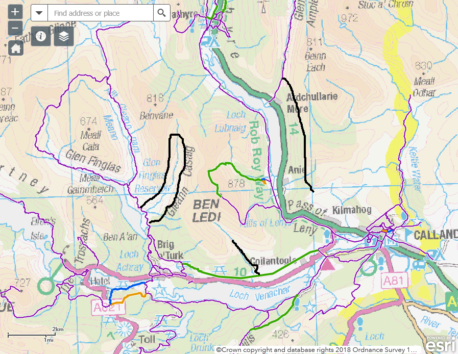
I have taken Ben Ledi as a starting point for considering the plan because, within the context of hydro schemes, I recently pointed to the missed potential for linking tracks into the path network there (see here). I have also previously commented on the potential for linking the forest tracks east of Loch Lubnaig to Callender (see here).
There are three main additions included in this section of the map, the path to the summit of Ben Ledi via Stank Glen, the Great Trossachs Path on the north side of Loch Venachar and a section of the Rob Roy Way on the south side of Loch Venachar. These are all welcome.
Their selection does however raises important questions. What paths are chosen is supposed to be determined by 10 criteria which were endorsed by the Local Access Forum. A “path must score more than 4 on 6 or more criteria to qualify as a potential core path”. You can see those critieria and how each path has been scored by clicking on the line on the map on the Park’s website (excellent!). Here is the information on the Stank Glen path to Ben Ledi and how its been scored:
| Proposed change | addition |
| Proposed change reference | ADD15 |
| Identified by the community as a priority | 5 |
| Provides for a specific recreational use, as a primary use | 5 |
| Provides enjoyment of the Parks special qualities | 5 |
| Promoted for visitors and tourism linked activity and contributes to economic linked benefits | 5 |
| Provides useable links with the public transport network | 0 |
| Provides a functional route/link | 0 |
| Provides a link (or part of a link), between settlements including cross boundary | 0 |
| Provides a short route option close to or within settlements or visitor hubs/destinations | 2 |
| Forms a key link (or part of) to a wider network of paths/routes or strategic longer distance routes | 2 |
| Balances landowners interests with exercising access rights | 4 |
This path only scores 4 or more on FIVE of the criteria and therefore does NOT according to the Park’s policy qualify for being added to the core path network. No doubt someone in the Park will claim there has been a typographical error somewhere to save face. However, I believe that its not the scoring that is the issue but the criteria used. These which don’t allow for paths like the Stank Glen route up Ben Ledi to be added to the core path network.
The problem is that relatively few of the LLTNPA’s criteria apply to the recreational experience. Ben Ledi is relatively easy to climb, very accessible to people who have a car, offers outstanding views and is as a consequence one of Scotland’s most popular hills. In recreational terms it deserves at least a circular route up and down but in my view would also benefit from a number of alternative paths (like similar hills in the Lake District). This would help spread the load and enable people to experience the mountain in different ways. However, only the second and third of the LLTNPA’s 10 criteria apply to the recreational experience. If the local community and landowner had not supported this path and tourism interests promoted it, it would have failed even more miserably to meet the LLTNPA’s criteria. That explains why only three hill paths in the whole of the National Park are included in the core path network, Ben Ledi, the Cobbler and Ben Lomond.
This failing could be addressed if the LLTNPA created additional recreational criteria to evaluate a path’s importance. For example,
- Its popularity (and the extent to which regular path work/maintenance is required (being a core path does not create any requirement for the Access Authority to maintain it but could be used to prioritise paths which need investment)
- Encouraging more people to get out into the great outdoors (with all the physical and mental health benefits that provides)
- Providing alternative routes to spread/manage visitor pressure
- Breaking down the single criterion about “Providing enjoyment of the Park’s special qualities” into a number of separate criteria such as “Enjoyment of landscape”, “enjoyment of nature” and “enjoyment of the cultural heritage”.
- A route has been endorsed in a Planning Application as adding to the recreational experience (e.g as has happened with many hydro tracks)
That would enable additional core paths to be added to some of the large blank areas in the north and west of the National Park. These do not fit well with the Park’s stated aim (see here para 4.2) that core paths should:
“provide the public with reasonable access throughout the National Park”.
Actually, our National Parks should be aiming to provide world class paths alongside Scotland’s world class access rights (outside the Park’s camping byelaw zone that is). That however would would mean doing things like joining up the path and track network, for example joining some of the green and purple lines on the Park’s map to the black lines showing tracks.
Its worth noting here that one of the justifications for the horrible hydro track up Gleann Casaig, which I have marked as a black line even though I believe it should be removed, is that it would create a new circular walking route. If that was really true, why has it not been added to the core path network? There is still almost no join up between the LLTNPA as a Planning Authority and the LLTNPA as an Access Authority. The recreational experience in the National Park would be greatly improved if the worst hydro roads were converted into paths no more than 1.5m wide (i.e suitable for ATV use only) and linked into the core path network.
The re-alignment of the core path at Forest Drive (bottom left of map), raises further questions about the LLTNPA’s criteria and scoring system. While the direct link to Brig O’ Turk (blue line) makes sense, the former route (brown line) no longer meets the criteria. The change results from a re-aligning of the National Cycle Network and, simply because the brown path is no longer promoted as a national route, it now drops out of network (meeting only 5 rather than 6 of the ten criteria). Actually, it adds to people’s choice, so why remove it? If the LLTNPA had adopted more recreational based criteria, it would not have to propose that routes like this were removed from the path network.
What can people do to help improve the core path network?
The Ben Ledi example shows that the LLTNPA still has a long way to go before it provides a world class path network and a primary reason for this is that the criteria it has adopted exclude paths important for outdoor recreation. This is not to say that paths linking communities and endorsed by local communities are not important. They are. But we need both, paths around and linking settlements and paths that get people out into the wider countryside.
The underlying explanation for this failure comes down, I believe, to resources. As a result of austerity and how budgets are allocated, the LLTNPA is in the business of downplaying expectations. This is not the fault of frontline staff. What we need are National Park Boards which make the case for resources, for example that what is spent on walking should, like cycling, be measured against what we spend on roads. If a tiny proportion of the money that will be spent on the A82 upgrade or fixing the Rest and be Thankful was spent on paths, the path network in the National Park would be transformed.
To the LLTNPA’s credit, the first question in the consultation is whether the core path network is sufficient. I hope people will answer no and in a further post (or two) will cover some of the major gaps in the core path network in the North and West of the National Park. We then need people to make suggestions as to what paths should be added and, if they don’t fit the criteria, to use this as a reason for changing the criteria.
Start looking at those maps now (here is the link again) – the consultation closes in four weeks.

Drop in sessions are detailed here https://www.lochlomond-trossachs.org/park-authority/publications/core-paths-plan/respond-to-the-consultation/