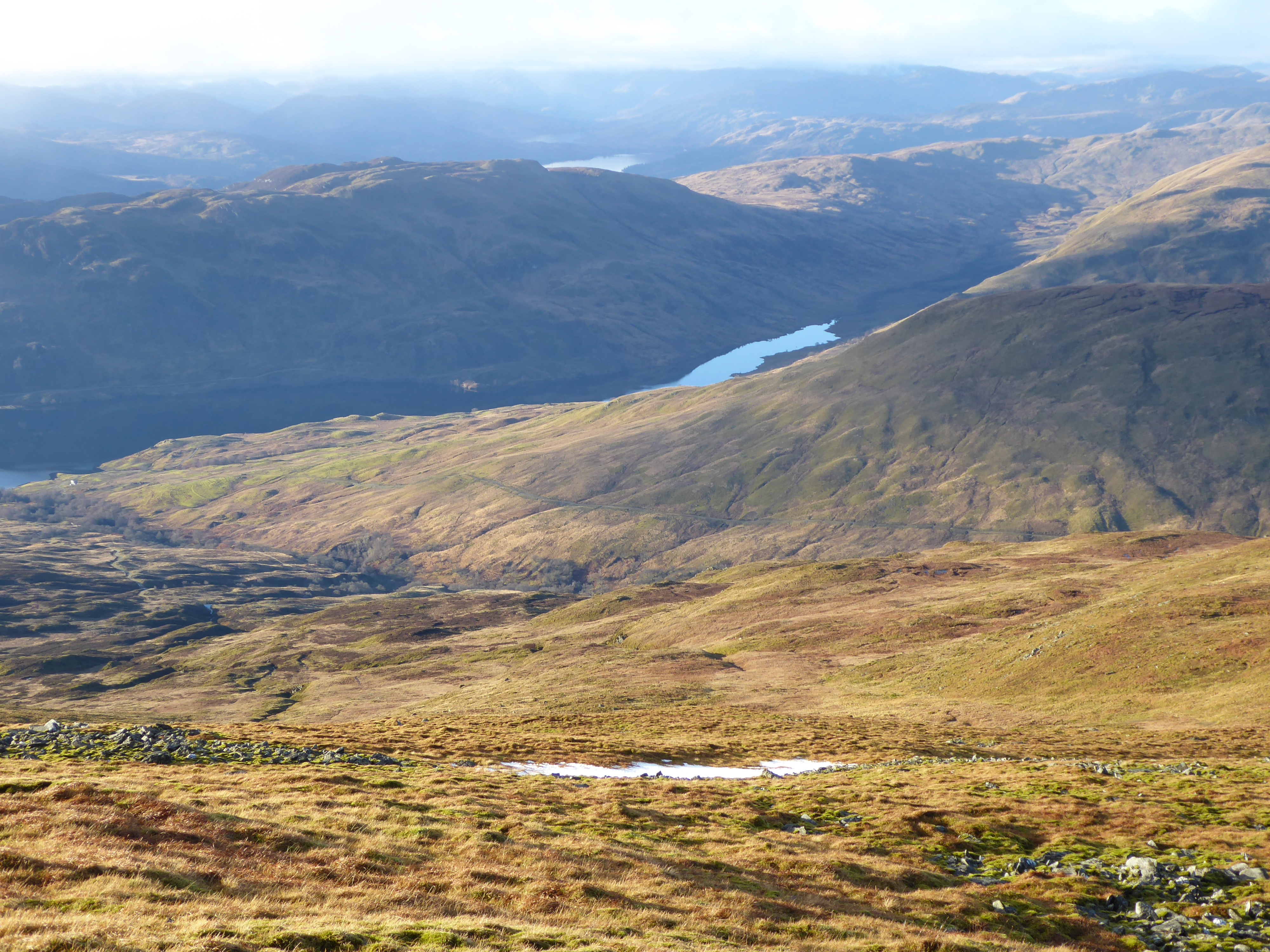
I was up on Ben Ledi on a fine day just before Xmas and my walk got me thinking about the cumulative impact of the new run of river hydro schemes. There are three on the flanks of Ben Ledi: Gleannn Casaig to the West, Stank Glen to the north east and Milton Glen to the south. After considering each scheme individually, I will consider their cumulative impact on Ben Ledi.
The Gleann Casaig hydro scheme
Back in October 2017, in a post on the Gleann Casaig hydro scheme (see here), based on photos provided by Jim Robertson from the Munro Society, I commented that:
“In track construction terms, the new track up Gleann Casaig is in my view better than most……………The problem though is that in planning terms (see here for all papers) this track is supposed to be a footpath and that the LLTNPA [Loch Lomond and Trossachs National Park Authority] gave consent for a new footpath into a wild land area without any proper consideration of the impact on landscape or wild land……………….The LLTNPA not only decided there would be no impact on the landscape – the top photo [above] shows that this is NOT true – it also decided there would be no impact on wild land:”
Fifteen months later the view from the top of Ben Ledi, one of our most popular and iconic hills, confirms that the LLTNPA made a serious error by allowing this hydro construction track to remain.

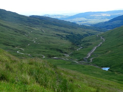
The new and unnecessary “path” now forms what will be a permanent scar across the hillside. While the vegetation on either side of the track will recover further, reducing the width of the scar in time, the problem is this new track takes a straight line across the hillside following the buried pipeline. This is a landscape of curves. Leaving a straight cut across it is nothing more than vandalism. A proper path, which took a more sinuous line, would have stood out less.
The motivation for retaining this track, however, was not to create a great new recreational resource (there is no link to Ben Ledi path at the top of Stank Glen) but rather to save on the costs of restoring this line. Removing the track and replacing it with a sinuous path would have up far too much of the hydro profits which we all pay for through our fuel bills.

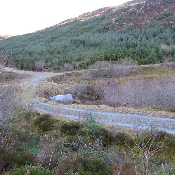
Glen Finglas is owned by the Woodland Trust and the lower section of track could become concealed by trees over time, though there is not much sign of regeneration at present. Even if this were to happen, a straight track through the woods would still provide a poor recreational experience compared to a path where you don’t know what is around the corner.
The Trossachs is one of Scotland’s most renowned landscapes – and this part of it is now a National Nature Reserve to boot – and this track should never have been granted consent. Unfortunately the LLTNPA has been blind to the consequences these tracks have for the landscape and the destruction which has taken place under its aegis. It could make amends though by entering discussions with the Woodland Trust with a view to removing this track. This could then provide a demonstration project and precedent for removing some of the other disastrous hydro tracks that have proliferated in the National Park.
Stank Glen Hydro Scheme

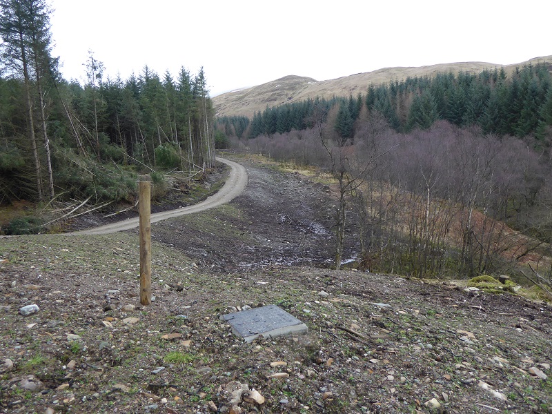
The landscape impact of the Stank Glen community hydro scheme is far less. This is partly because it is located lower down the glen but also because it lies within forestry and used existing forest tracks (which is not to say that the landscape impact of forest tracks is acceptable). The scheme was therefore located in a place where it was unlikely to have significant additional impacts.

I first visited the scheme two years ago, after a friend told me they thought it was a good example of a hydro scheme. I formed a similar opinion then but was taken aback before Xmas to find that no further snagging or improvements had taken place in the last two years:
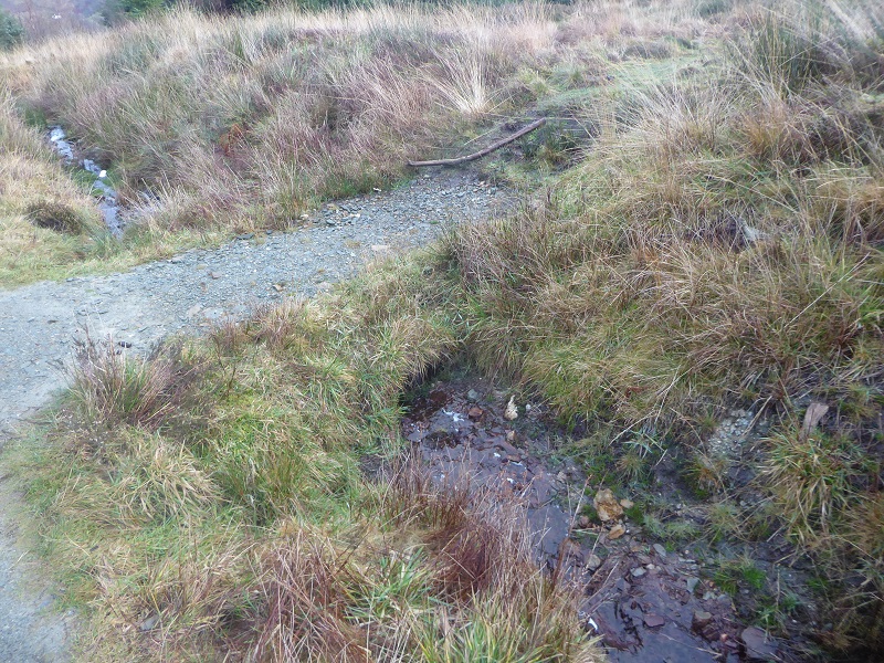
 The main issue then was the area below the intake. It is still a mess with little attempt at restoration although at least there is not road extension to the intake itself. There is yet another blue pipe, contrary to the Park’s award winning good practice guidance on renewables. The banks of the burn still look as though they have just been hit by a bulldozer. This is not a place you would want to stop for a picnic.
Maybe the reason for the LLTNPA’s inaction is because there seems little point landscaping the hydro intake when the forestry infrastructure around is just as bad if not worse:
One might have hoped, that with the flow down the burn greatly reduced, someone in the LLTNPA might have seen the opportunity to re-engineer/landscape this culvert. The LLTNPA however rarely views developments as an opportunity to remedy past damage to the landscape. Moreover, in respect of forestry the LLTNPA has taken very little interest in the impact that industrial practices have on the landscape of the National Park:
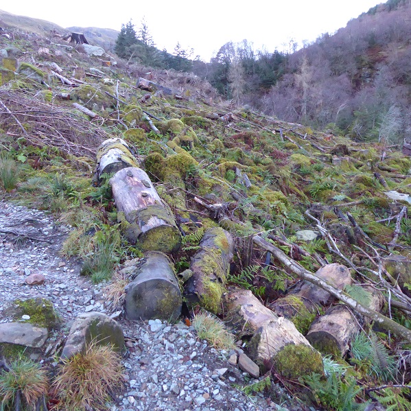
Scenes like this rarely occur in Europe where a different approach is taken to felling trees. The problem is that so long as the LLTNPA do not see industrial forestry as a problem they need to tackle, why would they be concerned about hydro schemes and their tracks?
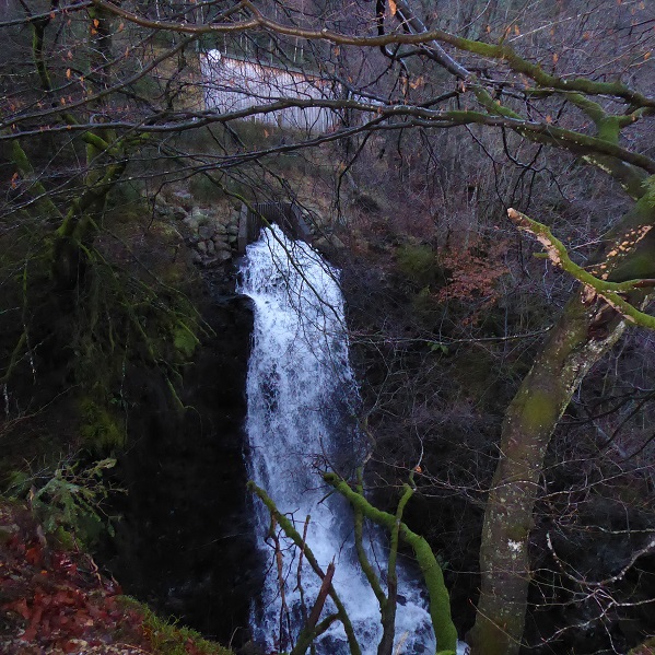
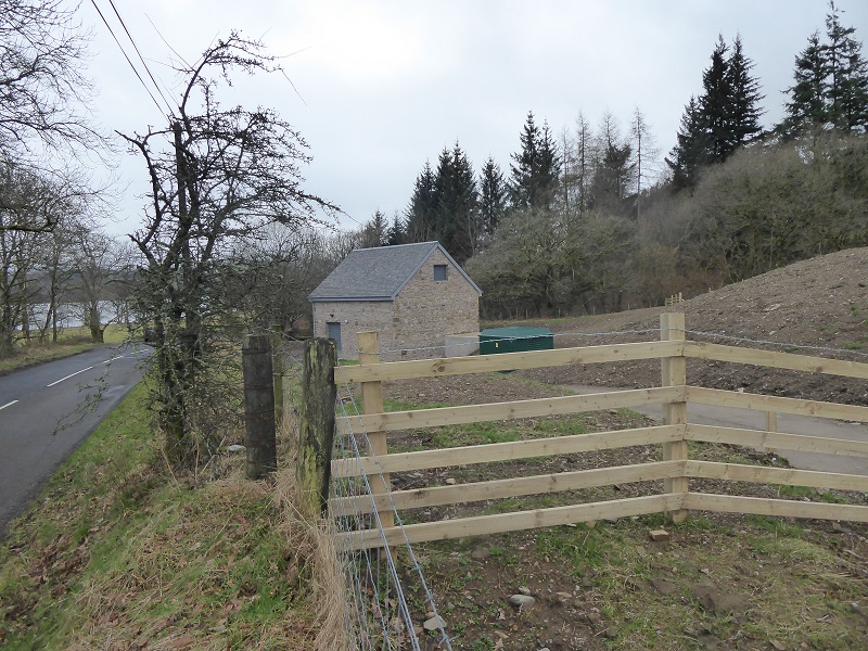
The ground above the pipeline has recovered well – it normally does within forestry. Lower down the powerhouse is well situated and I confess to liking the new cascade from the outfall:
Generally, this is a good hydro scheme with little adverse landscape impact. It should come as no surprise to readers to learn that this is where the LLTNPA take visitors when they want to show off hydro schemes. Stank Glen has the added cachet of being a community run scheme which helps fund a multiplicity of local groups in Callander.
Despite these positives, what sticks out for me is the ugliness around the intake, an opportunity missed. Unfortunately, the LLTNPA lacks basic procedures and mechanisms in quality control that could have made this a truly excellent scheme. The only time they enforce their own Guidance on design is when people complain. Its time people did so here.
Milton Glen
This glen has long been blocked by a dense conifer plantation and consequently rarely visited although most people travelling along the north shore of Loch Venachar will have seen the powerhouse by the road.
There was already a track up beyond the farm to a Scottish Water reservoir and the lower section of the pipeline runs under fields where the vegetation recovers quite quickly. The main adverse landscape impact in the lower half of the scheme is the pipeline bridge:
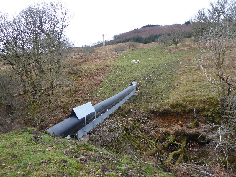
The LLTNPA’s Best Practice Guidance recommends avoiding bridges like this. The delegated officer report which approved the scheme stated “A condition has been imposed (condition 21) requiring further details of the bridge design to ensure that it is sympathetic to its environment and that there are efforts to screen the pipe”. Clearly that has never happened.
Further up the scheme entered the forestry plantation and a new road had to be constructed. This provides an interesting example of innovative design. The LLTNPA required the construction track to be narrowed to 2 metres, except on bends, and to have a central grass strip running down the middle but they also agreed the track should be constructed so that it could be widened in future for forest felling.

The creation of the track through the forest provided an opportunity to re-open Milton Glen for outdoor recreation and could provide the basis for another route up Ben Ledi. Unfortunately, the track ends before the plantation does.

The intake itself is pretty ugly, rip rap bouldering spoils what could have been an attractive pool (contrast with the Stank Glen scheme) and the usual bare concrete and blue pipes contrary to LLTNPA Guidance. Once again evidence of a lack of quality control or resources being devoted to ensure that schemes meet the highest standards.
The cumulative impact of the Ben Ledi hydro schemes
A few years ago I toyed with the idea of ascending Ben Ledi by 50 different routes, experiencing the mountain in the round as it were. I have never seriously tried to do so but, whatever we do recreationally, in land-use terms we need to think about our hills in the round.
Look at a map of Ben Ledi and there are three major burns which collect water as it flows down the hill – the Milton, Casaig and Stank. All three now channel a significant proportion of their water down through hydro pipes. This has consequences, both for the mountain and for the land and people below. Does anyone yet know the impact that reduced water flows in burns will have for the creatures that live in them or migrate through them? And what about the increased speed of run-off of all the water that now goes through the pipes and to a lesser extent down the new tracks? Is anyone in the LLTNPA thinking about compensatory measures, such as removing sheep off the hill which would enable vegetation to recover and hold back water which otherwise adds to the flood risk below? Should a National Park really be agreeing to change the hydrology of all the major burns on one hill without considering the consequences?
Then there is the cumulative impact of new roads on the mountain, about 4km for Gleann Casaig and 1km for Milton Glen. This comes on top of all the other road development around the hill, primarily forestry tracks but also other bits of road like to the Brig O Turk Scottish Water reservoir. The landscape impact of these roads becomes only too obvious each time a section of forest is felled. If anyone should be promoting thinking and debate about a limit to the number of roads in our hills it should be our National Parks but, unlike the Cairngorms National Park Authority, the LLTNPA has not even started to consider this. Instead, each development is used to justify the next: in the case of Milton Glen hydro, for example, the permanent access road was justified in the Officer’s Report because the forest was due to be felled within 2-7 years anyway.
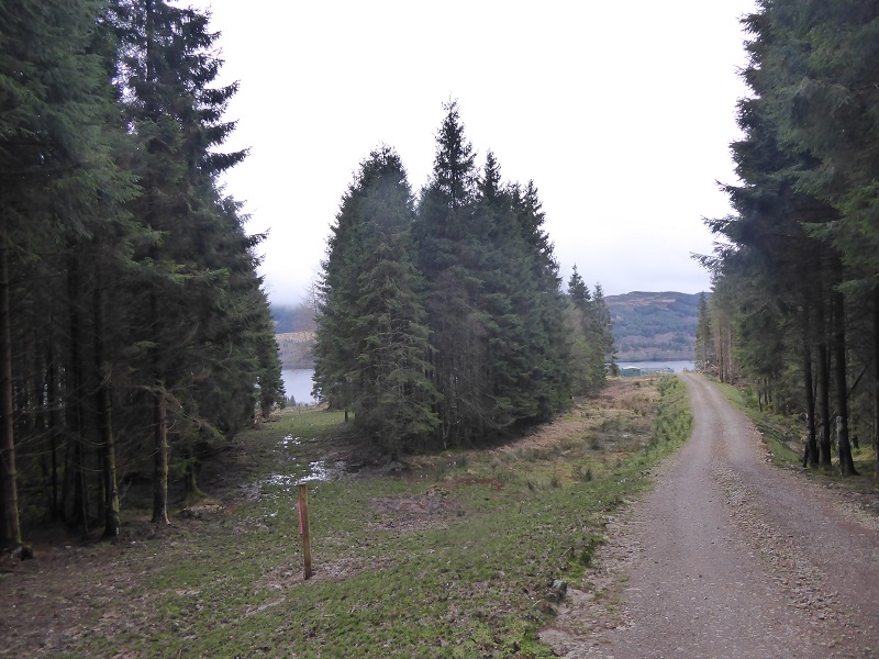
How all these roads fit with the path network is not even on the agenda. A lot of work has been done on paths on the popular circular route over Ben Ledi: Stank Glen (above) and the path up from the “main” car park:

The impact of much of this, in landscape terms, is negligible, has been helped by generally (there are some exceptions) high quality finishing:
The impact of the paths lower down will be reduced further as the native woodland that has been planted around them develops. This is not to say paths have no landscape impact compared to roads:

The new path along the summit ridge is very prominent from viewpoints along the ridge although is unlikely to be visible from further afield. Whatever the arguments about whether the path could have been better aligned and designed, the point is that in terms of the mountain as a whole, the LLTNPA has made no attempt to consider whether or how the new hydro tracks should interface and connect with the path network. Instead, there has been piecemeal development. This has implications for the cumulative impact of access routes on the landscape but also represents opportunities lost.
Look at this another way, what has been the cumulative contribution of these three hydro schemes to Ben Ledi? How much of the money generated is being invested back into the mountain, either to promote its ecological health or to enable people to continue to enjoy it in a sustainable manner?
Run of river hydro development has been driven by landowners and the renewables industry chasing Feed In Tariffs. A case in point is the Milton Glen scheme where the LLTNPA rushed through the original application without a construction track because of pressure to “to determine it before the OFGEM ‘feed in tariff’ deadline of 31 December 2014”. A separate application for the track was then approved in 2015. Its been a wild west out there with no coherent national energy strategy and no coherent land-use planning. Unlike wind farms, where there is a presumption against their development in National Scenic and Wild Land Areas, there is no national policy framework for where hydro schemes might be best located or how many might be acceptable.
The LLTNPA should have been addressing that gap but instead has done the Scottish Government’s bidding and approved as many hydro schemes as possible. In planning terms this has been easy to deliver as all developments are decided by reference to vague and woolly policy statements from the Local Development Plan which can be interpreted any way you want. By contrast, a proper land-use/development plan might have ruled out hydro developments from certain areas (e.g Wild Land Areas) and taken a look at the cumulative impact of development in others (as Planning Authorities are supposed to do with wind farms).
Its time that the LLTNPA took a strategic look at land-use and development within the National Park. Rather than Estate Management Plans, which are its current favoured (but secret) method of influencing land-use, it should be developing plans over much wider areas and engaging the public. The hydro schemes around Ben Ledi provide a good example of why such an approach is needed.

I used the Gleann Casaig hydro access track to gain access to Benvane on New Years day. I had visited the scheme a couple of times since my initial survey and noted that while the track is far too wide than is really necessary the verges were beginning to recover in places. However, because of the track, the farmer is able to gain easy access to the south eastern slopes of Creag na-Airighe to allow his cattle to graze. In fact he has installed a feeding station approximately 400 metres distant from the powerhouse and just off the line of the track. Obviously the cattle congregate around this area and has caused irreparable damage to the track. I also noticed that the lengths of pipe which had been discarded by the contractors have not been removed.
I had a walk Glen Finglas a couple of days ago and was horrified at the noise coming from the hydro power house. It was a pleasant winters day and burns were at a relatively low level. On the way back the high pitched whine could be heard over 1km away at the dam. I measured it at 74dBA 10 metres away from the power house. I had a look at the planning application and came across the following ridiculous noise statement.
7.3 During the operational period of the Development, the sole noise sensitive property with a
potential to be affected is the Ben Ledi Cottage, located approximately 325m south of the
proposed powerhouse location. Interceding between the powerhouse and this property is the
Allt Ghleann Casaig burn and two lines of woodland, both of which would contribute
throughout the year to background noise levels. In addition high background noise levels
throughout winter, autumn and spring are likely due to the wind regime across the site, such
seasons being main generational periods of the Development when water levels are higher.
During the summer months when background levels from the wind regime would be reduced,
similarly the water turbine and resulting noise emissions will be reduced as water levels,
associated with lower rainfall, are reduced.
It seems to say that the noise doesn’t matter because its usually windy and when its not windy it will be summer and there won’t be much noise it has also been assumed that the only people who would notice are the nearby cottage occupiers. The exposed location of the power house at the edge of the loch means that the high pitched whine is audible for a long way across the water and completely spoils the atmosphere of the place on a still day. It would be very easy to rectify this with some sound proofing and baffles. Some trees might have helped as per the planning statement “This effect will be temporary in nature and deciduous tree planting is proposed post construction” but not much sign of these either. I have attached a video here but it does not convey the true effect. https://youtu.be/4_9cvdzX7V4
Hi Kevin, this is the best analysis of the noise impact of hydro schemes I have seen. It adds more evidence to the case that the LLTNPA Board should commission an independent review into the hydro schemes they have approved in the Park which was tasked with making recommendations about the issues the Park should address. It would be very good if you could report this case to the Director of Planning at the Park stuart.mearns@lochlomond-trossachs.org and ask him to take action to address the issue as you suggest. Nick
Love the comments about a complete lack of thought from our planners and thinkers, there must be an accountable system brought into play . The public fund these regulators and then pay again to right the wrongs ,madness.