Backed by a host of environmental NGOs, the Greens have secured a debate in the Scottish Parliament this week about the Nature Emergency. With the A83 at the Rest and Be Thankful still closed, it seems to be a good time to highlight further the challenges posed by landslips (see here for Glen Falloch and here for the Trossachs). While a natural phenomenon, the frequency, size and destructive potential of landslips appears to be increasing significantly due to both the climate emergency and the the degraded state of the natural environment in Scotland, the nature emergency.
Loch Katrine
In September, 13 months after the extreme rainfall which triggered landslips in Glen Falloch and Strathard, I managed to take a closer look at the damage they had caused at the head of Glen Gyle. This has now been cordoned off from the public for almost a year. On my first attempt to visit I had been turned back on the track from Stronachlachar by a charming security guard from Maryhill, but this time arrived courtesy of boat. I should have guessed that in twelve months the trail of many of the landslips would have greened over, with vegetation being given a boost by a new spread of mineral soil, so that most are now scarcely visible. We should not forget what happened.
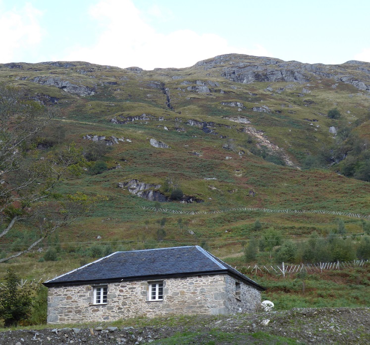
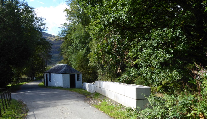
While the area around has now been restored by Scottish Water, debris from the landslip on this hillside piled up behind the house to its eaves. It must have been extremely frightening for the people staying there. Had the landslip moved fast like an avalanche, it would have probably destroyed the house. The debris moved slowly, however, giving time for people to escape.
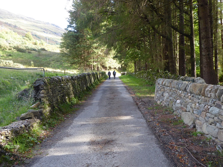
Though slow, the landslip was powerful enough to carry away two dry stane dykes.
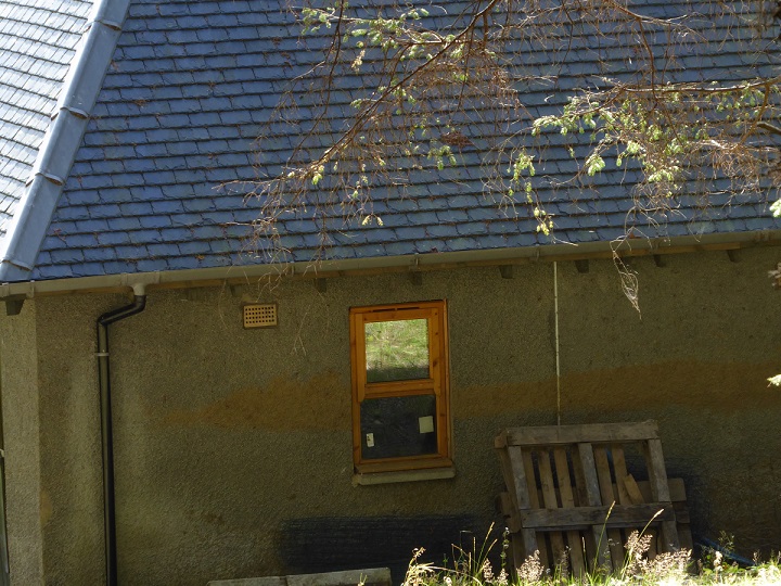
All the people staying at Glen Gyle had to take refuge in Rob Roy’s old house, the only building unaffected. I understand the other buildings are unlikely ever to be used again – they have become uninsurable – and Scottish Water has been negotiating with their owners to buy them up. The threat of landslips has made most of Glengyle too dangerous to live.
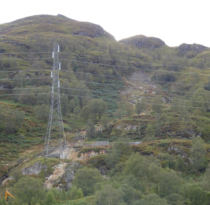
Had the landslips further round towards Stronachlachar actually toppled the powerline, that would have had a major impact on the national grid and we would have heard a lot more about it. As it is, it has taken more than a year to fix the damaged tower.
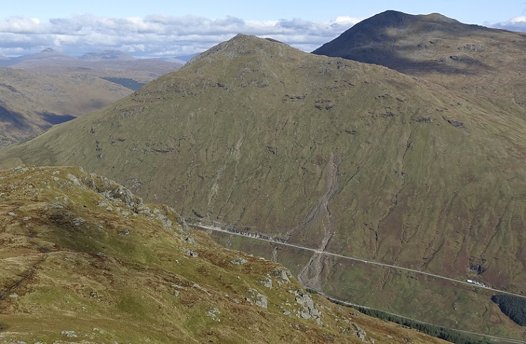
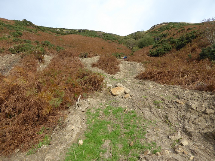
In both landslips, what struck me was how small the scar on the hillside appeared compared to the area of ground affected. Just think of the amount of material and the damage it could do if the whole hillside went. Unlikely around Loch Katrine perhaps, because of the angle of the slope and because the hillsides are broken up with rocky outcrops and trees. But Beinn Luibhean, above the Rest and Be Thankful (top photo), is a different matter.
The risks posed by landslips are a Scotland-wide problem
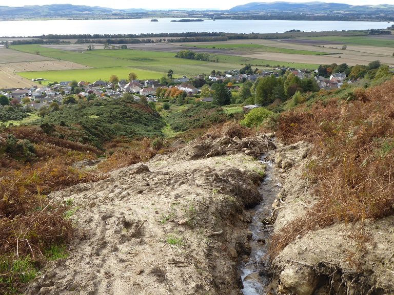
One year after Glengyle was cut off by landslips, another extreme rain event, this time in the east of Scotland was responsible for derailing a train south of Aberdeen, killing the driver. That same rain event triggered a series of landslips on the western escarpment of the Lomond Hills overlooking Loch Leven. In October, I went to have a look at one.
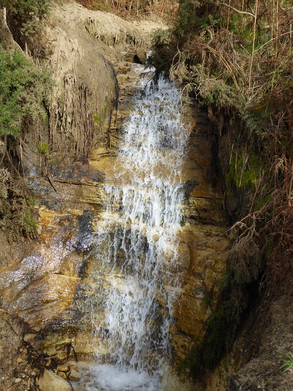 It appeared to have been triggered by the force of water down a small burn cutting away part of the bank on some rock slabs.
Below the trees, the landslip gathered a significant amount of material and spread out like an avalanche. An interesting question is whether trees lower down might have limited its progress. In this case the landslip followed the line of the burn and its banks, so even if it had been much bigger and reached the village, it would probably have flowed through it.
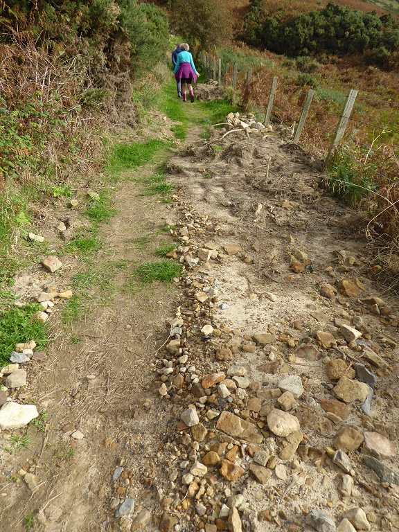
I wouldn’t, however, have liked to have been on the footpath.
The risk from landslips and what needs to be done
The evidence from the last year and a half shows that landslips now pose a significant risk to human life as well as to property, electricity infrastructure, roads and railway lines. Personally, I would now think three times before driving through the Rest and Be Thankful on the Old Military Rd in the heavy rain. Thankfully, Transport Scotland appears to be getting their act together and closing that route when the forecast is bad, but what about the risks elsewhere?
Unfortunately to date our Public Authorities have taken almost no interest in landslips, why they are happening or the risks they pose. The Loch Lomond and Trossachs National Park is a landslip hotspot, but so far the Park Authority, which could have been showing a lead, has remained totally silent. The Scottish Environment Protection Agency, the authority best placed to raise the alarm across Scotland, is focussed lower down on flooding some of which results from the type of extreme rainfall events that precipitate landslips. The British Geological Survey maps landslips where it can – a group of students had been lined up to report on the Loch Katrine landslips until Covid intervened – but is not resourced and has no responsibility to do so. Transport Scotland, slow to appreciate the dangers at the Rest and Be Thankful, doesn’t appear to have started thinking about other roads. The only public authority to respond so far appears to be Network Rail which, following the Aberdeen accident, has committed to review the safety of railway lines across Scotland. Even where it identifies risks, what Network Rail can do will be limited unless it is given powers to take action on the surrounding land.
Arising from this lack of interest, there is no national methodology for assessing landslip risks. In a mountainous country like Scotland that seems extraordinary. To my mind government should, as an integral part of our response to the climate and nature emergencies, be assessing all slopes above settlements and key infrastructure for landscape risk. It will be only able to do this if it assembles and pays for expertise from a range of disciplines: geomorphologists, soil scientists, hydrologists, foresters, ecologists etc.
Alongside understanding the risks, we need to develop nature based as well as civil engineering solutions to mitigate them.
Allowing sheep to continue to graze the slopes above the Rest and Be Thankful as late as 2019 was to my mind criminal negligence. Over much of the uplands in Scotland high numbers of Red Deer are helping to break up peat bogs, that soak up water, and preventing woodland regeneration. After viewing the landslips in Strathard in 2019 I wrote to Jo O’Hara, then head of Scottish Forestry, about what t Forest and Land Scotland, who own much of the land in the area, were doing to address the problem. Although she rejected my suggestion of an inquiry (I believe one is still needed), the reply (see here) was far more informative than anything I have ever received from the LLTNPA:
“FLS (Forest and Land Scotland) have been culling significant numbers of deer in this catchment and will continue to do so. However, a consequence is that deer from surrounding (privately-owned) properties move across the ownership boundary to occupy the land made available by the culling. Most of these properties are members of the Balquidder Deer Management Group (as is FLS), and many also rely on income generated by deer to support their land management activities. Over a number of years, FLS has been collaborating with the group, setting cull levels in Katrine at a level which reduces the local deer population but still leaves a population of sufficient size to satisfy other
landowners. In return, FLS has expected, and encouraged, these landowners to cull significant
numbers of deer on their land as part of a landscape-scale approach.
As yet, the cull levels required for the sustainable development of native woodland across the
catchment have not been achieved. As a consequence, FLS now intends to implement further
significant increases to the cull on the land that it manages in Katrine. These increases will be
implemented starting this year, with the cull level being set using data on the population from
helicopter counts.”
In effect, Forest and Land Scotland’s attempts to persuade private landowners to reduce deer numbers voluntarily have failed. The deer keep flowing onto the publicly owned land around Loch Katrine preventing woodland re-generation in an area which forms part of the Greater Trossachs National Nature Reserve and Forest and was designated to do just that, .
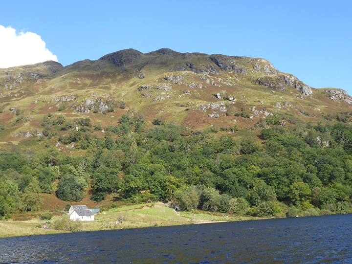
Trees won’t in themselves prevent landslips, as the photos here and in previous posts show. There are hints though (second photo) that woodland may help contain landslips. We know too that woodland helps hold back water which is what triggers most landslips in Scotland. The development of a scrub zone would have slowed and limited the volume of water flowing down the hill, potentially reducing the number of landslips triggered above the current tree line and in woodland on the lower slopes. That is not possible at present at Loch Katrine, Glen Falloch or many other parts of upland Scotland due to high deer numbers.
Landslips should provide further evidence, as if more were required, as to why it would be in the public interest for there to be compulsory reductions in deer numbers in Scotland as part of our response to the nature emergency.
I don’t believe trees are the answer – the Stonehaven train accident landslip happened in a heavily wooded steep valley – and much of the soil above the A83 would struggle to support much tree growth.
Last month I took part in a clear-up after the storm in the south of France that killed nine with nine still missing. It saw half a tonne of rain fall on every 1m2 of land in the high valleys.
The vast bulk of the clear-up on the beaches 60km away was timber. We’re talking complete tree trunks. Timber was piled along 10km of coast, reaching 2m high and 15m deep. The navy reported a 3km ‘raft’ of timber about 15m wide out at sea.
Much of the wood was larch, which is usually shallow-rooted, and at risk in heavy rain.
I’d love to think Scots pine could be different and that young trees could help stabilise a slop… but this research suggests otherwise, at least for the A83 https://blogs.agu.org/landslideblog/2020/01/31/trees/
Ken, this is very interesting. I have a question, where did all the timber come from? The fact that water rushes off our burnt grouse moors, floods say into the Dee and then destroys trees along the river does not appear to me to be an argument against trees as such. More trees in the uplands might have reduced the flow and saved the trees lower down. Nick
The timber came from valley sides and flood plains along the three affected valleys. Such as here https://www.laprovence.com/actu/en-direct/6132801/video-inondations-dans-les-alpes-maritimes-sur-la-route-de-saint-martin-vesubie.html
That article only suggests that trees may not help on a VERY steep slope, but they are likely to help on slopes up to 35°, which is pretty steep. By my reckoning. the slope above R&BT rises about 600m in 1000m, so about 30° , is that about right?
I heard a forester speaking about landslip protection on scree slopes in Norway yesterday, who said aspen and birch in particular offered protection on scree slopes.
Thanks for this excellent article. Land management is such an important issue affecting the climate; it needs to be at the top of the agenda.
Regarding the train derailment, please remember the conductor and passenger who also died.
The ‘Interim report to the Secretary of State for Transport following the derailment at Carmont, near Stonehaven’ made much of human induced climate change ‘events’, stating: ‘These factors increase deterioration of our earthworks and put pressure on drainage systems, increasing the likelihood of critical coping thresholds being exceeded, prompting increased levels of intervention.’ Therein lies one of our major issues, which is believing we can always engineer our way out of the problem of landslips. I do not believe we can. As we have seen from the Rest, we are really just playing catch-up. I did note from photos of the derailment scene that although the cutting is wooded, it is only quite a narrow belt of trees and the terrain above the treeline is devoid of cover.
https://www.bbc.co.uk/news/uk-scotland-north-east-orkney-shetland-54522370
http://news.bbc.co.uk/1/hi/scotland/north_east/8536733.stm
Stonehaven seafront has a huge quantity of driftwood, many substantial tree trunks and other heavy timber lies in deep deposits at the high water mark. Locals have formed pyramids of the wood only as an art form as burning is not advised.
https://twitter.com/pawsonplastic/status/1317477245640970243/photo/2
Here are two coastal landslides. and
Your blog on slope stability is timeous. The downpours of 2014 lead, not only to spectacular floods, but also to quite dramatic erosion gullies etc over much of the highlands. I observed them when setting out in the hills in the NW in particular. Climate change is leading to relatively small incremental increases in temperature, rainfall etc but small increases in average levels lead to much greater increases in frequencies of extreme events like heavy downpours.
I recall driving over the Slocht enroute to meetings in Inverness. Looking at the slopes around the summit, overgrazed and “burnt to buggery” as the saying goes and I would wonder, ”When will that lot will go?” And one day, after heavy rain, they did. “Surprise” said the road department – Really? Not unless you were blind! Grazing intensities can be part of reducing frequencies of landslips but even obvious risk areas are ignored. It is astonishing that sheep were permitted to graze the Rest-and Be Thankful after the problems there.
Ken casts doubt of the value of treeplanting to control landslips but this is a very old and well tested approach in the Alps. I have had study tours to look at land management in the Swiss Alps. In the ALPS,60% of all the forests are “Protection Forests” whose triple functions are protection from avalanches, prevent soil erosion, and stabilise slopes. It is impossible to live in the Alps without them and all communities, key roads etc have their protection forests – all strictly protected and very carefully managed to conserve their stability.
The Swiss also launched a programme of physically stabilizing slopes in the 1980s and I was taken to see some of sites during another study tour there. The guy in charge then wrote a textbook on the subject drawing on all that experience. The Canadians thought it so important they had it translated into English. Presumably things have moved on since then but whether this is all drawn by on engineers in Scotland I would not know.
However, the whole issue is not new in the UK. When I was training the Environment Agency on public consultation in the Lake District, the guy organizing the course told me of his project. Using Lottery Money, he had got the whole of the Lake District surveyed for vulnerable slopes and those identified were now all being planted up. Is it perhaps time to have the Highlands similarly treated?
Network Rail has completed embankment and drainage work at Slochd Mor and Slochd Beag between Perth and Inverness on the Highland Mainline. The project, is to help protect against landslips and rockfall and also address a known flooding risk area which has caused delay and cancellation to passenger journeys twice in the last twelve months. It represents an investment of £4.8 million to protect the infrastructure. Work has seen installation of a new piped drainage system and earth-bunds, as well as concrete lined ditches to manage the flow of water away from the railway to culverts and natural water courses.
The project, was delivered over two kilometres of railway and work began at Slochd in September 2019 and has targeted known areas of embankment with a history of instability and prone to rock-fall and flooding. over 11,000 tonnes of stone was used to regrade more than 400 metres of railway embankment which is 14 metres high in sections. In addition, more than 840 metres of concrete lined drainage channels have been created and rock-netting has been installed where required. 110 metres of ballast retention has also been added to support the crest at the top of the embankments and to provide a new secure cable troughing route on the side of the line.
Transport Scotland has invested in steel netting much of the A9 rock cutting embankments at the Slochd Mor to try to prevent the water derived rockfall blocking culverts and diverting runoff onto to the main carriage way which occurred on 31 July 2002. Sheep numbers have fallen considerably on the higher slopes giving rise to some regeneration and some tree planting has taken place although muir burn continues. I recall being told that modern construction methods fracture rock more deeply making cutting faces less stable than when Victorian navvies cut though with black powder and picks – but maybe that is an urban myth.
Climate change is indeed an expensive business.
The known phenomenon of peat slides are well illustrated in this video from last week in Ireland which show entire erect groups of trees on a peat base moving slowly down a very modest slope like Birnam Wood in Macbeth. https://www.irishnews.com/news/republicofirelandnews/2020/11/16/news/concerns-over-massive-peat-slide-at-co-donegal-bog-2130570/
New Zealand has experience in landslip mediation and prevention which also includes tree planting. NZ has experience in stabilising a large scree etc landslip above the Roxburgh high dam which threatened to slip into the reservoir. Thus far it has been successful.
There will be differences but also principles. An awful lot of work was done above the road and rail lines to stabilise the slopes after the Kaikoura earthquake which Scotland can learn from.
Interestingly, Japan suffers greatly from landslides and has had a number of deadly disasters related to them. They take them very seriously – to the extent that there’s actually a national “landslide society” that publishes a regular journal on the subject (https://japan.landslide-soc.org/), and sponsors an international “slope disaster” forum. They investigate and report on major landslide disasters and their reports are publicly available on their web site. With more than 1,000 reported landslides a year the Japanese have advanced plans for dealing with them – as reported here https://www.nippon.com/en/features/h00275/ and resulting in tightened up planning controls and support for residents to relocate from “red” zones.
Cory Morningstar fb is good at this. @elleprovocateur @CompromisedNGOs and Wrongkindofgreen I remember a WDC meet on R Leven Flood Defence Scheme/that never happened. It was meant to complement the R Leven Canal Plans/that never happened. They had a big frieze up in the main Council Chambers. One of the officers said to me, “What are you worried about? You’ll be dead when that happens.” Then the banks blew up. I mean it’s just purely wild speculation and day dreaming on my part….but maybe if we spent less time and money on trying to kill all the people the US says we should, we could get a few things sorted properly round here. This US Biden/Harris duo of Democrats are “Forever War.” That’s about the biggest contributor to climate change and environmental degradation there is. A lot of these “greens,” NGOs/charities, “aid agencies,” stakeholders/interested parties operate with strings attached and as fronts for ruling class self enrichment and empowerment. Public/private funding means, stay out of politics and don’t mention the wars. So, they are compromised and won’t rock the boat…or they’re actively involved in spreading disinformation and counter-intelligence.
Uk just approved an increase off £16 billion weapons spending over next four years perhaps they could flatten the mountains with bombs
The problem at the A83 is thin soil lying over steeply sloping rock planes and high rainfall lubricatiing the interface between them and helping the soil to slip off down the hillside and across the road. Planting trees will just add tree trunks and roots to the rock and soil debris that will slide downhill. The solution for the road is obvious and can be seen in almost every Alpine valley across Europe – build an avalanche gallery over the road so the unstoppable debris simply slides over the top and comes to a natural halt at the valley floor. Nets, gulleys and trees are just a waste of time and money. Unfortunately the Scottish authorities seems to be unable to look further than their own back yard when looking for solutions to road infrastructure, and other,issues.
The problem with the A83 is that some moron decided to slice a road directly across an unstable slope.
The next problem is that they refuse to build a tunnel. Nevermind the avalanche sheds. There are far quieter roads across the continent which justified miles of tunneling, but we can’t do it in the richest country in Europe.
You’d almost think some people are deliberately handicapping our country. Possibly.
It is certainly the case that the Scottish hills are already cut through with tunnels – mainly hydro. In 1926, my father travelled on an electric train through the 3m wide tunnel from Loch Treig under the Grey Corries and Ben Nevis to where the pipes emerge above the smelter. I believe the tunnel is still dewatered every five years for inspection. But even a lay person with out specialist geological or engineering knowledge reading the attached analysis of the tunnel collapse at Glendoe in 2012 and subsequent court case can see tunnelling the A83 at the RBT for any distance would be a very complex business. https://link.springer.com/article/10.1007/s00603-019-01812-w
It might be complex but they do it in Norway that has a very similar geology to Scotland and in terms of the Loch Treig tunnel that was I understand once the longest tunnel in the world, so at one time Scotland had the expertise
New Zealand has driven rail and hydro tunnels in a region prone to huge earthquakes. Many of the NZ hillsides are rubble piles. It is possible. You drill a small distance then install concrete interlocking panels in the space. That was how they did the Channel Tunnel. The technology exists.