Background to the core path network and the consultation
While the focus of the Land Reform (Scotland) Act 2003 was rightly on securing general rights of access, the recreational organisations involved recognised that the biggest challenge for the future would be how to extend Scotland’s poor path network. Scotland at the time was far ahead of England in allowing people the freedom to roam, but it was way behind in terms of path provision. The creation of a legal requirement that the new Access Authorities, including National Parks, produce plans for core paths was intended to remedy this deficiency. It was acknowledged that Scotland could not do this all in one go, hence the statutory requirement for Access Authorities to conduct formal reviews of their core path plans. The vision was that the core path network could and should be extended over time.
Unfortunately, 15 years later that vision is far from being realised, with all the consequences that has for health and well-being. The basic reasons for this are that our Public Authorities do not allocate funds to footpath creation and maintenance (cycle paths have been much better funded through Scottish Government funding Sustrans) and Access Authorities have insufficient powers to create new paths/routes easily (e.g its taken years for the Cairngorms National Park Authority to develop the Speyside Way). Our two National Parks should have a key role here in terms of demonstrating how these issues can be tackled and what a comprehensive path network would look like.
Unfortunately, the powers that be in the LLTNPA appear to lack vision or any ambition for the core path network in the National Park:
3. Conclusion
The comprehensive public consultation and path selection process conducted 13.1.through 2006 to 2010 has left a positive, lasting legacy of a Core Paths Plan which is widely accepted and respected throughout the National Park area. Consequently there are a limited number of suggested amendments for review, reflecting the quality of the work done previously and celebrates some exceptional new paths constructed in the years since which enhance the local and strategic networks.
(extract from Board Paper which approved the consultation process in September 2018)
In short, the claim is the LLTNPA did all they really needed to do 10 years ago. This post evaluates that claim against path provision on the west side of Loch Lomond. It follows my first post (see here) on the core path consultation, which focussed on the area around Ben Ledi. It argued the the criteria the LLTNPA had developed to select core paths was inadequate and this post will add to the evidence for that.
The Luss Hills – a black hole in the path network?
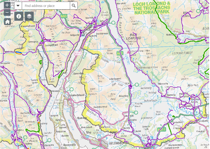
The most striking thing about this map is the large area in the middle which has not a single core path in it. The Luss Hills, which are the nearest and most accessible hills in the National Park for people living in the Clyde conurbation, form a sort of black hole in the core path network (along with a similar path free area to the east of Loch Lomond in the Lochard Forest)
There are historical reasons for this. The military were for many years not keen to encourage people anywhere near their weapons depots while I am told that a former chair of the former joint Committee for Loch Lomond saw this as their local patch and was not keen to encourage the public. While the views of the military have changed, as is evidenced by the creation of the Three Lochs Way which runs along Loch Long, it would be interesting to know (I have asked) whether Luss Estates and its farming tenants supported the creation of core paths in this area. Landowner support is one of the ten criteria the LLTNPA use to evaluate whether a path should be added to the core path network. Without it, its almost impossible for any path into our hills to score sufficient points (which is why the LLTNPA Board needs to change the criteria).
The National Park’s stated aims, however, are that paths should provide “reasonable access throughout the National Park” and that paths should “allow both residents and visitors to fully explore the National Park”. If you are resident or stop off at Luss or Inverbeg, however, there are no core paths into the hills which deliver these aims . Instead, the message seems to be “no easy access here”. This is extremely shortsighted because the Luss Hills are not only accessible and relatively well served by public transport, they can offer a stunning recreational experience, with all the benefits that brings to people.
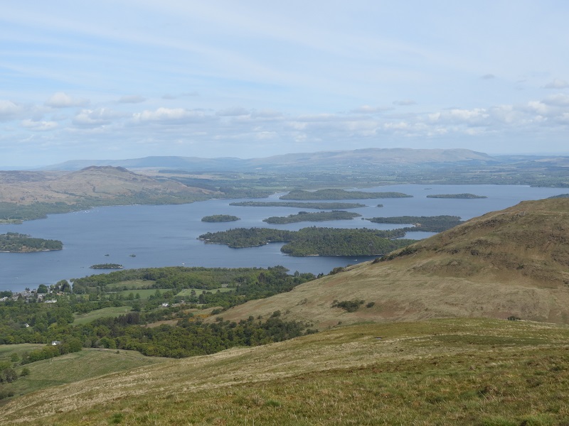
Giving out the message that this is a great place to walk and encouraging a few more people inland would also help spread visitor pressure away from the loch shores.
LLTNPA staff on the ground have been trying to do their bit to improve the path network locally. They have resolved the issues which led to the route recommended by landowners at Auchengavin being obstructed by a deer fence (see here) and have also signposted other paths:
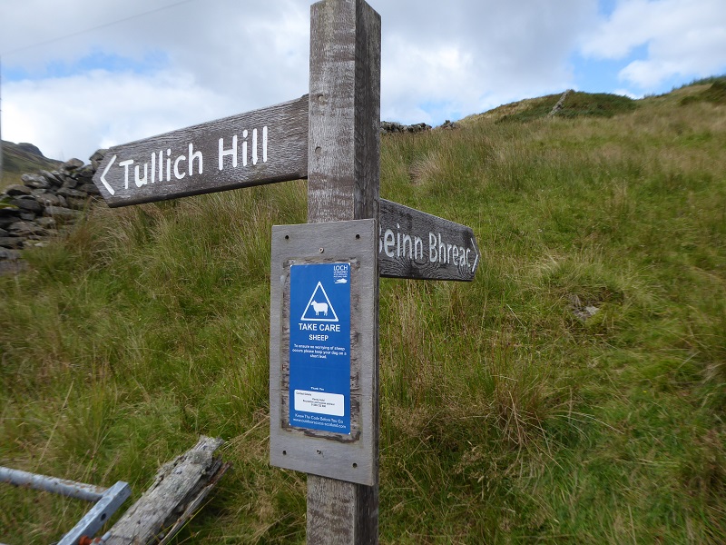
Why then aren’t some of these paths being added to the core path network to enable people to enjoy the National Park more fully?
The second thing that is striking about the map above is that it ONLY shows core paths WITHIN the National Park so the Three Lochs Way, for example, appears to terminate at the National Park boundary. That fails to allow people to see the core path network as a whole and the potential for neighbouring Access Authorities to join up their path network. It undermines one of the criteria adopted by the LLTNPA to evaluate paths
- Provides a link (or part of a link), between settlements including cross boundary
How can people make the arguments for path links across Access Authorities if they cannot see what’s there?
Arrochar – a missed opportunity
The core path network around Arrochar and Tarbet is far more extensive than that further south. This is in no small part due to the efforts of volunteers who succeeded in getting the Three Lochs Way designated as a core path and have been actively involved in developing paths around the communities. It raises the question about why there is not a similar density of core paths around other communities in the National Park like Luss?
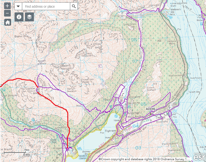
What’s striking about the path network, however, is how limited it is when it comes to the hills. The Arrochar Alps are one of the most popular places for hillwalking near Glasgow and, apart from Ben Lomond, the Cobbler is probably the single most visited hill in the National Park. Yet only the most popular route up and over the Cobbler is marked. The contrast with the Lake District, where there are multiple paths up hills which helps to disperse visitors and spread the impacts of feet, is striking. If the Cobbler was in the Lakes there would be a route marked from Glen Croe facilitating access to the mountain from three sides. Instead of expanding, however, the path network on the Cobbler is shrinking. Historically and in the days of the campsite, many people walked up the Cobbler from Ardgarten, but the Forestry Commission has allowed this route to become blocked by forestry. The core paths plan should be providing the basis of access to our hills but is failing to do so.
For anyone who believes this does not matter, consider the case of Cruach Tairbeart, the small hill north east of Arrochar overlooking Loch Lomond. Its a stunning viewpoint, accessible from the station, and is just the sort of medium length walk that the National Park should be promoting to people who do not have experience of the higher hills and want to try a hill for the first time. Yet, the way up is not at all obvious and, even if you are not put off by all the unhelpful forestry signs which have served to deter access here for the last couple of years (see here), you are likely as not to end up failing to find the best route. The creation of a core path up this hill would not just help the public, it would focus minds within the Forestry Commission about how they could improve how they manage access here.
Indeed, responsibility for much of the lack of ambition in the core paths plan lies as much with the Forestry Commission as with the National Park. Forest Enterprise Scotland’s remit is not just to produce trees but to promote public enjoyment of the forest estate. Its also by far the largest landowner in the National Park. Why then is it doing so little to deliver the sort of comprehensive path network that our National Parks should be aspiring to? Click on any part of the excellent interactive map in the core path consultation (see here), take a look at the areas covered in forest and you will see what I mean.
Its worse than that though, the Forestry Commission has been one of the main beneficiaries of the Mountains for People project (see here) which is delivering much needed path work in our two National Parks:
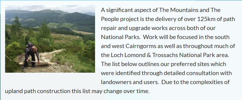
Note how the paths were selected after detailed consultation. They include seven paths in the Arrochar Alps:
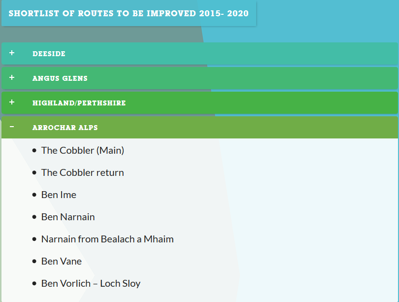
Despite the obvious importance of all these paths to outdoor recreation, only the core path over the Cobbler has been included in the core path network. If this does not represent a complete failure in joined up thinking I cannot think what does.
More failures in joined up thinking at Inveruglas
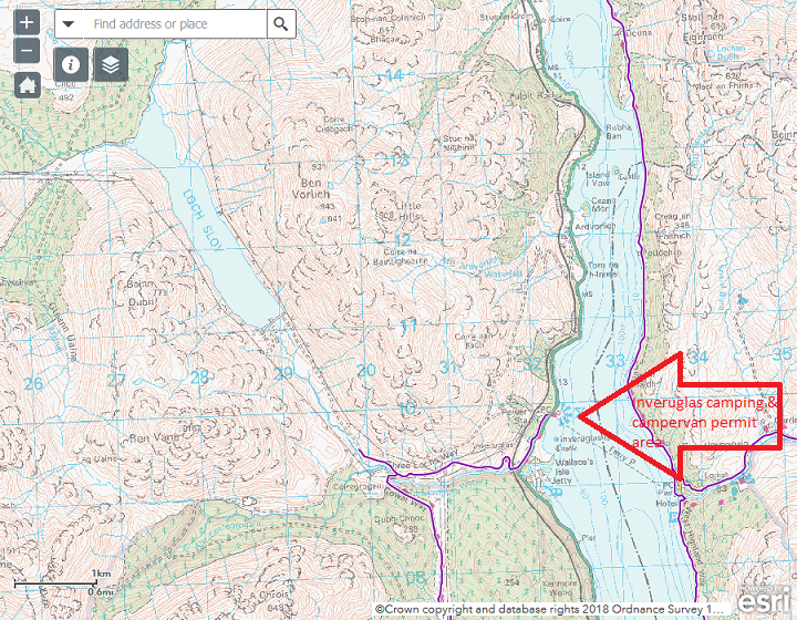
North of Inveruglas, another big hole appears in the core path network. Just why the short dog-leg off the Cowal Way meets the core path criteria, but the road above to the Loch Sloy dam does not, is not clear. It makes no sense. Its a popular walk to a striking construction of considerable historic interest.
Consider that in the context of the Inveruglas visitor centre and camping management zone. The LLTNPA are promoting this, both as a stop off point on the scenic routes initiative, and as a place to stay overnight for campers and campervanners. Yet if it wasn’t for the efforts of volunteers to get the Cowal Way designated as a core path, there would be NO core paths here. That is a lost opportunity. The Park should be aspiring to create a network of paths for people to walk around all the areas they promote. Unfortunately there appears to be a complete a lack of join up between the core paths plan and the Park’s other Visitor Experience initiatives. I suspect this has been made worse by the Park’s abandonment of the Visitor Management Plan approach it had started to develop for the Trossachs and East Loch Lomond.
The most serious omission in this map (and the one above), however, is the lack of any core path along the shore of Loch Lomond north of Tarbet. This gap means the core path network on the west side of Loch Lomond is cut in two (there is no core path up Glen Kinglass on the western boundary of the National Park either). Now, I appreciate there is no off road path at present and this section of the A82 is dangerous for pedestrians but its used by cyclists and forms the only feasible link north. One of the strategic aspiration of the National Park should be the creation of an off road path along the shore of Loch Lomond between Tarbet and Inverarnan. The proposed A82 upgrade (see here), which will cost £ millions, provides the perfect opportunity to do so and would cost pennies compared to the total budget. The trouble is Transport Scotland wants to build the new road right along the edge of the loch shore, destroying the landscape and the ability of the people to enjoy it. A core path would get in the way of their doing this. That, I believe, explains the Park’s silence.
What needs to happen
While creating new paths costs money, designating existing paths costs very little:
“A path having core path status brings no additional duties upon the National Park Authority however it does provide additional powers to do anything considered appropriate to maintain the path, keep it free from obstruction or encroachment, and provide the public with directions through signage and promotion”. (Extract from Board Report)
What’s extraordinary about the Park’s core path plan review is not so much that it fails to address the missing links, which in a sense is understandable as it would require more resources, but that it fails to designate well used existing paths, even when considerable amounts of money have been spent on them. That, I contend, shows there is something very wrong with the criteria the LLTNPA have adopted to evaluate these paths:
- Is identified by the community as a priority
- Provides for a specific recreational use, as a primary use
- Provides enjoyment of the Parks special qualities
- Promoted for visitors and tourism linked activity and contributes to economic linked benefits
- Provides useable links with the public transport network
- Provides a functional route/link
- Provides a link (or part of a link), between settlements including cross boundary
- Provides a short route option close to or within settlements or visitor hubs/destinations
- Forms a key link (or part of) to a wider network of paths/routes or strategic longer distance routes
- Balances landowners interests with exercising access rights
The result, as evident by the proposals for the West side of Loch Lomond, is that the proposed core path plan fails to meet the Park’s own requirement that the core path network should “provide sufficient access throughout the National Park area”. For the LLTNPA to change the criteria will need people to respond to the consultation with examples of why the proposed core path network is insufficient and to call on the LLTNPA to think again and have more ambition. You can respond here.

4 Comments on “The LLTNPA core path plan and West Loch Lomond – a failure in ambition”