On 10th July Mitie, acting on behalf of Three, who are working for Digital Mobile Spectrum Ltd, who report to the Big Four mobile operators which include Three submitted a planning application to erect a 22.5m telecommunications mast by Ryvoan bothy (see here for planning papers). A week earlier David Craig explained on parkswatch (see here) the background to proposal, the associated planning application for a feeder mast by the ski road in Glenmore and why neither mast was sensible use of public money.
Since David Craig’s post there has been the General Election, Peter Kyle has been appointed as the new Secretary of State of the UK Dept for Science, Innovation and Technology, and the chair of Building Digital UK (BDUK), Peter Blagden, who oversaw the Shared Rural Network programme responsible for the rash of masts in wild and unspoiled areas, has resigned (see here). There is no indication as yet, however, that the new UK Govt appreciates that spending £500m on removing 4G “Total Not Spots” is a total waste of public money and could be far better spent. David Craig and his brother Rober have set out the evidence for this in a series of posts (see here, here, here, here and here). If you have the time please consider writing to your MP to alert them to the failings of the SRN programme and asking them to contact Peter Kyle requesting he instigates an immediate review.
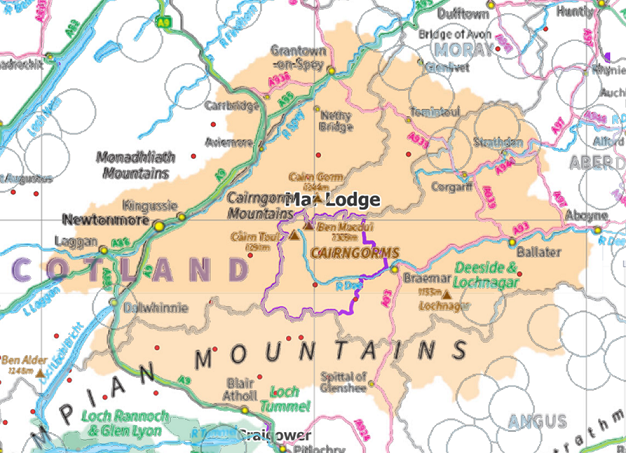
The Cairngorms National Park Authority and the Shared Rural Network programme
To date the CNPA has given no consideration to the implications of the Shared Rural Network programme for its statutory aims. Some months ago I wrote to them suggesting that given the number of proposed masts in the National Park, it would be appropriate for their board to develop overall guidance for both developers and staff. I was told this would not be appropriate because all board members sit on the planning committee, the implication being that any guidance from the board might be seen to prejudice the quasi-judicial application process.
I replied to say I thought this was nonsense, issuing guidance is not the same as taking a decision on applications. I also pointed out the CNPA board had responded to the steady flow of planning applications from HIE at Cairn Gorm by asking them to produce a masterplan for the area to enable the CNPA to better understand how individual applications related to each other and contributed to the aims of the National Park. There is no reason why the CNPA should not ask the SRN to do the same for telecommunications masts, together with an explanation of how the overall plan was designed to take account of the National Park’s special qualities and the protected areas within it.
Instead of taking a strategic approach to the planning applications that have been submitted for the area covered by the National Park, the CNPA has in most cases failed to use its call in powers and left the decisions to the local authority in whose area the mast would be located:
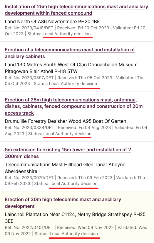
Another example considered in detail by parkswatch was the proposed mast on Creag Dhu by Newtonmore (see here) and (here) which, as George Allan explained (see here), was then rejected by Highland Council as being contrary to both the CNPA’s Local Development Plan and National Planning Framework 4. This makes it all the more extraordinary that CNPA officers decided this mast did not have implications for the statutory aims of the National Park. Until staff call in an application there is no locus for the board and this makes it all the more important that the CNPA has in place clear guidance about when applications for masts will be called-in and why.
Of the planning applications for masts that the CNPA has called in to date, most have been withdrawn by the developer before any report was prepared by planning staff: Luibeg on the Mar Lodge Estate (see here); Creag Sroine at the north of Glen Feshie (2023/0083/DET) ; and recently that proposed for above Red Craig in Glen Clova (2023/0274/DET). As a consequence, there is no precedent to show what how CNPA planning staff are likely to handle the mast applications at Ryvoan and Glenmore or what recommendations they are likely to make to their board. Every reason therefore for the public to put as much pressure on the CNPA as possible with this applications, its important not just for the special area that is Ryvoan but all the other special places in the National Park.
The application, the landscape and wildlife
The proposed mast is located 400m north of Ryvoan bothy just off the existing track which connects Glen More and Abernethy:
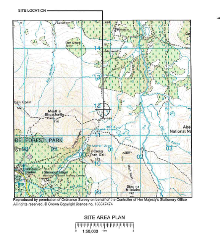
The proposed location is just outside the Cairngorms Wild Land Area (WLA) and the Cairngorms National Scenic Area (NSA) whose northern boundary runs by Ryvoan bothy. Locating masts in the WLA or NSA, particularly the latter where telecommunications masts lose their permitted development state and require full planning permission, would have created further hurdles to getting the mast through the planning system.
The proposed mast, however, is in a prominent position and being 22.5m high will clearly affect both the qualities of the WLA and the NSA.
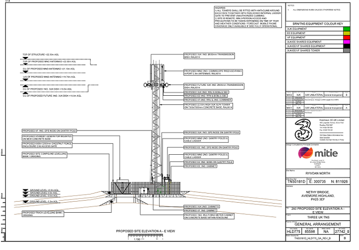
This is significant because no Landscape Visual Impact Assessment has been provided with the application and Mitie has made no attempt to assess objectively its impact on wild land or the landscape.
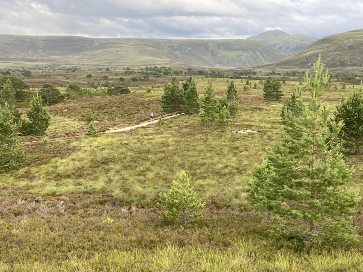
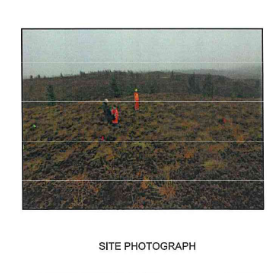
The two photos Mitie has included in the application were taken in poor weather conditions:
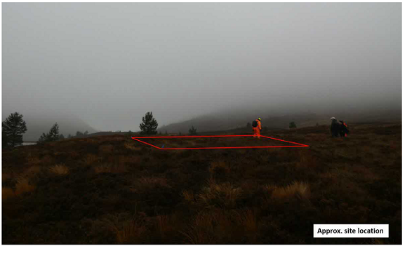
and the sceptical might conclude they were chosen to reveal as little as possible about the landscape impact:
While saying as little as possible about the visual impact of the mast, there is an acknowledgement in the application that it will be an eyesore out of character with the surrounding landscape:
“Furthermore, in order to reduce contrast between the proposed development and the surrounding
landscape, we would propose a to colour the lattice mast and associated ground-based equipment Sepia Brown (RAL8014).”
If successful that might result in more rare birds flying into it! While not in an NSA, all the land around Ryvoan is designated a Special Protection Area for birds and as a consequence the mast requires full planning permission (the proposed location lies with the Cairngorms SPA and adjacent to the Abernethy SPA). The site, which is on land owned by the RSPB, also lies within the Abernethy National Nature Reserve. There is no assessment within Mitie’s application of its potential impact on wildife. The RSPB have played an active role in alerting people to this application and are likely to submit robust evidence about this.
The original proposal was to power the mast with wind turbines and an array of solar panels – which would have increased both the visual impact and the risk to birds – but Mitie now proposes to connect the mast to the national grid. That connection is not part of the planning application and it is not stated if the connection will be overground or underground but whatever the case this will have further impacts on the Abernethy SPA and NNR and, if overground, on the landscape too. Despite the grid connection the application also includes provision for a standby generator.
The justification for the new mast
Mitie’s supporting statement makes a number of claims about the need for this mast and the benefits it will provide which beg a number of questions. While admitting what David Craig explained in his post – “there may be few existing businesses or residential properties in the areas benefiting from a direct coverage uplift” – it goes on to assert:
“one of the principal benefits from the development and wider SRN project comes in the form of improved health and safety for those working and undertaking recreational activities here. Ultimately, it is expected that Estate workers (often lone working), walkers and hikers, as well as mountain rescue teams would see benefit in the introduction of 4G coverage in the area from all mobile
Operators.”
If that is so, why then are the local landowner and main local employer, the RSPB, and the local crofters leader, Ruaridh Ormiston, objecting to the mast? As I have explained before, it is often those with long-term working relationships with an area (i.e people like farmers and estate workers rather than contractors) who value it most. Mr Ormiston quotes from the CNPA landscape policy “There will be a presumption against any development that does not conserve or enhance the landscape character and special landscape qualities of the Cairngorms National Park including wildness and the
setting of the proposed development……………..” after which he says “Please No”.
Many of those working in the countryside, including the mountain rescue teams mentioned by Mitie, already have access to satellite phones anyway and simply don’t need 4G. Within a few years that is also likely to be the case for many recreational visitors, with the latest apple phones offering satellite technology. Mitie uses data from Strava showing the number of recreational visitors in the area in an attempt to demonstrate demand for this mast without explaining the implications: if Strava’s satellite technology works throughout the area then 4G will soon be redundant.
Meantime, as David Craig showed, according to Ofcom the whole area is covered by 2G for emergency purposes. This makes a mockery of Mitie’s claim that the mast is needed to help alert emergency services to damaging wildfires:
“Despite having a year -round ‘no fires’ policy in Glenmore, various campfires were seen in the area,
particularly near the Ryvoan Bothy to the South. With climate change creating generally warmer, drier
conditions every year, wildfires have become increasingly more common……………… This is another very strong justification for improved communications in the area in order to alert the emergency services of a fire quickly”
As for the claim that “sections of the public road to the North (connecting Sliemore and Nethy Bridge) and South in Glenmore will see benefit in the introduction of 4G network coverage in the area, as well a number of residential properties in and around Lettoch”, alternatives, such as much smaller local masts as erected elsewhere by EE, are simply not explored.
Sustainable development and wise use of resources?
Mitie then considers their proposal against the policies in National Planning Framework 4 starting with Policy 1: “When considering all development proposals significant weight will be given to the global climate and nature crises.” Instead of explaining how this mast – and other proposed masts in remote areas – will help reduce carbon emissions Mitie resorts to a general argument about the potential role of digital technology in addressing climate change:
“It is commonly understood that the provision of digital technologies had the ability to significantly
reduce global carbon emissions. According to MobileUK’s publication: ‘Connectivity and Climate
Change,’ high quality communications and connectivity can have a positive impact on accelerating
the move to wind and solar energy; reduce emissions from transport; and transform the agricultural
industry and rural economy through the use of drones and sensors connected to mobile networks.
In the most remote locations, high quality digital connectivity has the potential to assist with many
aspects of rural land management including deer surveys; protected species monitoring; peatland
and woodland restoration monitoring; and re-wilding monitoring and reporting.”
Leave aside the facts that the RSPB clearly doesn’t want this mast for “deer surveys, protected species monitoring etc” and that Artificial Intelligence is anything but intelligent when it comes to energy consumption, there has been no assessment of the carbon cost of installing this mast (ie the carbon emissions caused by the construction of the component parts, the installation and the ongoing running costs – including that standby generator). Unless and until the Shared Rural Network programme produces proper carbon calculations showing otherwise, the carbon costs of installing and operating these masts would appear to be far far greater than any savings (while out enjoying the countryside on foot, on bike or on horse by definition people are consuming very little carbon and enabling people potentially to watch videos while on the hill can only make the situation worse, not better).
This brings me to the statutory aims of the Cairngorms National Park:
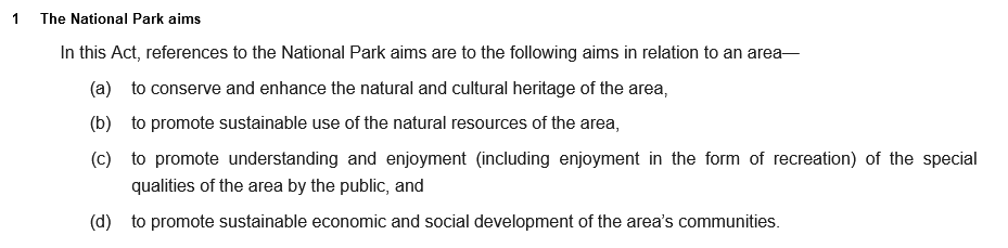
The proposed mast at Ryvoan, and others like it, are clearly not wise use of natural resources (we need to start consuming less if the planet is to survive) but rather examples of unsustainable development. The only reason they are happening is the UK Government has agreed to pay for them through the SRN programme.
Up until now the CNPA has had a very poor record when it comes to assessing whether planning applications are compatible with its statutory aims. The best example is just across the hill from Ryvoan at Cairn Gorm. The CNPA approved the planning application to repair the funicular without assessing whether the £73.09 in public subsidy HIE had committed in its Business case over 30 years (see here) was wise use of resources. Nor did consider whether the repairs would work and therefore whether what was proposed was sustainable. In other words the CNPA could have used its planning powers to prevent HIE’s funicular disaster at Cairn Gorm but failed to do so.
The CNPA should not make the same with telecommunications masts. It is quite predictable that whatever their short-term impacts on landscape and wildlife in ten years time or less they will be reduced to rusting hulks in what once were unspoilt areas of the countryside. It is time the CNPA took a stand, started to act like a National Park and in doing so did the whole of Scotland a favour by forcing the UK Government into a re-think.
You can comment on the application (see here) but be mindful that the CNPA quite unfairly restricts the time the public have to comment on applications to the statutory minimum, 28 days from 10th July.

Just to underline Nick’s comment about emailing Peter Lyle, there’s a coalition of 13 organisations including the JMT, NEMT, RSPB, Mountaineering Scotland that are planning to write a combined letter to PL at the end of the month as they are of the belief that the programme could be under review. Individual contributions are encouraged to support it.
Rt Hon. Peter Kyle
Secretary of State
Department for Science Innovation and Technology
100 Parliament Street
London SW1A 2BQ
E mail: Secretary.State@dsit.gov.uk
Rt Hon. Sir Chris Bryant
Minister of State for Data Protection and Telecoms
Department for Science Innovation and Technology
100 Parliament Street
London SW1A 2BQ
E mail: Correspondence@dsit.gov.uk