[Ed note. While I wrote about the proposed mast on Creag Dubh in a previous post (see here), this objection to the Planning Application from Dave Morris sets out a reasoned and detailed case about what is wrong with the Shared Rural Network programme and the approach they are taking to fixing the “partial not spots” which affect people living, working and travelling through rural areas. The Creag Dubh mast application has now been readvertised (ref 23/04700/FUL on Highland Council planning portal) and further comment should be made asap. Meanwhile further pressure needs to be applied to the UK and Scottish Governments to reform the whole of the SRN programme before any more time and resources have to be spent by planning authorities and the public in Scotland in dealing with dozens of flawed planning applications]
Proposal
Installation of 25m high telecommunications mast and ancillary development within fenced compound
At altitude 430m (GR 665 957) on Creag Dubh (756m), between Laggan and Newtonmore, Cairngorms National Park and Ben Alder, Laggan and Glen Banchor Special landscape Area
You can comment on the application Highland Council ref 23/04700/FUL see here
Context
This planning application is part of the Shared Rural Network 4G digital telecommunications mast programme being promoted by the UK Government. This programme has been severely criticised by a wide range of voluntary and public bodies for its potential impact on the natural beauty of Scotland and for its practical value. On 11 Jan 2024 the Highland Council passed a motion which called on the UK and Scottish Governments to pause, review and improve the SRN programme.
There is a fundamental flaw in the criteria used by the government in identifying where such masts are needed. They are attempting to achieve mobile phone coverage over 95% of the UK land mass, including very large areas in Scotland where there is no resident population. Such coverage is not needed for business, land management or public safety reasons. Anyone who has concerns about going into such areas can use satellite technology and personal locator beacons to communicate to other locations if need be. Satellite-to-mobile services are developing rapidly in other countries and it is obvious that many of the new phone masts being proposed for rural areas in Scotland will not be needed in a few years time.
If the SRN programme is to continue the criteria for the mast site selection needs to be changed so that it is based on population need, not on area coverage. Coverage should meet the needs of 95% of the resident population and public road network, not huge tracts of wild country where nobody lives and there are no public roads. These issues have been covered in recent weeks in 8 posts on Nick Kempe’s blog, parkswatchscotland. Note especially the posting by Robert Craig on 17 Jan.
In the case of the proposed Creag Dubh mast the developers are Virgin Media and O2, with the planning application submitted by their agents, WHP Telecoms, operating from their Northern Ireland office. This planning application was wrongly advertised and, in trying to explain how the application met the requirements of the Local Development Plan, the applicants used the wrong LDP. They also failed to make any reference to the principal landscape designation in the area, the Ben Alder, Laggan and Glen Banchor Special Landscape Area. The application also incorrectly states that there would be no impact on public access rights on Creag Dubh.
The planning application referred to further information relating to other masts, including mast sharing with other operators as well as an alternative location for the proposed mast. Unfortunately, when asked to provide this information, the applicants refused my request.
The competence of Virgin Media and O2 and their agents, WHP Telecoms, in the development of mobile phone masts in Scotland needs to be questioned. If their performance in promoting this particular planning application is an indication of their competence in pursuing similar projects elsewhere then the natural beauty of Scotland would appear to be in jeopardy in many other locations.
I made some preliminary comments on the planning application on 1 Feb in which I explained how this planning application was incorrectly advertised. By using the wrong postcode, either inadvertently or deliberately, the public were misled into believing this proposed mast was close to Newtonmore and nowhere near the western flank of Creag Dubh and the settlement of Laggan. This incorrect advertisement means that the level of objection to the proposed mast is probably much less than if people had realised where it was proposed. Nevertheless I note that HC directly consulted Laggan Community Council (LCC) about the planning application and they have objected to the proposed mast. I support what LCC have said. My own reasons for objection are as follows.
Impact on wildness value
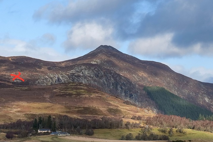
Creag Dubh is one of the most prominent hills in the Badenoch area of the national park, visible from a large number of surrounding hills and the settlements on lower ground. The south west shoulder, which narrows to a rocky ridge towards the summit, is a particularly distinctive feature, visible not only from nearby hills but also from much of the low ground in the strath. The lower slopes contain tracts of moorland and natural woodland, mainly birchwood, along with some plantation forestry. The proposed mast location is situated in the moorland on this shoulder and would intrude into what is recognised as the most iconic view of Creag Dubh from the west and south. Relocating the mast to a different position on the shoulder would make no difference to the extent of intrusion. The planning application includes a document headed Zone of Theoretical Visibility. It clearly demonstrates how visible this mast would be from much of the strath to the west and south, from all the moorland area between the Scots pine woodland on the west flank of the shoulder and the birch woodland and cliff on the east flank, and all the way to the summit along the shoulder. When ascending and descending from the summit the mast would be visible at virtually every stage, intruding into the view down into the strath and, at lower levels, also interrupting the view to the west over many hill ranges as far as Ben Nevis.
The proposed development lies within areas of national importance, namely the Cairngorms National Park and the Creag Dubh Site of Special Scientific Interest, and of regional importance, namely the Ben Alder, Laggan and Glen Banchor Special Landscape Area. The SLA is designated by Highland Council, the determining authority for this planning application.
The SLA citation, under the section “Key Landscape and Visual Characteristics” explains:
“There is a strong contrast between the glens and the upland areas. In the glens, human influence is clearly apparent, for example in the distinct pattern of fields, enclosed by policy woodlands and forest plantations, and punctuated by buildings, conversely, the mountain and moorland areas are simple in land cover and possess wildness qualities”.
And the citation goes on to make a specific reference to Creag Dubh under the section headed “Special Qualities”:
“This area includes some striking landscape features: Coire Ardair, on Creag Meagaidh is one of Scotland’s most dramatic corries; Creag Dubh, near Newtonmore is one of Scotland’s most impressive roadside crags; and the Dirc Mhor, off the beaten track in the hills west of Dalwhinnie, is one of the country’s best examples of a glacial meltwater channel.”
Despite making no reference to this SLA in the planning application, the applicant does acknowledge the wildness value of Creag Dubh in their statement: “The area is considered sensitive to development which would compromise wildness and it is identified that careful sighting is absolutely necessary to retain the undeveloped feel”. It is very difficult to imagine how “careful sighting” could be used to “retain the undeveloped feel” of this area of Creag Dubh. Its location in an area of open moorland, high on the hill and close to the cliff top and main public access route up and down, precludes any possibility of retaining the wildness character of this area, either in the immediate vicinity of the mast or from more distant locations in the hills and strath.
Quite apart from the choice of site location, other proposed mitigation measures, involving for example an open lattice structure for the mast and appropriate choice of paint, are trivial measures when considered within the overall landscape impact of this proposed 25 metre mast and its associated cabins, hard standing and fencing. It is not surprising that the LCC has summarised their position as follows: “For the many visitors who head for Creag Dubh, the mast will have a significant detrimental visual impact”.
Public access
In the planning application document published on the HC portal on 29 Sept the developers answered “no” to questions about whether their proposed development would affect any public right of access or footpaths. This is an incorrect statement. Public access rights apply to all of the land within the proposed development and the surrounding land on Creag Dubh. None of the other documents submitted by the applicant in support of this development make any reference to the scope and scale of public access on Creag Dubh, as established by the Land Reform (Scotland) Act 2003.
Creag Dubh is one of the most popular hills for walking or running in Badenoch, for residents and visitors. It enjoys all year round use and is an excellent alternative location when adverse weather conditions affect the higher hills of the Monadhliath and main Cairngorms massif. Its location close to the A86 and proximity to Laggan, Newtonmore and Kingussie give it special significance, along with its rugged character, prominent skyline, extensive birchwoods, open moorland and a famous cliff and waterfall. Most ascents and descents are by way of the western flank, with various routes connecting to the A86 on the lower slopes. These converge on the open moorland, in the vicinity of the proposed mast. Traverses of the summit ridge are common, connecting the River Calder at the eastern end by Newtonmore with the western flank.
Winter use includes ski touring, through the moorland area proposed for the mast and either to the summit via the northern flank or over the col to connect with Glen Banchor. For the climber, walking off the top of the impressive Creag Dubh crag onto the descent route back to the public road, the expansive view of the wild moorland would be dominated by the telecommunications mast and its associated infrastructure. Or someone admiring this crag from afar would see the mast a short distance beyond the cliff top – an artificial construction on a hill otherwise dominated by natural features.
Some parapenting from the summit area has been taking place in recent times and, depending on wind direction, the presence of a mast on the western flank could compromise safe landing on the open moorland area.
Trekking on horseback is a long standing tradition in this part of Badenoch along with the more recent development of mountain biking activity. Existing tracks on the lower slopes provides good access routes for these activities while the more distant views of Creag Dubh from tracks elsewhere in the strath would be impaired.
The proposed mast would not be visible from the A86 as it passes underneath the slope below the mast site. But it would be very prominent from other public road locations, notably the A 889 between Dalwhinnie and Laggan and the minor road between Cat Lodge and Glentruim.
Fourth National Planning Framework (NPF4)
NPF4 includes the requirement, in Policy 23 (d), that development proposals for telecommunications facilities should be supported where:
- the visual and amenity impact of the proposed development has been minimised through careful siting, design and where appropriate landscaping;
- it has been demonstrated that all practical options and alternative sites have been considered, including the possibility of using existing masts, structures and buildings and/or site sharing;
The applicant’s planning application does not meet the requirements of this NPF4 policy on both accounts: the great difficulty in minimising the visual and amenity impacts associated with their preferred location for the mast and associated cabins on the south west shoulder of Creag Dubh, as explained above, along with their failure to explain why mast sharing or alternative locations are not suitable.
Mast sharing
In their planning application the applicant states: “the four MNOs [Mobile Network Operators] are coming together to share new and existing masts in areas that are identified as digitally underserved. This will save operators needing to build duplicate infrastructure whilst eradicating the proliferation of infrastructure, as well as helping to make cost savings and limit overall environmental impacts” (Industry Site Specific Supplementary Information (ISSSI), page 3).
Despite this requirement the applicant has made no attempt to explain why mast sharing with other mobile phone operators in this area is not possible. There is an EE mast at Cat Lodge and a Vodaphone mast at Wolftracks, both of which already give good signal coverage over the main settlements associated with Laggan and over most of the public road network. In their planning submission the applicant has stated “A coverage map can be provided on request” in the section headed “Enclose map showing the cell centre and adjoining cells” (ISSSI, page 7). I requested a copy of this map but the applicant replied on 12 Feb with the statement “Unfortunately, masts in the wider area are commercial sensitive and I am not able to share information with the wider public”. This refusal to explain why mast sharing is supposedly not possible is in direct contravention of NPF4 and the guidance on telecommunications mast installation provided by NatureScot.
The developer explains that this proposal in Badenoch is within a “Partial Not Spot” [PNS] which is “a geographic area served by at least one, but not all four mobile network operators”. They say that “although this area is “covered” by one mobile operator [in fact there are two, at Cat Lodge and Wolftracks], the standard of coverage is rather basic”, suggesting that “this is a serious social and economic issue because public use of mobile communications has also changed from bring mainly for business or luxury use, with a few million privileged customers”. I doubt if many of the existing Vodafone and EE customers in Badenoch agree with applicant’s assertion that they are using a “luxury” item and are specially “privileged” to have access to such a facility. Neither would I anticipate that any local residents would describe the absence of Virgin Media and O2 coverage as a “serious social and economic issue… that deprives locals essentially of choice and competitive options”. The desire of Virgin Media and O2 to expand their customer base does not warrant the degradation of Creag Dubh’s environmental quality, especially when two of their competitors appear to be providing an adequate service in this area.
Alternative site
If, however, mast sharing proves to be impossible and a new mobile phone mast is needed between Newtonmore and Laggan then it should be located on the opposite side of the strath, between Cat Lodge and Glentruim. This is the alternative location already identified in the planning application, but dismissed by the applicant for what appear to be spurious reasons. Or a different location should be identified and agreed with the Highland Council, as planning authority, in negotiation with Dalwhinnie, Laggan and Newtonmore Community Councils. Potentially all three CCs have an interest in any proposals to locate a new telecommunications mast in this area of Badenoch.
But the applicant’s information about the possible alternative location for a mast, on the opposite side of the strath, is wrong and incomplete. The applicant describes this location (close to the Allt Mhoraich, between Cat Lodge and Glen Truim, at grid ref 658 930, on the northern slope of Creag na Sanais) as follows: “Although this location would benefit from screening from the nearby trees, the access track would require significantly more upgrade works. The track is heavily torn up by large tractor tracks. This is considered to have a higher environmental impact on the environment that what is currently proposed. It may also be subject to tree lopping” (ISSSI, page 13).
In reality there are no deep ruts on this track and any overhanging branches from nearby birch trees can be easily dealt with. The whole of this track, up to the potential mast site and beyond is readily accessible by 4 wheel drive vehicle, along with a modern bell shaped entrance onto the minor public road between Catlodge and Glentruim. This is a far safer entrance/exit location than the proposed Creag Dubh location on the busy A86.
The environmental impact of this alternative location at 350 m on Creag na Sanais (summit is at 590 m) would be much less than the proposed site on Creag Dubh at 458m. It would be visually far less intrusive, both in the near and distant views and would impact on relatively few people given the low levels of public access on this particular hill. It has a better line of site to Balgowan, the settlement just east of Laggan and also to residences along the A86 from there towards Newtonmore. When travelling along the A 86 it is this section of the public road which usually has the weakest signal – this would not be improved by the proposed new mast on Creag Dubh. The planning application shows several blank sections along the road where the steep hillside to the north obscures the view to the proposed new mast (see “Predicted SRN Coverage of 24087” in the Coverage Prediction document).
On 7 Feb I emailed the applicant about this alternative site as follows ”I would be grateful if you could send me the following information concerning the above planning application which is contained within the document Industry Site Specific Supplementary Information. On page 13 there is reference to an alternative site called D1-Greenfield within postcode area PH20 1BE. The information provided about this site is very limited, focussed mainly on the state of the access track and an issue about tree lopping. Presumably a site visit was made to this location, so could you please send me the actual report that refers to these matters and any other relevant information that you hold, including the site’s suitability from a telecommunications perspective both in terms of operational requirements and location”. The response to this question was received on 12 Feb and contained within one sentence: “The alternative option “D1” was assessed by a team of multi-professionals, and was deemed unsuitable to proceed”. In other words, everyone with an interest in this planning application, including the planning authority, is supposed to accept that no explanation of the technical suitability of an alternative site is to be considered during the planning process. They seem to believe that only their own “professionals” should have access to this information – the rest of us have no way of assessing the validity of the alternative option that is a central consideration in determining this planning application.
Local Development Plan
The applicant correctly states the need for their planning application to comply with the policies contained within the relevant LDP. They then provide a detailed explanation of the reasons why they believe the proposal complies with the Highland – wide LDP. Unfortunately this is the wrong LDP to be used in the determination of this planning application. The first sentence of the LDP explains this quite clearly: “The Highland – wide Local Development Plan (HwLDP) is our vision for the whole area (excluding the area covered by the Cairngorms National Park which has its own plan) and sets out how land can be used by developers for the next 20 years. So, when determining this application, the Highland Council are required to use the Cairngorms National Park Authority’s LDP.
The CNPA LDP requirements with regard to mobile phone masts are set out in the LDP’s Policy 6: The Siting and Design of Digital Communications Equipment. The planning application does not comply with policies 6 a), b) and c).
Policy 6a) requires “details of the siting, design and appearance of the proposed apparatus and associated structures demonstrate that the impact on the visual amenity, character and appearance of the surrounding area is minimised”. The impact of the proposed development has not been minimised either in terms of the landscape and high levels of public access and enjoyment associated with Creag Dubh, both in the vicinity of the proposed development site and in views of the site from afar. The applicants could probably not have chosen a worse location for this proposed development, as regards policy 6a), on any hillside between Laggan and Newtonmore.
Policy 6b) requires “in sensitive areas detailed evidence demonstrates that the proposals would not lead to unacceptable effects on areas of particular ecological or landscape importance; archaeological and other cultural heritage sites; conservation areas; or buildings of architectural or historic interest”. The applicants have made no reference to the presence of Creag Dubh within the Ben Alder, Laggan and Glenbanchor Special Landscape Area and the recognised “wildness qualities” of this SLA. Nevertheless the applicants recognise the wildness quality of their proposed location on Creag Dubh and the risk that this could be compromised by the mast development. The proposed careful siting and other mitigation measures would have a negligible effect in reducing the landscape impacts that are evident from the visual assessments provided by the applicant.
Policy 6c) requires “opportunities for mast and site sharing as well as installation possibilities on buildings or other existing structures have all been fully considered and such opportunities taken wherever appropriate and practical”. The applicants have provided no evidence to explain the extent to which they have explored mast and site sharing possibilities or why they have rejected a potential alternative location which would appear to be a better location for a new mast.

Well done Dave, objection submitted. I hate to think how much public money has been wasted on the SRN programme so far.
A fair few of these applications come with highly misleading location references in their titles. Thus “Ski Centre, Glen Coe” (24/00289/FUL) is actually located between Ba Bridge and Ba Cottage, while Station House, Corrour (24/00172/TPNO) refers to a site some distance along Loch Treig. Roy Bridge can be many things, and in the case of 23/05896/FUL it is actually the Lairig Leacach opposite Sgurr Innse. As for “Water of Nevis” 23/05699/FUL, it’s an anodyne label for one of the most ludicrous and inappropriate proposals of them all, at the watershed near Tom an Eite.
One thing bugs me a it about these communication masts. A large communication mast was erected on the summit of a hill about one mile south of our house. Discussing it with a neighbour revealed a surprise. If you stand in front of his house with the mast south of you and in view and get out a compass, the north end of the needle points south – straight at the mast. If you stand at the rear of his house with the house between you and the mast, the north end of the needle points north – a sit should! Would such disturbance of the magnetic field arise around this new set of communication masts and, if so, how do you navigate in the hills?
That’s a very, very interesting discovery. I don’t know who you would ask, though, to get clarification.