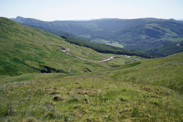
The night before going on holiday a couple of weeks ago, I was on the Question and Answer Panel organised by Patagonia following the showing of their fantastic film Blue Heart in Edinburgh (see here for film – 45 mins). The discussion (a podcast of the event is being produced) focused on the similarities and differences between the destruction going on in the Balkans – 3000 hydro schemes in Albania alone – and Scotland.
In the Balkans, there are still sizeable communities in rural areas whose livelihoods have been put at stake and who have been leading the opposition. In Scotland, people have been cleared from the land and those that remain in the remoter areas where hydro schemes are being built are mostly dependent on landowners, whether for work or housing. Hence, in Scotland, unlike in the Balkans its been outdoor recreationists who have been leading the opposition to hydro schemes, with some notable exceptions such as Councillor Andrew Baxter at Glen Etive.
All the campaigning recreational organisations, Mountaineering Scotland, Ramblers Scotland, Scottish Wild Land Group, John Muir Trust were at the event and there was a real sense that the Glen Etive Hydro Schemes have marked a turning point. There was also general agreement that in respect of protecting landscape, wild land and ecology our planning system, whether inside or outside National Parks, is broken and that concerted action is now required to prevent further damage and restore the considerable damage that has been caused by run of river hydro schemes to date.
Although the Feed In Tariff which has driven the development of hydro schemes across the UK may have come to an end for schemes which have not yet got planning approval, there are still a significant number of schemes in the pipeline, including the seven in Glen Etive. Photos sent to me this week by Tom Prentice, who has produced two excellent walking guides to the Lomond and Trossachs National Park (see here), provide a timely reminder about why those concerned about hydro schemes need to remain vigilant, even in our National Parks.
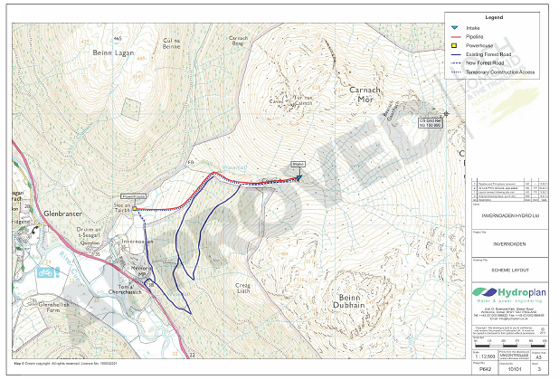
The Invernoaden Scheme was originally approved back in 2013. A new planning application was then approved by officers in 2017 (see here) and construction work appears to have started only this year. There were no objections to the scheme and no representations from the local community. As is their usual practice, the Loch Lomond and Trossachs National Park Authority has not published any of the documents it required post granting planning consent, which makes it very difficult for any member of the public to tell whether planning conditions are being observed or not. This makes it very difficult for anyone to complain.
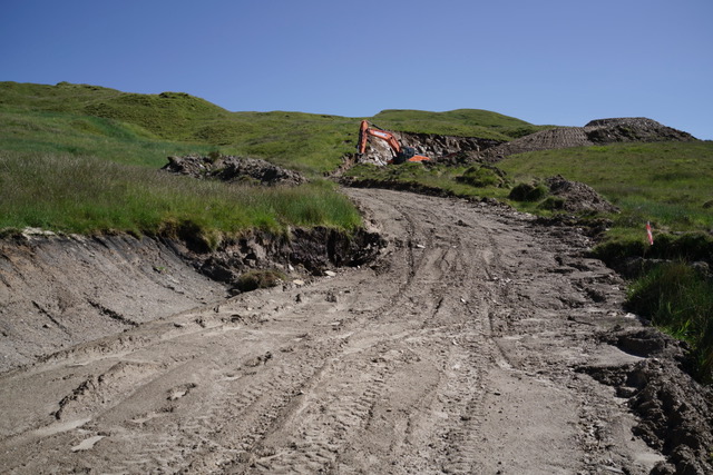
While the documents might not be available, the planning consent required the developer to appoint an Ecological Clerk of Works to monitor the construction and also required a turves management plan to ensure that turf and topsoil which was removed during the construction process was stored properly so it could be use to restore the temporary construction tracks once the work completed:
“3. Treatment of Peat and Turves: Prior to the commencement of development a turve management plan for the whole site shall be submitted and approved by the Planning Authority. This shall include details of:
-
- The storage and management of the different habitat types and turves of different sizes and depths; and
- Coding of habitats to ensure habitat turves are reinstated in the correct areas.
The details to be provided under Condition 1(k) shall require the pipeline route to be exposed in short sections only (to be defined and agreed under condition 1(a)) and turves associated with the construction of the pipeline shall be stored for a maximum of two weeks”.
The photos suggest the turves have been dumped, rather than stored as per the condition, so I have submitted a complaint to the LLTNPA and asked for a copy of the turve management plan. Although this document could be published on the planning portal with very little effort, the LLTNPA is treating this as an FOI request and told me they will respond as soon as possible or within 20 working days. On past experience, “as soon as possible” will turn out to be the full four weeks.
The key point, however, is that the leaving monitoring of hydro schemes to Ecological Clerks of Works who are dependent on the developer for their pay gives carte blanche to developers and contractors, who are under pressure to undertake work as cheaply as possible, to ignore planning conditions.
Planning enforcement staff should be on site right from the start and treat any breach of planning conditions as a reason to suspend all operations. That would cost developers and focus minds. Instead, even in our National Parks the level of independent monitoring of schemes is risible and as a consequence our planning enforcement system does not work.
Without planning enforcement, all the documents which developers have to produce to get planning applications approved are simply an expensive charade. The multitude of documents support an army of consultants and protect the backs of planning authorities with very little demonstrable benefit to the natural environment or people.
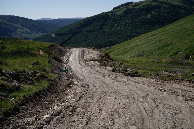
Although the map (above) shows there are already three forestry roads close to the scheme, which could have enabled the intake and powerhouse to be accessed on foot, the LLTNPA nevertheless agreed to the creation of two “Permanent forest road spurs extending from existing forest roads to the intake and powerhouse”. The language tells a tale. These are NOT forest roads and indeed won’t be built to UK forest standards because the Planning Officer has rightly required them to be narrowed to 2.5m post construction. Why describe roads on the open hillside as “forest roads” then? That’s extremely misleading as it suggests the roads will be screened by trees and helps maintain the fiction that all the new roads being created have not had a significant impact on the landscape in the National Park.
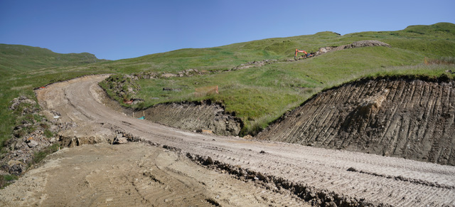
While the main section of construction road which will be used to bury the pipeline is to be fully restored, there are questions about why in this case was it ever needed? On the Gynack Hydro scheme above Kingussie in the Cairngorms (see here) winching equipment was brought up by the existing road and the pipeline then winched up alongside a trench dug with small diggers. The impact on the landscape was as a consequence far less than in other hydro schemes. Why not here? The problem, I suspect, is that planning staff are not encouraged to spend time learning and sharing best practice but are instead under pressure to consent to schemes in as short a time as possible.
Reading the Officers Report (see here) is like reading a tick box exercise. That is not the officers fault but that of the planning system. The assumption, which is driven by the Scottish Government, is that all development is good and the presumption is that every possible impact can be satisfactorily mitigated. Strategic questions are avoided:
- what will the net impact of this hydro scheme have on carbon emissions after the emissions caused by the construction (concrete, pipes fabricated out of oil based products, destruction of peat, fuel) are taken into account?
- why are new permanent access roads required and what will be the cumulative impact of all these roads be on the landscape? (A major issue at present as much conifer forestry reaches maturity and is felled)
- what has been the cumulative ecological impact of diverting so much water from what were wild river systems in the National Park?
- are there better ways that this land could be used, including its potential to abstract carbon from the atmosphere?
Where next?
I hope that with increasing levels of concern being expressed by the public, the next year will see a far more strategic debate about the role of run of river hydro schemes in tackling climate change weighed against their impacts on the natural environment. Our National Parks should have been in the vanguard of the debate but instead unfortunately are part of the problem. We need more organisations like Patagonia and the Mountaineering Scotland who are prepared to take on these issues.
Meantime, if you come across a hydro scheme, whether operational or under construction, and see anything of concern please take photos, pass them on to interested organisations (parkswatch is happy to help with this) and share them on social media.

So much for hoping that this dire scheme would never get built. The spectacular, tree-fringed waterfall downstream will be reduced to a miserable trickle. A friend and I climbed Beinn Bheula in March of this year and were horrified to discover markers indicating that a hydro scheme was in the offing. We asked at the Whistlefield Inn, where we were staying, about local views on the hydro plans. The owner looked blank, had heard of the plans but wasn’t bothered. She implied that nobody locally cared about the hydro, but everyone was up in arms over the proposed fish farm. This is perhaps the main problem: the locals just do not care about these hydro schemes. Why would they, after all? How many of them make their living from a corrie that most visitors – other than determined hill walkers – wouldn’t make the effort to visit? Their clientele arrives by road, sees nothing if it can’t be viewed through a windscreen, departs the same way. You’d need a whole battalion of outraged hillgoers to make a difference, and I’m afraid too many walkers seem reluctant to comment – all I can say is, they must wear very effective blinkers on the hill.
I wonder how many visitors don’t actually realise what being a national park should imply about how the landscape is cared for? Elsewhere in Scotland we see the countryside ‘managed’ in many different ways. Perhaps folk fail to realise that the park status should lead to a much higher standard… Their expectations remain unchanged. I don’t recall all those ‘don’t camp here’ signs being accompanied by anything educational about the aims of the park… are there any?
It’s horrific to see the massive scarring of our hillsides from the construction of these small hydro schemes and the uncontrolled growth of hill tracks to meet the needs of the grouse moor estates. The problem, however, is a much larger one. As you say, Nick, the problem is the assumption, which is driven by the Scottish Government, is that all development is good and the presumption is that every possible impact can be satisfactorily mitigated. This is compounded by a total failure of the planning enforcement system, due to systematic undermining by the Scottish Government. These problems don’t just hit hydro schemes and hill tracks, but hit the whole planning system. It takes strength of will from any planning authority these days to objectively appraise planning applications and enforce planning conditions. Concerning the latter, I wonder why planning authorities bother with planning conditions any more as in my experience they very rarely, if ever, enforce them.
Within 10-15 miles of here in Lochaber I could point out more than 15 new hill tracks, all excavated in the past 5 years to facilitate micro hydro installations. Each of these earlier, grant subsidised, projects could have had planning obligations requiring mitigation and re-landscaping after construction. The excuse for large machinery to revisit the header dam after installation of pipe stock is worthless. Each track is “private” therefore no right of access exists. No requirement to care for heritable landscape or enforcement of contract standards is in place. Few people ever walked these areas, and no one else locally appears to care much.
The most startling and sad example these past months is far from here. Descending from Moulin hill above Pitlochry, the view west across the Tay valley now includes a vast newly excavated scar running north, high along the far ridge line above Loch Tummel. There never has been any need to take any vehicle along the skyline of that ridge before – this road is too high for hydro catchments. Perhaps it’s for new forest plantations or extraction below the ridge …if so …why now ? A visitor traveling along the A9 may never notice, but should they climb any surrounding hill east of Pitlochry looking west , this example of wilfull destruction is in full view. Must we continue to be grateful for Government complacency over regulatory inattention, while the pristine hills we inherited are scarred for ever?
In answer to the question posed above just last week, I am informed the cause of this new hilltop road visible from Moulin hill is linked to this approved mine project. https://duntanlich.com/about-duntanlich/ The “haul road” to the batching plant is needed t keep traffic from minor adopted roads. The new excavation is supposed to be out of sight to users of the A9..and … out of sight, without mitigating landscaping measures is OK ?