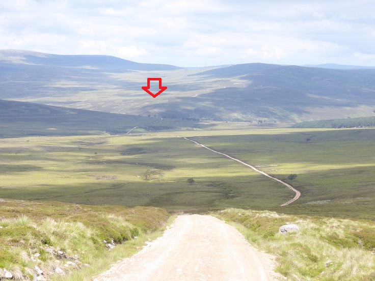
On 5th February a planning application was published on Highland Council Planning portal to erect a 27.5m high telecommunications mast along with 2 x 15m wind turbines and 36 solar panels in the heart of BrewDog’s Lost Forest (see here). While the application states “the proposed site is located towards the foot of Creag Shollier, in a highly remote, predominantly upland area of the Scottish Highlands” the mast would actually be just below the summit and less than 2 km distance from the bothy where James Watt, the founder of BrewDog, had come for several days in 2022 “to switch off”. (see here).
The planning application form states the landowner, i.e. BrewDog, has been notified although nothing about what discussions have taken place with them to date. With the applicants, Mitie on behalf of 3UK, proposing that access to this highly remote location in the Monadhliath Wild Land Area should be via the Burma Rd through BrewDog’s Lost Forest it seems unlikely that there have been no talks with the company. It is possible, however, that James Watt is unaware of the proposal and when he hears the experience he had in the bothy will no longer possible he will instruct his staff to object in the strongest possible terms.
Unfortunately, its far from clear that BrewDog values wild land. Back in 2000 BrewDog was talking about erecting a windfarm on the Lost Forest (see here) and the only possible location for that would be the Wild Land Area given the planning presumption against windfarms in National Parks. Also, so far as I am aware, BrewDog has as yet produced no proposals to “re-wild” the Wild Land Area by removing the roads that cross into it, including those below Creag Sholleir where the new mast is proposed. But perhaps after this stay in the bothy James Watt has changed his views and highly values remote unspoiled areas?
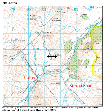
The boundary of the Monadhliath Wild Land Area runs from the watershed with the River Spey and the boundary with the Cairngorms National Park parallel to the Burma Road and across over the summit of Creag Shoilleir. The planning application does refer to the Wild Land Area and to NatureScot’s description of it:.
“The wider landscape is characterised as being part of the Monadhliath Wild Land Area, which is described by NatureScot as compromising [sic] a long range of large rolling moorland hills and plateauxs, most of which rise above 600m ASL. The hills appear stunning in their simplicity, openness and immense scale…………..These immense natural features and the wild character of the application
contribute to creating an environment that is extremely challenging for the provision of essential modern telecommunications infrastructure”
Instead of assessing the impact of the mast on the wild land qualities of the area the supporting statement asserts that the provision of telecommunications in such areas “essential”. The useful map provided by the applicant casts light on what that actually means:
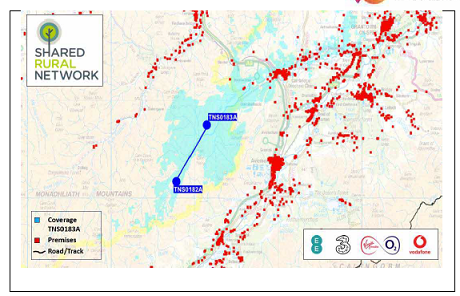
The map helps show that the only human habitations, as opposed to the bothy and various other estate huts, that will be covered by the mast are around Carrbridge (the cluster of red blobs by the A9). These are in fact already covered by a mast just above Carrbridge.
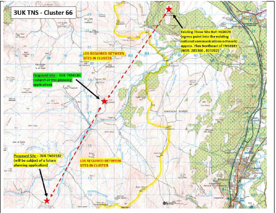
The proposed mast in the “Lost Forest” will therefore make no difference to the lives of the vast majority of people living, working or travelling through the area. The Supporting Statement fails to mention that the people who might benefit by mobile communications in the wild land area, like mountain rescue teams and estate staff, can if they want get better and more reliable coverage through satellite phones.
Some of the Mitie’s attempts to use National Planning Framework 4 to justify the application would be funny if what is at stake, the preservation of wild land, was not so serious
“Policy 13 refers to sustainable travel and confirms that developments which ‘reduce the need to
travel unsustainably’ will be encouraged and promoted.
In accordance with Policy 13 of NPF4, it is well known that the availability of high-quality digital
communications can reduce the need to travel by allowing more people to have the opportunity
to work from home, thereby cutting down carbon-emissions produced by commuting”.
If like me after reading this you were hoping the application would reveal the whereabouts of the Monadhliath cave dweller who currently commutes to Aviemore for work you will be disappointed.
“It is commonly understood that the provision of digital technologies had the ability to significantly
reduce global carbon emissions. According to MobileUK’s publication: ‘Connectivity and Climate
Change,’ high quality communications and connectivity can have a positive impact on accelerating
the move to wind and solar energy; reduce emissions from transport; and transform the
agricultural industry and rural economy through the use of drones and sensors connected to
mobile networks. In the most remote locations, high quality digital connectivity has the potential
to assist with many aspects of rural land management including deer surveys; protected species
monitoring; peatland and woodland restoration monitoring; and re-wilding monitoring and
reporting”
Mitie has provided no report to showing how much CO2 will be emitted in the manufacture, transportation and construction of this mast and the associated “green infrastrucuture” of panels and wind turbines let alone how it will transform the rural economy. This is just greenwash and shows no understanding that the whole point of wild land is it should be wild, nature should rule and there really isn’t much “economy” (and even less since the Lost Forest stopped employing permanent staff (see here)).
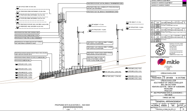
The height of the proposed mast, 27.5m, is more than the usual 25m of masts in the Shared Rural Network programme. While it is hoped to power the mast through renewable energy produced on site the application also includes a Standby power generator just in case.
This structure, so Mitie claims:
“will make a significant contribution towards meeting the six qualities which are considered to make successful places. The development has the potential [only potential note!] to contribute to making the area more ‘Healthy’ by providing a reliable communications system for the many people working (often lone working), living and visiting remote parts of the country. The ability to make contact with other people or the emergency services in the event of an incident in these very remote areas can, at times, save lives. The provision of digital communications connectivity also contributes to the qualities of being ‘Connected’ by providing a well-connected communications network and reducing car
dependency and ‘Sustainable’ by providing resources that allow people to, ‘live, play, work and
stay in their area.”
Perhaps someone should tell the developers behind the Shared Rural Network that Wild Land Areas are not “places” like human settlements being shaped more by nature than by humans?
Having failed to assess the impact on the Wild Land Area – the application describes the location of the proposed mast as “unused land” – the supporting statement then concludes:
“Overall, it is considered that any minor harm caused is clearly outweighed by social, environmental or economic benefits that high quality digital communications will provide to people working, living and visiting this area.”
This nonsense dis riven by the c£1m subsidy the UK Government is providing to build new masts in Total Not Spots, ie areas where no-one lives, where very few work and which most visitors value precisely because they are places where you can get away from modern telecommunications and be self reliant.
How to help save the Monadhliath wild land area?
The landscape of Scotland’s wild land areas is now threatened as never before with c470 mast applications in the pipeline as David Craig’s recent post shows (see here). Its impossible even for the most dedicated campaigning organisations to keep up with what is going on let alone respond. Pressure therefore needs to be put on politicians and decision-makers.
It would really help with individual applications, however, if landowners opposed these structures being built on their land, as many are now doing (subject of a forthcoming post). The example set by high profile landowners like BrewDog is very important and one would hope they might now show a lead in protecting the Monadhliath Wild Land Area given their CEO was reported to have enjoyed his off-grid stay in the bothy. It might help if people contact hello@brewdog.com and ask them to object.to the application.
Experience to date is that when there are a significant number of objections to an application they are often withdrawn (if only temporarily) If this one were withdrawn it would also stop the proposed mast further up the Dulnain. If you want to object you can do so on the Highland Council Planning portal (planning reference 24/00348/FUL (here)).

Objection is in already!
Thanks Nick, this one has also popped up on the list posted by JMT. Objection submitted.
I came across a telecoms mast in Leanachan Forest recently. The generator was noisy and stank to high heaven. Nil landscaping effort. They seem not to have availed themselves of a connection to the cables running from the adjacent ROR hydro (Allt Coille Rais, I think, the one that’s supposed to power the Nevis Range facility). You could say that with the ugly sitka plantation and the hydro-ing of most of the poor corries it’s not the most damaging location for a mast – but it is still brutal. Not sure whether it’s of benefit to the Nevis Range complex or not. A Glen Nevis local told me that there’s been a mast in that glen for the past two years, not even transmitting (!) but with a diesel generator constantly running. I didn’t visit the glen on my recent trip so I’ve no idea where the mast is. Presumably it predates SRN.
Where is the forest you planned to establish?
Repeating what I’ve just posted elsewhere on this site:
The lastest update on the John Muir Trust website shows applications have been submitted for a mast next to Blackwater Dam (Highland Council, 23/05603/FUL) and one above the Water of Nevis (23/05699/FUL), south of Stob Coire an Laoigh, a stone’s throw from the long-distance path through from Steall to Luibelt bothy. There are other new applications I’ve not had time to look at, This is madness. Did Highland Council ever write that letter, does anybody have an update?