In a recent post on the proposed telecommunications mast at the western end of Loch Mullardoch (see here), I criticised the organisations which have rightly formed a coalition agains the Shared Rural Network programme for not campaigning hard enough to protect Scotland’s finest wild land from descretation.
Those organisations – I am a member of most – made up for it last week with a surge of coverage in the more liberal media, e.g the BBC (see here) and Herald (see here). That should help bring the issues to the attention of politicians. At the same time most of the organisations have highlighting the issues to their own members in the last couple of weeks: e.g the National Trust for Scotland (see here); Mountaineering Scotland in the Scottish Mountaineer and John Muir Trust in their newsletter. Coupled with other recent coverage from the likes of Chris Townsend (see here) and UK Hillwalking News (see here), most outdoor recreationists should now have some awareness of the landscape implications of blanketing the Highlands with telecommunications masts. The challenge now is to turn that awareness into pressure which the politicians cannot ignore
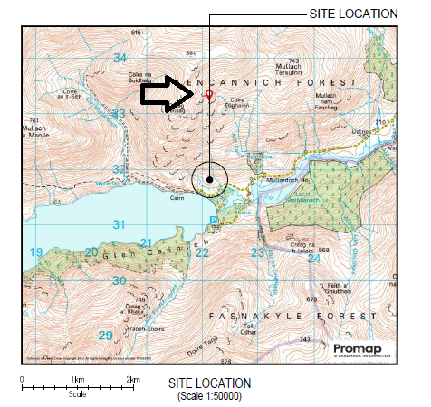
This post takes a look at the recent planning application – there are dozens more to come – for a mast at the eastern end of Loch Mullardoch to highlight some further implications of the Shared Rural Network programme.
The planning application
Due to a serious flaw in Scotland’s planning system, permitted developments like telecommunications masts do not require full planning permission in Wild Land Areas. They have to be notified to the planning authority, who can require the proposal to be modified but not refused. Unlike the proposed mast at the west end of Loch Mullardoch, however, the one at the east end is not just in the same Wild Land Area, it’s in an area protected for nature conservation and therefore requires full planning permission (hence the planning reference 23/04957/FUL). This means Highland Council could refuse the application and there is every reason to do so.
This application is not part of the Total Not Spot programme, fully funded by the UK Government, but part of the accompanying Partial Not Spot programme, funded by the mobile phone operators. The aim of this is to ensure that by sharing telecommunications equipment coverage for rural communities is not just limited to one operator, as is often the case at present. There is no explanation that I can find in the application of what area would be covered by this mast or why other existing masts could not be used to address “partial not spot” issues.
Moreover, Strathglass Community Council appears to have raised serious concerns, as the developer acknowledges in their “Supplementary Information”:
“To date we have only received contact from the local Community Council. On 14th September 2023, Strathglass Community Council Chairman R Humphrey Clarke sent his concerns over stating: “I wrote to you earlier on my own account. Having conferred with other members of our Community we heartily endorse the attached document [the statement from the coalition of concern about these masts] which spells out in rather more detail the points I made. In particular we believe any new masts should serve communities that exist rather than being geographically spread to meet an arbitrary percentage coverage of the nation. Our local area has been declared by the National Geographic Magazine as ‘The Best in the world 2023’ we therefore deplore the plan to litter it with industrial structures. If any of these masts is actually deemed to be necessary against the criteria of the attached document, may we please be given the opportunity to walk the site with your team and agree the detail of location, colour and concealment so that the beauty of this area is not destroyed.”
So far Highland Council has not published a single objection on the planning portal, either from Strathglass Community Council or anyone else (the application was validated on 4th November and the consultation nominally closes on 7th December). Two comments in support have been lodged, one from Digital Mobile Spectrum Limited, the joint venture between the four mobile phone companies behind the mast, and one from the UK Government:
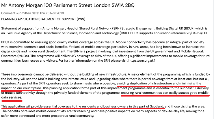 As the developer admits in their application there are “no nearby habited (sic) communities and the nearest habited (sic again) residence is 1.6 km away”. Mr Anthony Morgan, the representative of the UK Government, clearly does not know what he is talking about. His claim that the “Improvement” programme will minimise impact on the countryside is just ludicrous and illustrates just how far government is now prepared to go to support business interests at the expense of everything else.
That the UK Government, through Mr Morgan, has felt the need to comment on this application suggests they are becoming increasingly concerned about public opposition to these masts, both by outdoor recreationists and local communities. Their response is to try and railroad them through the planning system. The developer also appears to be doing the same:
“The financial constraints and time limits of the SRN project are also material planning considerations, as any undue delays or issues associated may result in the proposed sites cancellation and subsequent re-allocation of funds to fulfil another not spot area, leaving this area without mobile network coverage.”
While perhaps intended as a threat to the planners, the unintended implication is that if there is enough public opposition to this application the developers may well walk away. There are serious reasons to object.
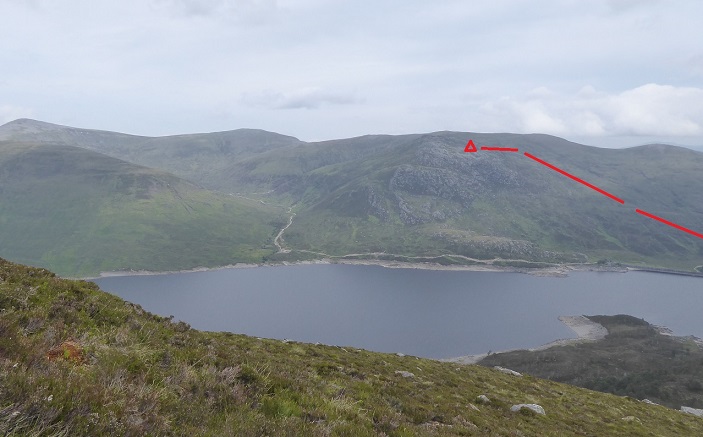
 The application appears to be an attempt to set a dangerous and very damaging precedent. The site location is far higher than most applications for mast to date at a height of c650m rather than lower down the side of the glen. Allow this and there could soon be telecommunications masts on some of Scotland’s great ridges.
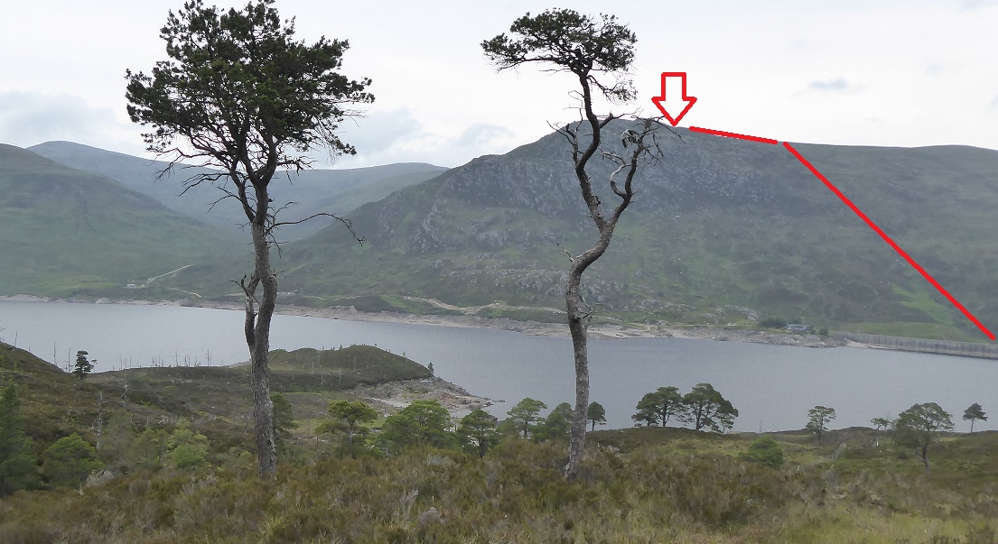
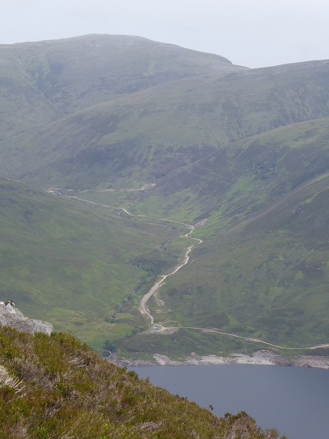
The application contains several vague statements about the importance of the landscape and how the developers are trying to minimise the visual impact of the mast which will be sited on a rocky outcrop more or less opposite the Munro Toll Creagach on the south side of Loch Mullardoch. The developer claims the form of the outcrop will partially screen the mast from view but predictably fails to discuss specific viewpoints (other than from the road). No landscaping is proposed “due to the steep terrain”.
The developer has not submitted a visual impact assessment or made any attempt to show from where the mast might be visible: the truth is unless it is visible from lots of places there would be no point locating it here as its coverage would be very limited!
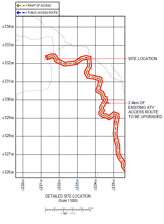
As part of the planning application a new 2.4km road is proposed up to the site of the mast. Again there is no attempt to consider the visual impact of the road – which is justified on the grounds that there is already a track created by ATV use up the hillside – but coupled with the horrible hydro track it will completely trash the lasts feelings of wildness at the east end of Loch Mullardoch.
Looking carefully at the full size original photo taken in 2019 I could just make out some ATV tracks heading up the hillside but their visual impact is nothing compared to what would be a 3m wide scar up the hillside. The “design” of the proposed road is contained in the “Access Layout” document and is not fit for any purpose:
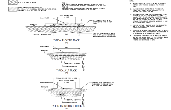
Showing “typical” sections of a road tells you almost nothing, apart from the fact this road will be 3m wide (on the “narrower” straight sections). There has been no survey to show much of the track will float on peat more than 1m thick nor how much peat less than 1m thick will need to be excavated to create the road. Moreover:
“Materials are yet to be selected; this will come with final build design further to a full access survey. Likely build materials are to be two wheel lines of compacted stone with existing ground maintained in between.”
To complete the shambles the Design Statement also says the developer has “instructed” an ecology report, although as yet there is no sign of this on the planning portal.
The site is on the Glencannich Estate who were notified by the developer of the proposed development on 13th October. The estate, which Who Owns Scotland shows is owned by Sir James HF Fuller and Edward RF Fuller, do not appear to have responded as yet. If they objected to the application, as the National Trust for Scotland has now done in Torridon, and refused to provide their consent to build a road on their land, that would make a difference. How much the Fullers care the landscape for which they are the custodians, however, is a moot point:
The hydro scheme should not be seen as a justification to add to the landscape damage in Glen Cannich, rather a compelling reason why Highland Council should NOT allow another road to be constructed on the other side of the ridge on the right
Why objecting to this application is important
The only justification for this application is that it will improve mobile coverage for hillwalkers and other outdoor recreationists. The “Supplementary Information” states that: “the majority of those viewing the (mast) would be those taking part in recreational activities, and perhaps the occasional estate worker, which is an extremely limited number of people”.
The developer clearly doesn’t have a clue about what is important to the outdoor recreational community or what people do. There are poorly informed references to “trails” – presumably meaning the circuit of the north Mullardoch Munros and the round trip of north/south Munros – the importance of which is brushed aside with statements such as “the routes to complete this loop are very difficult and accordingly are only used by a limited number of people”. Why not then listen to those people and the organisations that represent them?
For those who value wild land and Scotland’s remote landscapes, being “away from it all” and out of mobile phone signal is part of what of what is valuable about the experience. For others who enjoy being outdoors but also like to use their phone, the question they should ask themselves should be what is more important, being able to send photos with a couple of clicks from where-ever one happens to be or the subject of most of those photos, the unspoiled landscape?
For a popular campaign against these masts to success we need lots of outdoor recreationists to get behind the coalition against the masts and say “not in my name”. Please consider doing so for this application for the reasons explained above. You can comment here where here is a link to register with Highland Regional Council – a simple process – if you have not already done so.
[I would like to thank Jane Meek, who alerted me to this application and highlighted a number of statements which I have quoted, for her help with this post].

Anyone interested in commenting on this application might like to know that the mast location falls not just within a WLA, but also within a Special Protection Area (designated because of golden eagles), a National Scenic Area, a National Nature Reserve and a SAC (which I think is Special Area of Conservation). There is to be an off-grid generator – fossil-fuel driven, one assumes, with attendant noise and stink. The mast may also require a red light, although I don’t recall seeing this specifically mentioned in the documentation. At 650 m of elevation, one might assume so. I think the crowning indignity is the developer’s comment to the effect that the hillside is likely to be shrouded in cloud more often than not, as though that negates the visual blight!
I’d also like to alert readers of this blog to another mast application, this time for Rannoch, which is Perth and Kinross. The planning ref. is 23/01656/PNT and the deadline for comments is 13/12/23. Presumably this one “cannot” be refused. I saw it listed on the JMT website but I haven’t looked at it yet, so who knows – perhaps this one is in a sensible location!!
I have commented on this planning application.
There was a Holyrood question rased – see below.
Foysol Choudhury MBE MSP
Member of the Scottish Parliament for Lothian Region (Labour)
Question
To ask the Scottish Government what action it is taking to ensure that the implementation of the Shared Rural Network plans consider the most appropriate locations to place 4G masts for public benefit, in order to not unnecessarily damage wild land.
Answer
The Scottish Government has no formal role in the Shared Rural Network (SRN) programme which is a joint venture between the UK Government and the UK’s four main mobile network operators.
However we fully recognise the need to ensure that SRN deployment in Scotland is maximised whilst being cognisant of the importance of Scotland’s natural environment. In order to improve communications between SRN programme leads (both UK Government and industry) and key Scottish stakeholders including the National Parks and NatureScot, we have organised and participated in direct discussions with these parties. We encourage the SRN programme to explore these issues with all relevant stakeholders through improved engagement and to determine mutually acceptable outcomes.
We have also shared with the SRN programme our experience and learning gained from our Scottish 4G Infill programme, which has deployed 55 masts to serve rural and island communities. This learning includes the importance of thorough local stakeholder engagement at the mast site selection and acquisition stage.
There is more to this than rural connectivity…I suspect the UK government is also thinking about surveillance and security ‘benfits’ of such installations
Well written Nick. Regarding the altitude of mast sites, I don’t want to cause fear and alarm but in the post below, the SRN boasts about the heroic struggles of survey teams:
“Locations on the top of Munros led to more of a hike than a walk,..”
https://srn.org.uk/the-challenges-faced-whilst-looking-for-srn-mast-locations-draft/
Perth&Kinross application 23/01656/PAT is, for once, well documented. SITE SPECIFIC SUPPLEMENTARY INFORMATION has a painful, logical, explanation of how Wild Land is under systematic attack
“The overall Total Not Spot element to SRN will see an indicative 320 new sites proposed across Scotland and these have been divided between the 4 MNOs, with each being
tasked with delivering around 80 sites each.”
“The rational for (this) SRN is set out above and OFCOM provided the MNO with the TNS areas where coverage is required. They are also provided with nominal locations which radio
software has determined will provide coverage across the area to the required level.”
SO: The developers are putting the masts where Ofcom tell them to. They choose and (if they can be bothered) justify the site as the best one which can be found which fulfills the Ofcom Requirement.
Yes, I read that bit about struggling over Munros and was duly alarmed. And yes, the Rannoch application is “properly” done, for once. If I didn’t know better, I’d say this was a concerted and systematic attack by government (?) to wipe all trace of naturalness from the planet.
David, this is really helpful, thank you – I will forward it to members of the coalition against masts, Nick