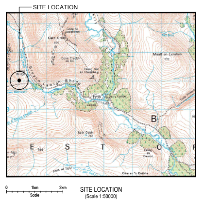
An application (link here) to erect a 20m digital communications mast adjacent to the Luibeg footbridge and the paths to the Lairg Ghru and to Coire Sputan Dearg has been called in by Cairngorms National Park Authority (CNPA) for a decision.
Background to the Luibeg application
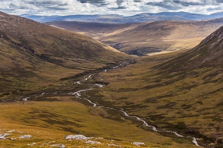
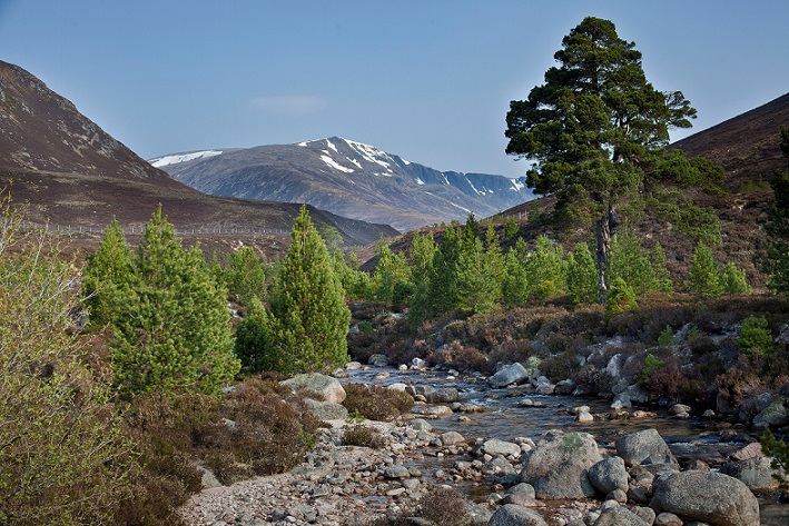
As readers of Patchwatch will know, this area is an ‘inner gateway’ to the very centre of the Cairngorms and to some of its finest corries. In landscape terms, it is of national importance, so why is a visually intrusive mast being proposed here?
The Shared Rural Network, developed by four UK network operators, is a UK wide scheme mandated, and part funded, by the government. It aim is to deliver 4G coverage to 95% of the country, thus ‘enabling rural businesses and communities to thrive‘. Implementation has been given over to commercial companies to deliver, without, it would seem, any guidance from the government on the implications for sensitive landscapes. The companies map ‘not spots’ where coverage is limited or occasionally non-existent and submit applications to the relevant planning authorities, which are left with the unenviable task of sorting out the conflicts between improving communications and defending landscapes.
Landowners who do not want masts on their land have no legal rights to ‘refuse’ their erection.
This year has seen a rash of applications across Scotland, many of them in sensitive areas where they they will, if approved, be blots on unspoiled landscapes. The North East Mountain Trust has commented on, or objected to, a number of proposed masts in the Grampian area. The applications themselves have almost all been of very poor quality- ‘cut and paste jobs’ lacking site specific and other essential information. Many, if approved, will have limited value as the areas they cover have no, or almost no, permanent habitation.
Key issues related to the Luibeg mast
- In landscape terms it would have a highly detrimental visual impact on a Wild Land Area which is also covered by numerous statutory designations aimed at protecting it. The application acknowledges that the visual impact cannot be mitigated for.
- The mast would have very little public benefit. The application states that the mast would benefit economic activity including farming and tourism and adds that ‘local businesses in the area could reap the benefits of improved connectivity for sustainable growth, higher economic profits, and essentially a higher quality of life’. This is misleading. There is no farming in the area and no businesses (Mar Lodge cannot be characterised as such). Indeed, it can be argued that ‘the quality of life’ of those who visit the area would be diminished by the visual intrusion of the mast in such a wild landscape. It is stated that the population is very small when, in fact, there are no permanently inhabited buildings at all in the area. An example of the cut and paste approach which characterises these applications.
- The application states that connectivity ‘can improve upon people’s experience when exploring the Park. There are several online OS maps and mobile applications — that are highly valuable resources to assist walkers in navigating trails. None of the mobile operators currently serve this area, which includes no emergency service presence, and therefore improved coverage would only improve upon hiker’s overall experience and safety’. Firstly Ofcom mapping shows that much of the area is already covered by cross-network emergency call coverage. Secondly this statement contradicts the advice given by mountain rescue teams which is that mobile phones should be kept on flight mode when in the hills to conserve the battery and to prevent the partial updating of relevant apps if a person moves in and out of connectivity. In addition, NEMT understands that many apps are downloadable and do not require coverage for use. Mountain safety experts continue to insist that those going into the hills should consider a mobile phone as back-up only to the main navigation tools of map and compass.
The siting of a mast at Luibeg conflicts with the CNPA’s Statutory Aims and its Local Development Plan and with Scotland’s National Planning Framework 4 [which was approved by the Scottish Parliament] in a number of ways.
Incompatibility with the National Park’s Statutory Aims
While the CNPA has a duty ‘to promote sustainable economic and social development’, this is overridden if it conflicts with its aim ‘to conserve and enhance the natural and cultural heritage of the area’. This raises the issue of public benefit versus the environment, in this case landscape. The area in question is amongst the finest in the Cairngorms and the public benefit would be negligible, therefore the Park’s over-riding aim must take precedence.
Incompatibility with National Park’s Local Development Plan
Policy (6b) on digital communications equipment states that equipment will only be permitted ‘in sensitive areas (where) detailed evidence demonstrates that the proposals would not lead to unacceptable effects on areas of particular ecological interest or landscape importance—.’
Incompatibility with National Planning Framework 4
Policy 4 (Natural Places). The relevant sections are
- a) Development proposals which by virtue of type, location or scale will have an unacceptable impact on the natural environment, will not be supported.
- c) Development proposals that will affect a National Park, National Scenic Area, Site of Special Scientific Interest or a National Nature Reserve will only be supported where: i. The objectives of designation and the overall integrity of the areas will not be compromised; or ii. Any significant adverse effects on the qualities for which the area has been designated are clearly outweighed by social, environmental or economic benefits of national importance.
- e) The precautionary principle will be applied in accordance with relevant legislation and Scottish Government guidance.
- g) Development proposals in areas identified as wild land in the Nature Scot Wild Land Areas map will only be supported where the proposal: ii) is for small scale development directly linked to a rural business or croft, or is required to support a fragile community in a rural area.
Policy 24 (Digital Infrastructure) While supporting national roll-outs, Policy 24 adds the following caveats d) ‘Development proposals that deliver new connectivity will be supported where there are benefits of this connectivity for communities and the local economy’. As demonstrated above, there no significant benefits in this case. e) Development proposals for digital infrastructure will only be supported where: i. the visual and amenity impacts of the proposed development have been minimised through careful siting—.’ As acknowledged by the applicant, it is not possible to minimise the visual impact in such a sensitive area.
This is test case. The integrity of the central core of the Cairngorms, unarguably one of Scotland’s finest landscapes, must be protected.
For people wanting to object to find application either click here or go to- https://cairngorms.co.uk/planning-development/ click on ‘View planning applications’ and enter Application number- 2023/0364/DET; then to object click on ‘Comments’ on the bar.
The closing date for objections- 16th October
(George Allan on behalf of North East Mountain Trust SC008783)

It’s a spoof, surely! I know the area well and I can’t think of a more inappropriate structure and proposal for such an area!
Well if they can do what they’ve done in Coire Cas, this is diddly squat in comparison. The joke is on us all
I too though this was an April Fool, until I looked at the calendar. But it’s real. My objection is in.
I know the area well. Derry Lodge is the mountain rescue post and is served by a road while having a communications post. I don’t see any need for communications masts beyond that point. These are precious lands.
5G needs more/higher masts and the UK Gov has been consulting about this for years. The result is as expected – forcing through the rollout to suite the telecoms companies, so they can claim xx% of coverage as required by their licences (issued by the same UK Gov). As with most other things, the UK Gov serves England’s priorities and cares little for the Highlands of Scotland – that’s not where their core voters live, whether Labour or Tory. So there’s little Scot Gov can do whilst telecommunications remains a matter reserved for the UK Gov.
It’s interesting to review the UK Gov’s existing Code of practice, which considers both protection of visual amenity and mitigating visual impacts – where is the evidence that either of these are being considered in these applications?
In more detail the CoP states:
Protecting visual amenity: a comprehensive assessment of the area should be carried out to ensure that the design solution appreciates the context of its location by fitting with both the site and the wider setting. Proposals should take into account protected sightlines, landmarks and vistas. This is particularly important when mobile infrastructure is located in protected landscapes or heritage sites and their settings.
Mitigating visual impacts: when possible, operators should look to use sympathetic designs, materials and colour (including camouflage where appropriate) to minimise the contrast between infrastructure and the area. Operators should also consider the design principles set out in the NPPF and local planning policies, and consider any relevant local and national design codes.
Of course if the mast really must be constructed in an intrusive location, options exist to camouflage it – including making it look like a tree!
This is horrendous. Imagine if the sycamore tree beside Hadrian’s wall had been felled to put up a Telecommunications mast. This is on a parallel with that!
The application looks so blatantly silly that we need to look for some underlying motive. I think the motivation is to acheive a UK government target of 91% coverage of land area of the UK with a 4G service. This is intended to improve communications for rural communities, itself a laudable aim. However, the target isn’t aligned properly with the laudable aim. So progress towards the target can be made by providing a 4G signal in an empty area, with no rural communities at all. I think that this is what’s happening here.
I think that it would be good to attack the broader issue, as well as the immediate nonsense. The Larig Ghru isn’t the only place at risk.
It’s a UK government initiatve, but maybe the Scottish Government could be persuaded to take an interest: “hey, you’ve got a good idea, and you’re providing money for it; but better value for money could be got in Scotland by refining the target to 91% of rural communities rather than 91% of land area. I’ve written to Lorna Slater suggesting this, but the more folk and organisations which do, the better.
Inappropriate and unnecessary vandalism.
Outrageous disregard for environment, and goes against everything a National Park “should” represent.
Given previous form, I have to ask if the Cairngorms National Park Authority has seen a profit in it.
Some of my greatest times have been exploring this wonderful place ! Absolutely disgusting that any money grabbing phone company should be allowed to violate this totally unique area . I for one will make sure this monstrosity after its completion will never work !!!!!!
The good news- the application has been withdrawn. North East Mountain Trust understands that this is partly because of the very large number of objections. Thank you to everyone who objected.
The bad news- It is likely to be resubmitted in the not too distant future providing more info and possibly siting it in a slightly different location. It will be a new application and people will need to object all over again.
Wow. I object of course. That’s a ridiculous idea.
Watch out for them trying to sneak it through unnoticed a second time! I wonder if they have a legal obligation to contact the public or the objectors about their second attempt (or if their second attempt has a much shorter window of opportunity for us to object)?! Sometimes planning things can appear to sneak through on the second attemp, and everyone finds out it’s gone through before they can object or protest again.
Unfortunately the Cairngorms National Park Authority in past cases has said it would not notify objectors when an application is re-submitted (this came up in respect to the Pitmain Hill track) and is under no legal obligation to do so. That is one of the way that Scotland’s system has been deliberately stacked in favour of developers. Also important to note that developers incur no fee when the they re-submit an application (though the fee in this case – I have checked with the CNPA – was paltry (c£500).
Can I highlight this part of NPF4, quoted above:
“g) Development proposals in areas identified as wild land in the Nature Scot Wild Land Areas map will only be supported where the proposal: i. will support meeting renewable energy targets; or, ii. is for small scale development directly linked to a rural business or croft, or is required to support a fragile community in a rural area.”
This could be our strongest card, because it is is unambiguous: no caveats. And it applies to all wild land, not just the Parks.
In case folk have not noticed, the mast is powered by a 10kW diesel generator which burns ~1 litre of fuel per hour or 150 litres per week.
Presumable this means an ATV grinding its way up the path every fortnight. In winter.
Complete desecration of a wild area. Derry Lodge MR post is close by. Must be defeated.