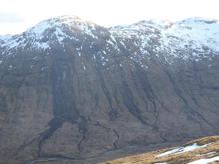
On Sunday I went for a walk in Balquhidder, which I had not visited since a beautiful day just before lockdown in 2020 when people were being advised to stay at home. On that day we came across just one person but we did see from close up the multiple land slips on both sides of the glen which had been triggered by the “extreme” rain event in August 2019. Balquhidder appears to have been at the centre of the downpour which caused landslides and flooding in Glen Falloch to the north (see here) and Loch Katrine to the south (see here).
While the heavy rainfall on Friday was not reported to have been quite as extreme as three years ago, I was keen what impact it had had and to combine that with a hill walk.
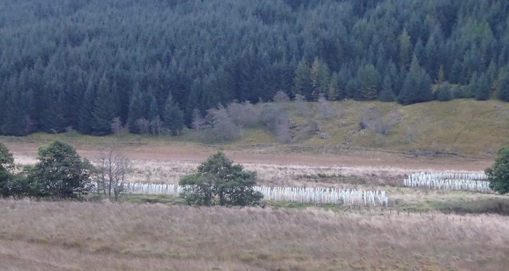
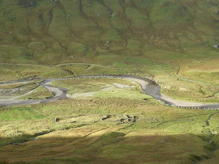
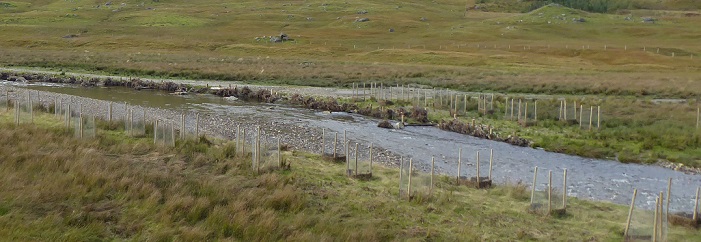
We were greeted by a forest of plastic tree tubes on the flood plain just before the road end at Inverlochlarig which the Loch Lomond and Trossachs National Park Authority (LLTNPA) had boasted about back in March (see here). The photo illustrates how the LLTNPA has paid no regard to the landscape, carbon emissions – plastic is derived from oil – or how it is killing wildlife in our rivers and seas.
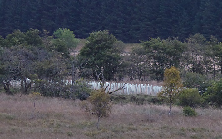
The LLTNPA stated the purpose of this tree planting was to improve river habitats by creating riparian tree cover. This photo shows it was completely unnecessary and a waste of public funds. There are already lots of trees along this section of the River Larig and these would regenerate naturally if given a chance. .
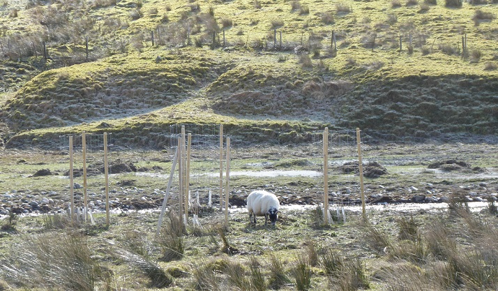
The reason that the River Larig, part of the River Teith Special Area of Conservation, is in poor ecological condition is because of the level of sheep and deer grazing in the glen. This has had consequences not just for habitats but also flooding and landslips. Under the current system, landowners are allowed to continue with high levels of grazing, while the state helps pay to fix the damage with yet more postage stamp sized planting (see here). Our National Park Authorities should know better but have become part of the problem.
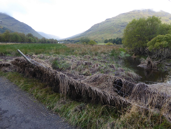
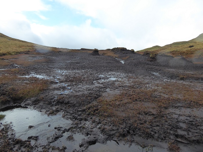
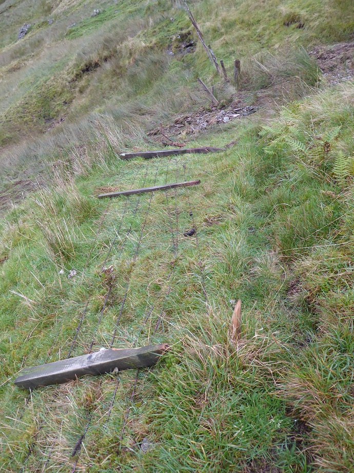
Just 50m beyond the car park, we came across evidence that the rain on Friday had been sufficient to cause significant flooding
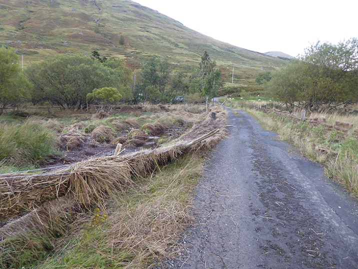
Even small scale damage like this will have caused significant cost to the landowner
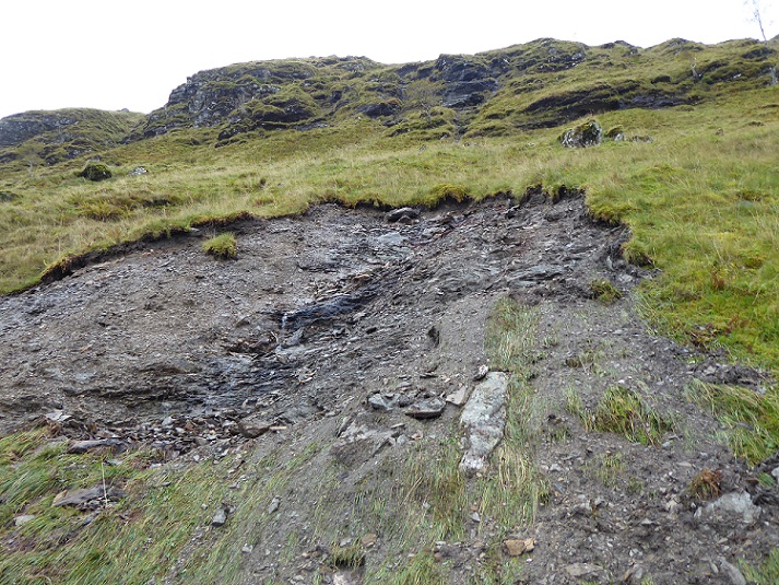
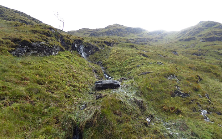
Once on the hill – we traversed Stob Breac and Stob a’ Choin – we did not see further signs of flood damage until descending back to the glen but we did see some areas of significant peat erosion:
This and other areas of degraded peatland between Balquhidder and Loch Katrine could be helping to absorb rainfall which has been triggering landslips on both sides of the watershed. This particular area would appear need very little restoration work to start functioning again as a bog. If grazing levels were reduced, the flat areas would quickly re-vegetate with cotton grass. The other main intervention that would be required would be to block up the water course and create bog pools.
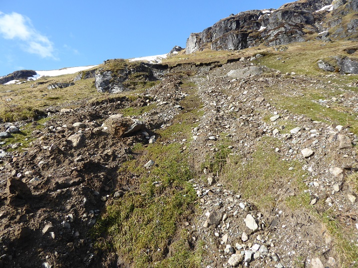
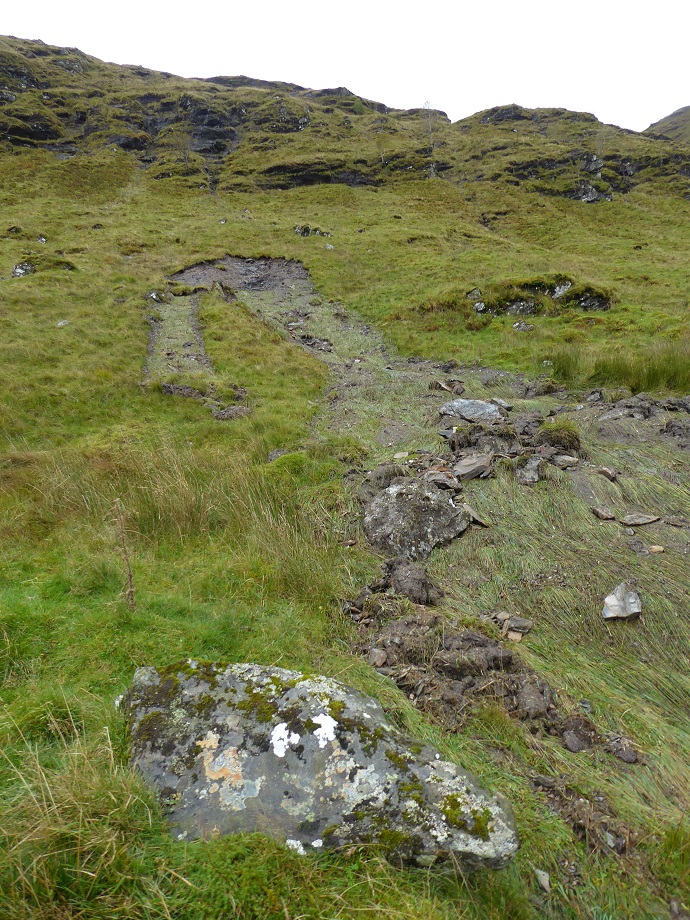
We chose to descend Stob a’ Choin from the Bealach Coire an Laoigh (pass of the coire of the cattle), a more difficult route than it name implies, and after threading our way through the crags came across a new landslip:
A small watercourse was visible below the crag above the landslip which then disappeared under the vegetation. It appears that the volume of water flowing down this underground burn triggered the landslip exposing the burn once more.
There was also enough water running down the hill to allow these blocks to slide over the vegetation without causing it significant damage
The landslip continued scattering debris for several hundred metres down the hillside
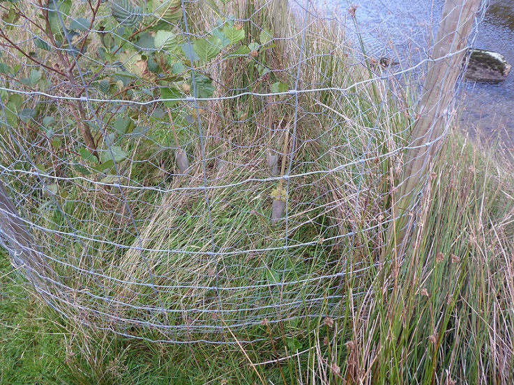
The force of the water and the debris it was carrying was sufficient to flatten this stock fence well below and snap one its posts in two – more costs for the estate
And finally this large boulder freshly deposited on vegetation. How far was it carried?
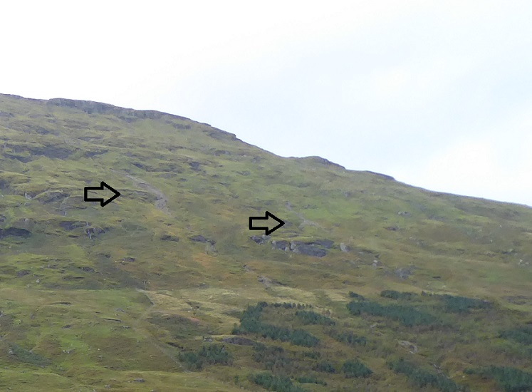
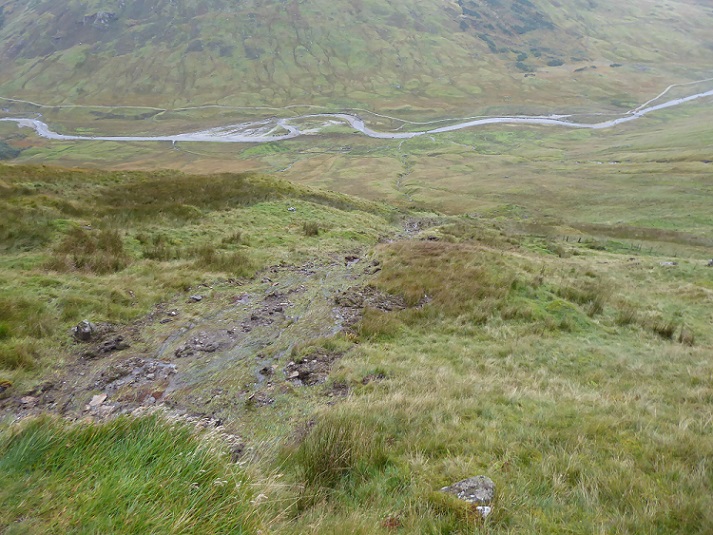
Looking across and up the glen we could see a number of other signs of recent landslips, not as large as in 2019 but an indication that what we had seen was an example of a much wider problem.
Down in the glen below, there has been extensive tree planting along the river banks. The primary purpose of this appears to be flood protection, not habitat improvement, as it has been accompanied by work to protect the river banks.
Some of the enclosures, particularly where broadside on to the flow of water, had taken quite a battering in the flood.
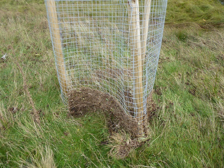
While there was no tree surviving in this enclosure, the way the wire serves to catch the vegetation probably helps to protect the trees and reduce the chances that they will be uprooted by the force of water or chopped or crushed by flood debris (though alder have evolved to survive such challenges). A larger flood, however, might destroy the enclosures and the trees with it.
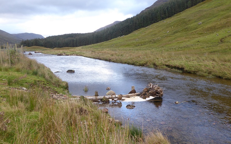
Placing tree trunks across rivers is now quite fashionable in conservation circles. While it serves to hold back some debris, potentially creating spawning beds for fish, in a flood it is likely to quickly bank out so that water and debris flow over the top. Neither in-river works like this nor planting trees is likely to reduce flood flow significantly.
 Once water is in the river its too late and the only real option in terms of natural flood prevention is to let the water spread out over flood plains.
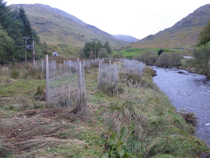
Two and a half years ago many of the tree enclosures above Inverlochlarig were still in the process of being constructed but many of those that had been planted then have had three seasons to grow and are doing quite well. What this will achieve, however, is another matter and in my view far from the landscape scale conservation we need in Scotland.
What needs to happen
If we are to address the climate and nature crisis in our National Parks and Scotland more widely, focussing attention on woodland planting along rivers alone, as is happening at present, is not going to achieve very much (I hope to write soon about further woodland planting in the River Geldie and Glen Banchor in the Cairngorms National Park). If we could enable extensive areas of natural woodland to regenerate on the hillsides, however, that would make a big difference. In terms of flood and landslip prevention, for example, each tree or dead log would serve to hold back a little water and in total that would be significant. In the longer term woodland regeneration would contribute to the development of soils that might help absorb even more water.
But we need to enable other vegetation, including that which helps create bogs, to recover too.
Landscape scale conservation cannot happen until we reduce the levels of grazing in upland areas drastically. Fences and tree tubes are just a symptom of the failure to tackle the grazing problem.For this to change we need to replace the current rural payments system, including grants for tree planting, so that landowners are rewarded for keeping the numbers of grazing animals low or confined to fence areas and not if they don’t.
I have every sympathy for the people who own and work at Inverlochlarig and similar farms. They need to earn their living. But, if they continue to do so as at present, they are the people most likely to suffer directly in the long-term, whether this is being caught in a flood or seeing the soils on which their farming operation depends being washed away. Its in their interests to keep rural subsidies but use them in radically different ways.

I was at Derry Lodge a few weeks back. It was the first time I had been back for a few years, various reasons (looking after elderly mother, illness etc), and I spent the whole ride out and back marvelling at the new growth. There were trees everywhere, trees where none had been since my first camp there in the 70s. At the Derry burn there were trees shooting up on the river bank, and I could see they were colonising the hillside further up. No plastic tubes. No deer. No sheep.
Hi Donald, yes the north west side of Mar Lodge Estate is absolutely fantastic. Visit the south, however, along the Geldie and its another story which I intend to write a post about soon: far too many deer, deer fences round planting, plastic tree tubes used to plant trees on deep peat. Nick
While, it’s an auld lament that we’ve heard all too often in the past and it needs a change of tune at the national strategic level, but the ‘conductors’ of the orchestra don’t seem to give a hoot or a toot about it and the VED continues.
We need the strategic planting to start at the upper limit of tree growth and then work down hill.
Nick, Something you failed to mention is that the landowner has had at least 250,000 trees (low estimate) planted throughout the glen not in the riparian corridor, including recent additions this year further up the hill-sides at a higher altitude than the one pictured. I don’t condone the way the land is currently managed at all, especially the impact that herbivores are having on the landscape, however without painting the whole picture your post is not wholly honest or representative of this site.
In terms of the works carried out in the riparian zone including the use of large woody structures, these were carried out purely for biodiversity purposes and not “flood control”. As the main point you put across rightly makes, the only way to attenuate run-off from the hillsides and reduce flooding (and decrease the chances of landslides in the process) is with increased tree cover and peatland restoration, particularly in a system like the Larig. I also don’t defend the means by which the trees are planted in the riparian zone, which were a compromise of restrictions placed on the works from multiple angles, but they were the only way to introduce trees to areas of the site which will not see natural regeneration in the way the land is currently, and how it will continue to be for the foreseeable future, managed.
This river, among countless others, is facing pressures as a result of a lack of riparian habitat. Lack of shade in soaring summer temperatures, eroding exposed river banks lack of nutrient input and lack of habitat for aquatic and terrestrial river species are something the works seek to address in small part, working within the confines of a restricted site. From posts of yours I’ve seen before I feel you’re aware of this info already, but it did not fit your overall narrative for this piece regarding landslips and flooding. I fundamentally agree with your wider point of landscape scale change needing to occur, and I would much prefer to see conservation funding spent in a more cost-effective manner. However, on sites like this that are the result of hundreds of years worth of same-minded management, something has to be done to try and address the issues facing these habitats, before legislative change can pave the way for a better environmental future on the scale at which your argument preaches for.
Thanks for the comment and the really helpful information. I had not intended to provided an overview of what is being done on the estate. Unfortunately, not just in Balquhidder but across Scotland it is very difficult to find out what is going wrong so its very very hard to find forest plans on the Scottish Forestry website, for example, while NatureScot’s Sitelink on protected sites is full of information that is very out of date. If there is information publicly available about this planting I would be very grateful to be pointed towards it but you have filled a gap. In my view, however, there is still a massive failure in joined up thinking, so nature restoration is separated from trying to adapt/mitigate the impacts of climate change. While I accept that conservationists are working in vary difficult circumstances, I don’t think your claim that we need to wait for legislation to change the way the land is managed is correct. We could change the Scottish Forestry system now and stop providing funding for plastic tree tubes and pocket sized enclosures and use it to improve current practices. My next post takes this point further. I welcome a debate on this. Nick
I recall going around the Western Highlands on my climbing ramblings after the floods of 2014 and seeing widespread and indeed, in some places, spectacular landslips on hills. To a considerable extent It is inevitable as one impact of climate change. It is noticeable also how screes in many places have reactivated – as in Glen Clunie. This happened widely from the Pentlands to the Highlands in 1978 during a prolonged wet period. There surely is needed a twofold response. One is to identify places where landslips would have a serious impact like the Rest and Be Thankful and take action to stabilise the slopes. I have done study tours in places like the Alps where slope stabilisation is a well-developed skill. One guy there wrote a handbook on it and the Canadians had it translated into English because they thought it so important. I worked with the Environment Agency in the Lake District and the main guy I worked with there had led a project in which, many years ago, every vulnerable slope in the whole Lake District had been identified and they then obtained a grant from the Lottery that funded all of these slopes being planted up. I find it astonishing that the slope above the Rest and Be Thankfull has not been planted up – as I gather from the above entry. The other thing that needs done is to assess how the vulnerability of areas to flooding etc is being influenced and this needs an integrated catchment approach. I did a lot of work on this here and abroad and that is the approach that is supposed to be required under law in Scotland.
Aye Drennan, as you know Derek and I sing from the same hymn sheet as you do on this and have had discussions on the subject at Holyrood with the then Transport Minister as well as other government ministers–but nothing concrete ever emerges–apart from concrete. We cover some of this in andywightman.com.archives/3291 and Derek features the issue in his recent presentation at the Orkney Fire Festival ( available on youtube and facebook ( Rewilding Scotland)