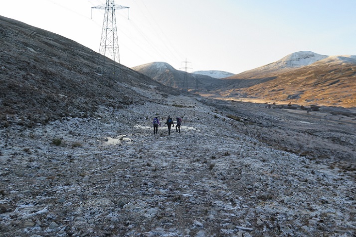
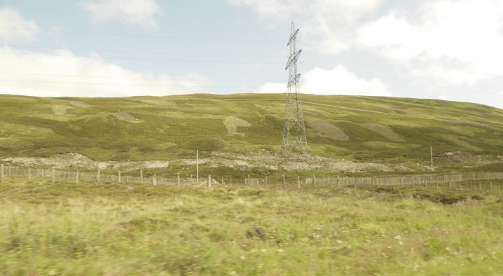
I have not blogged about the destruction caused by the Beauly Denny powerline construction since last July (see here). But each time I cross the Drumochter the scars left by SSE (formerly Scottish and Southern Electricity) appear just as bad and I have been meaning to go back and take a closer look at how the “restoration” is going.
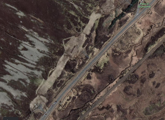
An article on the A9 in the Herald magazine on Saturday (available here) was accompanied by a aerial photo looking south towards the Sow of Atholl and the summit of the Drumochter pass. The photo was taken just above the Beauly-Denny powerlines and provided not just a view of the A9, the railway and the River Truim but also of the impact of the construction. It is worth a look. The photo, however, was undated and could have been taken a few years ago, which prompted me to take a look on Google Earth:
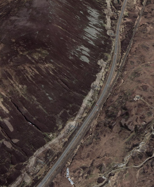
I wished I had thought of doing this before! It clearly shows the extent of the destruction and that restoration hasn’t worked!
Regular readers will recall that the Beauly Denny was constructed through the Drumochter Hills Special Area of Conservation, supposedly one of Scotland’s most highly protected sites, and granted planning permission subject to the ground being restored to how it was previously. SSE announced the construction project was complete in July 2015, almost seven years ago.
Having granted the planning consent, the Scottish Government devolved responsibility for enforcing its own planning conditions to the Cairngorms National Park Authority (CNPA), while at the same time doing nothing to help them sort out the mess on ground (see here). In August 2015 SSE wrote to the CNPA Convener, absolving themselves of responsibility for what had gone wrong – they blamed thin soils rather than poor construction techniques – but committed to continuing to work on restoring the site:
SSE in fact had no choice about this because condition 31(a) of the S.37 Consent for the Beauly Denny required that:
“the applicant (ie SSW) shall, in carrying out any activities associated with the construction of the
overhead transmission line and the dismantling of the existing 132kV OHL, implement all
construction methods, mitigation proposals and restoration measures detailed in that Final
Report (Drumochter Hills Special Area of Conservation Habitat Restoration Final Report dated 26 June 2007).
And that report clearly stated:
“All temporary tracks used for construction of the new line will be fully restored [my emphasis] within 15 years from the start of construction”.
Based on the aerial evidence, at this rate of progress that is never going to happen unless the Scottish Government, NatureScot and the CNPA force SSE to do so.
With SSE forecasting profits of almost £1bn from soaring gas prices (see here), they have no excuse for not doing so. They could easily afford to employ expert landscapers, ecologists and contractors to restore the ground to its original condition instead of dragging their heals as they appear to have been doing the last seven years. The question is whether there is any political will in Scotland to hold the big energy companies to account even in our National Parks?
On Friday the Scottish Government Minister responsible for National Parks, Green MSP Lorna Slater, claimed they “have become jewels in Scotland’s crown?” If she took the time to look at the state of the land on Google Earth, perhaps she would stop making these rash claims and focus instead on what has been going wrong in Scotland’s National Parks?.

deer and sheep can access the site and the plants growing on the mineral soils must be very tempting. Needs to be properly sheep fenced at least
Hi Ron, you are absolutely right about this, grazing animals are immediately attracted to plants growing on mineral soils. Part of the area along the Drumochter has been surrounded by fencing to try and address this issue. I have been meaning to return to look at it more closely. Regeneration on site will also not be helped by muirburn, which besides the damage it causes creates more new growth attractive to grazing animals and adds to the challenges. But the planning conditions also required the landscape to be restored to how it was and that hasn’t happened, with the great shelf excavated by the track through the moraine left unrestored. That has fundamentally changed the drainage of the site and along with the exposed mineral soils the entire ecology of the site. If plants do eventually regenerate they are likely to be significantly different to those for which the site was designated. Nick
indeed, and going through the VEDscape doesn’t help either. Both the A9 and railway embankments show what can happen if protected from at least sheep grazing. Any linear woodland would have to be managed not to compromise safety maintenance, but shrubs should not be too problematic and would give benefits in terms snowdrift protection and carbon off-setting.
and they couldn’t bury the cables ‘because that would scar the landscape’…..
Thought I’d read that burying the cables would double the cost, yet they said that what they’ve constructed would only add £10 to everyone’s bills. Very economical use of the truth?
And we are now paying to bury cables in the Loch Lomond and Trossachs National Park by Loch Sloy and in Glen Falloch and Glen Dochart. There is no joined up thinking on the part of government
A similar problem arose in the LLTNP in Glen Fruin where a wide track was constructed to help with the renewal of the power line. Restoration was required but a compromise was reached whereby the track would be retained as an off-road section of the Three Lochs Way and a Bridge constructed over the Burn to link with the road along the Glen . Luss Estates applied for planning permission for the Track and Bridge and, given the benefits of both an off-road route and a circular path around the Glen, it was approved. Five years later, when it became obvious that the bridge was not going to be built, enquiries were made to Park Planning. It then became clear that a mistake had probably been made in not making building the bridge a condition of the planning and nothing could be done to enforce it. The Chief Planning Officer at the time is now the Chief Executive of the Park.