In the early hours of Sunday, only six days after it was re-opened (see here), the A83 was closed after another landslide on the slopes of Beinn Luibhean (see here). The BBC report stated there had been 75mm of rain in 24 hours. Then yesterday the West Highland Line was closed between Bridge or Orchy and Tyndrum, also in the Loch Lomond and Trossachs National Park (see here).
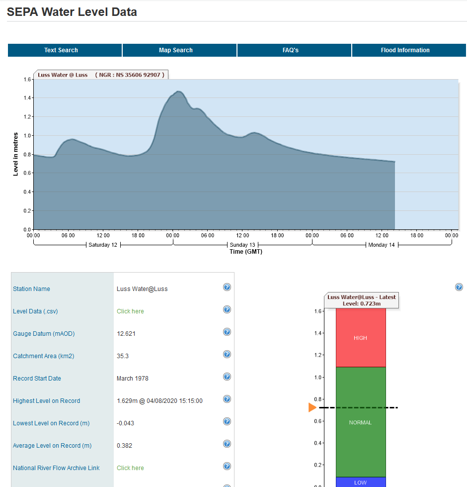
The nearest SEPA water level monitoring station (see here for all stations) to the Rest and Be Thankful is at Luss and it recorded water levels only about 18cm below the record. That was set just last month,on 4th August 2020.
One of the changes in weather caused by global warming is that as the seas heat, more water evaporates into the atmosphere and more then descends as rain. Where, depends on the wind, but the heating of the Caribbean, the storms generated there at the end of the summer and the increasing number of extreme rain events in Scotland all appear connected. They are likely to continue as long as the prevailing south-westerly winds continue. As a result, in recent years I have learned not to stay away from the west coast of Scotland in late summer, although there are the occasional good days between the downpours.
Extreme rain events appear to be the main trigger for landslips all over the world (for great video of recent landslip in south India see here). The flash floods they cause also have a considerable impact on rivers and structures associated with them, from bridges to hydro schemes. SEPA’s water level monitoring stations show that a number of other rivers to the north of Arrochar also reached near record levels on Sunday, including some close to the West Highland Line landslip:
- The Lochy (Argyll), to the north, was 15cm off its record height set back in 1978
- The Strae, by Cruachan, was 10 cm off its record set in 1999
- The mighty Orchy, at 3.6m, was only 30cm off its record level set back in March 1979 when snow melt is likely to have been a factor
- Victoria Bridge was about 20cm off its record set in 1989
Interestingly, the River Falloch was not quite as high, only 2.4m compared to the record levels of c3.1m set last August and further east, in the Trossachs, rainfall was within “normal” levels. The most intense rainfall therefore appears to have been to the west and north of Loch Lomond. It would appear reasonable to assume that in the area most affected there will have been further landslips and examples of damage caused by flash floods.
Unfortunately, however, in Scotland we have no means of reporting and monitoring the number of landslips that are occurring or the damage that is being done. We have a national system for monitoring the impact of floods, which is used to inform the planning system and prevent development in areas at risk of flooding, but no equivalent system for monitoring landslip risk or its impacts. While individual landowners and managers will know about landslips, and where they have hydro schemes, for example, be aware of the volume of material that is being washed off the hill and down our rivers, no-one is looking at the big picture. The Loch Lomond and Trossachs National Park, which is particularly affected by high rainfall, could have a key role in articulating the need for this.
Landslip risk assessment is important for three reasons.
First, it should inform how we protect strategic transport routes, whether roads like the A83 or our railways. After the Aberdeen landslip, Network Rail is reviewing the safety of all its lines (see here). But many of the risks to those railway lines comes from land outwith its control and it makes no sense for Network Rail to act in isolation. Had we had a proper landslip risk methodology – it would need input from climatologists, geomorphologists and soil scientists as well as engineers – the various attempts to stabilise the slopes of Beinn Luibhean above the A83 at the Rest and Be Thankful would almost certainly have been shown to be unworkable long ago. It should be obvious, tonnes of glacial debris, a steep slope and increased rain events = ongoing landslip risk very very high.
Second, landslip risk assessment and associated with the amount of material likely to be washed down our river systems should be used to inform where developments like hydro schemes are located (see here).
Third, landslip risk assessment should inform wider decision about how we use the land, with the aim being to reduce the risk There is now widespread awareness of the role that peatland and native woodland can play in reducing flooding, but there is no strategic approach to this as a whole. We pay landowners to restore the land in one area while allowing them to destroy it in others (a forthcoming post will provide several examples of this from our National Parks). Just as sheep were allowed to graze to the slopes of Beinn Luibhean until last year, so in many other parts of our National Parks we are allowing destructive forms of land-use such as overgrazing and muirburn to continue.
What needs to happen
It is time that the Scottish Government assigned responsibility to an organisation – the Scottish Environment Protection Agency is well placed to do this – to develop a system to predict and monitor landslip risk that could be then used to inform decisions about development and land-use.
Meantime, both our National Parks – which have a statutory duty to put conservation first – could start monitoring what is actually going on in their areas instead of leaving it to individuals to raise awareness of the issues.
If you have photos of landslips in either of our National Parks please send them to Nickkempe@parkswatchscotland.co.uk

BGS (British Geological Survey) monitor landslips.
https://www.bgs.ac.uk/landslides/NLD.html
Thanks Eric, I should have thought of that and have contacted BGS to see if they have been monitoring landslips in the area, Nick
Eric, I have been in touch BGS who have added some but not all of the Loch Katrine landslips to their data base. I understand that students may be about to do further mapping in the area. None of the Glen Falloch or Strathard landslips are on the data base so I have agreed to share all my photos and locations with them. A map showing the location of all the landslips would I think be a very powerful demonstration of the need for government to take this more seriously, Nick