
I first came across the newly constructed Gynack flood diversion channel above Kingussie by accident in October 2017, when visiting the three hydro schemes on the river. I have visited three times since, all in poor weather (as is evident from the photos!). On my most recent visit I found that the overflow had been effectively closed off (see above) and had ceased functioning. The Cairngorms National Park Authority then kindly confirmed that they had been in discussion with the landowner’s agent – who appear to be Savill’s – and Highland Council to resolve the issues. According to the CNPA these are partly due to the channel not being constructed as per the planning consent but are also due to more fundamental design issues. This post shows that, as a example of river engineering in our National Parks, its just as disastrous as the Glen Falloch hydro schemes (see here) and its time we started to learn from these failures.
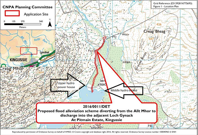
The River Gynack, whose waters flow down through Kingussie from the Monadhliath, floods regularly. This has, over the years, caused serious damage to houses by the river, damaged bridges, flooded the High School and closed the West Highland Line. As a consequence of a serious flood in August 2014 (£100k reported damage to the High School), it was among a number of rivers where the need for flood alleviation works was identified. In 2016 the Pitmain Estate submitted a Planning Application to the Cairngorms National Park Authority to create an overflow channel from the Allt Mhor, the main tributary of the River Gynack, into Loch Gynack. This was not a new idea, there had been an overflow channel here previously (like earlier hydro schemes on the River Gynack) but this had ceased to function c1950. The new overflow was approved in June 2016 (see here for Committee papers).
A year later, in June 2017, Highland Council announced that it had agreed to jointly fund, on a 50:50 basis with the Pitmain Estate, the construction of the overflow channel (see here). The Badenoch and Strathspey Herald reported in 2016 that the cost of the overflow was estimated to be £250k but later a figure of £275k was mentioned. The minimum cost to Highland Council is likely to have been £135k.
Unlike Highland Council, Pitmain Estate stood to gain directly from the construction of the channel as it would feed more water into Loch Gynack and thus into the middle Gynack hydro scheme (estimated annual benefit £10,400).
Work commenced on the scheme in the summer of 2017:

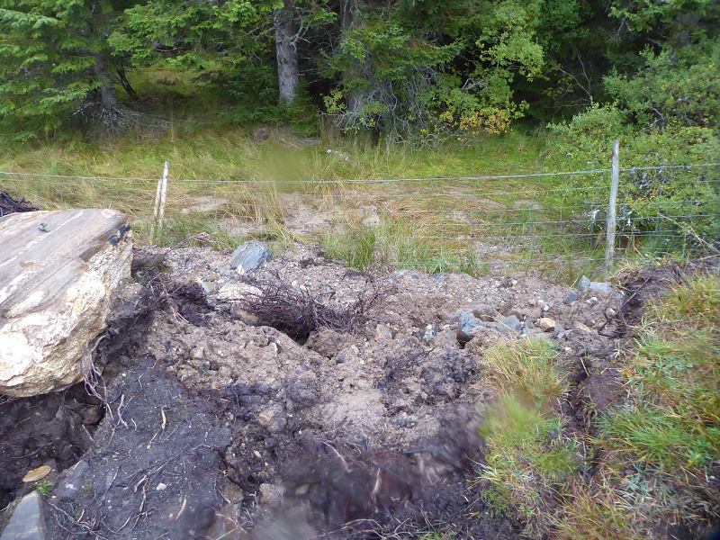
My main concern at the time of my first visit in October 2017 was the source of the material which was being used to construct the banks of the overflow. It appeared that this may have come from further up the hill:

There was no development identified on the planning portal for the area pictured above and it falls outside any planning application boundary. In addition there was nothing in the planning documents that I can find (see here) to indicate that borrow pits would be required Indeed the planning consent required the applicant to provide details of details of “the process for excavation (including machine access and working corridor) and the sorting and storage of materials for re-use”. This suggests that the CNPA expected the developer and contractors to source materials for the banks from the site. If the area up the hill was used therefore to source material to construct the banks to the overflow that was probably unlawful. So, why was no action taken to stop this?
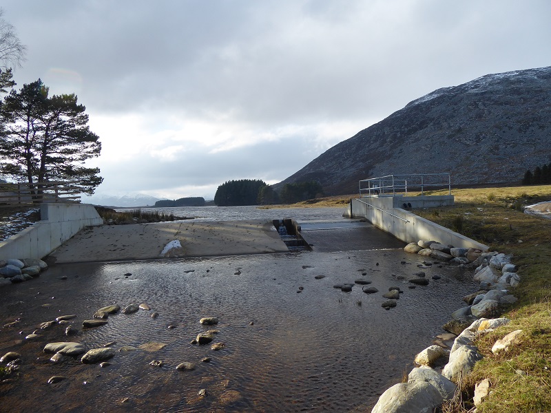
Six months later, in April 2018, Highland Council announced the work was complete (see here). Words which should have come to haunt them. Accompanying that news release are a number of photos which are worth viewing because of what has happened subsequently. The photos were highly selective, focussing on the concrete intake and surrounds rather than the channel itself.
One wonders if Highland Council sent anyone to check the channel in April 2018 before announcing it was complete. Anyone with a modicum of knowledge should have been able to tell then that the banks were unfit for purpose and that might have serious consequences.
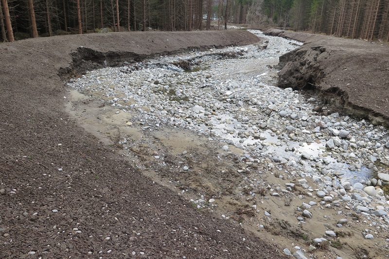
Six months later, when I next visited, the possible consequences were even more obvious. What engineer thought that these earth banks could withstand a river in spate? Why was water allowed to run through the channel before they had had any chance to vegetate? Even if that had been allowed to happen, earth banks such as this would have been highly vulnerable to high water flows, but without vegetation and without any protective matting, the consequences of allowing water to run through the channel should have been obvious. So why the CNPA allow this to happen?
The planning consent granted by the CNPA required Pitmain Estate to produce a revised Construction Environment Method Statement (CEMP) which included “details of measures to stabilise vegetation along the channel banks to ensure this is not washed away in the event of flooding”. Unfortunately, the CNPA, like other planning authorities, still does not publish any information required under planning consents on the planning portal. This makes it impossible to tell whether the information was ever provided without submitting an FOI request and, if provided, whether the information was fit for purpose.
What is clear, however, is that somewhere along the line there has been a failure in planning. Had the channel not been constructed through a forest plantation and had it not been for the tree roots which permeated the based over which the raised bank had been constructed, its likely that whole sections of bank might have been swept away.

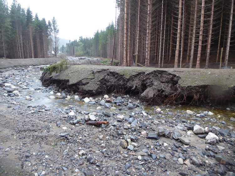
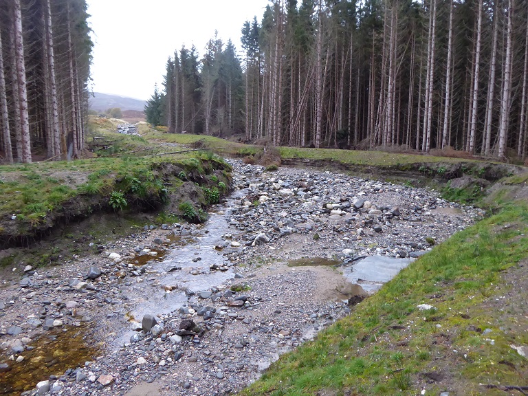
By October 2018 the banks were in places being severely undercut. It appears that in designing the overflow little consideration had been given to the impact of the water on the banks. In the Supporting Information to the planning application consideration had been given to the mobile nature of the natural rivers ABOVE the channel but NOT to the channel itself: As a result the developer, while rightly highlighting that the area above the intake would infill and require regular maintenance (I cannot recall this ever being considered in any hydro application), completely failed to consider what would happen in the channel itself. As a consequences, in just six months in places the water had almost cut through the bank entirely. Had it done so the overflow could have changed course and flooded Pitmain Lodge which lies on the other side of the plantation below this bank! Poetic justice?
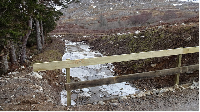
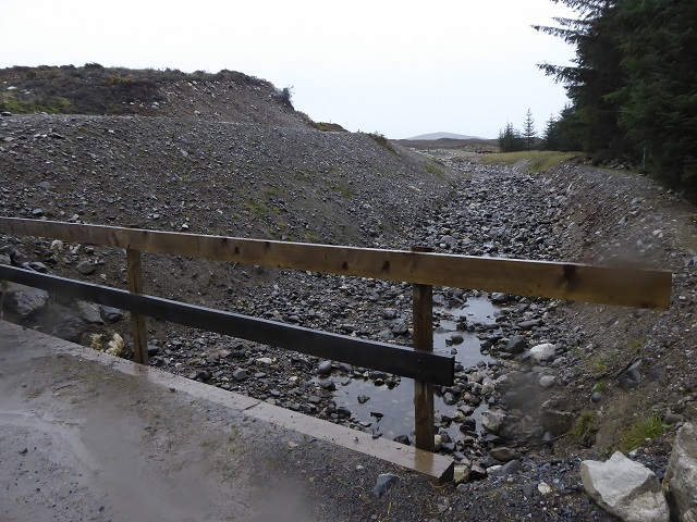
The view of the restoration downstream from the bridge looked not bad in April 2018 though if you look carefully on the right a section of bank behind the fence has already been subject to significant erosion.
Six months later and the water flowing down the overflow had almost cut right through the bank ABOVE the bridge.

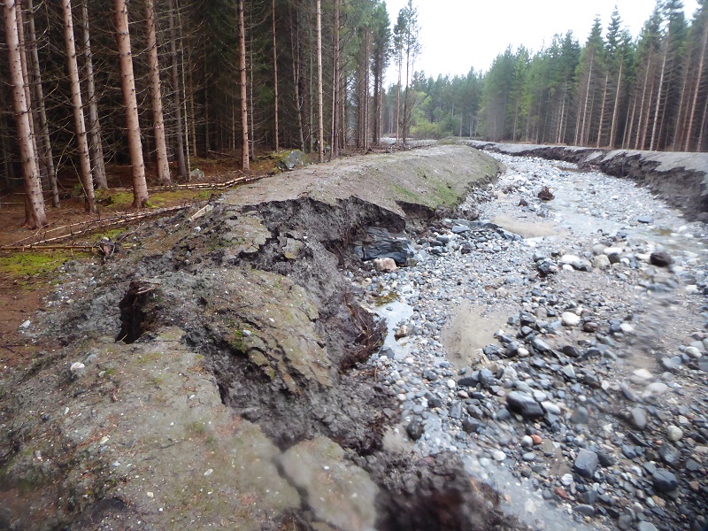
By October 2018 there was also one section of bank which was eroding from the OUTSIDE. This appears mainly to have been a consequence of poor design, the outside slope of the bank being too steep to retain vegetation easily, and poor restoration, with most of this steep slope having been left bare.
In one place, however, it appeared this section of bank had been breached by flood water adding further to the erosion.
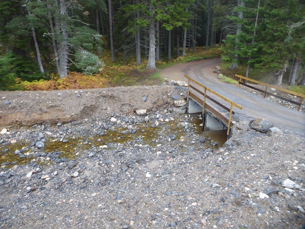
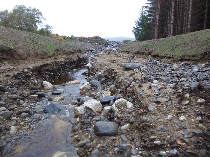 Even more striking was how the channel had cut down below through the original base, doing what rivers that have changed course do, washing away loose material. A good place to study how river channels develop – an ideal geography project for the pupils at Kingussie High School – but in planning terms a disaster. The CEMP required to developer “to provide details of the substrate of the channel when flat”. Whatever these plans were, they have not prevented large amounts of material being flushed into the freshwater system. What is the point of the CNPA and the Scottish Environment Protection Agency requiring developers to take measures during the construction phase to prevent silt being washed into the freshwater river systems (to protect otters, salmon etc) if post construction this happens?

I had intended to blog about what I found at the Kingussie overflow a year ago but left it too long and then decided I needed to visit again in case the position had changed. When I did visit in October, I found the intake had been blocked off. This had limited the amount of further damage that had been caused but made the ugly concrete structures effectively redundant.
The intention, as spelled out in the planning documents, was that the overflow should function as a natural river and water should flow down it at all times:

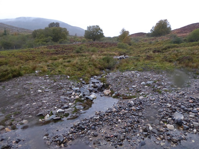
That now only happens if the Allt Mhor and River Gynack are very high although there is some flow below the bridge from feeder burns.
A broader area was deliberately excavated lower down to create a new wetland area. Instead boulders and silt have been washed down from above effectively creating a flood plain – nothing wrong with that but NOT what was intended.
While plants have re-colonised some of the bare banks along the lower half of the overflow, this is not sufficient to prevent them eroding further.

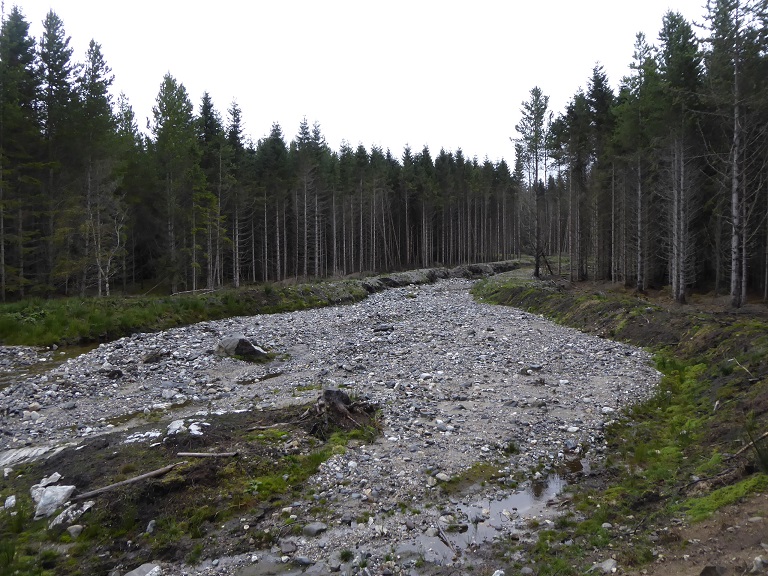
Higher up there are extensive sections of bank with rip rap bouldering. While most of this is still intact, unlike the bouldering used in the Glen Falloch hydro schemes (see here), there are several places where you can see boulders have been plucked out from the banks. Had the overflow not been blocked off, the damage might have become as extensive as that in Glen Falloch.
There are still large areas where there has been no restoration to the banks and they are very vulnerable to erosion. The only reason the bank on the left has not eroded is because the water flow has been directed along the other side of the river – where the bank is eroding seriously.
What needs to happen?
The evidence presented in this post suggests that the response I received from the CNPA’s Head of Planning, stating that the problems with the Gynack overflow are partly the result of planning requirements not being met and partly the result of more fundamental design flaws, is essentially correct. Would that the Loch Lomond and Trossachs National Park Authority be so open about the hydro planning disasters in Glen Falloch.
The big picture here is that despite all the guidance on flood prevention, river catchment plans etc in both our National Parks developments being given the go ahead without proper consideration of the flooding implications: not just hydro schemes and this overflow but other developments such as the proposed new beginners ski area at Cairn Gorm (see here) and a number of developments along the shores of Loch Lomond from Cameron House to Flamingo Land (now temporarily withdrawn). Instead of being in the lead on flood management and setting examples of good practice the rest of the country could follow – which is exactly what our National Parks should be doing – the CNPA appear no better than any other planning authority.
I hope the CNPA Board, which appears more open to self-reflection than the LLTNPA will now take a look at what has gone wrong with the Gynack overflow in conjunction with Highland Region Councillors and the Scottish Environment Protection Agency. Among the questions they might usefully consider are:
- What were the main design flaws in the overflow (starting with the earth banks)?
- Following from this, how should these design flaws have been addressed by the planning process?
- Was the information required under the Construction Environmental Management Plan and then provided by the applicant sufficent to ensure effective restoration of the development?
- To what extent were planning conditions enforced during the construction process, how could that have been improved and why was scheme declared complete when so much restoration work remained to be done?
- How could non-planning staff in the CNPA have helped identify design flaws and restoration issues? (There must have been plenty of staff in the CNPA who could have told the planners this was a disaster waiting to happen).
- What other sources of expertise might the CNPA have needed to call upon to ensure the scheme was fit for purpose?
- And, perhaps most important of all, what was the role of the private sector in this failure (including the agents for the Pitmain Estate, the design engineers, the contractors and the ecological and landscape clerks of works who were supposed to supervise the whole process)?
On a broader front, on current trends, serious flood events appear likely to increase in Scotland as a result of global warming. Currently, the planning systems looks at risk from the perspective of 1:200 year flood events. The Gynack overflow, while intended to reduce flood risks to Kingussie, was never designed to remove the risk of 1:200 year events – the CNPA Committee Report makes it clear that structures in the village would continue to be damaged by the most severe events. Set aside the fact the scheme has now for almost a year provided very little protection at all because the overflow is not fit for purpose, the number of serious flood events are likely to continue. Since 1990 there have been four serious flood events on the Gynack. How many can we expect over the next 30 years, 6, 8, 10 or more?
The evidence of what is happening in Scotland indicates that the Scottish Government needs to re-think its whole approach to flood prevention in the light of climate change. On the planning side, that should include the development of detailed guidance, based on an inquiry into developments that have failed (such as the Kingussie overflow and Falloch hydro schemes) on where such developments should be located (if at all) and how they should be designed in future.
At the same time, however, the Scottish Government needs to create a new framework for land-use in our upland areas so that water drains from the hills less quickly. Its what’s called natural flood management and mean re-thinking grouse moors and stalking estates, both of which as practised at present make significant contributions to flooding.

Muirburn, in particular, promotes water run off and in flood prevention terms its a disastrous practice. Yet here we are in a National Park, allowing the Pitmain Estate to burn the moor, increasing the flood risk to Kingussie, while at the same time the public sector, in the form of Highland Council, has paid for half the cost of a flood diversion scheme. The fact its no longer functioning is simply salt in the wound! People living in Kingussie should have every right to be angry.

Very interesting, Nick. You put the spotlight on an issue which is at last beginning to make waves, so to speak! There are many hydro and related schemes out there which appear not to have been designed with due regard for flood risk, Glen Falloch being one of the most obvious. Those developments which are still at the pre-construction stage, e.g. Glen Etive, need a serious reappraisal to make sure whatever structures are built are actually fit for purpose. The prospect of repeated damage and repair cycles, with all the heavy machinery and track bulldozing that would entail, does not bear thinking about, not least because of the impact on the long-term sustainability of such schemes.
Thankyou for what seems a comprehensive report.