This post takes a further look at the environmental implications of Highland and Island’s Enteprise current planning application to create a beginner’s ski area at Cairn Gorm and a new application to vary the conditions Highland Council attached to the temporary Adventure Play area in Coire Cas.
Development, erosion and flood risks at Cairn Gorm – proof of the problem
It was only after my post on The future of snowsports and the environment at Cairn Gorm that I realised that the Planning Committee of the Cairngorms National Park Authority had considered an application to replace the Utsi footbridge over the Allt Mhor at their August meeting (see here for papers).
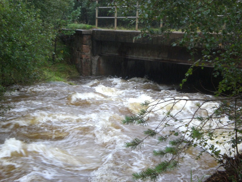
The Allt Mhor drains Coire Cas and the northern corries and is crossed by the ski road which leads up from Glen More to Coire na Ciste and Coire Cas. The bridge, located near the sugar bowl car park, was named after the Swede, Mikel Utsi, who re-introduced the first reindeer back to the Cairngorms in 1952. The reason for the application is that “the integrity of the existing bridge [which dates from 1979] is being undermined by the watercourse”.
The documentation provided by Forest and Land Scotland to support the application is extremely thorough – in complete contrast to what HIE has submitted for the proposed beginner’s ski area up the hill – as is the Cairngorms National Park Authority’s Planning assessment. It confirms there are significant flood risks on the Allt Mhor and provides a valuable insight into the factors that will need to be considered by the CNPA when deciding the beginner’s ski area planning application.
First, the new bridge will have a span of 28.2m compared with the existing bridge which is 21.5m wide and will be 3.3m above the deepest part of the river compared to 1.5m now:
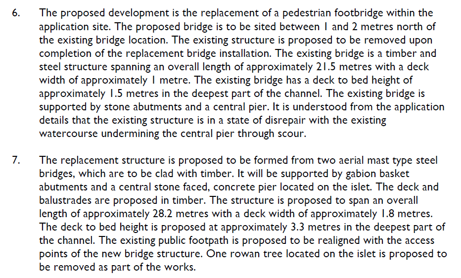
In a nutshell that tells you that the new bridge needs to be longer and higher to avoid it being washed away by extreme flood events. Following this logic, the ski road bridge over the Allt Mhor would appear to be at serious risk of being blocked, flooded or swept away because its nothing like 28.2m wide or 3.3m high:
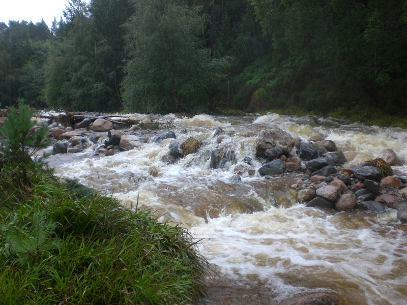
The photo above was taken by Alan Brattey, who intentionally went to look at the Allt Mhor road bridge after a morning of heavy rain on 31srt August. Such rainfall is a fairly common occurrence. The photo shows how little room there is for flood water to pass under the bridge.
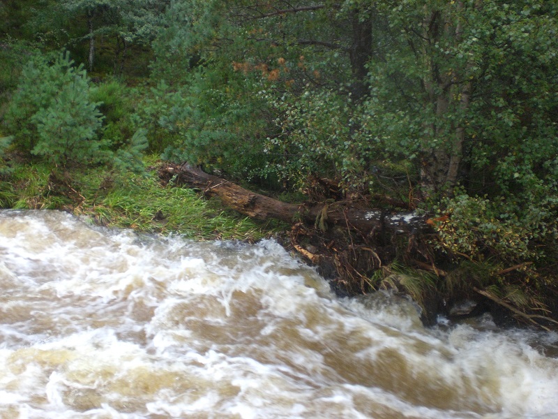
The level of the river on 31st August was significantly below those that occurred in the recent floods that have been covered on parkwatch. Add any more water to that by increasing the rate which water drains off the hill – which appears likely to happen if HIE’s plans to smooth large areas of Cairn Gorm for ski-ing go ahead – and you will have serious problems. This is not just about the risk to the bridge, or indeed the Glen More campsite, its about what happens downstream of that – the impact higher water levels would have on housing, farms and the increased erosive power of River Spey. The design of the replacement Utsi bridge should serve as a warning, a wake-up call.
Thankfully, there are signs in the Utsi bridge planning document that the Cairngorms National Park Authority is not just alive to the issues, it is considering them most carefully. I was very interested to see that as part of the planning assessment they had requested “revised waterway calculations” to calculate the flood risk and ascertain whether the design of the bridge was sufficient to avoid it being swept away:
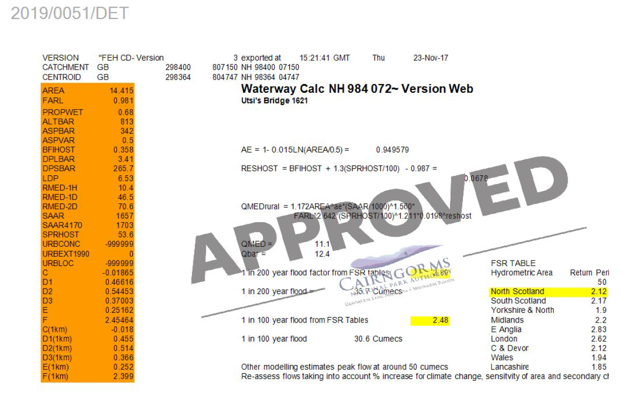
While gobbledegook to me – and probably to most readers – the point is that there are now means of calculating the amount of water which runs off from catchments into river systems in a given period of time. That means that any increased run-off from the creation of a beginners ski area – and more importantly from creating new smooth pistes across the hill as recommended in the SE Group – can be calculated, as can its impact on flooding.
The CNPA identified flooding and flood risk as one the four main factors which needed to be considered as part of the Application. It concluded:
39. The proposed replacement structure is not considered to introduce any additional flooding impact from the existing impact previously established on site. Whilst there is an existing risk of flooding at the site itself, the vulnerability of the proposed use is classed as low and the proposal reduces the flood risk through the use of more flood resilient materials and design. The proposed change in dimensions from the replacement structure to the original is not considered to increase upstream or downstream flood risk. On this basis, the proposal is considered to comply with the requirements of Policy 10: Resources of the Cairngorms National Park Local Development Plan 2015. [“seeks to ensure that all developments do not increase flood risk nor adversely impact on the water quality of the area”]
Apply that thinking to the proposed beginner’s ski area and one would have thought the CNPA will have every reason to reject the Application. One assumes that Planning Officers have now asked HIE/CSML to provide a water drainage calculation for the proposed beginners’ ski area as they did for the Utsi bridge. It will be interesting to see what is shows.
The position of the Scottish Environment Protection Agency
In the words of the CNPA in their Committee Report on the Utsi bridge:
Scottish Environment Protection Agency (SEPA) initially raised an objection to the application and requested the submission of additional information in support of the application. Following this submission, SEPA has removed their objection on flood risk grounds noting that the new bridge would be considerably elevated above the 1 in 200 year floor level and it would be unlikely that this structure would be at medium to high risk of flooring or cause an obstruction to flow.
It may seem strange therefore that last week, while lodging provisional objections to the Beginner’s ski area planning application on the grounds that there was insufficient information to assess its likely impact on bog (Ground Water Dependent Terrestrial Ecoystems in the jargon) or pollution (see here), SEPA did NOT object on grounds of increased flood risk.
3.1 We have no objection to the proposed development on flood risk grounds. Notwithstanding this we would expect Cairngorms National Park to consult The Highland Council to undertake their responsibilities as the Flood Risk Management Authority. Please see the attached appendix with our technical assessment in this regard.
The explanation for this is that SEPA believes the site itself is unlikely to be put at increased risk of flooding if its smoothed out and drains are added. That appears true – its a sloping site, a necessary requisite for a beginner’s ski area! HOWEVER, they then clarify in the technical appendix that this development could well cause flooding elsewhere through higher water run-off but its not their responsibility to address this:
The supporting statement shows two new drainage pipes which will drain into the watercourse, and we note the concerns from a third party regarding an increase in flood risk and discharge of water from the site into the small watercourse. We would assume that all surface water from the site would currently drain into the small watercourse, but the new pipes may have the potential to increase the rate at which it discharges by increasing the efficiency of the drainage. Scottish Planning Policy states that surface water drainage measures should have a neutral or better effect on the risk of flooding both on and off the site. However we consider that the water quantity aspects of surface water drainage is the remit for the local authority to consider and are better placed to provide more detailed advice on this matter.
My understanding is that responsibility for assessing increased water run off may lie with the CNPA, which is lead Flood Risk Management Authority for the area, rather than that of Highland Council but whether or not I am right about this, the point is that the impact the proposed beginner’s ski area on flooding in the Allt Mhor and wider afield needs to be properly assessed.
HIE/Cairngorm Mountain Scotland Ltd’s latest planning application at Cairn Gorm
Just 10 weeks after having been granted planning permission by Highland Council for a temporary tube slide, zip line and play area by the side of the Coire Cas carpark (see here), CMSL have applied (see here) to vary the first of the conditions required in the Decision Notice:
“This Section 42 application does not proposed any change to the long-stop date of Planning Permission 19/01765/FUL (1 November 2021). It does proposes to not comply with the terms of Condition 1 of that permission. Specifically, this application seeks to remove from Condition 1 the provisions which require the removal of the equipment from the site for the five-month
period of November-March (inclusive) in each and every year for the duration of the temporary permission.”
What this means is that HIE/CMSL no longer wish to remove the adventure equipment over the winter but would prefer to leave it exposed to the Cairn Gorm weather and in everyone’s sight.
The application was to Highland Council and on Monday the CNPA decided NOT to call it in – but to leave it to Highland Council to decide. I suspect they had little choice but to do this, having allowed Highland Council to decide the original application. The new application, however, is yet another example of HIE ignoring the CNPA’s request for a masterplan at Cairn Gorm. The CNPA would be wise to advise HIE that until a masterplan is produced they will, in future, call in ALL planning applications at Cairn Gorm, however minor looking.
I hope that the objection I have lodged today speaks for itself and that other people will do so:
“I object to this proposal. The applicant has provided NO justification for removing Condition 1 from the Planning Consent granted by Highland Council and the reasons for imposing that condition therefore still stand. They were rightly imposed to reduce the impact of the “adventure” equipment on the landscape and the amenity of those visiting Cairn Gorm with the basic principle being that in periods when they could not be used they should be removed. In that respect, Highland Council should be asking the applicant to provide data on how many days its been possible to use the equipment to date since its been installed – the high rainfall in the last month suggests not a lot. There is a high risk that if Highland Council removes this condition, CMSL could at some stage abandon the equipment and would be under no obligation to remove it until the planning permission lapsed. Its worth also noting that while not calling in this application – it is relatively minor – the Cairngorms National Park Authority has for months been asking HIE for a masterplan for Cairn Gorm before any further planning applications are submitted and that if Highland Council consents this request, in the absence of a masterplan which shows how this allegedly temporary equipment fits into their long-term plan for Cairn Gorm, it will effectively encourage HIE to continue to ignore the pressing need for a masterplan.”
Separately, I will ask HIE for data on how much usage there has been of the adventure play area and how much income they have raised from it. My suspicion is that its yet another ill-thought out loss maker which is why this application has been submitted: HIE don’t want to pay for the costs of removing and storing the equipment over the winter.
Leaving the equipment in place during the Cairn Gorm winter can also only make it deteriorate more quickly. It provides another indication that this initiative has failed and the equipment is likely to be abandoned well before the five year period is up. There are lessons here for all the other developments HIE are considering on the mountain. Tourist facilities like adventure play areas and zip wires are inappropriate and should, where this is demand for them, be located low down in sheltered areas.
What needs to happen
Both the Utsi bridge and Adventure play area application show is that there is a need for a masterplan for ALL proposed developments at Cairn Gorm.
A masterplan needs to include a comprehensive assessment of the impact of HIE’s development proposals as a whole on flood risks. Cairn Gorm could, I believe, sustain some new development, but each new development will have an impact on flood risk and erosion. Consideration therefore needs to give to total impacts of what is proposed and how this could be offset, whether through removal of existing development or mitigation measures (such as reforesting the hill). Overall limites then need to be set on the extent of any new development. The CNPA cannot do that while HIE continues to submit development proposals piecemeal. The were quite right to ask for a masterplan.
Both the CNPA and Highland Council also need to put a stop to HIE’s continuous attempts to undermine previous agreements – as represented by the new application to allow the adventure play area equipment to remain in place over the winter.
The contrast between Forest and Land Scotland’s responsible approach to the Utsi bridge application and HIE’s approach to planning applications at Cairn Gorm is striking. This offers further proof that the best way to start to address the planning and development failures at Cairn Gorm would be for Fergus Ewing, the Minister responsible for both agencies, to transfer the Cairn Gorm estate back to Forest and Land Scotland from HIE. When will he act?

Concerning who is the responsible body for the increased flood risk from upgraded drainage in Coire Cas, it’s interesting to see SEPA’s response in trying to pass on the flood risk to the Highland Council Flood Risk Team. This usually happens in residential/industrial developments when there is a need to hold back storm water (from roofs and roads) using for example a SUDS scheme. It is Highland Council Flood Risk Team’s responsibility as a statutory consultee to CNPA on such matters to ensure that such flood prevention schemes are designed and built correctly. However, this is the first time that I have seen SEPA pass the buck to this team for what is essentially a ‘rural’ drainage scheme. If we accept what SEPA has said on this, then CNPA need to ask the Highland Council Flood Risk Team for formal comments on this application.
CMSL’s highlighted answer in 1.5 of their response to SEPA (document on the CNPA planning website) is absolute nonsense. (The words are reproduced below)
1 5 The supporting statement shows two new drainage pipes which will drain into the watercourse, and we note the concerns from a third party regarding an increase in flood risk an discharge of water from the site into the small watercourse. We would assume that all surface water from the site would currently drain into the small watercourse, but the new pipes may have the potential to increase the rate at which it discharges by increasing the efficiency of the drainage. Scottish Planning Policy states that surface water drainage measures should have a neutral or better effect on the risk of flooding both on and off the site. However we consider that the water quantity aspects of the surface water drainage is the remit of the local authority to consider and are better placed to provide more detailed advice on this matter.
(CMSL’s response)
Noted- Although the drainage pipes proposed will be new they are to improve the existing open ditch created in 1960. We do not believe that these works will alter the natural water course of the Allt Choire Chais as the existing drainage channel already feeds directly into the Allt Chais and we are not increasing the amount of water flowing. Snow capture and snow melt widely create fluctuation in the water volumes from year to year without any adverse effects in this area.
The very fact that they wish to install extra drainage pipes is to drain away the surrounding land. This water will consequently drain away faster contributing to higher water levels downstream – unless it is controlled by a SUDS type storage scheme or some other means. Additionally there is no mention that the fact that CMSL is making snow in this area which melts regularly over the winter DOES increase the amount of water flowing. Highland Council Flood Risk Team’s response, (as should have been SEPA’s response) that a professionally produced flood risk assessment is required before they can comment further – i.e. similar to the calculations produced in support of the Usti bridge.
Lastly, as all this new information on the planning application webpage is significant, CNPA should extend the consultation period to permit the public to add their comments on these developments.
” we are not increasing the amount of water flowing”. CMSL is going to produce a greater volime of snow than would occur naturally which when it melts WILL therefore increase the flow of water. What is not mentioned is if the new drainage pipe is perforated or not? A perforated pipe allows water from the surrounding ground to enter the pipe, whereas a solid pipe doesn’t, which will therefore lead to a watercourse forming underneath it with the potential for it to eventually collapse.
Yes, Graham, my mistake on the water volume – I forgot that the water for the Snow Factory and cannons is locally sourced and this is recycled, however the comments on the increased flow rate adding to flood risk downstream are full valid.