Today the South Area Planning Committee of Highland Council is taking a (road-side) look at the sites of all seven proposed Glen Etive Hydro Schemes, and a further hydro scheme in Glen Coe. Then, at a special meeting on Wednesday at Council HQ in Inverness they will take a decision on the applications (see here for links to details of visit and Committee Reports). Planning Officers are recommending all 8 schemes should be approved despite the very high levels of public concern and the likelihood they will desecrate one of the wildest, most beautiful and most renowned glens in Scotland. This post explains why Councillors should reject their officers’ recommendations.
Glen Etive is the wrong place for run of river hydro schemes
“SPP (Scottish Planning Policy) sets out a presumption in favour of development that contributes to sustainable development and aims to direct the right development to the right place.”
The Committee Report makes no attempt to justify Glen Etive as being the right place for hydro schemes. Instead, it minimises the likely impacts of the proposed developments and mis-interprets the intention of the designations designed to protect areas like Glen Etive from inappropriate development .
The Committee Reports quote without qualification or criticism the conclusion of the Developer’s Landscape Visual Impact Assessment:
“that the combined construction activity of the seven developments would be limited to a very small part of the NSA in the context of the entire 1000km2 and any effects would be localised”
The Report appears to see Glen Etive as less important than other parts of the NSA:
“Glen Etive is not of the same awe-inspiring grandeur (as Glen Coe), but nevertheless is a deep cleft through towering peaks, notably the portal peaks of the Buachailles and the great slabs of Ben Starav”.
At the same time it minimises the importance of the recreational and Wild Land experience. This is in some ways much stronger than in Glen Coe due to the absence of a major road and constant roar of traffic:
“For the three schemes within the WLA, taking into account their location near the edge of the Wild Land Area,…………….”
It is also mistakenly argues that cumulative impact only applies to developments that you can see at the same time:
“As discussed in the cumulative landscape impact assessment above, there are few locations that more than one or two schemes are viewed together.”
This discounts the impacts on the journey down the glen or along the mountain tops.
There is also no discussion that the location of all three schemes on the east side of the River Etive, the Allt Chaorainn, the All Ceitlein and the Allt Mheuran, are not just in the wild land area, they provide the main access routes into these hills. You could not choose locations at the “edge” of the Wild Land Area where the impact of developments on the recreational experience would be greater. Yet the Report sees these of little importance, for example in relation to water flow (which affects both walkers and paddlers):
“the restrictions on water abstraction put in place by the CAR licence will allow these features to remain, just less frequently”.
Councillors would do well to consider the famous Eagle Falls at the head of Loch Lomond which are now a shadow of their former glory due to the Ben Glas hydro scheme.
So, its worth saying that if there was a National Planning policy for hydro as there is for windfarms, we would have NO hydro schemes in Glen Etive. The reason the schemes are being proposed in this location is because Dalness Estates has done a deal with Dickins Hydro which will enable both to make a lot of money, paid for by the public in inflated fuel bills, should the schemes are approved. I have been informed that other, more responsible developers, avoided Glen Etive because they believed it was the wrong place. That says everything you need to know about how ineffective our planning system is in directing development to the “right place”.
The landscape information provided to Councillors and the site visit
Alongside the Committee Reports, Councillors have been provided with Landcape and Visual Impact Assessment Viewpoint Information (see link to papers above). The photomontages in the report all date from December 2017 and about half have now been superseded. While there is a section within each Committee report explaining the changes, there are no photomontages of what has now been agreed between Planning Officers and the Developer. Committee Members therefore have not been provided with appropriate photographs to inform their decision.
Unfortunately, this will not be rectified by the site visit, where ALL the viewpoints chosen for the visit are along the road:
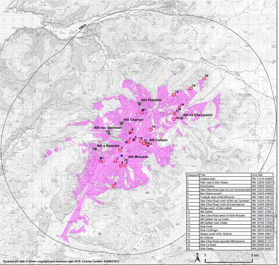
Viewpoints
1. Meeting point – Layby near Etive Mor waterfall (first bridge on Glen Etive road)
2. ‘Skyfall’ layby
3. Access to Allt Chaorainn scheme
4. View looking back to Allt Chaorainn scheme
5. Car park at Inbhirfhaolain
6. Layby on approach to Invercharnan
7. Invercharnan
8. Access to Allt Ceitlein and Allt Mheuran schemes
9. Layby near Loch Druimachoish
10. Car park at end of public road
11. Jetty
Councillors therefore are not being provided with information with which to assess the potential landscape impact of the intakes, pipelines and access tracks. They will be able to see that location of the powerhouses from close up but that is about all. That means they will not be able to judge for themselves claims, such as this, from the Planning Report:
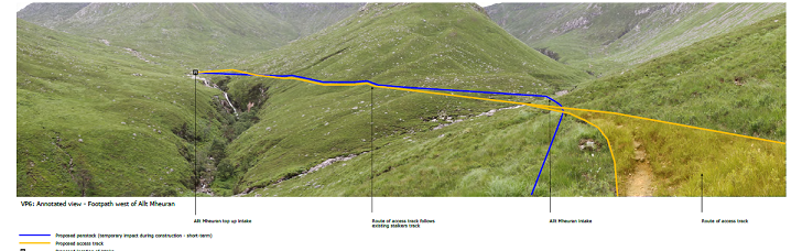
“Improvement works are proposed to the existing vehicular track serving the Allt Mheuran”
That’s not true, most of the road will be completely new (as is implied by other information in the Report).
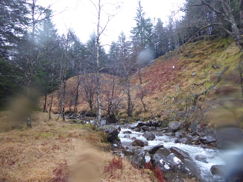
Failure to allow Councillors to see what is at stake is a particularly major failing when arguably the most significant part of the landscape impact of these schemes is alongside the burns and the three on the east side of the glen are renowned, Scotland-wide, for their beauty:
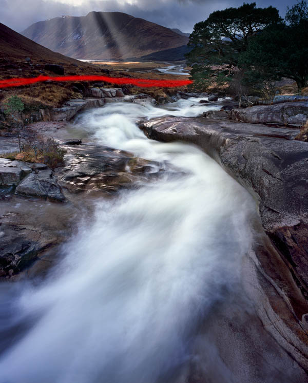
It is not however in the Developer’s interests to show its plans in too much detail.
What Officers have required is a new assessment showing the Zones of Theoretical Visibility from a 10km instead of a 5km radius (map above). This is dated January 2019 and corrects some of the omissions (missing intakes) from the original ZTV Assessment. It still however does not cover the access tracks or pipeline routes.
Given the steep sided nature of the glacial trough that is Glen Etive, its not surprising that extending the assessment to a 10km radius makes very little difference or that SNH concluded “that the proposals will have a localised effect on the sense of wildness”. ZTVs were designed for windfarms, not hydro schemes, so assessing the impact from afar misses the point. The landscape and wild land impacts of these proposed schemes are ALL local. That shouldn’t make them any more acceptable.
The Material Objections to the schemes
The Committee Reports list the material objections to the schemes – up to 53 in the case of the Allt Mheuran – but does not mention who made the objections or their expertise. Are Councillors not entitled to know that Mountaineering Scotland, John Muir Trust, the Scottish Canoe Association or John Mackay, possibly Scotland’s foremost landscape expert and former employee of SNH, all lodged objections?
The report addresses some, but not all, of the objections but does not consider in detail the evidence referred to by objectors:
Material considerations raised are summarised as follows:
1. Affect the character and ecosystem of the river and its flow
2. Impacts from construction traffic
3. Environmental damage from construction works
4. Detrimental impact on recreational users during construction and post
construction
5. Dramatic and long term effect on character of the area
6. Cumulative impact – all seven application should be considered together
7. Impact on tourism
8. Impact on Wild Land
9. Impact on National Scenic Area
10. Impact on Nationally significant Glen
11. Disagreement with SNH’s assessment/consultation response
12. Noise and disturbance will affect character of the Glen
13. Impact on amenity of visitors
14. Glen Etive road not suitable for construction traffic
15. Impact on ecology and protected species
16. Energy benefits do not outweigh the environmental impacts
17. Limited employment benefits
18. Important Glen that should be left unspoiled for future generations
19. Support for development of hydro electric power
20. Contrary to national and local planning policy
21. Impact on landscape and heritage assets
22. Impact on peat and soils
23. Impact on public access and transport network
24. Impact on geodiversity
25. Impact on water environment
26. Impact on amenity
27. Impact on health and wellbeing as a result of impact on natural environment
28. Inappropriate design of powerhouses- not ‘Scottish bothies’ as referred to
29. Visual impact of tracks, intakes, powerhouses and deficient restoration –
reference to other schemes in Highland and other parts of Scotland
30. Net contribution to carbon emissions not properly evaluated
31. Power generated is insignificant in UK context
32. Scottish Planning Policy and its administering inadequate for natural heritage
33. Industrialisation of important landscape
34. Deficiencies in the visual impact assessments
35. Lack of detail in the application
36. Scale of development is disproportionate to Glen Etive
37. Landscape impact of dried up rivers/loss of cascades
38. Impact on canoeing/kayaking from reduced river flow – estimated number of
days the river would be available would fall from around 180 per year to 60 per
year
39. Safety of kayakers using river when flow rates are changing more rapidly
40. No agreement has been reached with the Scottish Canoe Association re
mitigation of the impact on canoeist or kayakers
41. Geomorphological impact of schemes – impact on ecology of River Etive
42. Environmental impact from in river works
43. Impact on private water supply
44. No local community to benefit from the scheme
45. Impact from upgraded grid connection
46. No details of ongoing maintenance of tracks
47. Ecological Clerk of Works and Landscape Clerk of Works should be employed
48. Lack of detail on access tracks
49. Lack of detail on construction of intakes
50. Reinstatement if scheme no longer used
51. Concerns over the timing and purpose of the resubmission of two of the
applications.
52. Contrary to SNH Guidance on Constructed Tracks in the Scottish Uplands
guidance
53. Impact on Chequered skipper butterfly and its breeding habitat
This provides excellent evidence of how our Planning system is stacked in favour of developers. The assumption of planners is that developments will go ahead even when there are large numbers of so-called material reasons for them not being agreed. There was an excellent post on this at the end of last month from Planning Democracy (see here) which, though focussed on housing development, could just as well have been about hydro development. It explains just why our Planning system is so discredited.
A misplaced faith in restoration
The Committee Report assumes that the land affected by these hydro schemes can be fully restored, leaving very little long term impact:
“the main individual and cumulative impacts of these developments relate to the construction phase”
This claim is undermined by the wishy washy conditions attached to many aspects of the development. For example:
“No development shall commence on the construction of the intakes hereby approved until the final detailed designs have been submitted, to and approved in writing by, the Planning Authority. Such details shall include measures to visually soften their appearance as far as it practicable.
Measures such as facing the weirs with carefully placed boulders, cobbles and using textured or coloured concrete or other materials should be considered when finalising the design. Thereafter the development shall be undertaken in accordance with the approved details”.
This condition suggests that the Developer should consider doing certain things, “as far as is practicable”, it does not REQUIRE them to happen. Its the same with vegetation and landform restoration, its all “as far as possible”.
If the landscape really could be restored as claimed, why don’t the conditions require that? Instead they require the developer to appoint landscape and ecological clerks of works, who are completely dependent on the them for their pay, to provide reports which get filed without independent checking. This doesn’t work, as every planner within Scotland should know. Yet Planning Authorities still hand responsibility to the developer to police what they do. The consequences, if this planning application is approved, are quite predictable.
The Reports also fail to give any consideration to the fundamental engineering challenges I identified on my visit to Glen Etive before Xmas (see here) and (here). Our statutory agencies are most concerned about the impact of the pipeline on peat but not the solid rock through which the Allt Mheuran and Allt Chaorainn pipelines will need to be excavated. There is still nothing in any of the Planning documentation or the Committee reports to say how this will be done:
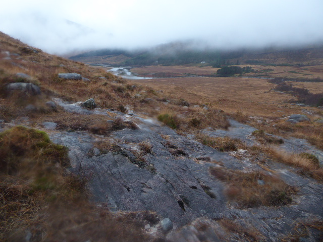
Nor is there anything to say how the pipelines will be constructed along the steep banks in sections of the Inbhir Fhaolain and Allt Charnan schemes:
Instead this is how the Committee Report describes the Allt Charnan:
The existing forest track from the car park gently gains height, curving through the commercial plantation. The first 0.5km of this track is to upgraded to allow construction traffic and further 1km section of new track is to be formed up to the main intake. The penstock will largely follow the route of the construction track, with the exception of the first section from the car park. A 20m corridor of conifer plantation will need to be felled through the wood to facilitate construction. During construction the penstock will be reinstated as work proceeds, i.e. only 100m of penstock trench open at a time and closed again within 7 days. Following construction the new section of construction track will be reinstated to a 1.5m ATV track with green central strip.
Not a hint to Councillors there could be any challenges. I have not seen the other three schemes but I wonder if the Planning Officer has visited and logged the very real engineering challenges? Either the Officer has not checked or lacks the necessary expertise to evaluate these proposals or councillors would appear to be being deliberately mislead. Whatever the case Councillors have a duty to put this right and in my view should not even consider giving any approval to these schemes until the Developer can show how the intend to bury the pipeline in these locations and then restore the ground so it appears as it does at present.
The conclusion of the Committee Report
Planning Officers have responded, to a degree, to public concern about these schemes:
Key changes include a significant reduction in the Allt Mheuran scheme, removal of an intake on the Allt Ceitlein scheme, reduction of tracks and reducing, relocating and part burying powerhouses.
Its been worth people objecting, therefore, although the fundamental question, whether this is an appropriate place for hydro schemes has not been addressed:
9.1 The assessment of this application and the other six associated applications for hydro schemes within the Glen is a careful balance between National and local support for renewable energy and protection of important environmental resources. The greatest impacts from the development, both individually and cumulatively, will be from the construction phases. The schemes have been amended to take account of issues raised, appropriate mitigation has been proposed and conditions recommend to secure the best management of the construction process and provide for successful restoration of the disturbed ground.
The conclusion is telling, its the same for all seven schemes, despite their different landscape setting and landscape impact.
I and a few others opposed all seven Glen Hydro schemes because of their impact on the integrity of the National Scenic Area even though four are partly or largely at present within forest plantations while three are in far more open country and in a Wild Land Area. Its understandable why the John Muir Trust only objected to three schemes, even if in my view we should not be adding to the damage that has been done to NSAs by inappropriate forestry in the past. Yet, officers have made no attempt to differentiate between any of the schemes and have concluded that all equally acceptable. That is incredible and just wrong.
The implication is even more chilling, that they would recommend any development anywhere, so long as there was some “mitigation”. This approach to landscape protection is totally inadequate and undermines our whole landscape protection “system” or the shreds that remain of it.
I hope that Highland Councillors, despite the limited nature of their site visit and the skewed information which has been presented to them, will on Wednesday have the independence of mind to make a decision based on whether Glen Etive is the right place for hydro developments.

Yes, we have a broken and undemocratic planning system in which the Planning Authority officials will make their own decision, no matter what objections and comments are submitted by members of the public, even when these objections and comments are technically material and competent. This is compounded by the rules on Planning Committee site visits which do not permit objectors to participate in the discussion – yes objectors can be present, but are not allowed to speak and usually the planning officials try to keep much of the conversation out of earshot.
Yes, we have all the documents, policies and words on NSAs, SSSIs, Wild Lands, Natura sites, boidiversity challenge, land use strategy, forestry strategy, etc. etc., but these more and more are just looking like window-dressing documents.
You are absolutely correct, Nick. Anywhere and everywhere is suitable for hydro as far as our so-called planners are concerned, and they couldn’t give tuppence for the arguments raised by objectors. Don’t councillors do any research of their own? Are they really going to rely solely on what the planners feed them?
GLVIA, ever heard of that?
Guidelines for Landscape and Visual Impact Assessment from the Landscape Institute “GLVIA3 replaces the second edition GLVIA2. In general terms, the approach and methodologies in the new edition are the same. The main difference is that GLVIA3 places greater emphasis on professional judgement and less emphasis on a formulaic approach.”
Is there anything left to do, anyone we can email or call to continue to object?
I have emailed all the Councillors on the Highland South Planning Committee with links to my post, but if you live within Highland in one of wards represented on the Committee, it would really help if you could contact ALL the councillors for that ward making your views known. You can ask that Councillors not on the Planning Committee raise questions/issues for their colleagues on the Planning Committee to ask. Any media coverage also helps – social media at this late stage.
The councillors responsible for these schemes should be shown how badly most of the other hydro schemes in Scotland have been reinstated. Requirements must be mandatory not advisory and scheme implementers should not be allowed to generate income until all reinstatement actions are complete.
Often the Planners will have a different view of the Planning Board. The Planning board is more often than not made up of senior staff/councillors who do not have a planning degree, but rather have a quick bit of Planning training so they know the process. One early criticism is that an augmented 3D proposal should have been requested with this type of application.
I am torn buy this development. Having paddled some of the etive and also climbed on the Etive slabs and the Buachaille it would be horrible to see an industrial mess in one of our special wild(ish) areas.
However I feel that perhaps as humans we need to make hard choices to ensure that we don’t get run away Climate Change and totally screw the environment up. I think the majority of Norwegians have this mentality as they have taken hard decisions, however they have more money and do this generally better than we do in the UK.
I bet you this development could be built with little visual impact however it wouldn’t be cost effective for a private company, with shareholders, which is probably why Alexander McGrath above has seen inadequate reinstatement.
I think we need to do lots of micro-hydro schemes close to towns and villages, even if the return on investment isn’t for a long time. This is perhaps just in the wrong place because of its scenic quality. Perhaps we need to do these schemes as a very long term financial gain 20+ years. Obviously this would result in public money being used, which could mean higher taxes. It not an easy decision.
I was annoyed with myself for not being aware of this application last summer, but nevertheless it beggars belief that Highland Council would actually grant planning permission in this most beautiful and cherished of locations. Those responsible, the landowner, the developer and the planners should be ashamed of themselves. This is an area whose value lies in its immense natural capital, so to risk that for an insignificant amount of power generation seems perverse in the extreme. For example one of the delights of approaching Ben Starav is marvelling at the rapid cascade of the Allt a Mheuran, much photographed and I believe of national significance as a landmark feature in its own right. Planners should understand that the total power output of all hydro schemes across Scotland amounts to that of about one medium sized power station, in other words generally a waste of time at the expense of the environment, where rivers and typically salmonids are seriously affected. In the UK we cannot replicate the serious heads of water that make hydro viable (eg in Switzerland where water can be dropped thousands of feet with relatively little environmental impact). This is an ill advised decision by people who can’t appreciate the value in their surroundings. It’s not quite on a par with placing a barrage on the Awe river in the 1950s (and thus wrecking the finest river on the west coast of Scotland for the enjoyment of all future genetations) but it’s not far off, and I thought we lived in more enlightened times now. Can this decision not be challenged and given scrutiny at the (national) level it merits?
Why has this issue not been raised in the Media and raised in Parliament, it is a National disgrace that for the benefit of a few greedy landlords.
If it is to produce Hydro Power why has their finance been diverted to Tidal & Wave power where backing in many cases has been dropped.
No other Democratic country in the world would allow planning to take place to the detriment of its people, landscape and environment.