On Friday the Cairngorms National Park Planning Committee, which all Board Members sit on, will consider the Balavil Estate’s Planning Application to build 5km of new road into the Monadhliath Wild Land Area (see here for all papers). The December CNPA Planning Committee rightly agreed to defer the application because it had not been advertised properly (see here). The closing date for the consultation was 10th January. Officers then produced a revised Committee Report recommending the application be approved in the space of just six working days in order to get the papers to Committee a week before the meeting. The short turnaround is surprising given the serious issues raised by objectors, who include all the main Non-Governmental Organisations concerned about hill tracks and Wild Land. It maybe accounts for a number of material planning considerations which officers have avoided or glossed over in the Committee Report. This post takes a critical look at the Report following my previous post on why the Planning Application should be rejected (see here).
Positives and negatives about the revised report
On the positive side, the revised Committee Report has rectified some previous policy omissions (both on Wild Land and Hill Roads) and considers the Application against these. It also contains, in Appendix 2 (see here), copies of all the Objections received. This is important as it should enable Committee Members to understand why NGOs and individuals concerned about Wild Land have objected and whether officers have responded appropriately to these concerns.
On the negative side, the Report contains: NO photos, which makes it very hard for anyone to judge how far the claims of the applicant or officers are true; NO maps of other hill roads in the vicinity or the extensive damage by All Terrain Vehicles, which makes it impossible for anyone to assess the cumulative impact of these roads on the Monadhliath Wild Land Area; NO zones of theoretical visibility assessment to show the points from which the new road might be visible; and NO assessment of whether the Application supports the CNPA’s land-use objectives, including large scale landscape conservation.
The Park’s policy presumption against new hill roads
CNPA Board Members have rightly been concerned about the proliferation of hill roads for some time and in a welcome move included a “presumption against new constructed tracks in open moorland” in the 2017-22 National Park Partnership Plan. That raises the question of what exactly “presumption” means in planning terms and how it should be applied. This has now been articulated in the draft Local Development Plan, which by happy coincidence is being issued for consultation on Friday, the same day as the Committee Meeting. The Committee report does refer to this:
The Cairngorms National Park Partnership Plan 2017 (NPPP) includes a policy (1.3e) “applying a presumption against new constructed tracks in open moorland”. This is not planning policy but is a material consideration for the section of track within the National Park in this planning application. The Proposed Cairngorms National Park Local Development for 2020 (Proposed LDP), that will be consulted on from 25 January 2019, includes a new policy statement on Private Roads and Ways, articulating the NPPP policy statement in planning policy and supporting text. The policy and text are relevant material considerations to this application, but given the early stage of this plan, only limited weight can be given it in decisions at this time.
However, it fails to quote what the proposed new policy actually says:
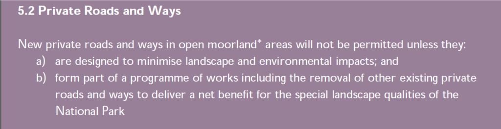
The meaning of this is very clear, new roads should only be permitted where they are of a high standard AND lead to the removal of other roads. This is to be welcomed. It would allow for Wild Land Ltd to continue with their programme of re-aligning some roads in Glen Feshie and Glen Tromie, so that their landscape impact reduces, but makes it much harder for estates to construct tracks into new areas.
There is, however, no programme of works in this sense at Balavil – unless this has been kept secret. Nor are any existing roads going to be removed in compensation. As a result the proposed Balavil Rd fails the new policy test. Now, of course the new policy still needs to be approved and, as officers have said, until that happens it carries less weight. However, the same Board Members who sit on the Planning Committee approved this new policy for consultation only last month. If they discount it on Friday, they will need to be very clear why otherwise they risk undermining it completely.
Instead of quoting the new policy, the Committee Report glosses over the requirement to remove existing roads and interprets it as follows:
The Proposed LDP Policy 5.2 is intended to turn the NPPP policy into an effective planning policy. It does provide for the possibility of new constructed hill tracks where they are clearly required for management, are well-designed, and incorporate the removal of other tracks. In this case, the proposal is to replace a long-standing vehicle route with little formal construction with a constructed track that is intended to have fewer landscape, visual and environmental impacts. The proposal incorporates measures for restoration of land damaged by vehicles around the main track line. The
proposed route follows the long-established estate route across their ground to the river Dulnain. The estate has no other reasonable alternative route within their control. Subject to appropriate conditions ensuring minimisation of impacts, the proposal would be considered to comply with Policy 5.2 of the Proposed LDP if it were applied.
This suggests, In effect, that what the draft policy really means is that if a new road in an area of open moorland removes the scars caused by All Terrain Vehicles, the removal of those scars will count as removal of a road. If that was the intention of the CNPA Board when approving the new policy for consultation, it needs to be re-written. That, however, would open the door to any landowner who wanted to build a new road to first create damage in the area through ATV use. It would make the CNPA’s policy presumption against new roads meaningless.
Routes, tracks and roads
The Committee Report refers to “routes”, “tracks” and “roads” but is not clear about the differences. This is well illustrated by the way the Planning Application is now described:
Upgrade to existing hill access for vehicles, including sections of new track construction, and repair and improvements to existing track, between Allt Ruighe na Riog and River Dulnain at Balavil House Kingussie Highland PH21 1LU
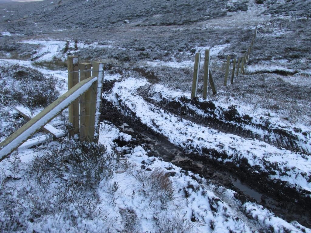
While this corrects the original application, which was described as “Repair and improvements to existing hill road/private way at Balavil House………..”, it is still misleading on two counts. First a new road is proposed, which in planning terms has a specific status and is different to a route or a track. Second, it implies there is already a track along the whole of the route which is in need of repair and that upgrading this will be an improvement.
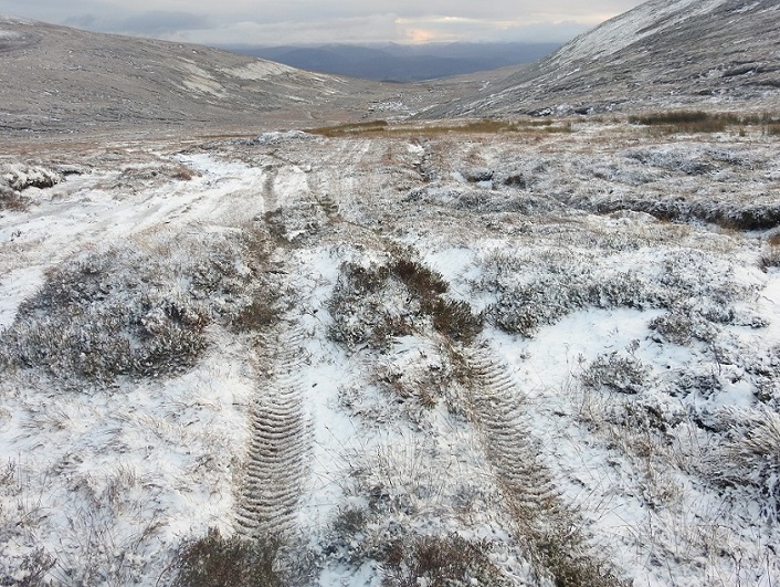
You can have a route without a track. As the Committee Report says, on the Balavil Estate there is now no sign of the old drovers route, which followed the western end of the proposed new road. Nor is there any sign of the old pony route which was used by the Balavil Estate for stalking until about 40 years ago when they brought in argocats. I have heard from a local source that for many years the argocats had very little impact because the estate deliberated controlled their use and vegetation was given time to recover. So, for a long time, there was a route here but no track. Even with far more intensive vehicle use recently, there is still no continuous track in a meaningful sense along the whole of the route:
What’s more, for a significant section of the route where repeated vehicle use has created a track,se, its impact is slight.
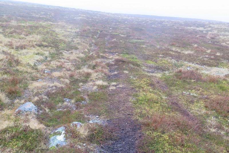
In fact, for the final 2km or so of the 5km route, where it follows drier ground over Carn Dulnain. the damage caused by vehicles is not of any major concern . So why does the Committee Report claim:
“The proposed development is for a constructed track to replace a long-established and heavily eroded ATV vehicle route between the Spey catchment in Badenoch and the river Dulnain”.?
Even if you accept the logic of officers that new roads may be justified in order to limit ATV damage, that does not justify constructing a road along the final 2/5s of this route. So why didn’t the Committee Report recommend the new road ended before the southern end of Carn Dulnain? The reason is that the new road is not just about reducing damage but providing quick access for the estate:
The planning application seeks to provide faster and safer vehicle access for staff managing the estate as well reduce the landscape and visual impacts and damage to habitats of the existing route through the construction of a well-designed track.
How this fits with the CNPA’s presumption against new hill roads is unclear. On this logic, tracks for 4×4 vehicles could be justified everywhere as a replacement for ATVs.
Treatment of Wild Land and Landscape impacts
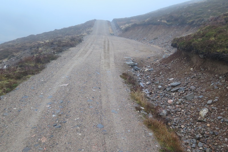
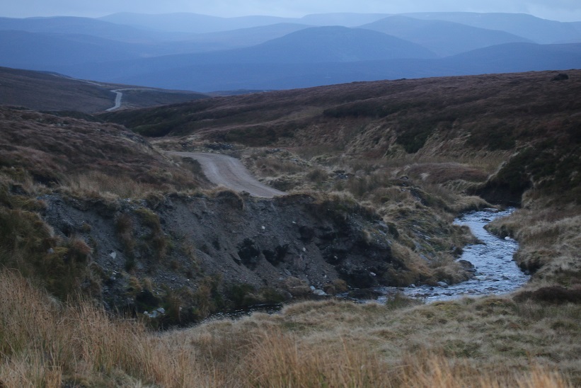
The Committee Report in my view seriously underestimates the impact of the new road on wild land and landscape. Compare the photo of the road above with the one above that which shows the existing Balavil vehicle track down to the River Dulnain. The construction of a zig zag road here will have an incomparably greater impact than the current erosion. The fact, which the Committee Report fails to remark on at any point, is that roads are far more visible than tracks eroded by ATVs, however much the damage close up. You can see this from the photo of the current endpoint of the Balavil Rd where an upgrade was approved under the Prior Notification System in 2016 (see here)
Constructed roads create harsh lines across the landscape which are highly visible and also therefore introduce an obvious element of development into Wild Land Areas.
The Report’s consideration of Wild Land issues ignores all of this. It states that “The route has been there for many years” without taking any account of the differences between routes, tracks and roads. It dismisses the need for a proper assessment of the cumulative impact on Wild Land and omits to tell Board Members that Highland Council Policy 61 on landscape explicitly refers to the need to take account of the cumulative impact of developments on Wild Land:
Representations have objected that additional assessment of cumulative effects other tracks on the Wild Land Area is required. However, SNH and the CNPA landscape advisor are satisfied that the assessment follows SNH’s best practice guidance and that it is sufficient to assess the impacts of the proposal.
The absence of any map showing all the roads into the Wild Land Area around the Dulnain or the locations from which this new road could be seen reflects this assessment failure.
Instead officers justify a new road into the Wild Land Area as follows:
“As the estate’s established route to its northern end, officers’ opinion is that the estate will continue to undertake legitimate management and will therefore have a demonstrable operational need to access its northern parts. The estate does not control an alternative access. Officers’ opinion is that a carefully constructed track, designed to minimise impacts on the landscape and surrounding habitats, will in the long term have less significant impacts on the landscape character, experience of wildness and of the Wild Land Area than the existing eroded and braided route. Conditions on the size, appearance and construction methods are proposed to ensure the constructed track’s landscape and visual impacts are minimised.”
What this in effect argues is that new roads are justified anywhere an estate can argue operational needs. Its worth noting that, according to the CNPA estate map, Balavil extends west of the River Dulnain and on this argument if the estate decided to “extend operations” there that would justify a new road which penetrates even further into the Wild Land Area. Its also worth noting that if sheep are introduced as proposed, stock fences are likely to be required to stop them wandering onto neighbouring estates. Instead of wild land, farmed land. In other words, this development will facilitate further development. How does that safeguard Wild Land as Planning Authorities are required to do under National Policy?
What is the “legitimate management” that requires a road?
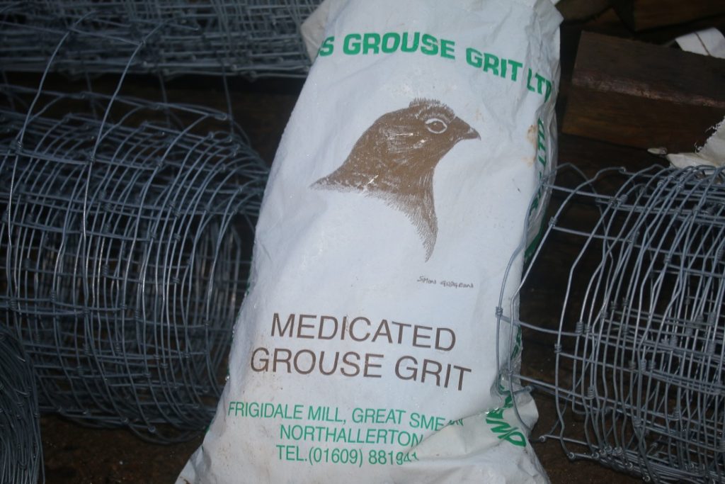
The Committee Report does not explain clearly what the “legitimate management” and “operational needs” of the Balavil Estate are: “the track is intended for a variety of estate uses, including the main sporting use of the estate and an associated sheep grazing regime”. Its unclear whether the main sporting use in the Dulnain catchment will be deer stalking or grouse shooting. While strangely the Balavil Estate makes no mention of grouse shooting in the reasons it gave making the application which were set out in the supporting statement, all the evidence on the ground (dozens of traps and feeding stations for medicated grit) is that the main intention of the estate is to intensify grouse moor management.
This raises serious questions about whether the road will be used to promote land management that is compatible with the National Park’s Statutory objectives and aspiration for landscape scale conservation set out in the National Park Partnership Plan? I would contend that an intensification of grouse moor management, the farming of grouse, is NOT compatible with those objectives or indeed with keeping wild land wild. Will this road be used for muirburn, which will destroy vegetation and soils and increase the flood risk down the Dulnain? And how does the Park know it won’t be used to persecute raptors – the Monadhliath is probably the single worst place in Scotland for such persecution? The Committee Report doesn’t say. Its written from a narrow development planning perspective. The challenge for the CNPA is unless it finds a way of integrating the Planning System into wider considerations about land-use, it will totally undermine its own presumption against hill roads.
The Committee Report also refers to deer stalking and any reduction in deer numbers would support the aspirations set out in the National Park Plan. There are no guarantees however that will happen here and, even if it did, it appears pointless to reduce numbers of deer if one of the purposes of the road is to increase the numbers of sheep. What’s more, Balavil is part of a much wider Deer Management Group and cannot reduce deer numbers on its land alone. It needs to work in concert with others and, were it doing so, could use neighbouring estate roads.
All this raises doubts about the Committee Report’s assertion that a new road is needed for operational reasons. Why cannot the Wild Land Area be left as it is?
The wider context
A number of objectors have made constructive suggestions to the CNPA that these new roads are unnecessary. Balavil could use the roads on neighbouring estates where necessary. The CNPA could also use its byelaw making powers to prevent damage by ATVs which would remove on major argument for this new road. Several of the NGOs in commenting have offered to work with the CNPA and the estate to develop these wider solutions.
The response of officers in the report is to these suggestions is:
Objectors have also suggested that the CNPA should introduce byelaws preventing the use of ATVs in the area. There would be many challenges in bringing such measures into place, and no certainty that an attempt to would be successful, but in any case, the possibility would not be a relevant planning consideration.
While the possibility of using its powers to control use of ATVs is not a material planning consideration in this case, unless the CNPA develops mechanisms to control their use it will be faced by its officers bringing back report after report recommending the approval of new roads because of ATV damage.
The CNPA need to develop a suite of mechanisms, not just planning, to address vehicle use and land management issues. The Planning Committee members, however, would be quite justified in rejecting the planning application for 5k of new road on landscape and wild land grounds until such time as new mechanisms are developed. Meantime, allowing current ATV use to continue will in the medium term be far less damaging than approving this new road tomorrow.
Addendum – examples of lack of balance in the Committee Report
There are a number of statements in the Committee Report which, for whatever, reason in my view do not represent the whole picture and are therefore biased. Below I give some examples:
“The CNPA provided advice that the applicant has responded to in their application.”
The Report does not say how the Applicant responded. In one case, at least, the applicant rejected CNPA officers advice. This was that the road should take a higher line along the Allt Ruighe na Roige above the Raitts bothy to reduce damage to the peat bog in the floor of the glen. The Estate rejected that advice on landscape grounds, maybe rightly so, at which point CNPA staff appear to have decided the damage to peat was acceptable after all. The wider point is that the Committee Report gives no consideration to alternative routes.
The application is entirely within Highland Council area, with only the southern 1.4 km of the 5km route within the Cairngorms National Park.
In fact one third of the proposed road, 1.4km compared to 3km, is within the National Park boundary
The route of the proposal is marked on current Ordnance Survey maps as a footpath
Its true there is a footpath marked on OS maps and this appears to originate from the old stalking path which was NOT marked on older versions of the OS maps. The delineation of a path could have been used as evidence to show that there was not a continuous track to the Dulnain as claimed.
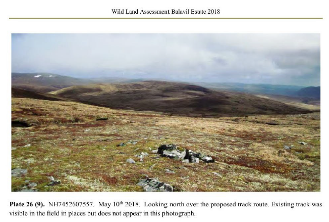
The repeated use of this line by vehicles over many years has created a route that appears in places as a heavily rutted line, often braided where the ground conditions are very soft; in other places much as a constructed vehicle track would appear, where a stone running surface has been exposed on higher ground with thinner soils, and in areas of deeper peat hags, as a route cut into the peat. Some sections have been repaired or maintained in the past to stabilise the route. It is clearly a long-established route for estate vehicles with sections of route that would be hard to distinguish from some other constructed tracks in the National Park.
This is totally misleading. The photos of the eroded track in the Wild Land Assessment bear very little resemblance to constructed roads, some are worse (deep ruts in peat hag) and some a lot better (as in photo above). The statement appears to be an attempt to persuade Committee Members that a constructed road won’t be much different from what is already there.
Scottish Planning Policy (SPP) and the National Planning Framework recognise Wild Land Areas as nationally important assets “which are very sensitive to any form of intrusive human activity and have little or no capacity to accept new development”. SPP also explains that in Wild Land Areas “development may be appropriate in some circumstances. Further consideration will be required to demonstrate that any significant effects on the qualities of these areas can be substantially overcome by siting, design or other mitigation”. Wild land Areas are not a designation.
This appears to be arguing that despite National Policy on wild land because Wild Land Areas are not a designation they carry very little weight.
SNH have concluded that the proposed track will not impact on the River Spey SAC. They also agree that the track could be constructed in a way that would avoid unacceptable impacts on the qualities of the Wild Land Area, acknowledging that the existing ATV route already creates a visual scar along the line of the proposal that is likely to become larger and more permanent through continued use.
SNH did however say that the new road would have an adverse impact on Wild Land, its just in their view this could be kept in the realm of acceptability. That is not mentioned nor is there any attempt to assess whether this judgement was reasonable or not.
CNPA Landscape states that there will be a locally significant landscape and visual impacts in the short to medium term (where the track crosses deep peat and ascends steeper slopes) along its full length. There will also be some adverse effects on the wild land experience and special landscape qualities within the National Park, as well as greater impacts on the Wild Land qualities beyond the National Park (within a remoter part of the Wild Land Area) in the short to medium term. However, it is concluded that in the longer term these impacts will not be significant if the track is constructed using best practice. The advisor agrees with the conclusion of the applicant’s Wild Land Assessment, that the effect of the proposed track on the Wild Land study area will be ‘not significant’ and unlikely to have an impact on the wider Monadhliath Wild Land Area. The advisor identifies a number of detailed suspensive conditions that are required to achieve that outcome.
The interesting question here is whether any new road could impact on the Monadliath Wild Land Area? For this statement to be meaningful, it would need to point to unacceptable developments. The fact that staff have not identified the proposed zig zag line into the Dulnain as unacceptable suggest that within this reasoning they would have endorsed any development. The problem is CNPA staff see their role as minimising the impact of developments rather than deciding whether they are acceptable in the first place.
Policy 3: Sustainable Design of the Cairngorms National Park Local Development Plan 2015 states that new development in this context should minimise the effect of the development on climate change in terms of siting and construction, use material and landscaping that complement the setting of development and create opportunities to further biodiversity and promote ecological interest. In the context of this application, the proposal is intended to prevent further erosion and damage to peatland habitats, reducing the release of carbon stored within it and to stop current and prevent further damage to surrounding habitats. Subject to the approval of detailed construction methods that can be secured through condition, the proposal complies with Policy 3: Sustainable Design of the Cairngorms National Park Local Development
There has been no assessment of the carbon imprint of constructing a new track or of what area of land will be restored if the road goes ahead. There is no mention of the fact that the creation of this road may actually increase ATV use or that without mechanisms to control ATVs the CNPA cannot guarantee any land will recover.

A well argued case, Nick. As you point out the problem is the biased Committee Report with its economies with the truth and the twisting of arguments. Given the way the report was written, it did not surprise me that the CNPA Head of Planning presented to Committee and probably wrote most of the report.
The problem now is the very dangerous precedent created by this terrible decision. It is now ‘open season’ for estate owners to arrange for ATVs to repeatedly run over routes they would like to make into estate roads, making sure that they drive in the same tracks to erode the ground. It would seem that little or no justification for the new road is needed, just that they have deliberately created an eroded partly rutted track and that they say they need a new road.
The consultation draft of the Local Development Plan covering hill track now looks like a few ineffective platitudes – or dare I say ‘window dressing’ by CNPA. As an aside, I downloaded the consultation draft of the LDP tonight, had a very quick look at one area of interest for me (Grantown on Spey) and within minutes found numerous ‘schoolboy’ errors in the document and in the letter sent to me, as my property shares a boundary with one of the developments. If CNPA is making silly obvious errors in one small part of this important document, what trust have we in the rest of it!
Hoping to put out post this week on Committee decision but there were positives, 6 Board Members voted against recommendation, which given number new Board Members who might not be sure of their ground challenging officers, was encouraging
Yes, that is encouraging, but as I think I have said before, the Board needs to give clear guidance and leadership to the CNPA Planning team to ensure that the intent behind planning policies is followed and that CNPA avoids finding ways of twisting the argument to get round the policy when it appears to suit them. This is an issue of trust – if the CNPA wants more public engagement in its policies, then it needs to avoid stating one thing in its policies and plans and then another when challenged with a controversial planning application.
I appreciate that the CNPA Board has many new members and it will take time to see what changes (if any) they make to create a real National Park and not one which has the look and feel of an Enterprise Agency.