
Last week Community Land Scotland, who have the ear of the Scottish Government, was reported in the Herald as claiming “Rural communities are being “airbrushed” out of Scotland’s rugged landscapes by policymakers who care more about maintaining an artificial wilderness” (see here). One of CLS’s central arguments is that protection of wild land is preventing development in the Highlands. The evidence from the ground does not support this as I was reminded on a visit to Torridon over the weekend where policy makers have allowed run of river hydro schemes to wreak havoc on one of Scotland’s most special landscapes for almost no community (or carbon) benefit. This post once again, following my posts on the Glen Etive hydro schemes (see here) and (here), strays outside Parkswatch’s normal scope, which is to scrutinise what is going on in our existing National Parks rather than places like Torridon that deserve National Park status.
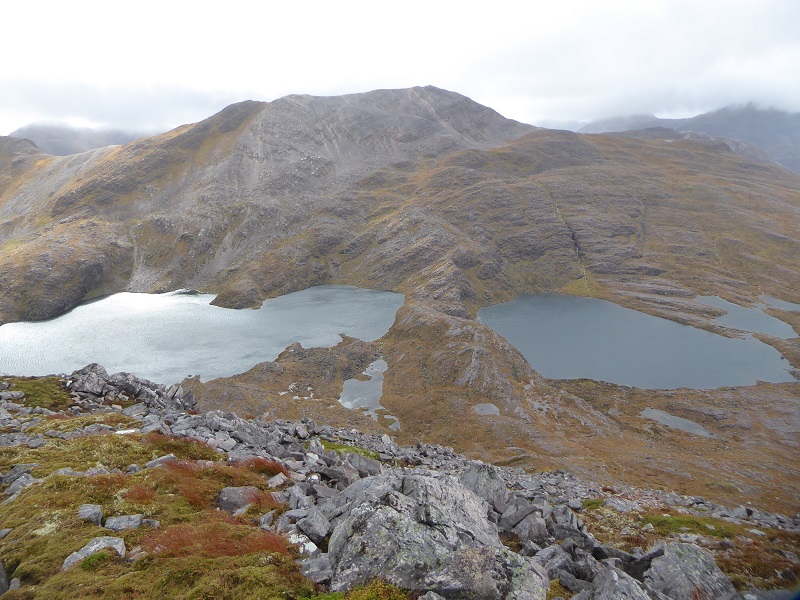
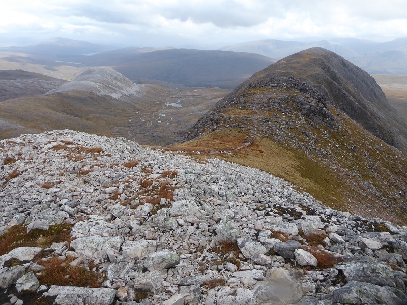
I was staying at the Ling Hut and had not walked in the Coulin “Forest” for far too long. I had forgotten quite how wild and rough it is until dashing up Sgurr Dubh on the Friday evening and trying, unsuccessfully, to get across to Sgorr nan Lochaine Uaine before dark. On Sunday, a wild and windy day, I traversed that hill over to Beinn Liath Mhor before being blown east along the ridge. I had had a mind to descend to the footpath, an old Right of Way, between Achnahellach and Coulin but changed both mind and direction when I saw the new and unmistakeable hydro scar.
I had come for a break from campaigning but, once seen, the scar was almost impossible to ignore and I can only describe the visual impact of this scheme on the landscape as brutal.
 I guess my sensitivities were heightened from having travelled across an area of dramatic scenery, threaded my way down through crags not marked on my old OS Map, slipped and slithered across the moor and seen almost no sign of humanity apart from the path along the Beinn Liath Mhor ridge. The shock would not be quite so great approaching this scheme from below.
The Easan Dorcha hydro scheme lies within the Wester Ross National Scenic and Wild Land Areas. Our National Planning Framework for Scotland claims that: “National Scenic Areas and National Parks attract many visitors and reinforce our international image”.
So how could this be allowed to happen?.
The developer, Hydroplan, said in their Construction Method Statement, which is available on the Highland Planning Portal (see here) that:
“9.6 Landscaping
The ground will be graded to screen the wing walls of the intake structure where possible, by using riprap or rock boulders and surplus excavated spoil and turf and following any recommendations from the ECoW (Ecological Clerk of Works) after construction is completed.”
AND
4.3 Stripping and storing materials
- Careful side stripping of top peat from all areas to be disturbed. Depth of strip to be at least 250mm but to be determined on site depending on ground conditions. Peat and turf to be lifted and stored at the edges of the construction corridor in one operation where possible and retained as intact turfs where feasible.
- Do not mix sub-soil with top-soil or peat.
- Use defined top peat storage areas to avoid mixing of materials and double handling where possible, with top peat stored ‘vegetation or turf side up’ to avoid desiccation.
etc etc etc.
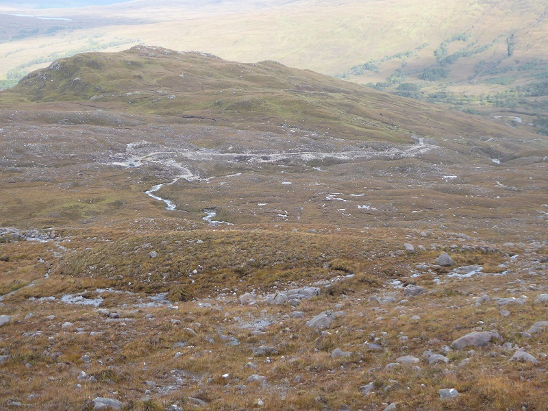
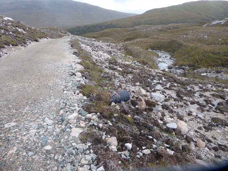
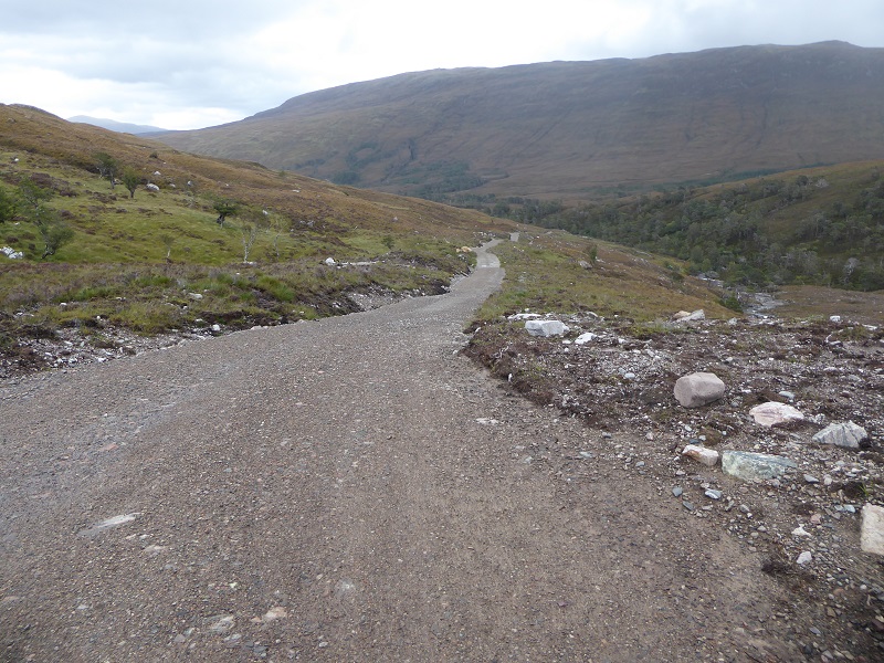
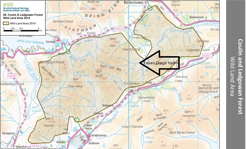
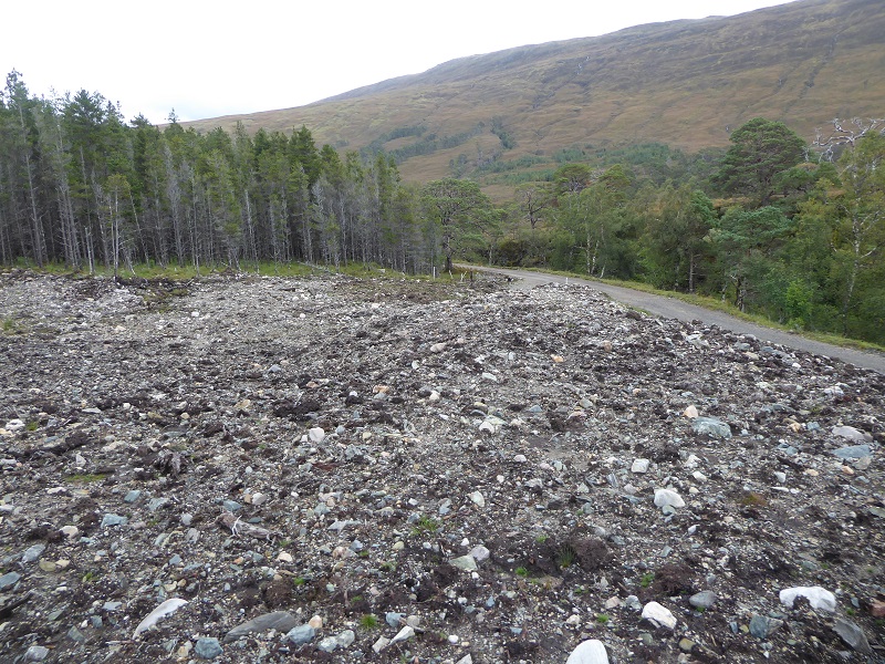
The evidence shows that much of what was promised to reduce the landscape impact of the scheme has not been delivered. Instead, further completely unnecessary damage has been done to the ground in an attempt to find peat and vegetation to cover up the mess.

A similar story to what is going on in our National Parks.
The section of the planning assessment dealing with visual impact is worth a read to understand how little value our planning system places on landscape and wild land and for its wishful thinking:
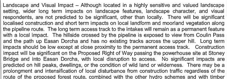
The evidence on the ground shows this assessment and its conclusion were fundamentally wrong.
Apart, that is, from the statement that the “hillside crossed by the pipeline is exposed to view”.
Unbelievably, Hydroplan’s assessment of the zone of “visual influence” – planning spin for areas from which a development might be visible – ONLY assessed the “visual influence” of ONE intake and not the track. The two intakes, though bad enough, are relatively tucked away. Had the map below showed the areas where the track could be seen the “zone of visual influence” would have probably doubled and clearly taken in a huge chunk of the National Scenic Area
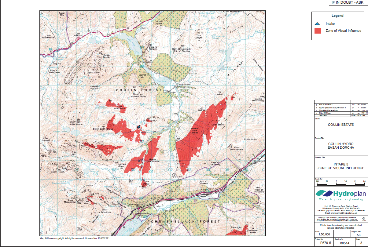
Why neither Highland Council nor SNH, who also commented on the application, failed to question this totally inadequate assessment is unclear. In relation to the track, besides the failure to assess its impact on landscape and wild land, there has then been a further failure to ensure it met the standards promised by the developer and, by implication, the Coulin Estate.
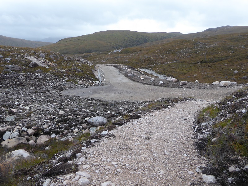
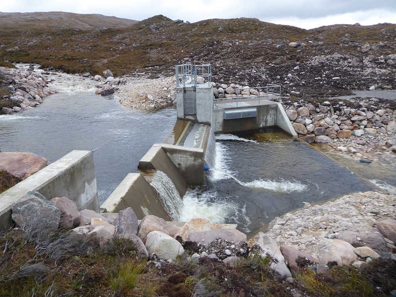
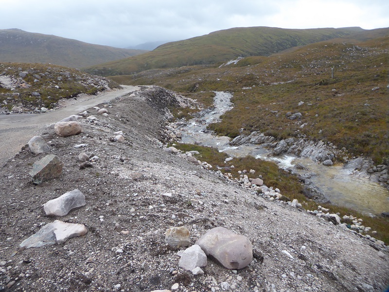
700m of new permanent tracks will be required to access Intake 5 and Intake 6. The track will be constructed as 3.5m wide construction tracks, similar to the powerhouse access,however it will be reduced to a 2.m wide ATV track with a central green strip of vegetation” (Extract from Hydroplan’s Construction Method Statement).
The delegated planning report and SNH’s response to the application shows there was no proper assessment of either the impact on the National Scenic Area or the Wild Land Area:
Extract of assessment pro-forma included in the delegated report by officersThe development was assessed as being in accord with every single one of Highland’s Planning policies and all National Policy too with not a single area of conflict. This is clearly wrong and its also clearly wrong that Highland Council, like the Loch Lomond and Trossachs National Park Authority, allows decisions about run of river hydro schemes to be decided by staff under delegated powers without any critical scrutiny.

While the Planning Decision in this case was taken before Wild Land was incorporated into the National Planning Framework in 2014 (it contains a clear presumption against Windfarms in Wild Land Areas but NOTHING was said about other developments such as hydro schemes) SNH’s preliminary guidance on Wild Land Areas was incorporated into the Highland Local Development Plan. It was ignored despite the entire scheme, apart from the powerhouse, lying in an area of wild land (the whole scheme lies within the Wester Ross National Scenic Area)..
Interestingly, SNH in their response (see here) warned about the difficulties of restoring vegetation higher up the track but did not follow this through and no-one appears to have thought that might be sufficient reason to refuse the development.
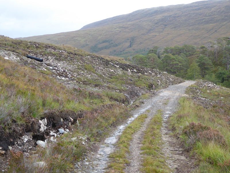
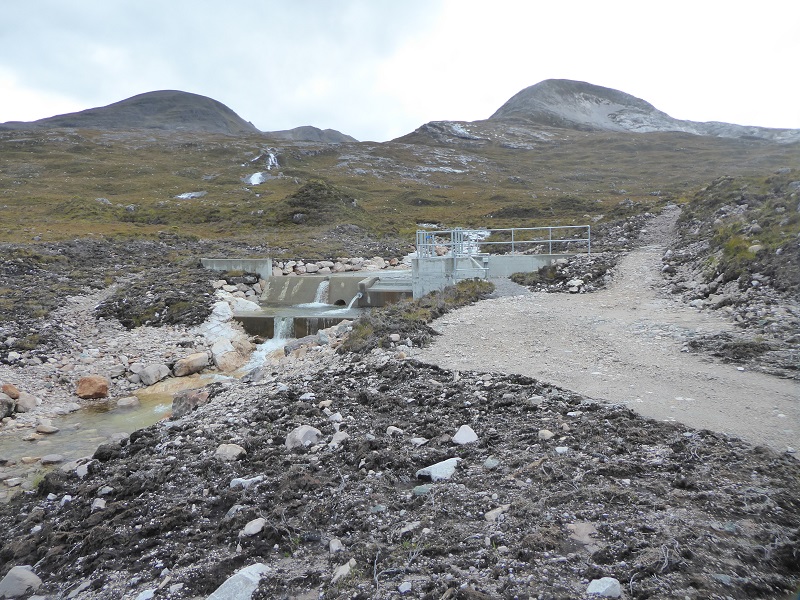
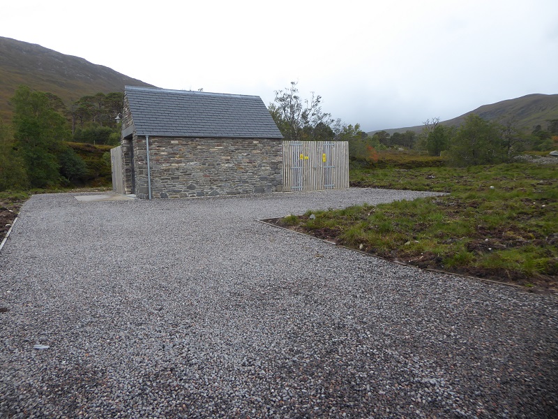
Far more attention was given in the planning application to the design and location of the powerhouse than to the intakes and track, with SNH being concerned about its impact on the Site of Special Scientific Interest and urging that the ground around it be landscaped to look natural.
“10.5 Landscaping
The ground around the powerhouse will be landscaped in such a way to ensure it is blended
into the surrounding landscape”
Apart from the large area of hardstanding, created with what appears to be imported stone, the design and location of the powerhouse is in my view quite appropriate for a National Scenic Area and edge of the Wild Land Area
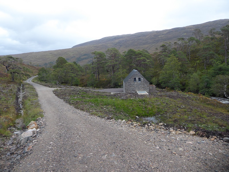
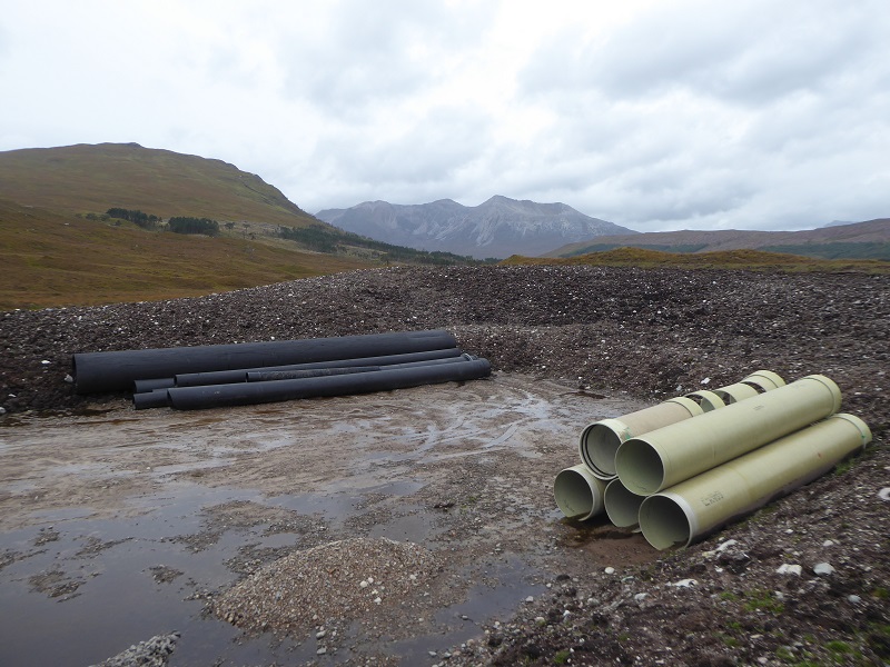
By contrast, no care and attention has been given to the appearance of the first large borrow pit, which is in the National Scenic Area:
“On completion the floor of the pit will be broken up and re-graded to an undulating, rough profile, ramping fill material up against the base of the face of the excavation. Surplus rock material in the vicinity of the pit will be removed into the pit. The base of the pit, and back face where feasible, will be fully covered with reclaimed top peat spread to a minimum of 300mm or to match the top peat depths in the adjacent area” (Construction Method Statement). Its unclear if this statement applies to the borrow pit in photo above or that featured below or both – but whatever the case, its not happened.
There was no evidence of any construction vehicles still on site so one must assume in the eyes of the estate, developer and council this development is now completely and satisfactorily finished.
As is often the case, those responsible have not even removed surplus materials……………..
What needs to happen?
I hope this post this post has shown that this development (and there are another three hydro schemes on the Coulin estate) has been an absolute disaster in landscape terms and like other such schemes will in the long term destroy Scotland’s reputation for having world class landscapes. Highland Council formally bears a large degree of responsibility for the trashing of the Highlands through approving inappropriately located, poorly designed and poorly executed run of river hydro schemes (I will provide further evidence of how they have impacted on Torridon special landscape when I revisit the area in three weeks time and have a re-look at other schemes I first visited two years ago). Behind them however is a national policy framework and culture which assumes all run of river hydro schemes are a good thing and should be developed as quickly as possible with only token consideration given to other issues.
Unfortunately, back in 2012 only one person objected to the scheme – all credit to them (see here) – and there was no response from the local community council but we should really not have to depend on people lodging objections to protect our finest landscapes. Our planners should be doing this for us. For this to happen we need:
- a much stronger national planning framework and rules in relation to landscape (which as a first step could incorporate guidance on hydro schemes, as well as windfarms, into guidance on development in National Scenic Areas and areas of wild land)
- much stronger Local Development Plans which set out a clear framework for landscape protection
- and planning staff with the time, knowledge and expertise to make good decisions (its not the responsibility of frontline staff to ensure they are properly equipped to deal with cases like this).
Behind such developments however we have landowners and developers who would appear not to care. On the way back, along the River Coulin, I pondered how the estate could have accepted this mess before coming across this sign by Loch Clair:
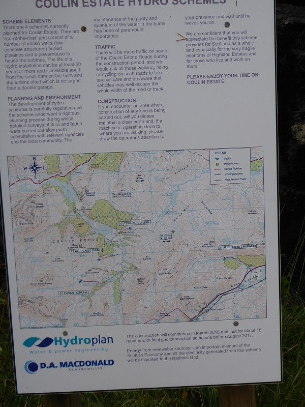
So what is the Coulin Estate and Hydroplan doing to ensure that their claim that this scheme would be “invisible apart from the small dam on the burn and the turbine shed which is no bigger than a double garage” is true?.
Instead of attributing the economic challenges faced by ordinary people living in the Highlands to Wild Land, Community Land Scotland should be challenging the myth promulgated by the Coulin Estate and others of the “fragile economy of Highland Estates”. These estates are owned by some of the richest people in the country, nay the world, and hydro schemes, which are paid for by the public (that’s you and me) in higher fuel bills, are adding to their wealth with almost no benefit to the local community (the four Coulin hydro schemes will need no more than 1 part-time employee to keep them going) or the environment.

I’m afraid that our highland planning authorities and SNH far too often these days treat such planning applications as desk study box ticking exercises. As long as the applicant puts in the appropriate words in the planning application, the application will more than likely get accepted. There is no longer any real critical assessment of the supporting technical documents and certainly precious little checking on the ground that planning conditions and method statements have been complied with. I appreciate that there are resource issues, but our planing authorities, SNH and the Scottish Government need to weaken up before our precious ‘natural’ environment and wild lands are totally trashed in the name of progress!
How is zero carbon emissions a bad thing? I work for SNH and I can ASSURE you applications arent quickly dealt with.
What you have failed to mention in your article, although the land has scars every effort has been made to rebuild the landscape around Coulin Estate. You visited the estate just weeks after completion so yes, it wasn’t going to be ideal but trees are being replanted, shrubs, nature preservation continues for both wildlife and plant life. Prior to the works beginning many experts visited coulin where many of the worlds rarest shrubs and moss are found. Where these were found the proposed planning of any buildings were moved around rare plant life. Every effort was taken in making sure nothing was ruined or removed impacting the environment.
The 3 hydro huts built are tiny, not even noticable now plant life has started to regrow. Electricity is created which is zero emission and 2 of the properties on the estate are powered by the run off hydro huts, 80% of the electricity generated is put into the national grid. All in all it is a very clean and environmentally friendly method in producing electricity from hill run off. I politely request that you revisit the sight and leave your biased opinion at the estate entrance while also including unbiased info in your write ups which are mainly made up of cherry picked info to make hyfo schemes look bad.
Yours angrily
D Tobian
Who said zero carbon emissions are a bad thing? Not me. However, if you are suggesting that the construction of run of river hydro schemes has no carbon emissions that is clearly wrong: among other things are the energy involved in the construction (bulldozing, digging holes, transporting equipment across the world – I would like to have seen all the stuff used to fabricate hydro made in Scotland not abroad), the carbon released through the concrete, excavating soils and destroying peat etc etc. While the production of electricity can offset this in places like Glen Falloch, where schemes have failed, its possible that schemes may become net contributors to global warming, contrary to policy intentions. Then there are all the environmental impacts. I am not against hydro just poorly thought out and restored schemes. I am not intending to visit the Coolin Forest in the near future but if you send parkswatch photos of the areas of concern which featured in the post showing how they look now I would be delighted to publish them and along with comments. Nick