The Allt Essan and Auchessan hydro schemes lie on the north side of Glen Dochart south of the Munros Meall Glas and Sgiath Chuil. Both were approved by the Loch Lomond and Trossachs National Park Authority in December 2014 but the Auchessan design was subseqently amended in 2015 (see here and here). While both schemes were designed by the same company, Dulas, the much larger 1.2 MW scheme lies on the Loch Dochart Estate while the 225 KW scheme lies on the Auchessan Estate.
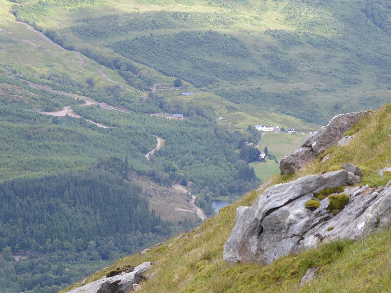
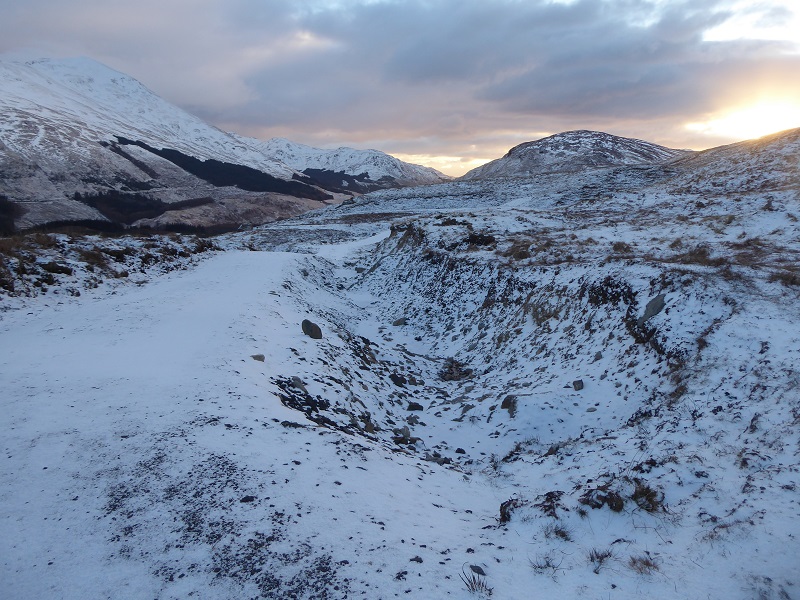
I had been meaning to visit these schemes since becoming aware of the destruction caused to the landscape by the new access tracks (photo above) while taking a look at the site of the new proposed Ben More hydro scheme (see here). I did so after attending the Board Meeting which gave the go ahead for the Cononish gold mine and just before the beast from the east arrived. While the light covering of snow and fading light did limit what could be seen, enough was visible to show up the claims the Head of Planning, Stuart Mearns, had made earlier that day: he had claimed that LLTNPA staff had learned sufficient about restoration of hydro schemes for the Board to be confident that they could successfully create a vast artificial moraine field out of the Cononish tailings in an area of wild land.

The two power houses are located a stone’s throw apart but on opposite sides of the Allt Essan which marks the approximate line of the boundary between the two estates. Had power generation been nationalised, it is likely that there could have been one shared powerhouse, instead of two. Given that some of the Allt Essan appears to lie within the Auchessan Estate boundary it is possible there was a legal agreement between Auchessan and the Glen Dochart Estate to abstract water from the burn and this may explain why they both appointed Dulas to design their schemes.

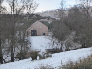
The Auchessan Hydro
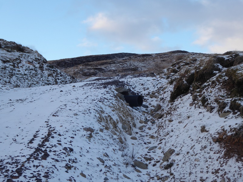
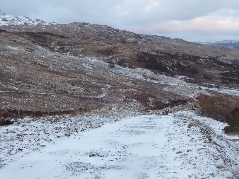
I started up the track to the Auchessan intakes. The track and location of the intakes was altered from the original planning application and the track takes a direct line up the hill:

What struck me immediately running up the track, the first section of which had preceded the hydro but has been “upgraded”, by being widened and having new aggregate dumped on the surface, is that it is far too steep:

In the lower “upgraded” section of track there has been a failure to retain and use turf to line the left hand side of the track/drainage ditch with a consequence this too will erode. Because the LLTNPA has not published the Construction Method Statement and Landscape Restoration Plan it required as a condition of the planning consent, its not possible to tell if proper plans were ever agreed and whether this is another failure by the LLTNPA to enforce planning conditions. Whatever the case, the design and execution of the work is extremely poor.
While in its Supplementary Guidance on Renewables the LLTNPA refers developers to SNH Guidance on Constructed Tracks in the Scottish Uplands, nowhere does it say anything explicitly about the angle of hill tracks. SNH’s guidance states that the angle should not exceed 14 degrees – because the evidence is any steeper than this and tracks erode. The LLTNPA, however, has rarely given any consideration to the steepness of tracks and as a consequence is creating erosion problems for the future (whatever the wider landscape impact).
“Once the track is constructed the batters are bare earth surfaces that can scar the landscape, so in order to reduce their visual impact batters must be graded in order that re-vegetation can occur.
Developers should follow best practice techniques:
* Minimise the length of the batter slopeby avoiding steep hillsides.
* Ensure that the slope of the batter is shallow enough for vegetation to grow.
* Complete batters at the time of road construction, not retrospectively.
* Preferably cut and put aside turves during construction of the road and then place these on the
batters; or leave a prepared (cultivated) batter surface to assist re-vegetation.
* Assist re-vegetation using appropriate techniques (for example the use of heather brash or native
grass seed).” (LLTNPA Supplementary Planning Guidance on Renewables)
None of these recommendations are evident in the photo above or below:

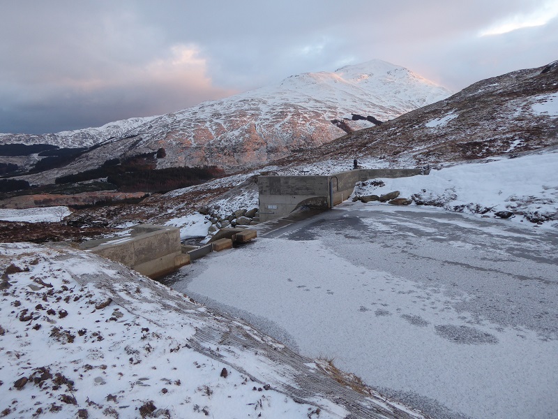
The Auchessan scheme has two intakes.

While the main intake is well located being hidden from a distance – the track, top right, is the main issue – it still does not follow LLTNPA guidance:
“If rip-rap [boulder] retention is required in the vicinity of the inundation area or the river bankimmediately adjacent to the weir, consideration should be given to the detail and use of local
rocks and boulders to minimise visual impact.”
These boulders will almost certainly never blend in with the landscape
If wing walls are required and concrete is to be used, choose a subdued colour which blends with the adjacent surroundings. A local source of boulders should be used to help screen the concrete structure.
The impact of the design in this case is relatively limited because the intake is so small (see below) but in larger intakes, such as Upper Glen Falloch, the landscape impact can be considerable.

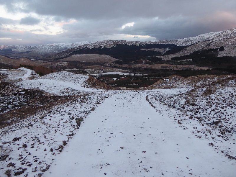
From the Auchessan track I contoured West for a few hundred metres before meeting up with another Auchessan Estate ATV track which runs along the north side of the Allt Essan:

The Allt Essan Hydro
The creation of the Allt Essan hydro access track means that there are now two tracks, one on each side of the burn.
The Delegated Report for the Allt Essan hydro scheme had this to say about the track:
The site is located within the Open Hills Landscape Character Type (LCT) and the Forested Glen Sides LCT. Sensitivities in these LCTs include development, particularly the creation of new tracks.
It is important that the track does not follow high ridges as this will be visible from the A85.
So why then does the track follow the ridge by the side of the burn?
There was no reference in either Planning Application to the LLTNPA’s guidance which staff abandoned several years ago:
It is expected that any new access tracks required for the construction will be fully restored unless there is overwhelming reason why they should be retained for the operational phase of the development.
How has the LLTNPA now allowed not just one but two tracks leading to the same location?
The landscape assessment quoted in the Planning Report was concerned about the visibility of the Allt Essan intake from a distance – and rightly so:

Little appears to have been done to ameliorate the appearance of the dam as set out in the delegated planning report which stated:
“Intake design: All visible pipes should be coloured grey to minimise visual impact [Hurrah!]. The wingwalls for the intakes are proposed as being reinforced with boulders in the concrete which could result in a very visible structure. Further detail on the finish should be agreed with the NPA prior to development. Stone facing on wingwalls can discretely hide the wingwalls within a watercourse however without a photomontage of the intakes at the locations it is difficult to adequately advise.”
Instead, there is this:

The earth screen is far too steep-sided, held together by textile and does not fit with the landscape. Here is the LLTNPA Guidance again:
“If geotextile retention is required, in order to aid re-vegetation as well as successful landscape and visual integration, attention should be paid to the detail and specification of the material applied and its ongoing monitoring and maintenance.”
Is this the sort of high standard restoration the LLTNPA believes it will deliver at Cononish?


It got worse as, not long after I started down the new Allt Essan hydro track, I realised much of it and the ground at the sides was being held together with plastic garden netting partially concealed in the snow. The LLTNPA makes no mention of plastic, which does not biodegrade for hundreds of years and then when it does poisons organisms, being used to restore ground in its best practice Guidance on Renewables but it appears to have played a fundamental role in the “restoration” of ground at Allt Essan. Time that Guidance was updated!
Were National Parks set up to do this? The gap between rhetoric and reality in the Loch Lomond and Trossachs National Park is yawning.
The track below is a motorway which carves its way around and over what was a fine line of moraine.
The Planners were concerned about the visibility of the Allt Essan track from the A85 – it is visible from there in places – but the real impact is for people out for a walk in the surrounding hills. The tracks here have changed the character of the glen. What is the point of Landscape Character Assessments if this is then allowed to happen?

While most of the track runs through forestry, a wide swathe was cut through trees to create the pipeline with the result it is highly visible. Could the LLTNPA not have required a narrower construction corridor? Here is the Park’s own Guidance again:
Where tracks are to be retained, especially in locations which are sensitive in terms of landscape impact, they should be restored from the specification required for construction
vehicles and be reduced in width to the minimum required for ongoing quad bike (or similar) access
As an illustration of the inconsistency of the LLTNPA as planning authority, in the case of the Auchessan track a requirement was set to narrow the track to 2m and 2.5m at bends (as per what the LLTNPA says is best practice but without any grass strip down the middle) while in the Allt Essan Scheme a requirement was set to narrow the track to 3m after construction:
Auchessan: Tracks – The strategy of cut and fill should be used for the reinstatement of the permanent track to ensure that the track is successfully narrowed. Path width should be 2.0m unless otherwise agreed by the NPA.
Allt Essan: 23. Restoration of permanent access track: Within 12 months of the hydro electric scheme hereby approved being commissioned or brought into use, the new permanent access tracks to the powerhouse and intake shall be restored to a maximum width of 3 metres.
This failure to ensure a consistent approach to new hill tracks is part of a wider failure by the LLTNPA as Planning Authority to ensure consistent standards are applied to developments in the countryside. Neither senior management nor the LLTNPA Board appear to have any interest in what is going on. I sympathise with the staff: there appears to be no consistent guidance or framework for them to work within and the only thing their management appear to care about is that applications are processed within agreed timescales (the key planning performance indicator required by the Scottish Government). One needs to remember that Gordon Watson, the current Chief Executive, was formerly Head of Planning and it was under his watch that planning standards were allowed to slide. One wonders what Simon Jones, Director of Conservation, thinks of all of this but he is too busy measuring the micro impacts of campers on the loch shores to have time to see what is going on at the landscape scale.
The impact of hydro schemes on the landscape of the National Park
And its what is happening at the landscape scale which is what matters even more than the poor design of these schemes. The officer’s delegated report into the Allt Essan scheme did consider the cumulative landscape impact of hydro schemes in Glen Dochart:
In terms of Landscape and Visual impacts the nearest scheme would again be the Auchessan hydro. This is to be located within the Farmed Glen Side Landscape Character Type (LCT), whereas this scheme is located within Forested Glen Sides LCT and Open Hills LCT. The Allt Coire Chaorach which would be located 1.5km across the glen is within the Forest Upland Glen LCT. Benmore would be at 4km within the Open Glen LCT. Due to the nature of the developments, with buried pipeline routes and the spread out location of intakes and powerhouses as well as intervening landforms mean that there should be minimal cumulative effects on landscape character. Therefore the conclusion of the ER that no material cumulative landscape effects are predicted as a result of the proposed development with any other operational and consented hydroelectric developments is agreed. The location of the neighbouring proposed scheme “Auchessan” within a different LCT also means that there would be minimal cumulative impact in landscape and visual terms, despite the two schemes being located in close proximity.
The conclusion appears to be that because some of the schemes are in woodland, some in farmland and some in open country there is NO cumulative impact. In fact, the assessment completely fails to mention the impact of the tracks which is far far greater then the pipelines, although, weirdly, in the Auchessan scheme assessment, the tracks were taken into account: “Sensitivities include development which will detract from unspoilt and scenic qualities. This includes the creation of new permanent access tracks.” The Allt Essan assessment also fails to mention the proliferation of forestry tracks in Glen Dochart over the last thirty years and how the hydro tracks add to this:

The overall conclusion of the assessment is that the view from the top does not matter:
In terms of cumulative visual effects there will be combined cumulative view of the proposed development with Auchessan, Allt Coire Chaorach and Benmore hydro schemes from areas at higher elevation including Ben More, Meall Glas and Sgiath Chuil, as acknowledged in the ER. However it is agreed that the distance and scale of the proposed development would ensure that any combined or sequential cumulative effects would only occur as minor features within the landscape and cumulative visual effects would be limited.
What a contrast between the approach taken by the LLTNPA and that taken by the Munro Society which is currently cataloguing the damage being done to views from the summits of hills.
What needs to happen
As long as the LLTNPA Planning Department is allowed to carry on as they are, with staff approving and failing to enforce planning conditions on a delegated basis, the destruction of the landscape in the National Park will continue. I would like to see four things happen:
- First the LLTNPA needs to engage with outdoor recreation and landscape interests in the National Park about what is going wrong instead of trying to persuade the public all is well. A fantastic example of what is going wrong was Head of Planning Stuart Mearn’s guest piece in the last Scottish Mountaineer on “Hydro in the Hills” (see here) which failed to mention landscape once.
- Second, the LLTNPA needs to commission an independent report into the landscape impact of hydro schemes, both at individual and cumulative level, in the National Park with a particular focus on hill tracks and the effectiveness of restoration measures
- Third, the LLTNPA needs revise its guidance on renewables to take far more account of the landscape impact
- Fourth, the LLTNPA Planning Committee needs to once again take decisions on hydro schemes and not delegate such decisions to staff. There is plenty of evidence that the earlier schemes, where the Board was involved, were of a generally higher standard and in many cases, such as Glen Falloch, required construction tracks to be removed.

I know this is a serious article – but it’s hard not to love that Scottish countryside at this time of year – helped by your excellent photos 🙂 … of course this just highlights why its important to look after it – which I guess is the serious part.
Campers can not camp on a small bit of ground near water, but the LLTNPA aloud large amount of land two be ripped up.Were is the justice. Perhaps solicitors can use this poor management by the LLTNPA in defence of campers and camping
The land was out of sight from any solicitors or llatnp staff homes ,brown envelope job .however campers and pretend fishermen do spoil views from solicitors and llatnp homes
I walked up the Auchessan track when the scheme was under construction – or should that be “destruction”? – on my way to climb a Corbett. I was horrified at the industrial-scale bulldozing that had taken place, and your report suggests it hasn’t got any better. Two walkers ahead of me did not bat an eyelid, break stride or interrupt their conversation, making no mention of the devastation around them. No wonder the LLTNP gets away with murder.
This land is private and what right do you have to question the Scottish farmers and landowners right to diversify based on the fact you don’t like the look of tracks. How did you get to Scotland for your walking jolly, along a massive road, perhaps via a Victorian rail route? Get some presepective and remember that we face much bigger challenges with climate change. The Scotland you walk now will change unless we take action. Be nicer and help the Park deliver it’s climate objectives rather than berate them all the time. Be kind and actually help rather than stare and criticise.