 Following my post about the upgrade of the existing hill roads at Balavil (see here) , this post takes a look at the Balavil Estate’s proposal to drive 5km of new road into the heart of the Monadliath Wild Land Area. In December the Cairngorms National Park Authority Planning Committee delayed the application to allow it to be advertised properly (see here). The new deadline for comments on the Planning Application is Thursday (see here for all papers and to respond using the comments facility).
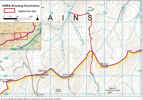
The Application is complicated because, while the proposed road lies entirely within the Monadhliath Wild Land Area and starts within the Cairngorms National Park, much of it lies beyond the Park boundary. Highland Council have agreed that the CNPA should decide the entire application but in doing so they need to determine the application with reference to both their own and Highland Council policies.
The new road is being justified, in part, as a means of reducing existing damage from All Terrain Vehicles. If this argument is accepted it would allow landed estates to construct new roads almost anywhere in our hills and undermine the CNPA’s stated policy “presumption against new constructed tracks in open moorland”. All an estate would need to do is first damage vegetation through ATV use and then follow this up with a Planning Application for a new road. In determining this application the CNPA therefore needs to take a much more strategic look at how vehicles are used in the management of the National Park than it has done to date.
Balavil and the hill roads on neighbouring estates
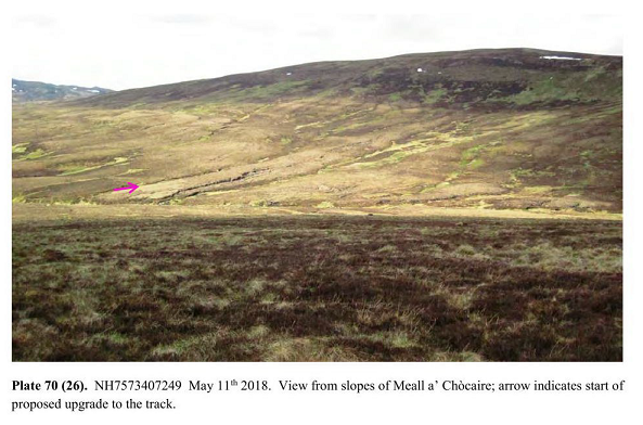
Balavil, like the estates neighbouring it on the west side of Strathspey, is an unusual shape, long and thin. These estates rise from the bottom of the strath up over the eastern ramparts of the Monadliath, down into the Dulnain and then up to the watershed to the Findhorn on the far side. The shape is important because if each estate were to be allowed their own road for “land management purposes” the whole of this part of the Monadliath Wild Land Area would soon be traversed by roads. What the report produced for the Planning Committee (see here) failed to consider was the context, the other tracks that cross the Monadliath into the Dulnain and beyond.
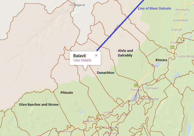
Both the Pitmain Estate and Dunachton Estate, on either side of Balavil, have roads which descend to the Dulnain only a short distance from the proposed endpoint of the new Balavil road. These other Estate Roads are not shown properly in any map within the Planning Application (or the Committee report – see top map). They should be.

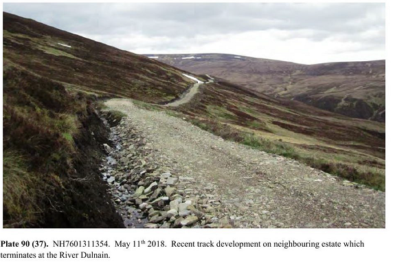
There has been a road on the Dunachton Estate over to the Dulnain for some time (its shown on my OS Map from 1974). In 2015, Highland Council approved an extension under the Prior Notification System (the estate claimed it was for agricultural purposes) which curled round the north side of Carn Dulnain:
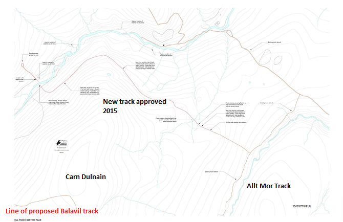
The end of the proposed Balavil road would lie less than a kilometre from the Dunachton Estate roads as shown on the map above and is also close to the older Allt Mor extension. The Pitmain roads are not much further away.
If the estates co-operated, there would be NO justification for this new road, as Balavil could simply use the Pitmain and Dunachton tracks for land management purposes.
Its the job of the Cairngorms National Park Authority to ensure estates co-operate on land-management. If this had been happening, there would have been no need for the Planning Application, as Balavil could have used neighbouring estates’ roads. The CNPA should reject the Balavil Planning Application and tell the estates they need to start to working together to achieve the strategic objectives of the National Park. The alternative is to undermine their policy presumption against new hill roads.
Land-use on the Balavil Estate
Taking this approach would mean that the CNPA would not have to address the contradictions in Balavil’s claimed justification for the new road and the challenges this poses to their policy “presumption against new hill tracks”:
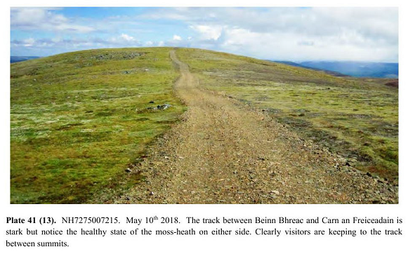
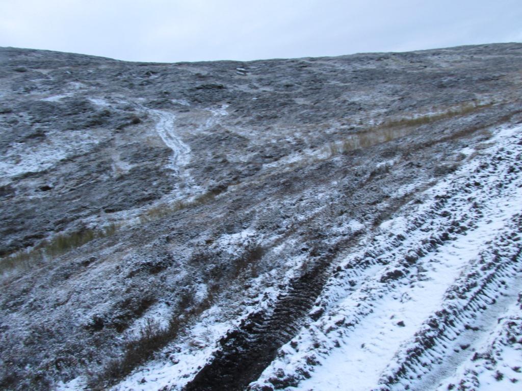
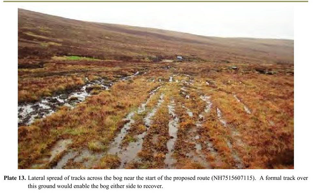
The claim that there is a requirement “for the remaining existing track to be repaired” is nonsense. There has never been a constructed road here, unlike that up to the Raitts bothy which was enlarged in 2017. Instead a variety of All Terrain Vehicles have been driven all over the hillside, including in the direction of the River Dulnain. That ATV use has created a series of tracks.
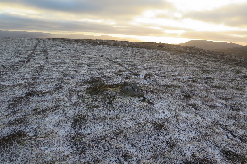
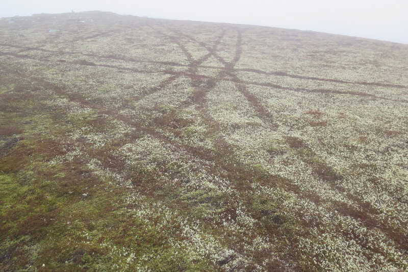
Most of the erosion has been created by the estate’s use of All Terrain Vehicles. Depending on the ground and levels of use the impact has varied from destruction of Cladonia lichens (above) to destruction of all vegetation:
As long as estate staff, stalkers and grouse shooters want to drive everywhere, there will be a multiplicity of tracks. This issue will NOT be solved by the creation of a new road. Indeed, by making vehicle use easier, it may encourage even more ATV use. If the CNPA is really concerned about damage by ATVs, as it should be, it should use its byelaw making powers to control off-road vehicle use. Otherwise it will set a precedent that will enable every landowner to apply for new roads on the basis this could “reduce” damage caused by ATVs.
The second major contradiction in the Estate’s justification for the new road is between its stated wish to reduce deer numbers for conservation reasons but at the same to increase numbers of sheep. That is just incoherent and replaces one herbivore by another. Landowners are already meant to be co-operating to control deer numbers, which is essential if the CNPA is to meet its conservation objectives, in any case. Given the long thin nature of the estates on the eastern side of the Monadliath, its impossible for any estate to reduce deer numbers on the land it owns or to manage sheep there without working with its neighbours. If Balavil could use the Dunachton and Pitmain roads, whether for deer culling or sheep management, there would be no need to add yet another eyesore to those already created
The third contradiction in the justification is the claim that somehow this new road enhances the right to roam. In fact, what these roads do is detract from the Wild Land Experience as the River Dulnain is already readily accessible.
Nowhere in the justification is any mention made of grouse moor management, although from the number of butts, traps and medicated grit stations this is currently one of the primary reasons vehicles access the area. The shooters could of course walk.
The impact on Wild Land and landscape
The land traversed by the proposed new road is not statutorily protected by any designation (such as National Scenic Area of Site of Special Scientific Interest) but does lie within the Monadliath Wild Land Area.
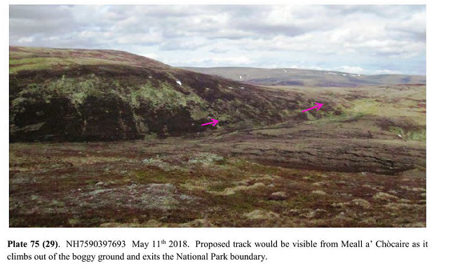
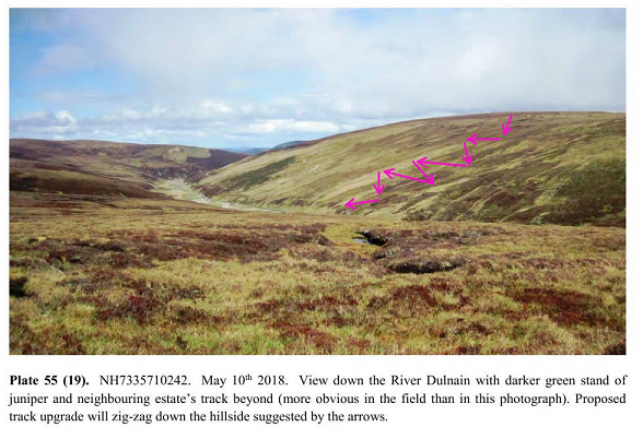
The Planning Application contains a Wild Land Assessment, which contains many photos (well worth a look) but muddles up statement of fact, such as the locations from which the road would be visible, with judgements about its acceptability. The Assessment generally argues that because the new road is rarely visible from afar, the impact on the Wild Land experience is negligible, and dismisses the cumulative impact of the existing roads over to the River Dulnain. At the same time it argues the opposite, that a new road would reduce the adverse impact that ATV erosion, which is only visible very close up, has on the Wild Land Experience. This is wrong.
Photos from the assessment show that the “local” landscape impact of the track, quite apart from the existing erosion, will be significant and somewhere that currently feels wild will be seriously affected by the new road:
In the Report which was due to be considered by the Planning Committee (link above) there was no proper appraisal of the impact the proposed new road would have on Wild Land. There was no mention of the policy presumption against new hill tracks adopted in the National Park Partnership Plan, the overarching document which is supposed to guide all the CNPA does, or of the statement in the new draft Local Development Plan:
4.76 The Plan starts from the position that there should be a presumption against new tracks constructed in open moorland areas. However, it is inevitable that as management of open moorland and hill ground changes for different objectives, there will be instances where the existing and extensive network of tracks does not provide the vehicle access desired for management. The Plan also provides for the construction of well-designed new tracks where they are part of a programme of works that enhances the special landscape qualities of the National Park.
While that Plan has still to be approved, the statement that “there will be instances where the existing and extensive network of tracks does not provide the vehicle access desired for management” is very relevant to this Planning Application. Since there is already an extensive network of roads to the Dulnain, under this policy, the new road would have to be rejected.
In fact the CNPA’s current approved policy, which still takes primacy when it comes to determining planning applications, also gives every reason for the CNPA to reject this application:
POLICY 5: LANDSCAPE
There will be a presumption against any development that does not conserve and enhance the landscape character and special qualities of the Cairngorms National Park including wildness, and in particular, the setting of the proposed development.
Proposed development that does not complement and enhance the landscape character of the Park and the setting of the proposed development will be permitted only where:
a) any significant adverse effects on the landscape character of the Park are clearly outweighed by
social or economic benefits of national importance; and
b) all the adverse effects on the setting of the proposed development have been minimised and mitigated through appropriate siting, layout, scale, design and construction to the satisfaction of the planning authority.
The Committee Report made no attempt to justify the new road on the grounds it will have “social or economic effects of national importance”. It simply summarises CNPA policy, leaving out this key point, but then makes no appraisal of how the policy should apply in this case:
“Policy 5: Landscape presumes against development which does not conserve and enhance the landscape character and special qualities of the National Park and in particular the setting of the proposed development.”
In respect to the Highland Local Development Plan, which is now very out of date (2012) and preceded Scottish Government policy guidance on Wild Land, the Report justifies the development on the basis that:
“The impacts of the proposed track are considered to be less than those caused by a repeatedly driven ATV route on the basis that the construction will be a high standard and limited to narrowing the track sides to 2.5m”
That argument is a license to create tracks everywhere and is NOT I believe what Highland Council policy intended. There is no reference to the Highland LDP statement on Wild Land:
“Prior to wild land being identified, proposals that may have an adverse impact on the wild land resource should undergo an assessment process…………….The assessment should include consideration of impacts that occur cumulatively as well as individually; they may occur incrementally, particularly through fragmentation and/or erosion in marginal areas.”
Were the CNPA appraisal to take account of National and Highland Council policy that would justify them rejecting this new road.
Peatland and the proposed road
One of the justifications of the proposed road is that it will be used to restore peatland. Just how that would happen is not clear and the section of the planning application dealing with this is full contradictions.
The starting point, however, is clear from the very thorough peat assessment: a considerable length of the new road, including a 1.7km section, will be over peat:
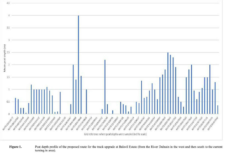
That includes the section within the CNPA boundary beyond the Raitts bothy and it was because of concerns about the peat there that the CNPA initially proposed the road should take a higher line across Meall a Chocaire (which would have made the track highly visible from the central Cairngorms). CNPA staff in commenting on the application (see here) expressed concern about the lack of detail of how the Balavil Estate proposed to construct a road across this peatland but started from the assumption that the estate needed a road rather than considering alternatives, including whether it would be better to use existing roads on neighbouring estates.
The fundamental issue is long sections of the new road would need to be “floated” over the peat:

What this means is that terram matting is placed on the peat and then covered with a layer of aggregate to create a new “hard” road suitable for vehicles. This will introduce new materials which are alien to peatland and change the drainage, through water flowing off the track, ditches and culverts. The Planning Application claims that the aggregate necessary can be sourced from three borrow pits located in higher dryer ground and which are just 10m in diameter. This does not stack up and far more material than this appears to be needed.
The approach of our Planning Authorities is usually to assume that if the right techiques are used, roads can be installed anywhere. If the CNPA demanded a proper plan in this case, the huge impact of constructing this track through peatland would become clear and add to the argument that it would be far better for Balavil to use neighbouring estate roads.
History
My thanks to the historian David Taylor for providing information on the old Drove Road crossing the Monadliath. This went from Loch Gynack, above Kingussie, up onto the summit of Beinn Bhreac and then joined the line of the proposed route over towards Carn Dulnain and down to the River Dulnain “betwixt Corrycglaginmore and Corrychlaginbeg” or to the end point of the new road. Drove Roads of course were not roads in the modern sense but routes walked by cattle and their drovers. In many places, as here, they have left no trace. That history seems to me another very good reason why neither the estate nor the National Park should have ever considered a road here.
What needs to happen
Balavil’s proposed new road will damage wild land, landscape and peatland (and will almost inevitably lead to a further application for an extension west of the Dulnain – indeed one of the Planning Documents is described as “Phase 1”). Whether or not roads are justified for management purposes – and no convincing conservation reason has been produced for this road whose main purpose appears to be to intensify grouse moor management with all that implies – there is no need for Balavil to construct a new hill road when there is such an extensive network of roads in the area. Whatever the arguments of the estate, the new road is not necessary. What is necessary is that the CNPA helps ensure Balavil and neighbouring estates co-operate. (This is not just about Balavil using the Pitmain and Dunachtor roads but about those estates being able to use the existing Balavil Rd).
The CNPA Board could give a lead to staff here. Its clear from staff’s comments on the Planning Papers that they are concerned both about the damage that has been caused by ATVs and the lack of details for the proposed new road. However, they have all commented without considering the wider context, both the importance of Wild Land and the extent to the existing road network into the Wild Land Area. The CNPA need to empower staff to start taking a wider perspective, which looks at land use and management as a whole, rather than commenting on developments from a narrow planning focus which sees each development in isolation.
That will be far more likely to happen if significant numbers of people and organsations object to Planning Applications such as this and call on the CNPA to implement its policy presumption against new hill roads in cases such as this. Please consider doing so here.
Interesting. Drop me a line if you want some spatial impact analyses done viz effects on remoteness and visual impacts on wild land quality and potential reduction in WLA extent.
Steve, that would be wonderful – the CNPA should be asking you for this! – I’ll email you, Nick