Objection to Planning Application 2017/0254/MIN Development of a Gold Mine, Glen Cononish, Tyndrum
[Editor’s note: Bill Stephens submitted this objection to the current Cononish gold mine planning application on 5th December. While the documentation on the Loch Lomond and Trossachs National Park planning portal (see here) has been added to since then, Bill’s objection contains a fine analysis of the issues for all those concerned about landscape and wild land in the National Park. Since he submitted it Scotgold has responded to objections from myself and Mountaineering Scotland (see here), prior to the special Board Meeting which is scheduled to determine the application on 29th January, and I will consider that response and other matters relating to the application then].
Introduction
The planning application is presented as a further revision of the planning consent granted in 2015, reference 2014/0285/DET, with the accompanying Environmental Statement suggesting that what is now proposed is more environmentally acceptable but the driver is clearly to reduce costs. The main differences are:
- changes to the ore processing building and associated screening;
- disposal of all the tailings on the surface in ten ‘stacks’ instead of partly underground and in a ‘cross valley impoundment’;
- construction of more than 2 km of surface water interception ditches around the stack areas instead of the diversion of the Alt Eas Anie to the south of the impoundment; and
- extending the duration of the mine from 10 to 17 years with the potential to further extend this.
This submission considers each of these changes in turn before highlighting the implications for the Loch Lomond and Trossachs National Park and the Ben Lui Wild Land Area. These mean that the National Park Authority must refuse planning permission for what is now proposed as well as not renew the consent for the approved scheme and should focus efforts on restoring the existing site.
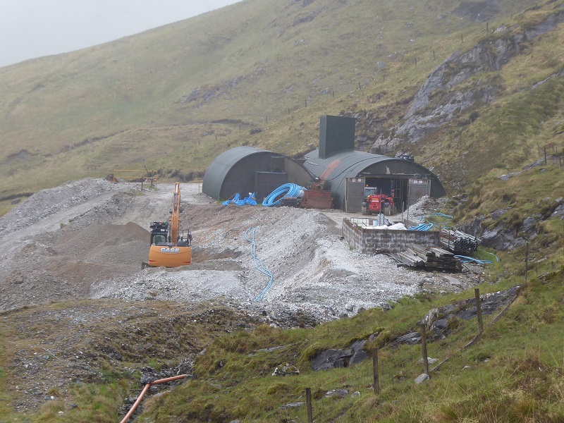
Ore Processing Building
The building now proposed is 80 metres by 30 metres, nearly 50% bigger than the average Aldi store, and has a 6% larger footprint than that approved in 2015. The design is also more monolithic in appearance with reduced screen bunding and consequently will be an even more prominent feature in the landscape.
Tailings Management
The approved scheme is to deposit 147,000 tonnes of the ore processing tailings within the underground workings with the remaining 400,000 tonnes pumped as slurry to an ‘impoundment’ contained by an embankment constructed with some waste rock from the mine and excavated from the Alt Eas Anie diversion together with glacial till excavated from the impounded area.
It is now intended to reduce the water content of the tailings to a ‘damp sand’ and transport all the now estimated 530,000 tonnes by 25 tonne all-terrain dump truck to one of ten stacking areas. There will be a need to construct a haul road from the ore processing site to the stacks and a crossing of the Alt Eas Anie to stacks 3 to 6 but details do not appear to have been submitted with the planning application. The stacks will have a basal layer constructed using some 172,000 tonnes of waste rock excavated from the mine with the total amount of waste material to be disposed of in the stacks some 50% more than on the surface for the approved scheme.
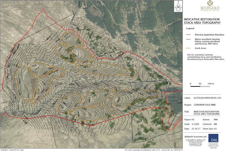
The footprint of the stacks range in size from 5,425 square metres to 15,498 square metres, larger than the outer perimeter of an athletics track, and in total cover an area twice that of the currently approved tailings management facility. The tailings are to be placed on a foundation of waste rock excavated from the mine and compacted in 300mm layers to the desired stack landform. The particle size distribution of the tailings indicates that 80% is finer than 125 microns and is more accurately described as a silty fine sand with engineering properties unsuitable for what is proposed.
Although laboratory analysis of samples from the existing waste heap at the mine and a single ‘representative’ tailings sample provided by Scotgold suggest that the material is ‘inert’ with acceptable acid rock drainage characteristics, it appears that the suitability of the material as a growing medium has not been assessed either for this planning application nor indeed for the approved scheme.
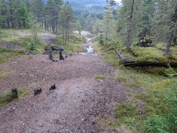
The gold is to be mined from the Cononish Vein which had several lead mines along it in the past with the ore including galena (lead sulphide) and the spoil having elevated concentrations. The ore could therefore be similar to that mined from the Tyndrum Main Vein with the previous activity on the slopes of Sron nan Colan leaving large spoil heaps still unvegetated 100 years or so after mining ceased. This is typical of other lead mining areas where the difficulties of establishing vegetation on spoil heaps are well known.
It is intended that the final landform for each of the stacks will replicate the hummocky glacial terrain that is there now but it seems that these will be modelled on larger drumlin features and will look quite different. It is also the intention that final restoration of the stacks will attempt to recreate the existing vegetation type in a few years that has taken 10,000 years or so to establish here.
The potential plant toxicity of the tailings combined with their engineering properties, the altitude of the site and its exposed location makes it extremely unlikely that the restoration aims set out in the Environmental Statement will be achieved. The cost of restoring the site to anything like what was there before mining operations commenced will cost many £ millions, much higher than the financial guarantees provided by the approved scheme legal agreement. It is also evident that these guarantees are inadequate for the remediation of the approved scheme.
Surface Water Drainage
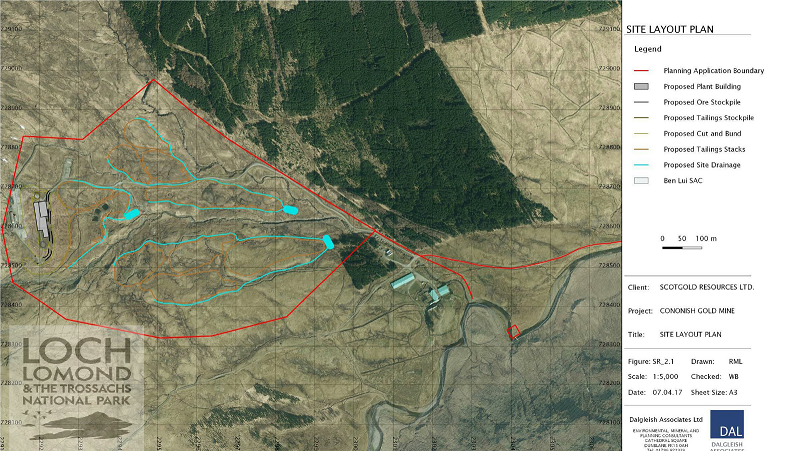
The construction of the tailings management facility for the approved scheme requires the diversion of Alt Eas Anie with a channel to intercept its tributaries to the north and one of the stated benefits of what is now proposed is that these will no longer be required. However, because of the need to keep to a minimum surface water runoff entering the tailings stacks and avoid downstream watercourse pollution, over 2 kilometres of peripheral open drains will be required. These will have a man-made appearance and add to the difficulties of achieving the restoration aims.
Duration
The existing permission for the mine is for ten years but the planning application is now for 17 years to allow for a reduced rate of ore extraction and processing. Going further into the Cononish Vein and extracting more ore has previously been identified as a possibility and Scotgold have also highlighted six other priority targets within a 2.5 km radius of the Cononish Mine. These have the potential to extend the life of the operation well beyond the 17 years that planning permission is being sought for.
Planning permission for exploratory works to enlarge the existing adit and create a waste rock spoil heap was originally granted in 1988 and extended in 1989 with a scheme for the mine approved in 1996. An amended scheme for the mine was granted consent in 2011 with an extension of time, that also included 24 hours working, approved in 2015. A nine-month bulk processing trial to extract gold from part of the existing spoil heap was given planning permission in April 2016 and approval was subsequently given to increase the amount of material to be processed as well as extend the duration of the trial to the end of March 2018.
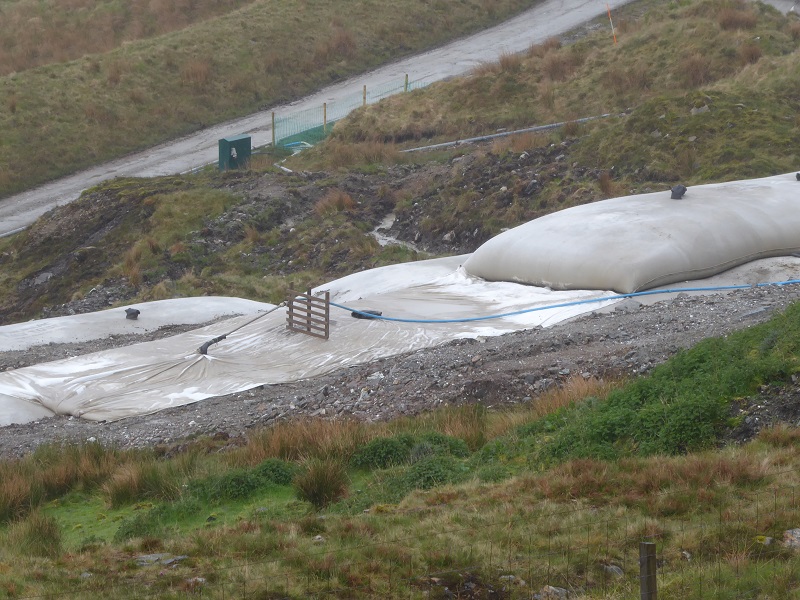
The tailings from the processing trial are being contained in long geotextile bags which are much more intrusive than the spoil heaps. The planning permission stipulates that the bags can remain until May 2021 when the site ‘shall be restored and remediated…unless there is an extant planning permission for the development of a mine at the site’. How this has been allowed to continue in what is supposed to be a protected landscape for some thirty years with the prospect of another twenty years, should the current planning application be approved, and applications for further extensions to the size and duration of the mine likely, is difficult to comprehend.
National Park Aims and Landscape Special Qualities
The currently approved mining scheme was assessed in relation to National Park aims in the report on the planning application that was considered by a Special Board Meeting of the National Park Authority in October 2011. These aims are:
- to conserve and enhance the natural and cultural heritage of the area;
- to promote the sustainable use of natural resources of the area;
- to promote the understanding and enjoyment (including enjoyment in the form of recreation) of the special qualities of the area by the public; and
- to promote the sustainable economic and social development of the area’s communities.
The Sandford Principle gives precedence to the first of these.
The report concluded that because of ‘the impacts on landscape and scenic qualities, wild and remote character and the associated recreation experience of walking and climbing in the surrounding area’, mining here would be contrary to the first and third of the aims. ‘However, as these losses and impacts would not be permanent and the special qualities and recreation experience could be recovered and moderately improved within a 10 to 15 year period the proposals could be argued to support these aims… the impacts and benefits associated with this development will, taken as a whole, have a favourable contribution to the National Park aims’!
Even more remarkably, it goes on to suggest that because ‘the impacts on natural heritage interests are temporary and will be ultimately conserved and enhanced in the long term’ the proposal is considered to contribute to the first aim. Consequently, there was considered to be no need to invoke the Sandford Principle and the planning application for the mine was recommended for approval. This was accepted by the Board with the National Park Authority Convener subsequently stating that ‘the glen will regain its quiet, remote character following closure of the mine and the landscape will be improved from its current state’.
The 2010 report on the Special Landscape Qualities of the National Park provides a baseline for the ‘celebration, promotion and safeguarding’ of the National Park. The report describes the special qualities of each area of the Park including ‘Wide Strath Fillan’ where reference is made to the Tyndrum mines ‘highly visible on the slopes of Sron nan Colan, stand out barren within the surrounding woodland, and are witness to the economic activity of the past’. It goes on to mention the glimpses of Ben Lui with the flat-bottomed Glen Cononish leading into the heart of the high mountains past the ancient Caledonian pinewood of Coille Coire Chuilc but no mention is made of the recent mining activity on the eastern slope of Beinn Chuirn, presumably because it was at that time still a relatively small-scale operation.
Ben Lui Wild Land Area
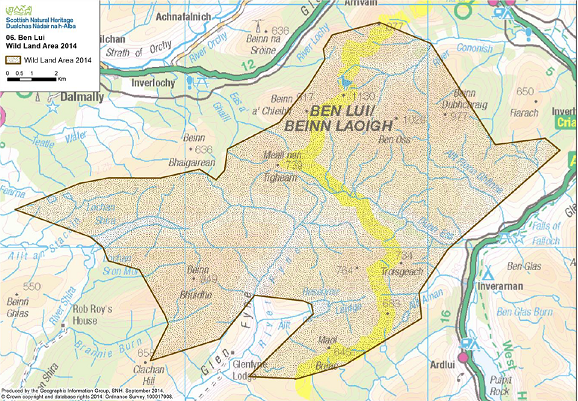 The Ben Lui Wild Land Area was designated in 2014 and most of the proposed mining operations lie within this. Although the protection of Wild Land Areas from development is currently advisory not mandatory, it is still a material planning consideration and the Environmental Statement provides a Wild Land Assessment.
The Wild Land Area description recently published by SNH mentions Ben Lui being regarded as the ‘Queen of Scottish Mountains’ and, quoting from the 2010 Special Landscape Qualities report, refers to the ‘great tract of hills and mountains rising steeply and dramatically from the glen floors…the bare upper hillsides and mountains appear untouched, remote and wild, rising above the long glens where farming, forestry and infrastructure are found’. It goes on to highlight the affect that development has on emphasising the relatively small extent and sense of remoteness and sanctuary of the eastern part of the Wild Land Area. Mention is also made of the existing mine at Cononish but nevertheless did not exclude this from the designated area again, presumably, because of its relatively small scale.
The Wild Land Assessment contained in the Environmental Statement suggests that the establishment and operation of the mine will have a ’moderate and significant effect on approaching the north-eastern hills’ but this will be medium term and localised to upper Glen Cononish with the effect on the local sense of sanctuary ‘minor and not significant’. The visibility of the mining site from the surrounding mountains and the effect that this will have on their landscape setting including that of the impressive Eas Anie waterfall and ravine is not considered.
The Assessment concludes by stating that the restoration of the site will ‘enhance the naturalness of the existing situation and will be a positive effect in terms of these wild land qualities’. This ignores the fact that what is there now could be restored without having to extend the area of mining operations from less than a hectare to the 40 hectares covered by the planning application and downplays the landscape impact of what is proposed.
What Should Happen Now
The planning application Environmental Statement Overview indicates there is a ‘planning balance’ to be struck between the potential environmental impacts and socio-economic benefits of the proposal and that the findings of the Environmental Impact Assessment demonstrate that ‘there are no planning or environmental considerations which would give rise to reasons for refusal’. The Environmental Statement is of course only part of the EIA process with all consultee responses and other submissions an important part of this.
The short-term impacts on the special qualities of the Loch Lomond and Trossachs National Park and the Ben Lui Wild Land Area of building an ore processing shed the size of a suburban superstore, constructing tailing stacks the size of eight athletics grounds and 24-hour operation of the mine for up to 17 years is too great a price to pay for the anticipated economic benefits and mitigation measures offered. Uncertainties about restoring the land to anything like what it is now in the medium term and, probably, in the longer term, could well leave a huge permanent scar on what is one of Scotland’s most valued landscapes. Consequently, the precautionary principle should apply and planning permission for both what is proposed now and any application to renew consent for the currently approved scheme refused.
It is understood that the mine operator has lodged a financial bond with the Crown Estate, the owner of the mineral rights, that is intended to cover the restoration of the existing mining operations and area affected by the bulk processing trial. The efforts of the National Park Authority should be focussed on ensuring that this work is undertaken as soon as possible and not make things worse by extending the duration or size of the operations.
