“The review process identified six primary sources which estimated the proportion of wildfire that results from managed burning (Table 4), giving a range of 15% to 60%, or 24% to 68% if lowland statistics are excluded. Due to the limited evidence base and caveats acknowledged by the source authors the review team note no basis to offer a degree of confidence in this range. The review concludes that there is evidence that muirburn directly causes a proportion of wildfires that occur, however there remains uncertainty regarding this proportion.”
That is a very wide range and clearly the data on causes of wildfires is not good enough but even the lowest estimates were that a quarter (24%) of upland wildfires are caused by muirburn. Recent research from the James Hutton Institute, an organisation which I normally respect and has done great work on Scotland’s soils, is therefore very surprising (see here). It claims that:
“Overall, 96 % of the total wildfire area occurred outside moorlands managed by muirburn, with wildfires covering 1.1 % of total moorland area.”
This figure is now being used by grouse moor interests, like the Heather Trust today (see here), to justify muirburn on grouse moors, claiming not only that it is a negligible cause of wildfires but also that it actually helps prevent wildfire.
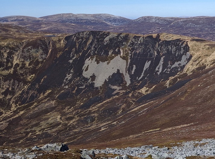
It is important to note here that the James Hutton research does not report the number of wildfires recorded on moorland managed by muirburn, only on the area affected and that the research methodology they used suggested this was very small. This raises some important methodological questions about the extent to which the aerial survey methods used would pick up on relatively small wildfires and how the researchers determined when muirburn had got out of control and should be recorded as a wildfire. The recent damaging wildfire caused by muirburn west of the Cairnwell, which took place on a steep slope and would be hard to detect from satellite images, provides an example:
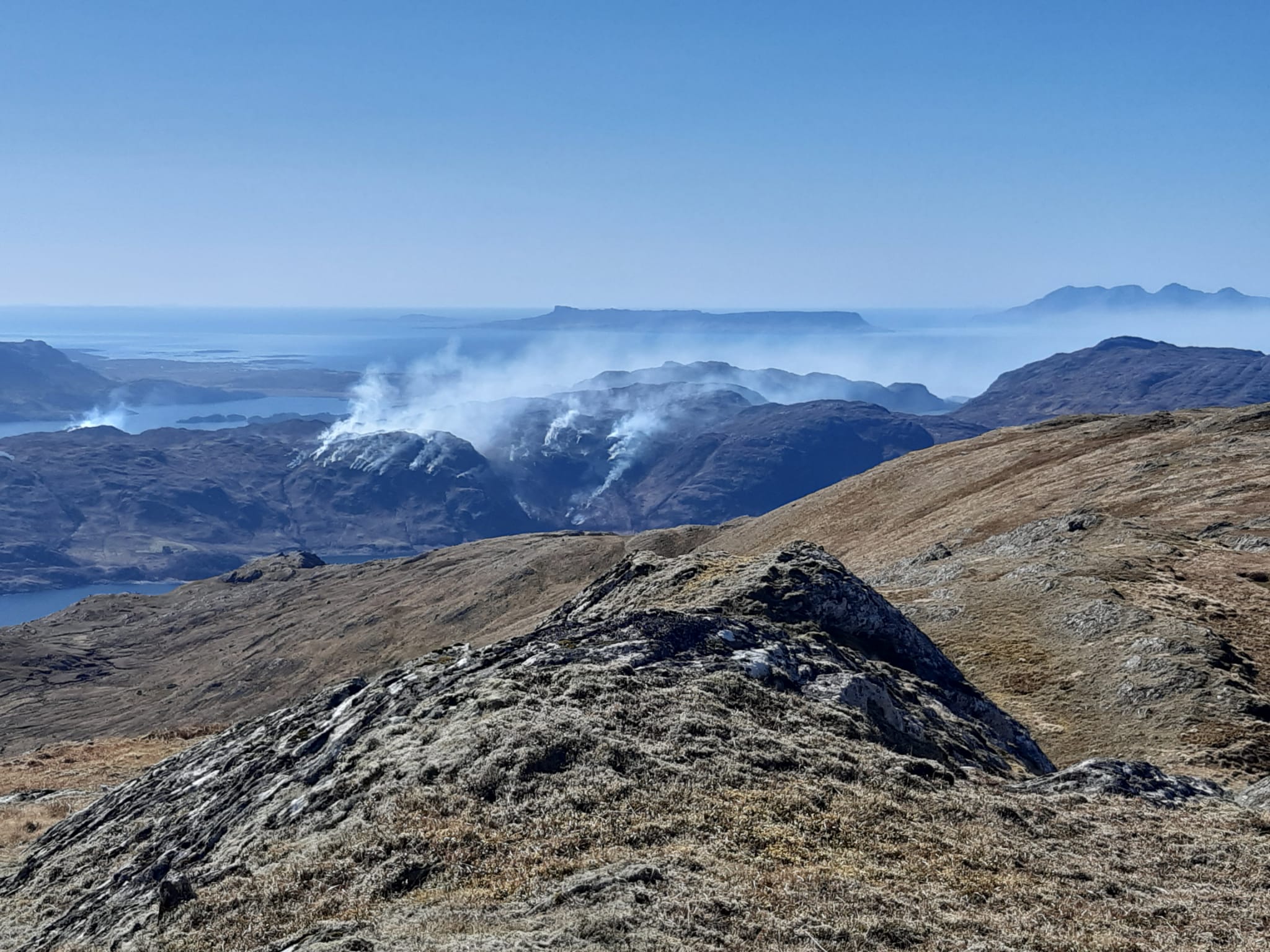
There are reasons, therefore, to be sceptical about the headline conclusion from the research as well as the fact that it involved the Game and Wildlife Conservation Trust – a front for sporting estates – and was funded by the Scottish Government (as part of the 2022–2027 Strategic Research Programme (JHI-D4-4, JHI-C3-1, JHI-D5-2), previous Strategic Research Programmes (2016–22), Underpinning National Capacity and Contract Research Funded projects – Grouse Phase 1 and Phase 2 (see here)). However, its “finding” that wildfire affects a far far greater area of land outside of grouse moors managed by muirburn should not come as any surprise and is undoubtably correct. The wildfires in the west of Scotland in the recent very dry period, some caused by muirburn and some not, were far more extensive than any caused by intensive grouse moor management. The photos above illustrate the differences.
As the research puts it:
“Heather grasslands, peatbogs and habitats on peat soils had a greater proportional area of wildfires than other moorland habitats and habitats on non-peat soils. In contrast, heather heathlands with non-peat soils had a greater proportional area of muirburn”.
The important point here in my view is the amount of vegetation in Scotland, however described, that is going up in smoke and the impact this has on nature and carbon emissions. This is being caused by “controlled” muirburn and wildfires, a significant proportion of which are caused by muirburn getting out of control. The report does not provide any data on the extent of the destruction but does reveal its bias in its explanation for the relatively low proportion of grouse moors affected by wildfire:
“We suggest the limited co-occurrence of muirburn [this should have said muirburn on intensively managed grouse moors to distinguish it from muirburn intended to improve grazing] and wildfires, may be due to fuel load reduction following muirburns, but may arise due to wildfire prevention strategies on estates and/or lower occurrence of recreational caused wildfires. In addition to muirburn regulation, our findings emphasise the need for policy, management, awareness and education outside of muirburn areas to reduce the risk of wildfires.”
Extraordinarily the James Hutton research does not include any reference to the data provided by the Scottish Fire and Rescue Service to the Cairngorms National Park Authority for their consultation on the introduction of byelaws to ban campfires (see here):

This data shows that muirburn on grouse moors in the Cairngorms is NOT as benign as implied by James Hutton’s headline finding, being responsible for c19% of all out of control fires. This undermines their proposition that the relatively low proportion of land of land on grouse moors destroyed by wildfire is as a result of grouse moor owners’ “fire prevention strategies”. The truth is the purpose of muirburn on grouse moors never has been to prevent fires, its been to produce more grouse to shoot and to suggest otherwise is highly misleading. If grouse moor owners cared a jot about wildfire, all muirburn would have ceased as soon as the SFRS had issued its warnings of high fire risk and on windy days but, following King Charles’ appalling example (see here), they have carried on regardless.
The SFRS data also shows that the researchers’ apparent assumption that outdoor recreation is a primary cause of wildfires in areas outside intensively managed grouse moors is questionable. Yes, 13% with the Cairngorms National Park is significant but it is far from being one of the main causes of wildfire and less important than muirburn. Where the researchers are probably right, however, is in stating that outdoor recreation plays a very small role in causing wildfires in areas intensively managed as grouse moors. The reasons for this should be obvious, intensively managed grouse moors are not great places for camping or barbecues, but stating it further exposes the lack of any justification for the Cairngorms National Park Authority’s introduce a blanket ban on recreational fires across the National Park (see here).
Where the James Hutton researchers are in my view correct, however, is in their claim that the relatively limited extent of wildfires on grouse moors is because of “fuel load reduction”. Another way of putting that would be to have said that as the land on grouse moors is regularly burnt to bits there is very little left to burn. The challenge facing conservationists is that grouse moor interests are now using this fact, made respectable by the James Hutton researchers, to present muirburn as a means of preventing wildfire when in act it is a disaster for carbon emissions, destructive of nature and a health hazard for humans.
In the last year or so grouse moor interests have had considerable success in getting our public authorities to present muirburn is part of the solution to wildfires, rather than a significant cause and a problem in its own right. The Wildfire Conference 2024, organised by the Heather Trust, was full of presentations (see here) advocating burning as a solution to wildfire risk and climate change rather than “nature based solutions”. Hence too why NatureScot is proposing to water down the Moorland Code, as I have described in recent posts, and hence too why the Cairngorms National Park Authority’s draft Integrated Fire Management Plan (see here) – the public consultation on which ends this week -proposes to give those responsible for destroying the National Park through muirburn the key role in tackling wildfires in the National Park!
The power and influence of grouse moor interests over those in authority appears to be growing unchecked. Its time to revive Revive, the Coalition for Grouse Moor Reform and to create a much broader coalition to ban muirburn completely.
Note
Please keep those photos of wildfires caused by muirburn coming. I intend to write soon about the impact that muirburn has on peatland formation and carbon emissions.

Very interested in this – I am chair of Bute Community Forest and we just lost 8ha of SSSI from a fire from the neighbouring estate – see our Bute community forest facebook for graphic images…
Hi Richard, thanks for getting in touch and this is very interesting (if tragic). The revised version of the Muirburn Code out for consultation states You must not…………………undertake burning which leads to deforestation (and also that you should not burn on SSSIs unless that is part of the plan for the SSSI. Unfortunately, it fails to say what should happen if burning in these places occur when at the very least one might have thought the muirburn license would be removed. That confirmation from NatureScot would then make it much easier for neighbouring landowners to claim compensation for the damage. If you have not done so, I recommend you report the damage to NatureScot and ask what they are going to do about it.
Oh god, that’s sad. I just back from the Ardnamurchan peninsula, where I witnessed the wildfires first hand. The speed with which it spread was shocking. I’m too sad for those creatures unable to outrun the flames.
The fire Anna may have witnessed so nearly had serious consequences for those who live on the west side of Acharacle village. It might have reached into woodlands above Salen. It began very small on a hot sunny afternoon near a fishing loch over 1.5 miles away from there. (Possibly focus of light by a discarded bottle ignited it?)
On the second day Volunteer fire crews worked urgently to “steer” the advancing line of fire away from the local water catchment header plant. But flames continued to spread up hillsides as the wind shifted to the east over night.
Later on that 2nd day the hard pressed crews were reinforced by crews from Mallaig Arisaig and further afield. They succeeded in keeping the fire line way from the main water filtration plant building.
By the third day another wind shift had fire sweeping right through ancient natve woodlands to be held back only thanks to efforts by residents and volunteers at the garden ground fencelines within Acharacle village itself.
A BBC report after day 3 mentioned this fire among others across the highlands The report described it as a “grass fire” that extended to some 80 Ha. Probably 10x times that area and much old growth woodland now lies blackened. ( An hour utilising a helicopter with bucket easily refilled from local lochans would have extinguished this fire on day one, and at marginal cost had such technology been made available.)
Even when the James Hutton Institute shows you to be wrong with well conducted, respectable research, and to be fair and to some credit you acknowledge some of what the Institute says but you then go on to try to twist its findings and or use other data to undermine it. The SFRS data for wildfire attendance in the Cairngorms Park is hardly reliable as the 19% figure includes ‘breakdown of type not available’, so most likely nothing to with muirburn on sporting land. In addition to this some muirburn, and some of the worst Muirburn is carried out by sheep farmers burning the fringe areas of moorland. These fires are large (bad for wildlife) and damaging to heather moorland as they are often grazed intensively and thus do not recover as heather moorland, leading to loss of important ecological environment.
You imply that the recent large fires on Knoydart relate to burning for grouse moor management but there isn’t any managed grouse shooting on Knoydart…. the fires can only have been for sheep farming purposes.
Reduced fuel load is really important but more important is a variety of heather ages for all birds and wildlife. Where there is no management you get high fuel load, high wildfire risk. Where you have management (with muirburn) you have fragmented heather age, wildlife, lower fuel load and low fire risk.
Of course there is a correlation between sporting muirburn and grouse shooting as it generates the income to pay for the moorland management, but it has spin offs improving moorland for grazing (again income generating) with lots of small fires to spread grazing and reduce intensity, and for all other birds (less income generating but nevertheless hugely important), and of course creating jobs and livelihoods. Muirburn conducted well is throughly well proven to be the solution to wildfires.
Hi Colin, the fire was NOT on Knoydart – the photo was taken from Knoydart and was of the fire on Morar – but I am fully aware, having spent time in both, that there isn’t any managed grouse shooting in either place. Nick
Lots of posts from “Colin”.
Among his many thoughts ,I note none that appear to acknowledge the historical importance for upland communities of maintaining fire breaks within Scotland’s landscapes. When- post WW2 new forests were established across Scotland proper firebreaks were bulldozed clear of vegetation. Warning signs were also positioned at access points alongside racks of simple fire control equipment.
Local people knew the importance of maintaining such Areas. Managed “back burning” would be necessary to protect buildings and other rural property. The patch burning for shooters seen today all across Scotland’s upland areas, is a different matter, and as I wil set out it is a very modern phenomenon. It has only been given one modernday justification a very weak one, in comparison with creation of vital fire breaks to protect communities from lightning strike fires etc. (? viz: the case around Morar) . Today widespread use of deliberate strip burning for sportshooting across uplands serves to destroy everything there. for no good reason. It is neither necessary or justifiable at all.
As I have remarked before on Nick’s boards. Younger people really do need to study the history of past centuries in far greater depth. Local museum archives exist full of early photos and postcards . A record of how Scotland uplands once appeared: Pristine scenes placed on record in the late 19th and early 20th century. For Centuries prior to that accomplished artists recorded in full colour what they found. Check out the many landscapes within the collections of the National Galleries of Scotland. Many of us may own antique paintings that show this.
This current generation’s belief in the deliberate and willful destruction of so much vegetation across the moors and uplands for spurious “profit” or to “protect” jobs of estate workers, – when international travel and hospitality creates far more local employment today – is not part of visual record left by those landscape artists of a bygone age.
The damage to moors and uplands is permitted by lax application of environmental regulation, right now, across the uplands. Today online in the 21st century we can see this from Space. Satellites can as easily be used to pinpoint precisely when – and on whose ground – large fires start? The ‘blame trail’ to ‘finger’ those responsible in every case could be followed?
One Final point: In the National Library of Scotland there is a recently opened archive of aerial mapping carried out by RAF and USAAF reconnaissance teams across Scotland during and after WW2 . This archive easily serves as a base line for historians to show all post WW2 development. This a B/W photographic record for all time. Clear evidence as to the situation before strip burning for shooting became so commonplace . The archive does not mislead. Impossible to deny? https://maps.nls.uk/os/air-photos/info.html
If you ask GenAI about the history of rotational heather burning this is what you get:
Rotational heather burning, as a deliberate and managed practice, has been used for roughly the last 200 years, primarily in the context of grouse moor management. While burning has been used in the uplands for much longer (potentially since Neolithic times), the current form of rotational burning, with specific aims for grouse habitat, became more codified in the 19th century.
Here’s a more detailed breakdown:
Historical Use:
Burning has a long history in the UK uplands, potentially dating back to Neolithic times for land clearing.
Medieval Period:
Burning or “swaling” was used on Exmoor in the 1300s to improve pasture, and the term “muirburn” appears in Scottish law in 1400.
Grouse Moor Management:
The practice of rotational burning, specifically for grouse habitat management, gained prominence in the 19th century and became more standardized after an inquiry into grouse disease in 1911.
Modern Practice:
The current form of rotational burning, with specific patterns and timings, has been used for approximately the last 200 years.
Whilst I acknowledge it hasn’t been done for ever it has been an accepted management technique for a very long time and has well documented benefits. You can’t pick a period in history and say lets all aim for what it was like in the Bronze Age because guess what there weren’t tourists in the Bronze Age or people using the hills for recreation. Rotational heather burning is one of many environmental management techniques that mankind uses and it has been evolved in to one of the better ones which yes serves economic and sporting interests but also which serves wildlife well. Where it is banned or has stopped we see wildfire, deep peat and considerable habitat and ecological damage. And I’m really not sure Tom that bulldozing roads across tracts of the highlands for monoculture sitka spruce plantations, you refer to, is a more effective management technique – in fact probably one of the most destructive phase in history in the highlands, leading to peatland run off, loss wildlife, excessive deer populations and so much more (and still going on).
Nick is right to point out the real issue here is not whether the fires are wild or ‘managed’, but rather what is the total area burned annually by sector?. Fires, wild or ‘managed’ release carbon, pollute the air and destroy habitats and biodiversity. Some ecosystems have evolved to become reliant on fire (such as lodgepole pine in its native land), but this is not the case in Scotland where lightening strikes are far less frequent than other places. Fire is used by sporting estates to bump up the number of birds they can shoot come August, but can never be described as part of nature’s cycle, far from it. The Hutton research seems to have been conceived to support the sporting estate narrative that grouse moors prevent ‘wild fires’, but what I would like to know is which sector burns the most land and thereby harms nature, emits carbon etc. Is there an analysis out there that tells us how many hectares of land are burned in total annually (‘deliberate’ and ‘wild’) by sector e.g. by sporting estates, by sheep farms, by tourism etc. Wild fires are of course unpredictable and hence pose a risk to property but that is a slightly secondary issue to the total extend of burning.