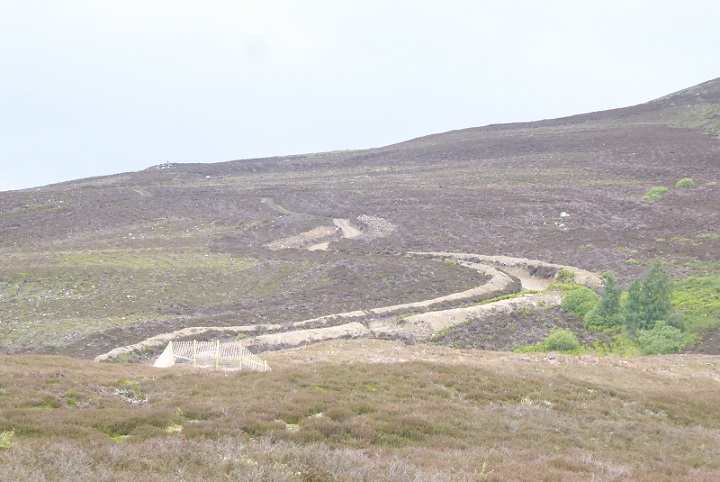
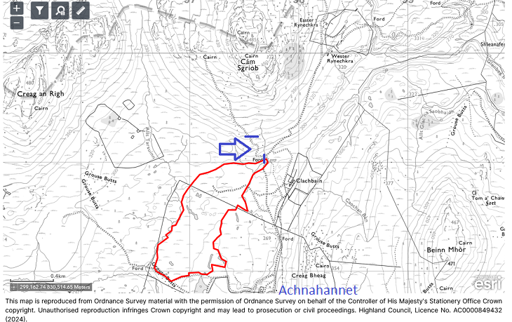
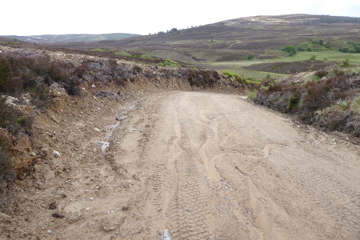
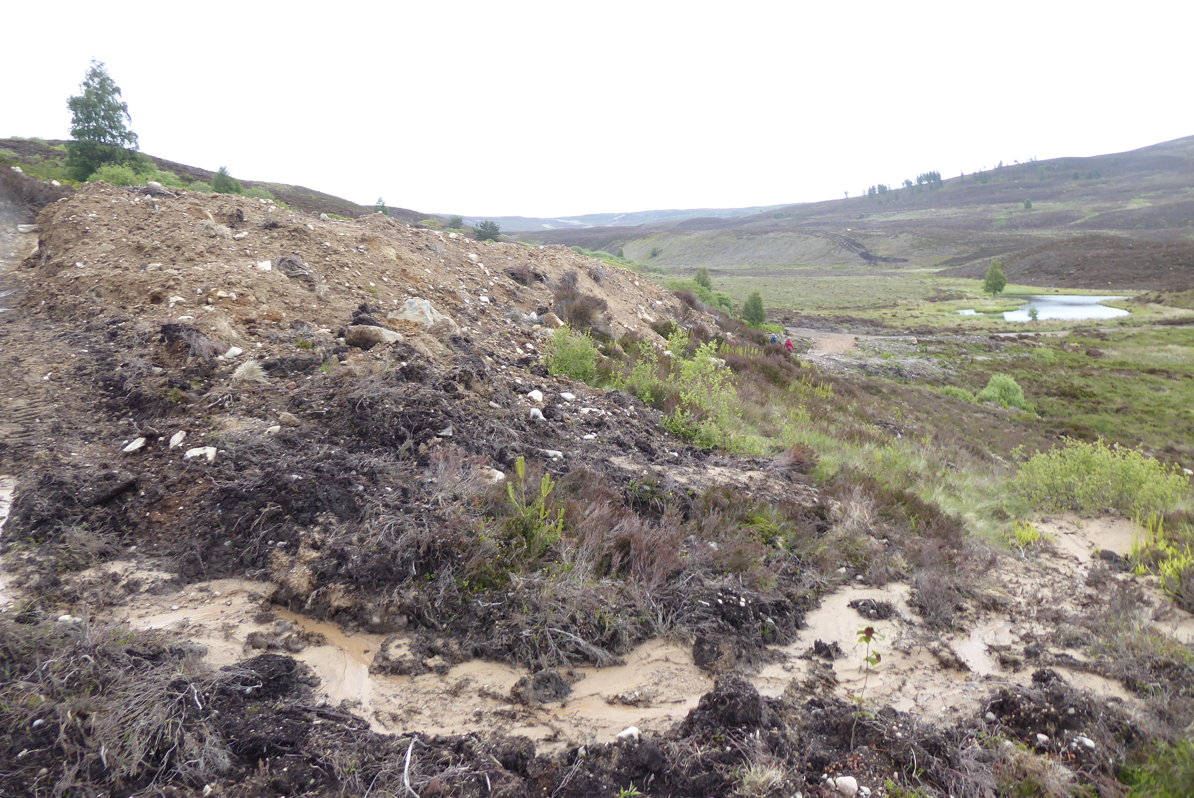
A few weeks ago I was alerted by a Parkswatch reader to an excellent post on facebook (see here) about the Muckrach’s new forest, which the estate describes as one the largest “landscape scale projects” in the UK (see here). On my way up north 10 days ago I decided to go and have a look with friends. We drove up the minor road, off the A839 between Carrbridge and Grantown, to Achnahannet, near to the heart of the estate. We were greeted with the sight of this bulldozed road, the most monstrous example I have seen for some time.
The Muckrach Estate website claims its (carbon off-setting) project was “developed in conjunction” with a host of public authorities including Scottish Forestry, the Cairngorms National Park Authority (CNPA), NatureScot, the Scottish Environment Protection Agency, Historic Environment Scotland and Highland Council “to ensure that it delivers the best possible outcomes for the community, wildlife and landscape at Muckrach”. For Scotland’s sake!
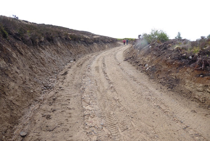
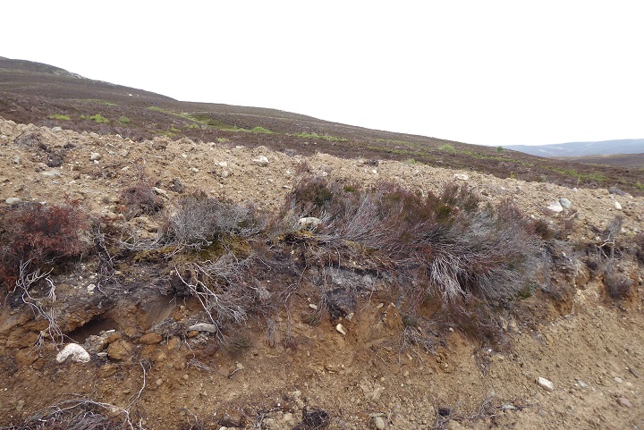
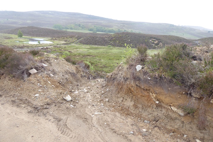
Close up, the new “bulldozed” section of road was a bad as it looked from a distance, a huge trench – over head high in places – excavated up the hillside.
While “upgrades” to forestry roads still do not require full planning permission, they do require to be notified to the local planning authority for comment. I can find nothing on either the Highland Council or CNPA planning portals to indicate any Prior Notification was submitted for this road. It is possible, therefore that neither planning authority are aware of the monstrosity. If so, the “forest road” would lose its permitted development status and that would enable either planning authority to take enforcement action and require Muckrach to restore the road to its former state.
The design of the new section of road appears quite deliberate, raising questions of who was responsible for this and who knew about it? There is Woodland Design map on the Muckrach Project website, which was produced by Savills (see here), but this does not show any proposals to create new roads. It may be that the application for a Scottish Forestry grant, which appears to have been developed by Savills, included proposals to upgrade this road. In that case both Scottish Forestry and the CNPA should have been fully aware of it and the question is why did they not object? If the road was omitted from the Scottish Forestry grant application, they should now be able to withdraw the grant paid to Muckrach for breaching conditions (I have submitted a Freedom of Information request to Scottish Forestry for all information relating to the contract).
Whether our public authorities were aware of this road upgrade or not, this landscape disaster would have been avoidable had the CNPA or Scottish Forestry or any of the other public authorities made it clear to Muckrach and their agents the importance they placed on upholding the rules which are supposed to protect landscape and nature. Part of the problem is landowners, consultants and contractors cashing in on carbon restoration projects know they can ignore the rules with impunity, as evidenced by the failure of the CNPA to prevent AKRE trees and ABRDN carrying on with unlawful “road improvement” works at Far Ralia (see here).
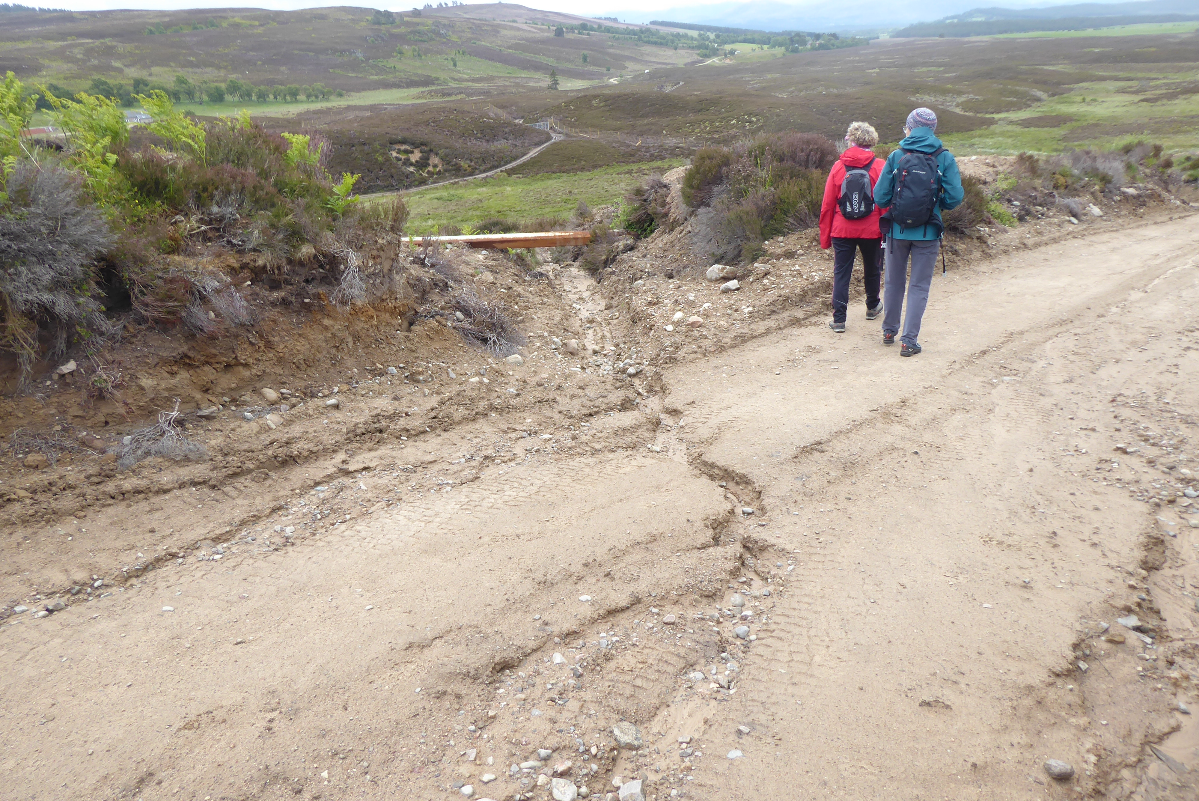
The CNPA and Scottish Forestry are both heavily involved in the Muckrach carbon offsetting project. Even if not informed about the road, staff from both organisations should have visited the site to monitor the quality of the tree planting work (Scottish Forestry) and the quality of the peatbog restoration (the CNPA). That starts less than 100m beyond the drainage channel in the photo above. Neither organisation therefore should have any excuse for not knowing about this monstrosity and not acting.
Unfortunately, Scottish Government targets provide a disincentive to Public Authorities addicted to “performance” culture to enforce the rules. Both the CNPA and Scottish Forestry failed to meet their tree planting targets last year. Doing anything that would oblige land-owning interests and developers to keep to the rules and prevent them taking short-cuts (and making more money out of the public grants system) would risk even fewer co-operating and more missed targets. The whole voluntary approach, founded on trying to influence landowner behaviour by offering financial incentives to meet targets, is fundamentally flawed.
But perhaps the CNPA and Scottish Forestry and trying to negotiate with the Muckrach Estate and Savills behind the scenes to persuade them to restore this monstrosity? After all, according to the CNPA’s homepage (see here) “this unique and special place needs caring for………….”
If so, the contrast between how the CNPA deals with law-breaking landowners, in secret, and the general public, as evidenced by the birdwatching show trial last year (see here), is striking. The evidence points to the CNPA being far more interested in telling individual members of the public what to do than in protecting the landscape of the National Park from the ravages of development:

To put matters in perspective, it would have taken thousands of walkers walking up the old track at Muckrach for decades to have caused this amount of damage to the landscape. From a recreational viewpoint, there are far too many areas of the National Park where walkers or those interested in wildlife (like Calum Campbell who wrote the facebook post) rarely go. As a consequence, in many places there is no-one to complain when the National Park betrays the ideals for which it was created.
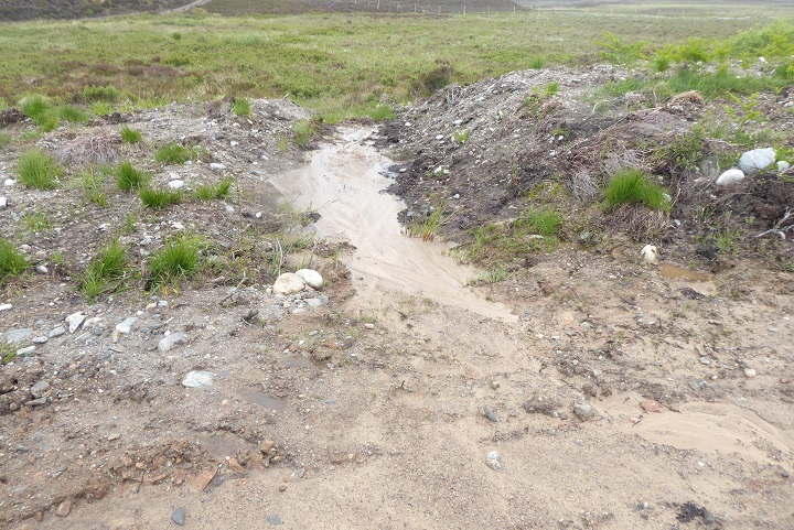
Whatever may be happening behind the scenes, the CNPA should be treating the rich and powerful according to the same principles which it applies to the public. The four statutory aims of our National Parks, conservation, public enjoyment, sustainable development and wise use of resources should apply to all. Rroads like this breach all four of our National Parks aims: they represent landscape destruction, not conservation; they wreck public enjoyment of what should be special places; they are not sustainable (the road will have washed out in a year or too); and they certainly don’t represent wise use of resources.
The fact that a monstrosity like this road can happen 20 years after Scotland’s two National Parks were created tells you something about their failure to make a difference and why they need to be reformed.
There is an excellent article on this in the Spring/Summer issue of the Cairngorms Campaigner, the newsletter of the Cairngorm Campaign (see here), which quotes Grant Moir, Chief Executive of the CNPA, calling for the effectiveness of Scotland’s current National Parks to be judged on “facts and evidence rather than hearsay and antidote”. I would suggest to Mr Moir and his board that the facts and evidence from two further major carbon offsetting projects on Speyside – ABRDN’s Far Ralia and BrewDog’s Dead Forest at Kinrara – are completely damning. Both have involved large emissions of carbon, through tree planting on peat, and significant damage to the natural environment at public expense.
Muckrach’s Forest, as I will show in a further post, is no better.
Having read the Planning Application for this woodland creation , Savills who are the agents dealing with this for the Muckrach Estate, the question was asked “ will hill tracks be made on this woodland site and if so will the tracks be reinstated when all work is finished “ Savills reply was “ no hill tracks will be made”.
Unfortunately, it seems nobody is accountable after permission is granted for these schemes
Thank you very much for this Calum, I am still awaiting a copy of the woodland creation plan from Scottish Forestry but you are dead right, no public authority takes responsibility for enforcing plans
I suppose the Romans and Thomas Telford had to ask
Permission to build their monstrous roads in Scotland. This is much ado about nothing.
Thomas Telford was directly accountable to the Parliamentary Commissioners for Roads and Bridges and had to justify his every project to Westminster. Perhaps that helps explain why his roads have lasted over 200 years, probably 20 times longer than tracks such as the one featured in this post?
Just incidental to the remark by Malcolm …(Had Thomas Telford got his proposal through parliamentary consents with necessary grant funding , I understand, the main military road from Stirling towards Skye would have headed north-west passing near Tyndrum, to Glenelg.. across Rannoch Moor, past Spean bridge and then up Glen Arkaig and Glen Dessary to somehow cross the col to reach Loch Hourn near Barrisdale. Near there, eventually a military bridge was intended to lead on along the sheer slopes towards Glenelg. Far-seeing as it was for that ‘wilderness’ time, that shorter drove-route should have connected up Scotland so much better. Too costly …His ambitious idea foundered.)