Climate complacency?
Today, as I write this, the Scottish Parliament has been debating what the media tend to refer to as the Climate Change Bill. Its not. The Bill contains not a single measure which will tackle carbon emissions or mitigate the impacts of global warming. Instead, its all about setting targets, as its full title “The Climate Change (Emissions Reductions Targets) (Scotland) Bill” suggests. At the centre of debate today is the question of whether Scotland should aim for zero net emissions by 2045 or bring the target forward to 2030 and act like there really is an emergency. The result will be known by the time you read this.
While the Stop Climate Chaos Coalition has rightly been lobbying to strengthen the bill (see here), targets in themselves won’t change anything. A timely illustration of this was the decision earlier this week by Roseanna Cunningham, the Environment Minister responsible for the Climate Emissions Bill, to delay the target date for a ban on biodegradable waste being dumped in landfill from 2021 to 2025. For targets to be met, all levels of government need to act and we need serious levels of public investment. Has there ever been a Declaration of an Emergency where so little has happened?
My train-enabled stravaig over the hills from Ardlui to Crianlarich last Saturday (see here) provided lots of evidence about the impacts of climate change and the challenges these pose. I would hope what follows will be a wake up call to both the Loch Lomond and Trossachs National Park Authority and to our politicians.
Rainfall, flooding and Glen Falloch
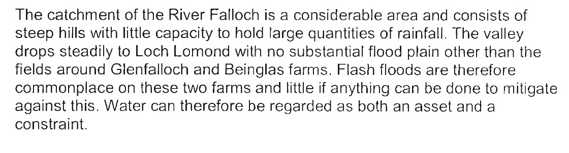
As you travel north up Loch Lomond average annual precipitation increases significantly as it has done for thousands of years. This is a consequence of the prevailing south-westerly air stream and the mountains. The snow that fell in Glen Falloch and the surrounding area accumulated to form the ice which then carved out the glacial trench of Loch Lomond, eventually reaching as far as Strathblane. With global warming, first natural then human induced, there is now little snowfall but much rain. The water drains easily off the steep sided mountains and as a consequence its rivers are what is known as “flashy”, rapidly rising and falling. Flash floods are not uncommon.
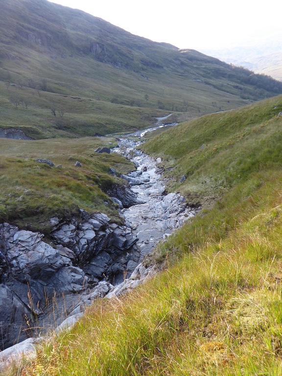
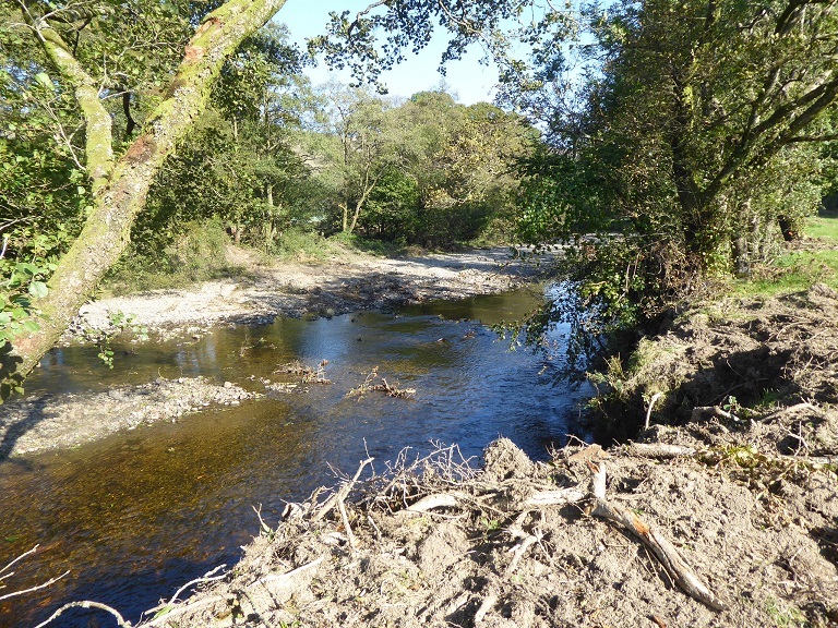
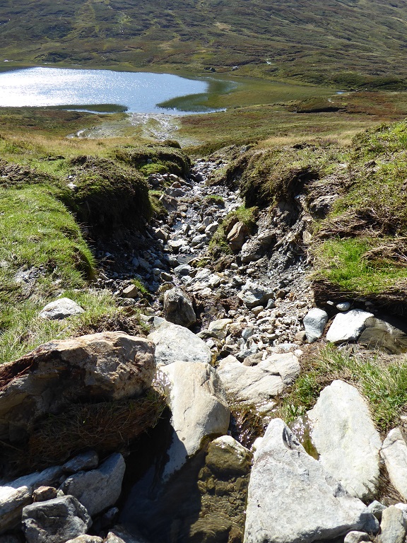
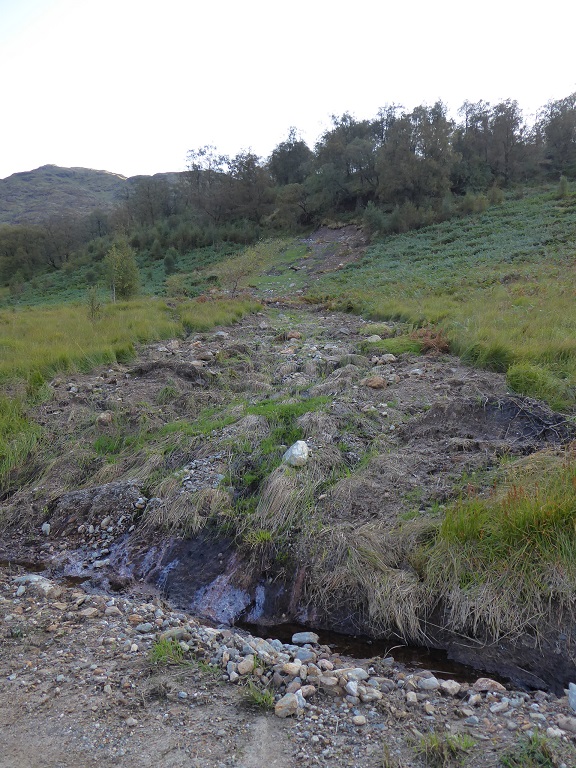
I have been unable to find figures for the amount of rain which washed away part of the West Highland Line on 5th August (see here), but the evidence on the ground suggests it was exceptional, even by Falloch standards.
In the photo above, in the left foreground the flood has stripped vegetation from the rocks. Below, on the right bank from mid-picture onwards, you can see where vegetation has been flattened by the flood. In places, caused by waves perhaps, this is about 6 metres higher than the water levels last Saturday. The bare rock below the vegetation here gives an indication of more normal maximum flood levels. The volume and power of the water would have been incredible to witness.
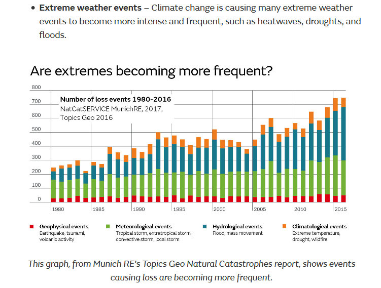
Scientists have been predicting higher rainfall and an increase in extreme events, such as cloudbursts, in Scotland as a consequence of global warming for many years:
What has happened in Glen Falloch, therefore, should have been quite predictable – but has anyone thought about what we might do as a consequence?
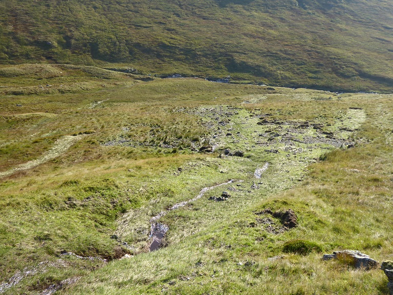
Impact of the rainfall on the floor of Glen Falloch
The standing telegraph poles provide a good illustration that flood plains work and why its so important that we protect them. The power of water reduces dramatically as soon as its allowed to spread out.
Within the normal confines of the river the flood has caused extensive damage, not unprecedented perhaps but judging by the alder that previously grew here, damage of this scale has not happened for many years.
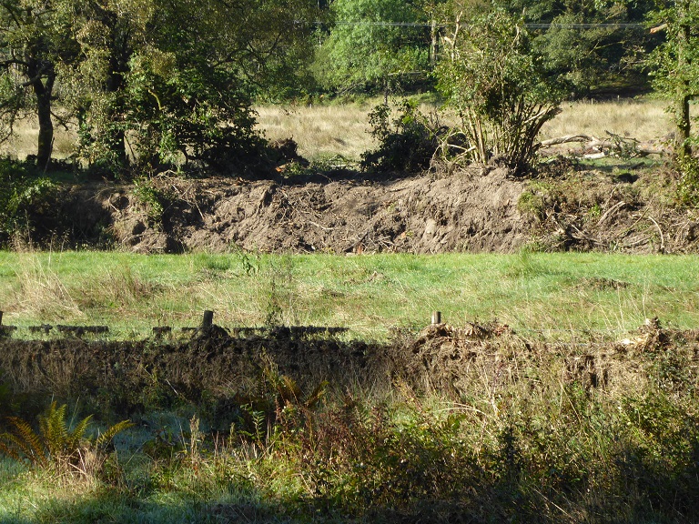
Without the alder, the damage to the banks would have been far worse and the likelihood of the river changing its course much higher. With catastrophic events like this increasing in frequency, there may not be the time now for the alder to grow back before the next one. It appears to me there is now a real risk of us entering a vicious circle of ever-increasing damage.
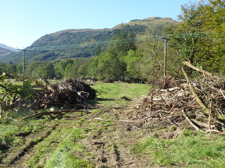
Landslips galore
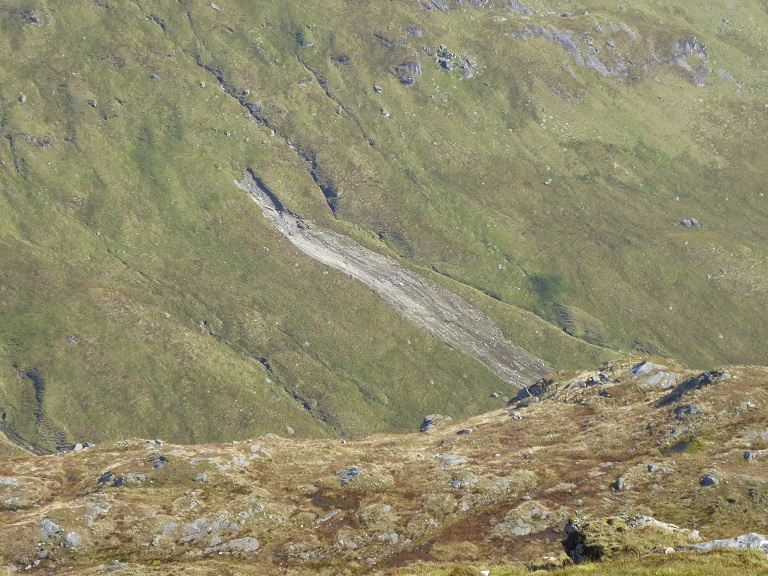
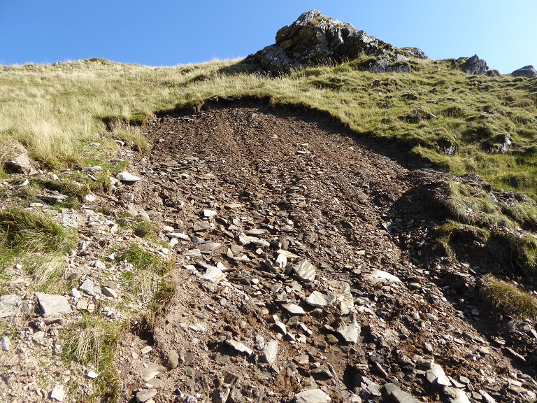
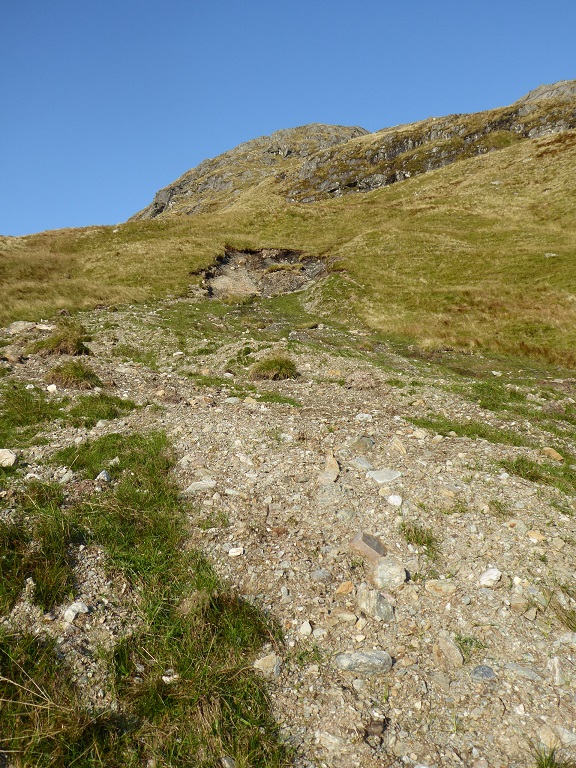
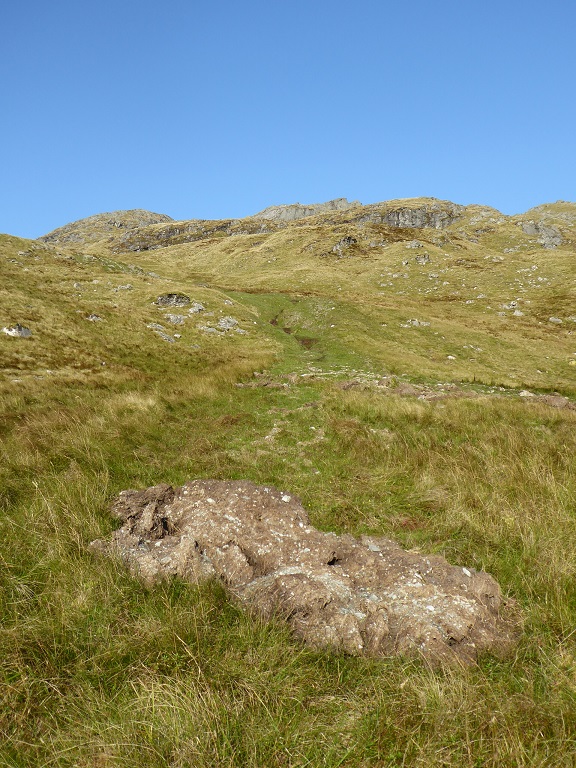
While there was plenty of evidence for the impact of the rainfall on the way up to the Ben Glas hydro (which I will cover in further posts), the most striking were the landslips (see also top photo). The first major one I came across was on the most popular walking route up Beinn Chabhair where the ground starts to steepen.
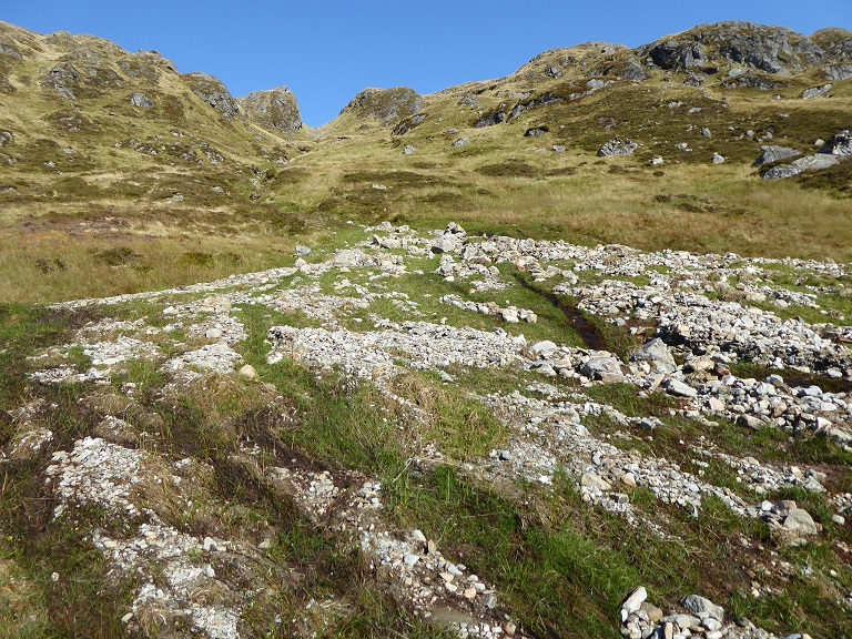
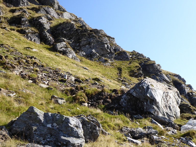
Once over the summit of Beinn Chabhair, the number and extent of the landslips were even more striking:
The two landslips on the left bear a strong resemblance to avalanches triggered at particular point and which then spread out as they gain momentum down the hill carrying all before them. Maybe they were caused by avalanches and not the recent rain? I was not close enough to check..
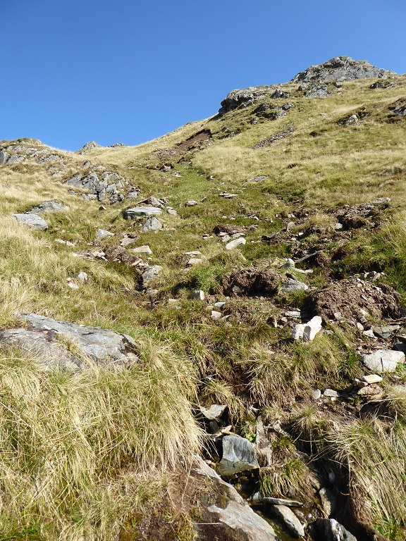
Almost all the other erosion scars, however, were recent and appear to have been caused by the rainfall on 5th August
This landslip was quite scary from a hillwalking perspective. It appears that landslips have become a risk which, like avalanches, walkers need to consider when planning routes. Time to revise the mountain leader training courses and mountaineering manuals?
While the soil and rock from this landslip came to a halt half way down the slope, the amount of water flowing down the hill must have been extraordinary, both to flatten this amount of vegetation and to carry huge lumps of peat down with it.
What explains the landslips?
If rainfall induced landslips were a regular occurrence in these hills, there would be obvious evidence of these. I have been walking over the hills for far longer than I care to admit and I have seen a fair few landslips in my time. This was my eighth visit to the summit of Beinn Chabhair and I have never noted landslips here before. Indeed, I have never come across anything to this extent or scale in Scotland. The closest example I can think of are the landslips at the Rest and Be Thankful at Arrochar (see here). The fact that they have also happened fairly recently adds to the argument that extreme rainfall caused by climate change is the most important factor at work here.
The state of the ground, both soils and vegetation, also plays a large role however in how quickly water runs off the hill and how much erosion takes place. The continued sheep grazing above the Rest and Be Thankful has been a contributory factor, in my view highly significant, to the landslips that have blocked the A83.
While the Loch Lomond and Trossachs National Park Authority has been working with the Glen Falloch Estate for some time, information on grazing levels and their impact – if collected at all – appears to be a closely guarded secret. Earlier this year I obtained, after 18 months of trying, and as a result of a Decision from the Information Commissioner, a copy of a Land Management Plan the LLTNPA had developed with the estate. Its ten years old! It included the following objective for Deer:
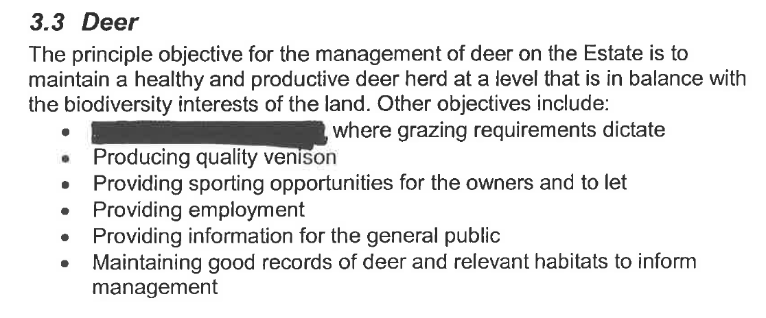
There was also an Appendix 4 deer management which included many redacted sections and no information on deer numbers. What “a healthy and productive herd at a level that is in balance with the biodiversity interests of the land” actually meant is anyone’s guess.
We do know that the Glen Falloch hills used to be very overgrazed and the vegetation in the Ben More Site of Special Scientific Interest just to the east was classified 10 years ago as being in unfavourable condition because of high grazing levels. Since then the number of sheep in these hills appear to have reduced and the condition of the vegetation in the SSSI has been judged by Scottish Natural Heritage to have improved. Set against that there was a discussion at the December Board Meeting about the very high levels of Red Deer in the National Park.
The flooding around Glen Falloch should be a prompt for information on deer and sheep numbers to be make public across the National Park to enable a more informed debate about land-use. Whether lower grazing levels here might have prevented some of the flood is, however, a very complex issue.
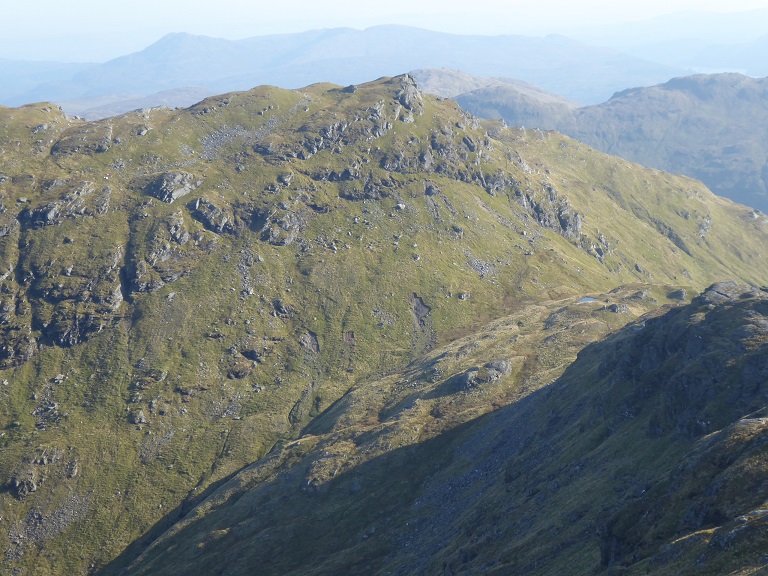
To my eye the vegetation on Beinn Chabhair and An Caisteal appears significantly more luxuriant than that on Beinn Luibhean above the Rest and Be Thanksful. It would be worth an expert – the National Park should be commissioning this work – comparing the two areas, but its possible that in extreme storm events “healthy” vegetation high up the hill and effectively above the treeline makes relatively little difference. That’s not to say it does not make a difference in more normal weather.
It would be wrong too to jump to the conclusion that if these hills were more wooded, that would prevent landslips and that planting woodland – which often requires the ground to be drained – is the solution to all flood events.
The one large landslide I saw lower down the hill started in woodland, which is not to say that had there been more trees lower down this would stemmed the flow of water and debris down hill.
So what needs to be done?
Ten years ago the LLTNPA appears to have concluded with the Glen Falloch Estate in their Management Plan – successful appeals to the Information Commissioner do reveal some interesting information! – that nothing could be done to reduce or prevent flooding:
Since then the LLTNPA has been designated a statutory “Flood Management Authority” and under the Clyde and Lomond Flood Risk Management Plan was tasked with:
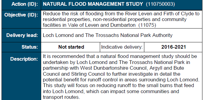
An enquiry to the Convener of the LLTNPA, James Stuart, about this was treated as an FOI request. In early September a very helpful reply from the LLTNPA’s Information Officer informed me work had NOT started on this as funding is not available. Three years into a plan and nothing done!
After what’s happened at Glen Falloch, the natural flood management study should be progressed immediately as part of the Climate Emergency. In fact Glen Falloch should provide an ideal location for collaborative work and dialogue between a number of experts, from geomorphologists and hydrologists to botanists and arboriculturalists to help us understand what has happened and what we might be able to do about it.
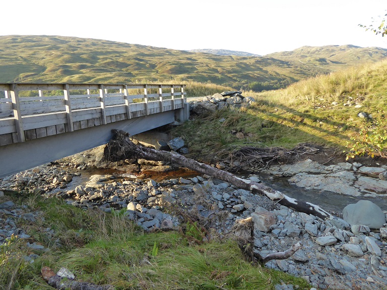
If the destruction in Glen Falloch had just been about the natural environment, the railway and the bridge to the Ben Glas campsite, the issues I have so far covered in these posts, I am far from confident the LLTNPA could be forced to act. The damage, however, has been far more extensive than what I have revealed so far and goes to the heart of how we need to tackle Climate Change as I will explain in my next post.
I recall going around the Western Highlands on my climbing ramblings after the floods of 2014 and seeing widespread and indeed, in some places, spectacular landslips on hills. To a considerable extent It is inevitable as one impact of climate change. It is noticeable also how screes in many places have reactivated – as in Glen Clunie. This happened widely from the Pentlands to the Highlands in 1978 during a prolonged wet period. There surely is needed a twofold response. One is to identify places where landslips would have a serious impact like the Rest and Be Thankful and take action to stabilise the slopes. I have done study tours in places like the Alps where slope stabilisation is a well-developed skill. One guy there wrote a handbook on it and the Canadians had it translated into English because they thought it so important. I worked with the Environment Agency in the Lake District and the main guy I worked with there had led a project in which, many years ago, every vulnerable slope in the whole Lake District had been identified and they then obtained a grant from the Lottery that funded all of these slopes being planted up. I find it astonishing that the slope above the Rest and Be Thankfull has not been planted up – as I gather from the above entry. The other thing that needs done is to assess how the vulnerability of areas to flooding etc is being influenced and this needs an integrated catchment approach. I did a lot of work on this here and abroad and that is the approach that is supposed to be required under law in Scotland.
Hi Drennan, the Rest and Be Thankful is being planted now – there have been reports saying planting would be the sensible thing to do for over 20 years now if my memory is right an extraordinary length of time. The cost of that delay, both economic cost and cost to people’s lives through delays etc, must be immense.