
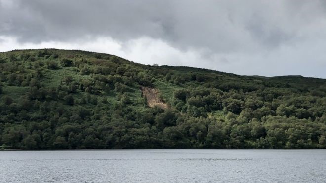
As the downpours continue, the Cabinet Secretary for the Environment, Roseanna Cunningham, should be asking herself why so much of the recent flood damage has been within our National Parks? Examples include disruption and damage to the rail network near Carrbridge in the Cairngorms (see here), at Ardlui and north of Crianlarich in the Loch Lomond and Trossachs (see here) as well as the two landslides around Loch Katrine (see here). Is this cluster of incidents within our National Parks just an unfortunate coincidence or does it tell us something about how they are being (mis-)managed?
In 2012 both our National Park Authorities and the Forestry Commission were added to the list of Public Authorities which have a statutory duty to prevent flooding. In that year SEPA also published an assessment of the potential to use “natural flood management” as a means of mitigating flooding. Since then heaps of paper have been devoted to the importance of natural flood prevention within our National Parks, within the context of local flood prevention strategies and river basin catchment management plans, but the important question is has anything actually changed?
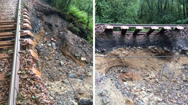
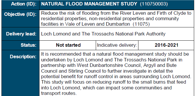
I have not visited any of the sites affected by the flooding and am unable to tell from either the photos or the media reports why the flood damage might have occurred. For example, the section of rail track north of Crianlarich that has been washed away does not appear to have located in a cutting. It appears unlikely that the flooding or damage on this stretch of the West Highland Land was caused by water flowing ALONG the railway – like in the Glasgow railway tunnel. Its difficult to ascertain from the photos, however, whether the water came down the vegetated slope above or whether the amount of rainfall falling on the steep sided track was sufficient to cause it collapse.
What is clear from the photos is that woodland restoration, which is often (rightly) recommended as a natural means of flood management, may not itself be sufficient to prevent water flowing downhill from carrying all before it.
That doesn’t mean that policy recommendations to use trees to reduce flood risk are wrong, just that however the land is managed, some landslides and local catastrophic flood events will continue. Such damaging events may of course become more common if catastrophic weather events increase alongside global warming.
The position therefore is complex. That in itself seems a good enough reason why the Cabinet Secretary for the Environment should ask our National Parks to report on the causes of what has happened, within the context of the declaration of a climate emergency, and make recommendations on what if anything could be done to reduce the likelihood of such damage in future.
How effective are flood prevention strategies and actions?
While catastrophic flood events have always occurred, what is different now is that significant work has been taken by our public authorities to look at how flood risks could be reduced. While once an act of nature, they are now risks there to be managed.
What the recent events suggest is that these risk prevention assessments are inadequate and that insufficient resources have been devoted to implementing them.
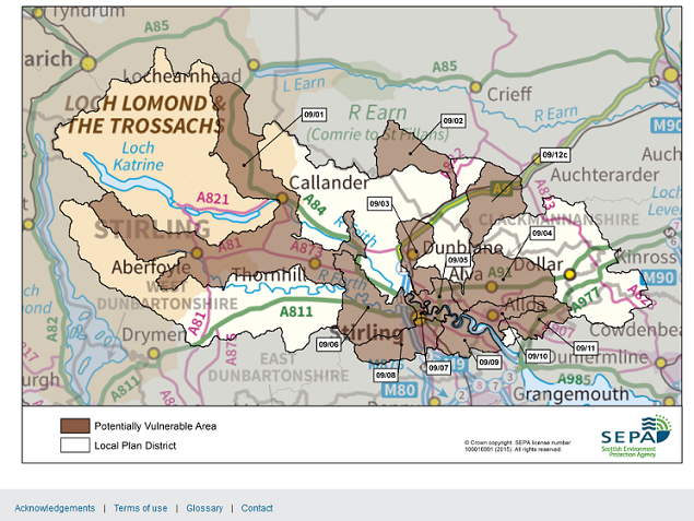
In the last week there have been two major landslips caused by flood events around Loch Katrine yet, as you can see from the map above, this has not been identified by the Scottish Environment Protection Agency (or their partners in the National Park) under the current framework as an area vulnerable to flooding. The term “Potentially Vulnerable Area” is highly misleading because its used to denote areas where flooding could be “nationally significant” rather than where it is likely to occur. The problem with this approach is that almost all the actions taken by public authorities to reduce flood risk are focussed around the vulnerable areas themselves rather than in the wider water catchments. While the water which flows off the Loch Katrine catchment, besides feeding Glasgow’s water supply, contributes to flooding downstream I can find no actions in the Strategy to address rates of water run-off there. The two events at Loch Katrine suggest this is an issue which needs examining and addressed.
The Forth Flood Prevention Strategy did, however, include a commitment to undertake a study into the neighbouring Duchray Catchment around Strathard by 2016. This appears to have morphed into the Strathard Ecosystem Services Project (see here), which includes the local community partnership area which does take in part of Glen Gyle and Loch Katrine! This HAS resulted in a number of actions from what was Forest Enterprise to reduce the rate of water run-off from plantation forestry. Good money, for example, has been spent on damming streams to reduce water flow when with a little imagination beavers could have been used to do the job naturally. While some research has been undertaken about the efficacy of these measures (see here), if they have been proven to work now would be an appropriate time to roll them out across our National Parks as a matter of urgency. We need to move from pilot projects to landscape scale conservation.
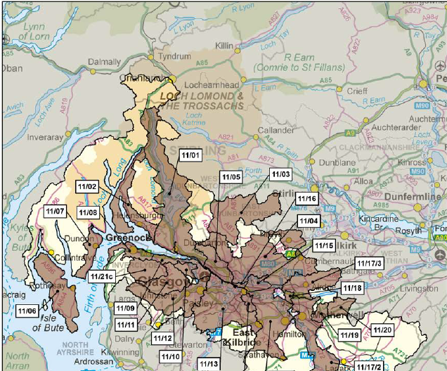
While Ardlui at the head of Loch Lomond is just included in the Lomond and Clyde Flood Prevention Strategy as a Potentially Vulnerable Area, Glen Falloch beyond is not. Under this plan the Loch Lomond and Trossachs National Park Authority was assigned the lead agency for a Natural Flood Management Study. I would have expected that to cover matters like how far overgrazing by sheep, industrial forestry and indeed the creation of run of river hydro schemes was contributing to flooding and the vulnerable areas at the southern end of Loch Lomond, including Balloch.
The timescales for the project, with a five year project delivery date, appear incredibly lax. II can find no mention of this study on the Park’s website, including the section where they now publish research they have commissioned. I have therefore have written to the Convenor, James Stuart, to ask if the work has been started or not. While there is a lot of information in the public realm about action being taken at Strathard, there appears to be nothing about actions taken around Loch Lomond. The apparent lack of action ties in with the Park’s failure to promote any natural flood prevention measures at the Rest and Be Thankful where sheep grazing has been allowed to continue.
Perhaps this failure to promote natural flood prevention/reduction around Loch Lomond is because the Park’s staff have been so busy trying to enforce the camping byelaws there that they have not had time to progress the really important conservation issues? The flood events should be a wake up call to Scottish Ministers to instruct the Park to devote their resources to where they are really needed.
Land-use, flooding and the recent flood events
The adverse impact of certain types of land-use on water run-off is well known. Many of those that are known to promote flooding are to be found around the places affected by the recent flooding:
- Plantation forestry on the Garabal estate (see here) just north and west of Ardlui and around Crianlarich
- Muirburn in the Monadliath, which increases water run-off into the upper reaches of the River Dulnain which flooded at Carrbridge. While much of the Dulnain is outwith the National Park and there is a woodland restoration project at Kinveachy, the CNPA’s decision to facilitate more intensive grouse moor management by granting planning permission to the Balavil Track (see here) will have added to the problem.
- Intensive Sheep grazing, for example in Glen Falloch and Strathfillan
- Overgrazing by deer
I am not claiming that these land-uses have been primarily responsible for the flooding in all these cases. As stated above the reasons for the flood damage may be complex but we would be extremely foolish NOT to try and establish what role role they have played.
There is also a strong economic argument for this. While landowning vested interests often claim that sheep farming, deer stalking and grouse shooting make a significant contribution to the local economy, what they never discuss is the damage they do. In this case, the closure of the West Highland Line is not just costly in itself, its damaging the tourist economy over a swathe of western Scotland at the height of the tourist season. We also know only too well the costs of the closure of the A83 so why is one farmer there apparently being given precedence over the national interest?
What other impacts have the downpours had?
The mainstream media generally only reports major events, those that are counted as newsworthy. Throughout our National Parks the rain will have caused much other damage, such as individual trees being swept away and minor landslips. They all add up. The question is how many might have been preventable?
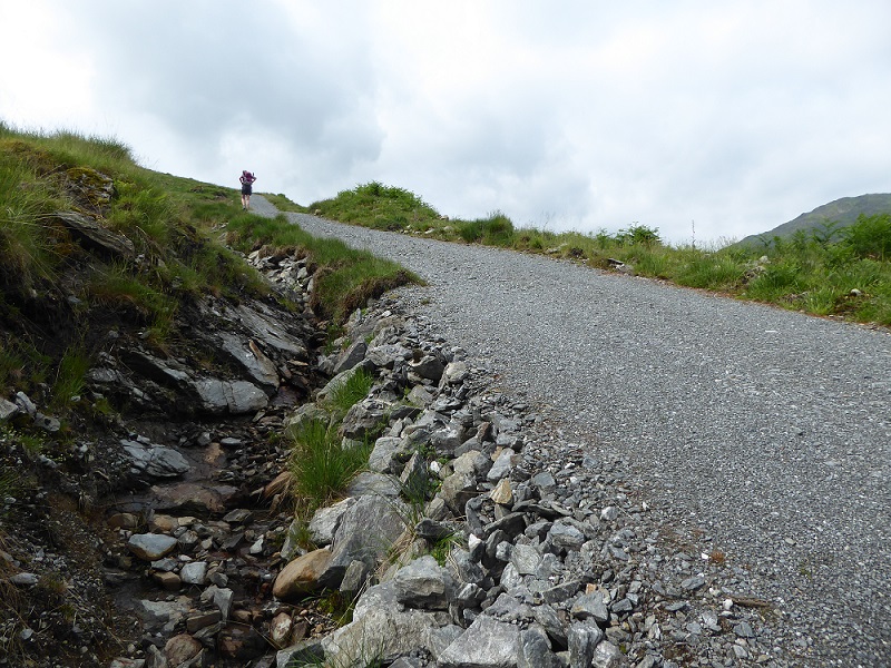
The press photos of the collapsed edges of the West Highland Line, prompt the question, how much damage has been done to the numerous hill tracks which have been created in both our National Parks over the last few years? More specifically, what damage has been done to tracks which have been granted planning permission by our National Parks and which supposedly meet the highest standards?
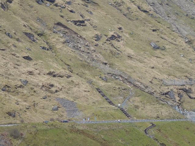
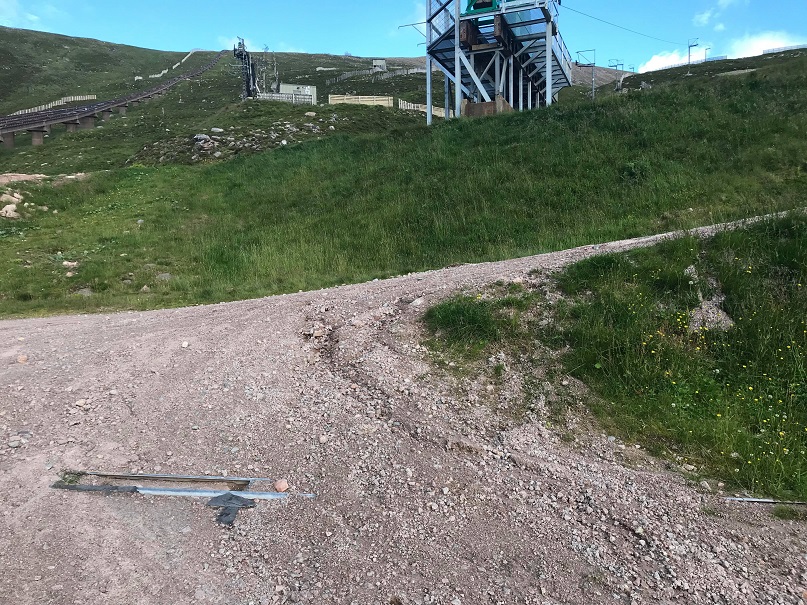
Last week, Alan Brattey sent me some telling photos of the Shieling track at Cairn Gorm which had been taken before the recent rainstorms. The track, another brainchild of Highlands and Islands Enterprise, was granted retrospective planning permission in January 2017 (a further post will appear on this in due course). At the time, parkswatch and a number of NGOs argued the track was inappropriate, breached Scottish Natural Heritage guidelines for upland track construction (it was too steep and would erode away (see here). Alan’s photos, which show how material is being washed down the mountain, suggest the critics were right – and that is before the impact of the recent rainfall.
Now consider what is likely to have happened to the 40 or so hydro tracks which have been granted consent by the Loch Lomond and Trossachs National Park Authority?
Many of these tracks breach SNH’s guidelines on upland track constuction, being far too steep and having unrestored edges both of which make them prone to erosion. The width of the tracks promotes further water run-off, adding to the flooding below, while the failure to insist on central vegetated strips has simply promoted further run-off. Whatever you think of these tracks on landscape grounds, in terms of natural flood prevention they are a disaster. This is something the Scottish Government should be requiring our National Parks to address.
If you are out and about in the next few weeks, Parkswatch would welcome any photos of damage that appears to have been caused by the recent downpours.
Time to act
If there is an emergency in an organisation like the NHS, it means all hands on deck – resources are dedicated to addressing the issue until it is resolved. Network Rail has been taking that approach to getting the railways moving again.
Since declaring a climate emergency, there have been very few signs of action from either the Scottish Government or our public authorities. The recent flood events and damage should be a wake up call to the need for a systematic review of how land-use and the development planning is being managed and contributes to the negative impacts of global warming. Our National Parks, with their statutory duty to put conservation first, should be taking a lead role on issues such as natural flood management. Unfortunately, that appears to be far from the case at present and in some ways they are actively contributing to making the problems worse. Our National Parks need to change if we are to see any really effective action from them.
Post-script – flooding and Flamingo Land
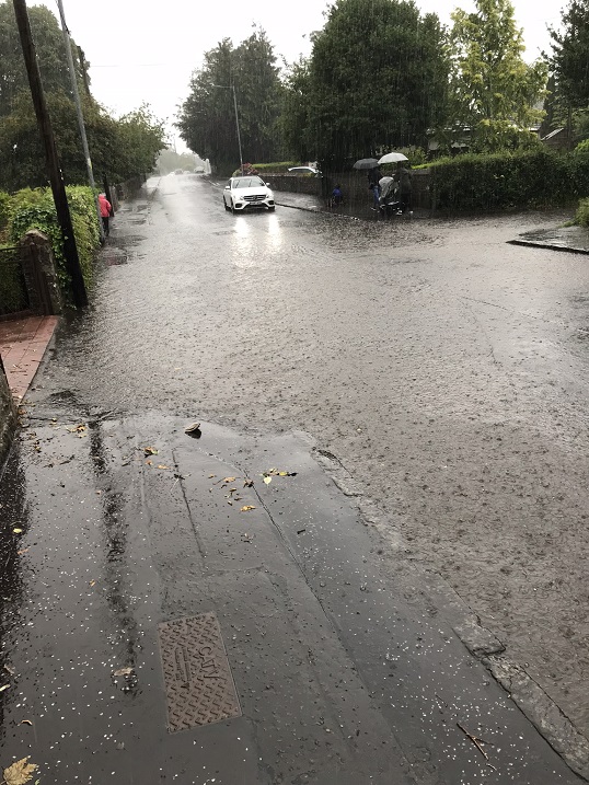
As chance would have it, a reader from Balloch sent me this photo of flooding there yesterday evening which provides an illustration of the issues mentioned in the comment below from D.Sutton that sustainable urban drainage is a joke. How much worse will this flooding become if Flamingo Land are allowed to build housing on the land above around Woodbank House? Should any developments be allowed above land which already floods?
No new housing schemes now have an EIA. Most SUDS (Sustainable Urban Drainage Schemes) schemes are a joke. But with most developments having some 30% to 36% of the land “impenetrable” (tarmac or concrete) – leading to a much higher water run off – it is hardly surprising that flooding has increased?
In South Lanarkshire we have the joy of new development over-loading the existing combined sewers. So lots of road works and sewerage overflows!!
Part of the problem is surely the overly complicated and fragmented responsibilities for flood managment. I’m not convinced by the argument that this is a NP problem. They just happen to have a lot of steep topography, and at this time of year are busy, so the impacts are more evident.
The landslides around Katrine may not have been caused by flooding – landslides can be caused by high soil water pore pressure. With the recent rainfall this would seem highly likely as a mechanism, rather than overland flow. It seems therefore a bit unfair to expect SEPA to have mapped this potential when it is not their responsibility – they only deal with flood risk , not landslides.
I can’t agree that a potentially vulnerable area is a misleading term. It’s right that investment is focused on areas which need it most, and those should be the most vulnerable areas. This designation does not stop anyone looking at solutions which involve upstream/catchment management. Natural Flood Managment measures can only go so far, and that’s probably the reason that many LA’s with limited budgets are not spending a lot of time looking at them. Unfortunately, current day flood risk is a complex mix of runoff generation and the historically inappropriate location of housing and infrastructure, something which is difficult for natural methods to deal with effectively on their own (but they should be part of the mix). The current evidence base is undoubtedly hampering uptake.
The idea that RoR hydro may be contributing to flooding is not one that is often discussed and it’s not obvious why it would – at higher flows the RoR schemes tend to have very little impact on flow regimes. As for forestry, the picture is complex, but some very interesting work was done at Balquidder some years ago on this. It’s definitely far too simplistic to say commercial forestry is bad and native is good (when it comes to flooding anyway).
In response to Dave B’s comment above, I reckon SuDS might be more useful if they were built as designed. In heavy rain, I observed nearly all rainfall bypassing my local SUDs and going straight into the river.
In reply to J Ledingham’s reply above, the point about RoR Hydro schemes and flooding was not (from my reading of the article) that the hydro schemes are themselves contributing to the flooding, but that the tracks put in when the schemes are built (which are often badly designed and poorly finished) will be leading to excessive run off and will themselves be suffering from erosion due their poor design and finish.
I agree with the statement that SUDS schemes might be more useful if they were built as designed. Last year I brought to CNPA Planning Authority’s attention that a newly constructed SUDS pond next to my property had very clearly not been built to drawing. The SUDS pond embankment had been considerably widened reducing the capacity of the neighbouring flood plain. The developer’s consultant had stated that nothing was wrong. It took me 3 months of persistence to finally convince CNPA Planning that I was right and modifications were eventually carried out.
My point is that I am convinced that CNPA Planning would have signed off this SUDS pond as built to drawing, if I had not persisted in showing them the obvious fault. This incident is indicative of rising trend of the failure of our Planning Authorities to effectively monitor and enforce the requirements within planning permissions.