If you see a digger in the hills……………report it!
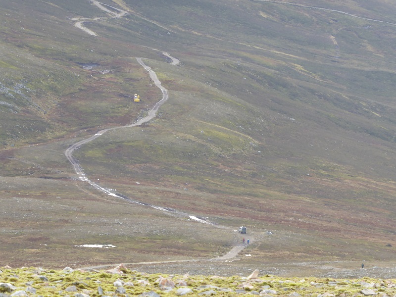
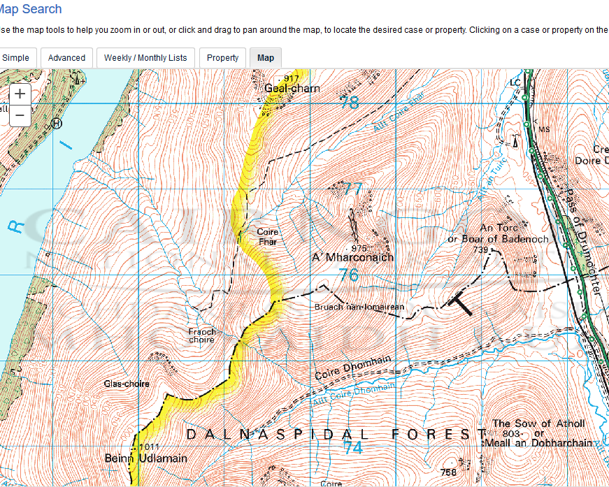
On Friday, I went for a run up Geal Charn and went just beyond the summit because the views then open up down Loch Ericht. There was a digger a little way to the south on what used to be a stalkers path into the Fraoch Choire. Over the last ten years or so new bulldozed tracks have proliferated on both sides of the Drumochter pass and had a massive impact on the scenery.
Most of land on the north side of the Drumochter pass is part of the North Drumochter or Ralia Estate as it is sometimes known. As far as I can see from the National Park and Highland Council planning portals only two of the North Drumochter tracks has had planning permission, a short section south of the telephone mast in the Glen back in 2012 and a section of the Beauly Denny construction track running north from Drumochter Lodge. The tracks on the open hillside appear not to have been subject to planning at all.
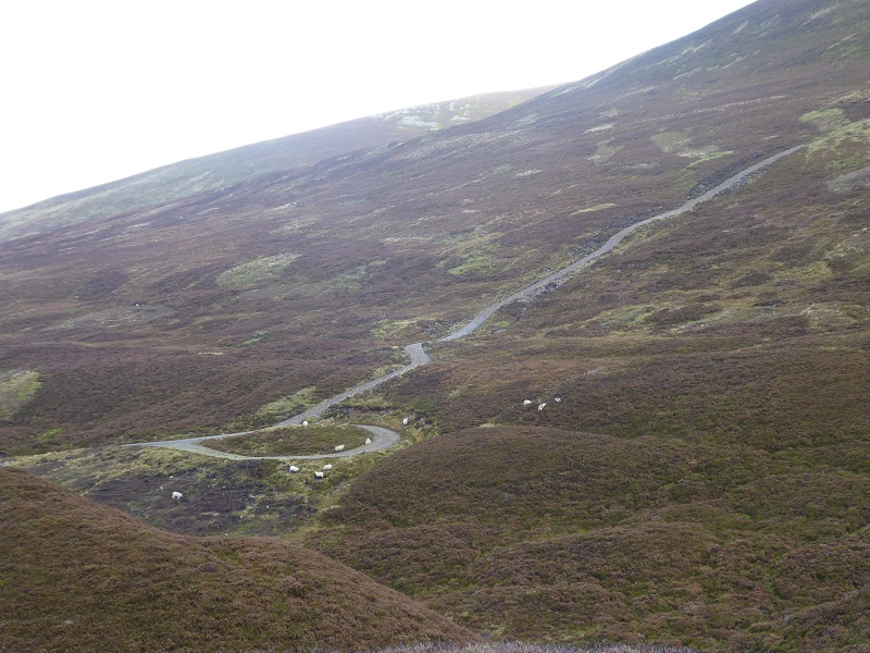
The problem has been that under the old planning rules agricultural and forestry tracks did not need planning permission except in National Scenic Areas. Estates used the presence of a few sheep, as in the first photo above, to claim these were agricultural tracks when they have been primarily used for grouse moor management. However, after coming under considerable pressure from environmental and recreational NGOs, in December 2014 the Scottish Government introduced the Prior Notification system where landowners are supposed to notify planning authorities of the creation of any new track and any works to existing tracks which effectively extend them (e.g broadening the width of the track).
Many estates, however, are not observing the new rules and its a considerable challenge for Planning Authorities to monitor what is going on on the ground. (Its not possible for planning authorities to take enforcement action against works that are more than three years old). The LINK hilltrack campaign has had considerable success encouraging hillwalkers to report new tracks but one of the challenges for both LINK and planning authorities is to determine when the track work was done . The presence of diggers however provide evidence that work is being done.
What struck me on Geal Charn, a popular Munro, is just how many hillwalkers must pass track construction works on the hill and assume that all is legitimate. If you care about the landscape, report it!. A good place to start is the Link Hill tracks group (see here).
Has the work on this track been granted planning permission or been properly notified?
You can also report direct to the Planning Authority. Several planning authorities, including the Cairngorms National Park, are now placing all Prior Notifications on their planning portals and its quite easy to check if work has had planning permission if you know the council or National Park boundary. In this case I went to Cairngorms National Park Authority planning applications and did a map search:
When you zoom in one level more than this you get to maps which depict all planning applications in red. The situation in this case is a bit complicated since the yellow marks line marks the Cairngorms National Park boundary and the digger in the photo may have just been outwith the CNPA boundary (although of course it could have done works on either side of the boundary). I therefore also checked the HIghland Council planning portal but as far as I can see no full planning application or Prior Notification has been submitted to either Planning Authority:
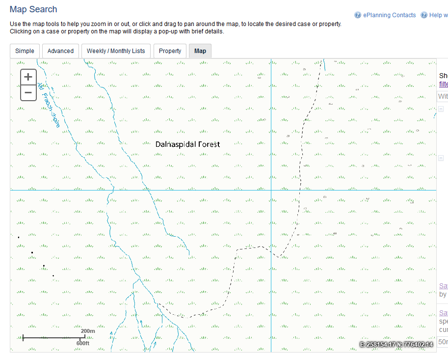
Now of course its possible that North Drumochter Estate has notified Highland Council of the work and it has not appeared on the their planning portal or that works are of a very minor nature (routine maintenance of existing tracks) and therefore don’t need to be notified. However, what the planning portals shows is that there is NO obvious explanation for the presence of the digger or that works have been agreed here. I believe therefore there is every reason to report it. So, I will!
If you find it difficult to access or the Planning Authorities on-line portals don’t let that put you off. (The IDOX planning portal still does not allow you to see planning applications on maps if you use firefox as your web browser although I reported this glitch to the Scottish Government early this year) You can email photos to the planning authority and ask if they know about this work (CNPA planning 01479 873535or planning@cairngorms.co.uk) and the LINK Hill tracks campaign (see here again) will always welcome information.
Hill tracks and protected areas
Where it can be hard for the planning authority to take enforcement action under planning law is if works are of a minor nature. This however contributes to a new problem, track creep. Tracks are gradually widened or extended or ATV tracks receive some maintenance work which over time then add up to a new track. The photos I have – and unfortunately I did not have time to take a close look which would have been better – suggest this may be happening in this case.
There are other mechanisms however by which we could prevent this happening. In protected nature sites many operations require consent from SNH and much of our National Parks are supposed to be protected in this way. SNH has a very useful website, called sitelink which enables you to do map based searches of whether a site is protected (and it works with firefox!):
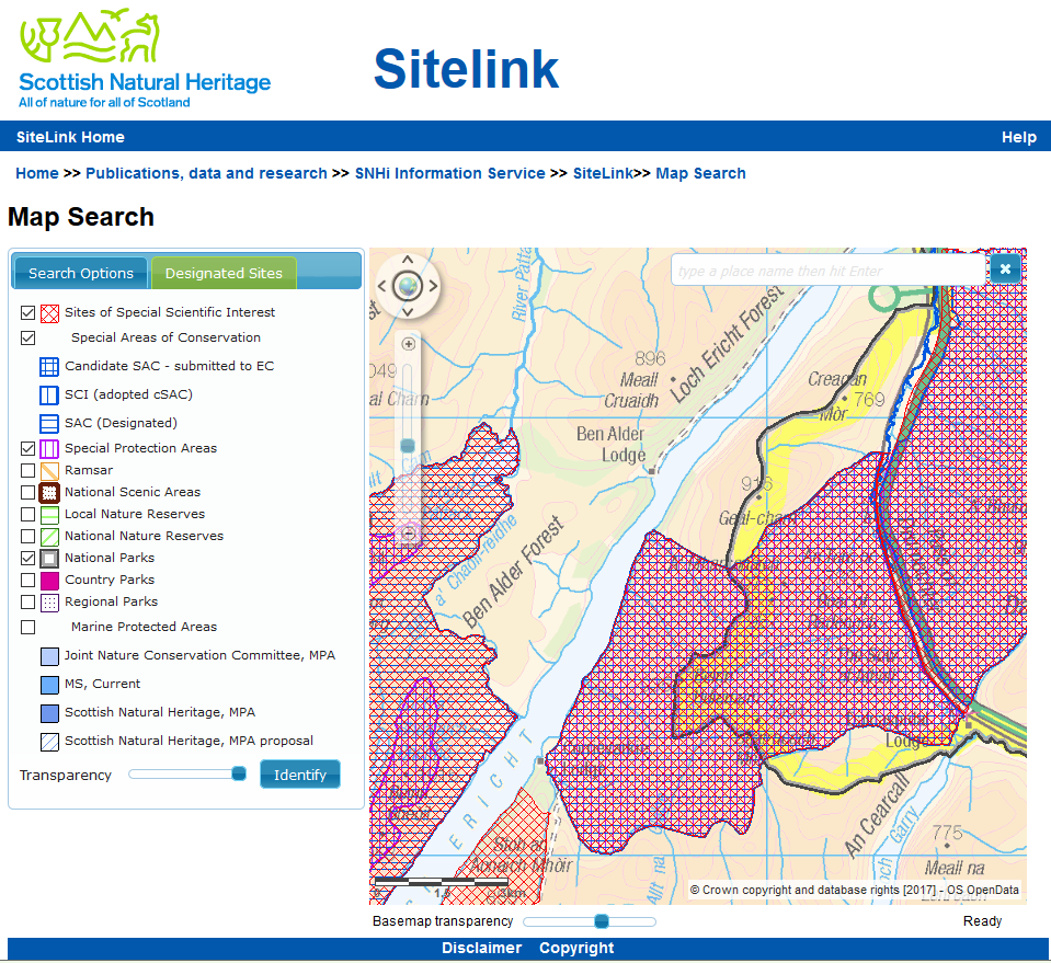
It appear that the digger, while it might have been just outwith the CNPA boundary was within the Drumochter Hills SSSI, SAC and SPA boundary. Within that SSSI all work on vegetation, ditches, tracks and off road use of vehicles requires permission from SNH. So, I will report the digger to SNH too, although in an ideal world one would hope that our National Parks at least would automatically pass on this type of information to SNH! Indeed, I believe one of the primary ways that the CNPA could prevent the further extension of hills tracks – a policy commitment set out in its new National Park Parternship Plan – would be to encourage and work with SNH to make the system of Operations Requiring Consent far more robust than it is at present.
What needs to be done
Besides using its planning powers and working more closely with SNH, it seems to me its time the CNPA (and Loch Lomond and Trossachs National Park Authority) considered using the other powers it has to bring hill tracks and hill track work under control and protect the landscape. I have previously advocated use of byelaws, which the National Park can create in order to protected nature conservation interests, to control grouse moor management. Part of that should include extension of tracks and use of diggers on the hill.
It will help build the case for that if people out on the hill report what they see and, ideally, complain.
Excellent piece. The link to LINK Hill Tracks is broken – it just comes back to this page. It should be http://www.scotlink.org/workareas/hill-tracks/.
Thanks Chris, fixed I hope, Nick
Check out the new applications for new roads through Glen Feshie to Killiehhuntly, Lynaberack and Giack!
How about checking from the air? Helicopters and aircraft from for instance the Royal Air Force-nice training for them..
Great article but just to note thar forestry tracks do also need a determination by the forestry commission as well as prior notification so if it is for forestry purposes folks can check with the local conservancy office. A location and grid reference will help.
Great article, if you are fortunate enough to fly out of Inverness on a clear day you can see the extent of these tracks there are very few areas of upland that are inaccessible to 4×4 vehicles in fact if they were marked on Maps I think it would be almost possible to drive from one side of the Highlands to the other , barely using public roads.
They are a permanent scar on the landscape and are unecessary in most cases.